Sign In
Upload
Manuals
Brands
Standard Horizon Manuals
GPS
CPN700i
Standard Horizon CPN700i Manuals
Manuals and User Guides for Standard Horizon CPN700i. We have
4
Standard Horizon CPN700i manuals available for free PDF download: Owner's Manual, Operation Manual, User Manual
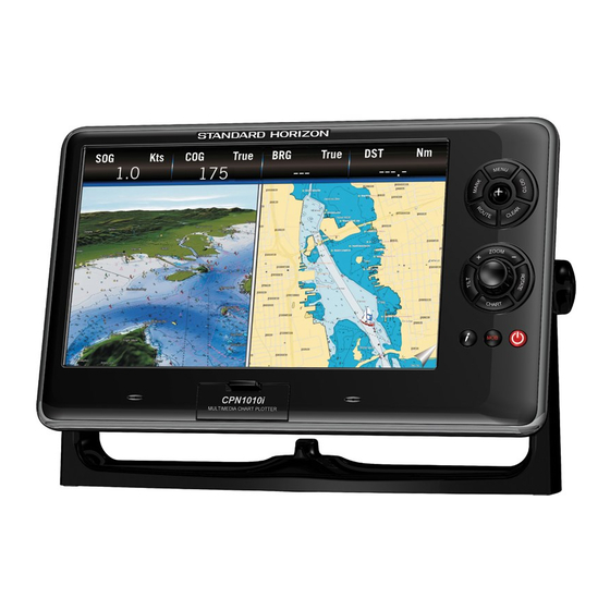
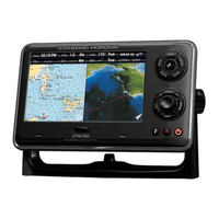
Standard Horizon CPN700i Owner's Manual (188 pages)
Multimedia Chart Plotters
Brand:
Standard Horizon
| Category:
GPS
| Size: 17 MB
Table of Contents
Table of Contents
4
Page
8
Introduction
10
Packing List
11
Optional Accessories
12
Manual Conventions
12
1 General Operation
13
Power up Sequence
13
Powering off
13
Brightness Control
14
Chart Plotter Front Panel
14
Touchscreen
15
Touchscreen Disabling (Chart Plotter Mode Only)
16
Touchscreen Keys
16
Touchscreen Keyboard
17
Touchscreen Keyboard for Chart Plotter Mode
17
Touchscreen Keyboard for Other Applications
17
Menu Description
17
Information Window
18
Warning Window
18
Selecting an Item
19
Chart Plotter Controls
19
Keys
19
PLAYING MUSIC in BACKGROUND (Chart Plotter Mode Only)
22
Starting Music in Background
22
Stopping Music in Background
22
SOFT KEYS (Chart Plotter Mode Only)
22
Closing Soft Keys
23
Memory Devices Safely Removal
23
2 Chart Plotter
24
Getting Started
24
Switching between Modes
25
Cursor Mode
25
Default Mode
25
Home Vs Cursor Mode
25
Switching between 2D and 3D Modes
26
Menu System
27
Initial Setup
28
Cursor and Menu Selection Speed
28
Changing the Ship Icon
29
Pages Selection
29
Selecting Course Up/North up
29
Assigning Page Soft Keys
31
Time Setup
31
Changing the Display Color
33
Loran TD
33
Selecting Coordinate System
33
Selecting Language
34
Chart Control Icon
35
Settings in General Setup Menu
36
Quick Access to Alarms, Track and Ais Settings
38
Alarms
38
Track
38
Ais
38
Cartography Overview
39
BUILT-IN CHARTS - for North America Users Only
39
Updating Built-In Charts
39
C-Map 4D
41
C-MAP 4D: FULL 4D Content
42
C-MAP 4D: MAX Content
42
Cpn700I and Cpn1010I Multimedia Chart Plotters Page
42
C-MAP 4D: Value Added Data
43
Value Added Data Menu
43
Removing the Sd Card
43
Using Find Services
44
Port Services
44
Port
45
Tide Stations
46
Changing the Day
46
Changing Tide Station
46
Wrecks
47
Obstructions
47
Lakes Information
48
Quick and Full Info on Lakes
48
Lakes by Name
49
Points of Interest
50
User Points
50
Coordinates
50
Information
51
Chart Display Functions
51
Functions
51
Chart Window
51
Display Mode
52
Overlay
52
Exaggeration Factor
53
Overlay Mode
53
Transparency
53
General Chart Display Functions
54
Icons Size
54
Place Names Size
54
Currents Prediction
55
Safety Status Bar (DSI - Data Safety Indicator)
55
Chart Language
56
Course Up/North up
57
Nav-Aids Presentation
57
Ship Icon
57
Compass Indicator
58
Course Time Line
58
Ship Icon Position
58
Pictures & Diagrams
59
How to Show Pictures or Diagrams of an Object
59
Creating Marks
60
Creating a New Mark on the Chart Page
60
Editing a Mark or Waypoint
60
Deleting a Mark or Waypoint
61
Moving a Mark or Waypoint
61
Marks/Waypoints (User Points) List
62
Creating/Modifying a Mark in User Points List
63
Routes
64
Creating a Route Using Waypoints
64
Changing the Name of a Route
65
Creating an Olympic Route or Boundary
65
Making Additional Routes
65
Creating a Route Using Marks on the Chart Page
66
Inserting a Waypoint into a Route
66
Deleting a Route
67
Other Settings in Route Menu
67
Route Check
67
Easy Routing (Er)
69
Warning Messages
71
Easy Routing Touchscreen Commands
72
Goto Key Operation
72
Goto Cursor
72
Goto a Route
73
Using GOTO to Select a Route
73
Goto Mark
74
Using the Shuttlepoint Knob
74
Man over Board (Mob) Function
74
Placing a Mob Point
74
Deleting a Mob Point
75
Tracks
75
Saving and Starting a New Track
76
Deleting a Track
77
Other Settings in the Track Menu
77
Trip Log & Timers
77
Trip Log Selection in Data Window
77
Count down Timer Selection in Data Window
78
Resetting the Trip Log
78
Setting the Count down Timer
79
Trip Timer Selection in Data Window
79
Handling the Trip Timer
80
User Sd Card
81
Initializing the Sd Card
81
Deleting a File from a User Sd Card
82
Loading a File from a User Sd Card
82
Transferring Files to a User Sd Card
82
Refreshing a User Sd Card
83
Main Menu
83
Chart Page
84
Customizing a
84
Selecting a Page or Menu
84
Dual
85
Single
85
Customizing Data Windows
86
Data Window Selections
86
Collapsing Data Windows
88
Additional Functions on Chart Page: Information on Objects
89
Display Mode
89
Marine Settings
90
Chart Settings
91
Depth Settings
91
Underwater Objects Settings
93
Navigation
93
Highway Page
93
Chart/Highway Page
94
Compass Page
94
GPS Setup Menu
95
GPS Status Page
95
WAAS/EGNOS Setting
95
Nmea
96
NMEA Digital Page
96
Customizing Data Boxes in the NMEA Digital Page
97
Analog Page
98
Engine & Chart (Combo) Page
98
Monitor Page
98
FISH FINDER (Optional FF525 Required)
99
Tide Page
99
Tides
99
Vhf Digital Selective Calling
100
Distress Call
101
NMEA-0183/NMEA-2000 Interfacing
101
Position Request
101
DSC Directory
102
Video Input
102
Restore Defaults
103
Video Adjustment Mode
103
Video Input Menu
103
Alarms
104
Alarms Setup Menu
104
Engine Alarm Report
105
Grounding Alarm Report
105
System Alarm Report
106
Advanced Settings
106
Navigate Menu
106
Loran TD
106
Compass (Cog) Setup
107
Data Source Priority Selection
107
Engines Name Selection
108
Input/Output (Nmea-0183) Connections
108
Input/Output
109
NMEA-0183 Output Sentences
109
Simulation
109
Navigating a Route in Simulation Mode
110
Dsc Polling
110
About Page
110
DAM Report Page
111
Ais
112
System Definitions
113
Ais Setup Menu
114
Quick Info on Ais Target
114
Ais Target Colors
114
Ais List
115
Ais-Sart
115
AIS-SART Test Mode
115
C-Map Weather Forecasts Service
116
C-Map Weather Page
117
Download Via Wi-Fi® Connection
117
Download from SD CARD
118
Forecast
118
P2N Link
119
P2N Link Activation on Cpn Series Chart Plotter
120
P2N Link Activation on Mobile Device
121
P2N Link Deactivation
121
P2N Link Deactivation on Mobile Device
123
3 Connection Manager
124
Getting Started
124
Starting the Connection Manager
124
Wi-Fi® CONNECTION
125
LIST of Wi-Fi HOTSPOTS
125
HOW to CONNECT to Wi-Fi® HOTSPOT
126
CPN Wi-Fi NETWORK
127
Wi-Fi STANDARDS SUPPORTED
127
Authentication/Encryption Protocols
127
Networking Connection: C-Map 4D Charts, Nmea & Fish Finder Data Sharing
128
Setting up Connection between Two Cpn Series Chart Plotters
128
Chart Plotter 1 Setup (with C-MAP 4D CARD Inserted)
129
Chart Plotter 2 Setup (no Chart Inserted)
130
Ethernet Configuration
131
PAIRING the CPN SERIES CHART PLOTTERS with Bluetooth® WIRELESS TECHNOLOGY
132
ACTIVATION of Bluetooth® DEVICE
132
Cpn700I and Cpn1010I Multimedia Chart Plotters Page
132
PAIRING Bluetooth® DEVICE
133
UNPAIRING Bluetooth® DEVICE
134
4 Internet Browser
135
Getting Started
135
Starting the Internet Browser
135
Browser Overview
136
Internet Browser Controls
137
How to Navigate
138
The Favorites Page
139
The History List
139
Playing Media Contents
140
Downloading Pdf Files
140
5 Media Player
141
Getting Started
141
Starting Media Player
141
Overview
142
Media Player Controls
143
Displaying Pdf Files
145
Saving Files on a Usb Thumb Drive
146
6 Installation
147
Mounting the Cpn Series Chart Plotter
147
Bracket Mounting
147
Flush Mounting the Cpn Series Chart Plotter
148
Mounting the Optional External Gps Antenna
150
Flush Mounting the Antenna
150
7 Connections
151
Overview
151
Battery Connections
152
Warning: Product Grounding
153
Warning: Product Installation and Operation
153
Nmea-0183 Connections
155
ACC2 Connections
157
CPN Series Chart Plotter to NMEA-0183 Connection Examples
157
PORT Input Selections
157
PORT Output Sentences
157
PWR/ACC1 Connections
157
Video Input Connections
160
Video Input /Output Connections for Cpn1010I
160
Video Input Connections for Cpn700I
160
Video Input Connector
160
Pre-Amp Output-External Amplifier/Speaker Connections
161
CPN Pre-Amp Connector Pin out
161
Optional Usb Thumb Drive
162
Optional Waas Gps Antenna
162
Optional Ff525 Black Box Fish Finder
163
Optional External Alarm Connection
164
Second Cpn to Share C-Map 4D Charts, Nmea & Ff Data
164
Nmea-2000 Devices
165
8 Specifications
166
Cpn700I
166
Cpn700I DIMENSIONS
167
Cpn1010I
167
Cpn1010I DIMENSIONS
168
Optional Ff525 Fish Finder
169
Optional Waas Gps Receiver
169
9 Technical Tests
170
System Test
170
Ram Menu (Reset)
170
RAM Clear
170
Backlight
171
CARTRIDGES (Used by Standard Horizon Technicians)
171
Internal Data Base Test
171
SD CARD Test
171
SERIAL PORTS (Used by Standard Horizon Technicians)
171
Change Parameters
171
Input Data Display
171
Loop-Back Test
171
10 System Update
172
System Update Procedure
172
System Update Error Messages
173
Error Message 08
174
Terms
175
Analytical Index
178
Declaration of Conformity
186
Advertisement
Standard Horizon CPN700i Owner's Manual (181 pages)
Multimedia GPS Chart Plotters
Brand:
Standard Horizon
| Category:
GPS
| Size: 15 MB
Table of Contents
Table of Contents
4
Introduction
10
Packing List
11
Optional Accessories
12
General Operation
13
Manual Conventions
13
Power up Sequence
13
Powering off
13
Brightness Control
14
Chart Plotter Front Panel
14
Touchscreen
15
Touchscreen Keyboard
16
Touchscreen Keyboard for Chart Plotter Mode
16
Touchscreen Keys
16
Touchscreen Keyboard for Other Applications
17
Menu Description
17
Information Window
18
Warning Window
18
Selecting a Item
18
Chart Plotter Controls
19
Keys
19
PLAYING MUSIC in BACKGROUND (for Chart Plotter Mode Only)
21
Starting to Play in Background
21
Stopping to Play
22
SOFT KEYS (for Chart Plotter Mode Only)
22
Closing Soft Keys
23
Memory Devices Safely Removal
23
Chart Plotter
24
Getting Started
24
Switching between Modes
25
Cursor Mode
25
Default Mode
25
Home Vs Cursor Mode
25
Switching between 2D and 3D Modes
26
Menu System
27
Initial Setup
28
Changing the Ship Icon
28
Cursor and Menu Selection Speed
28
Pages Selection
29
Selecting Course Up/North up
29
Assigning Page Soft Keys
31
Time Setup
31
Changing the Display Color
33
Loran TD
33
Selecting Coordinate System
33
Selecting Language
34
Chart Control Icon
35
Settings in General Setup Menu
36
Cartography Overview
37
Built-In Charts
37
Updating Built-In Charts
38
C-Map 4D
40
Digital Navigation Charts that Grow with Your Boating Needs
40
C-MAP 4D: FULL 4D Content
41
C-MAP 4D: MAX Content
41
C-MAP 4D: Value Added Data
42
Value Added Data Menu
42
Removing a Sd Card
42
Using Find Services
43
Port Services
43
Port
44
Tide Stations
45
Changing the Day
45
Changing Tide Station
45
Wrecks
46
Obstructions
46
Lakes Informations
47
Quick and Full Info on Lakes
48
Lakes by Name
48
Points of Interest
49
User Points
49
Coordinates
50
Informations
50
Chart Display Functions
51
4D Functions
51
Chart Window
51
Display Mode
51
Overlay
52
Overlay Mode
52
3D Exaggeration Factor
53
Transparency
53
General Chart Display Functions
53
Icon Size
53
Place Name Size
54
Safety Status Bar (DSI - Data Safety Indicator)
54
Currents Prediction
55
Chart Language
56
Course Up/North up
56
Course Time Line
57
Nav-Aids Presentation
57
Ship Icon
57
Compass Indicator
58
Ship Icon Position
58
Pictures & Diagrams
59
How to Show the Pictures or Diagrams of a Object
59
Creating Marks
60
Creating a New Mark Using the Chart Page
60
Editing a Mark or Waypoint
60
Deleting a Mark or Waypoint
61
Moving a Mark or Waypoint
61
Marks/Waypoints (User Points) List
62
Creating/Modify a New Mark in the User Points List
63
Routes
64
Changing the Name of a Route
65
Creating a Route Using Waypoints
65
Creating an Olympic Route or Boundary
66
Making Additional Routes
66
Creating a Route Using Marks on the Chart Page
67
Inserting a Waypoint into a Route
67
Deleting a Route
68
Other Settings in Route Menu
68
Route Check
68
Easy Routing (Er)
70
Warning Messages
72
Goto Key Operation
73
Goto Cursor
73
Goto a Route
74
Using GOTO to Select Route
74
Goto Mark
75
Using the Shuttlepoint Knob
75
Man over Board (Mob) Function
76
Deleting a Mob Point
76
Placing a Mob Point
76
Tracks
77
Deleting a Track
78
Other Settings in the Track Menu
78
Saving and Starting a New Track
78
Trip Log
78
Trip Log Selection in Data Window
78
Setup / Reset
79
User Sd Card
79
Formatting the Sd Card
80
Transferring Files to the Sd Card
80
Deleting a File from the Sd Card
81
Loading a File from the Sd Card
81
Refreshing the Sd Card
81
Main Menu
82
Selecting a Page or Menu
82
Chart Page
83
Customizing a Page Icon
83
Data Window Selections
84
Dual
84
Single
84
Customizing Data Windows
85
Collapsing Data Windows
86
Additional Functions on Chart Page: Information on Objects
87
Display Mode
88
Depth Settings
89
Marine Settings
89
Chart Settings
90
Highway Page
91
Navigation Pages
91
Underwater Objects Settings
91
Chart/Highway Page
92
Compass Page
92
GPS Status Page
93
Setup Menu
93
Nmea Data Pages
94
NMEA Display Page
94
WAAS/EGNOS Setting
94
Customizing Data Box in the NMEA Display Page
95
NMEA Data Page
95
FISH FINDER (Optional FF525 Required)
96
Tide Page
96
Tides
96
Vhf Digital Selective Calling
97
Distress Call
98
NMEA 0183 Interfacing
98
Position Request
98
DSC Directory
99
Video Input
99
Video Input Menu
99
Restore Defaults
100
Video Adjustment Mode
100
Advanced Settings
101
Loran TD
101
Navigate Menu
101
Compass (Cog) Setup
102
Input/Output
102
Input/Output (Nmea) Connections
102
Alarms
103
NMEA 0183 Output Sentences
103
Navigating a Route in Simulation Mode
104
Simulation
104
About Page
105
Dsc Polling
105
DAM Report Page
106
Ais
107
System Definitions
107
Menu
108
Quick Info on Ais Target
108
Ais Target Colors
109
List
109
Connection Manager
111
Getting Started
111
Starting the Connection Manager
111
Connection Manager Overview
112
Wi-Fi ® CONNECTION
112
Wi-Fi ® Standards Supported
112
Connection Manager Controls
113
How to Connect
113
Authentication/Encryption Protocols
114
Networking Connection: C-Map 4D Charts, Nmea & Fish Finder Data Sharing
115
Cpn Series Chart Plotter Setup
115
Chart Plotter 1 Setup (with C-MAP 4D CARD Inserted)
116
Chart Plotter 2 Setup (no Chart Inserted)
118
Custom Setup
120
PAIRING the CPN MULTIMEDIA CHART PLOTTERS with Bluetooth WIRELESS TECHNOLOGY
120
ACTIVATION of Bluetooth DEVICE
120
PAIRING Bluetooth DEVICE
121
UNPAIRING Bluetooth DEVICE
123
Internet Browser
124
Getting Started
124
Starting the Internet Browser
124
Browser Overview
125
Internet Browser Controls
126
How to Navigate
127
The Signal Indicator Icon
128
The Favorite Pages and History List
128
Favorites
128
The Download Manager
129
Media Player
132
Getting Started
132
Starting Media Player
132
Media Player Controls
133
Saving Files on a Usb Thumb Drive
135
Viewing and Playing Files
136
Installation
137
Mounting the Cpn Series Chart Plotter
137
Bracket Mounting
137
Flush Mounting the Cpn Series Chart Plotter
138
Mounting the Optional External Gps Antenna
140
Flush Mounting the Antenna
140
Connections
141
Overview
141
Battery Connections
142
Warning: Product Grounding
143
Warning: Product Installation and Operation
143
Nmea 0183 Connections
145
ACC 2 Connections
147
PORT Input Selections
147
PORT Output Sentences
147
PWR/ACC1 Connections
147
CPN Series Chart Plotter to NMEA 0183 Connection Examples
148
Video Input Connector
150
VIDEO INPUT CONNECTIONS for Cpn700I
150
VIDEO INPUT/OUTPUT CONNECTIONS for Cpn1010I
151
Pre-Amp Output - External Amplifier/Speaker Connections
151
CPN Pre-Amp Connector Pin out
152
Optional Usb Thumb Drive
152
Optional External Alarm Connection
153
Optional Gps Antenna
153
Optional Ff525 Black Box Fish Finder
153
Second Cpn to Share C-Map 4D Charts, Nmea & Ff Data
154
NMEA 2000 DEVICES and ETHERNET RADAR (for Future Release)
154
Specifications
155
Cpn700I
155
Dimensions
156
Cpn1010I
156
Dimensions
157
Optional Ff525 Fish Finder
158
Optional Waas Gps Receiver
159
Gps Connection Image
160
Technical Tests
161
System Test
161
Ram Menu (Reset)
161
RAM Clear
161
Backlight
162
CARTRIDGES (Used by Standard Horizon Technicians)
162
Internal Data Base Test
162
SD CARD Test
162
SERIAL PORTS (Used by Standard Horizon Technicians)
162
Change Parameters
162
Input Data Display
162
Loop-Back Test
162
System Update
163
System Update Procedure
163
System Update Error Messages
164
Error Messages 01, 02, 03, 04, 05, 06, 07, 09
164
Error Message 08
165
Error Messages 20, 21, 22
165
Terms
167
Analytical Index
170
Declaration of Conformity
179
Standard Horizon CPN700i Operation Manual (32 pages)
50/200kHz Black Box Fish Finder CPN Series Chart Plotters
Brand:
Standard Horizon
| Category:
GPS
| Size: 1 MB
Table of Contents
Table of Contents
3
Introduction
5
Conventions Used
5
General Information
5
Product Support Inquiries
5
Connecting the Ff525
6
Cpn700I
6
Cpn1010I
7
Operation
8
Understanding the Fish Finder Page
8
Fish Finder Display
10
Displaying the Fish Finder Page
11
Auto Full Page
11
200 Khz Full, 50 Khz Full and 50&200 Khz Display
11
200 Khz and 50 Khz Zoom
12
200 Khz and 50 Khz Fish/Chart
12
Fish Finder Soft Keys
12
Fish Finder Setup Menu
15
Fish Finder Color
15
Presets
16
Frequency
16
Gain Mode
17
Range Menu
17
Range Mode
18
Depth
18
Shift
18
Interference Rejection
18
Sensitivity Menu
19
Gain
19
STC (Sensitivity Time Control)
19
Surface Noise Filter
21
Display Setup
21
Color Settings
22
Scrolling Speed
22
White Line
22
Fish Symbols
22
A-Scope
22
Water Temperature
22
Transducer Setup
23
Keel Offset
23
Calibrate Water Speed
23
Calibrate Water Temp
23
Calibrate Aux Temp
23
Set Defaults
24
Alarms
24
Shallow Water
24
Deep Water
24
Fish
24
Temperature Upper
25
Temperature Lower
25
Temperature Rate
25
Save Settings to User Sd Card
25
Load Settings from User Sd Card
25
Restore Current Preset Defaults
26
Operation Tips
27
Index
30
Advertisement
Standard Horizon CPN700i User Manual (32 pages)
CPN Series Chart Plotters
Brand:
Standard Horizon
| Category:
GPS
| Size: 1 MB
Table of Contents
Table of Contents
3
Introduction
5
Conventions Used
5
General Information
5
Product Support Inquiries
5
Connecting the Ff525
6
Cpn700I
6
Cpn1010I
7
Operation
8
Understanding the Fish Finder Page
8
Fish Finder Display
10
Displaying the Fish Finder Page
11
Auto Full Page
11
200 Khz Full, 50 Khz Full and 50&200Khz Display
11
200 Khz and 50 Khz Zoom
12
200 Khz and 50 Khz Fish/Chart
12
Fish Finder Soft Keys
12
Fish Finder Setup Menu
15
Fish Finder Color
15
Presets
16
Frequency
16
Gain Mode
17
Range Menu
17
Range Mode
18
Depth
18
Shift
18
Interference Rejection
18
Sensitivity Menu
19
Gain
19
STC (Sensitivity Time Control)
19
Surface Noise Filter
21
Display Setup
21
Color Settings
21
Scrolling Speed
22
White Line
22
Fish Symbols
22
A-Scope
22
Water Temperature
22
Transducer Setup
23
Keel Offset
23
Calibrate Water Speed
23
Calibrate Water Temp
23
Calibrate Aux Temp
23
Set Defaults
24
Alarms
24
Shallow Water
24
Deep Water
24
Fish
24
Temperature Upper
25
Temperature Lower
25
Temperature Rate
25
Save Settings to User Sd Card
25
Load Settings from User Sd Card
25
Restore Current Preset Defaults
26
Operation Tips
27
Index
30
Advertisement
Related Products
Standard Horizon CPN1010i
Standard Horizon CP150C
Standard Horizon CP500
Standard Horizon CP1000C
Standard Horizon CP175C
Standard Horizon CPV350
Standard Horizon CPV550
STANDARD HORIZON CP300
STANDARD HORIZON CP300I
Standard Horizon CP190i
Standard Horizon Categories
Transceiver
GPS
Fish Finder
Microphone
Radio
More Standard Horizon Manuals
Login
Sign In
OR
Sign in with Facebook
Sign in with Google
Upload manual
Upload from disk
Upload from URL