Garmin G1000 Pilot's Manual
For beechcraft 58; beechcraft g58
Hide thumbs
Also See for G1000:
- Manual (724 pages) ,
- Pilot's manual (708 pages) ,
- System maintenance manual (340 pages)
Table of Contents
Advertisement
Quick Links
Advertisement
Table of Contents

Related Manuals for Garmin G1000


Summary of Contents for Garmin G1000
- Page 1 G1000 Pilot’s Guide for Beechcraft 58/G58...
- Page 2 Change Summary 190-00629-00 Rev. A 190-00629-00 Corrected figure numbering sequence in Section 7 Rev. B Record of Revisions Revision Date of Revision Revision Page Range Description 10/18/05 ------------- Initial release 11/09/05 Garmin G1000 Pilot’s Guide for Beechcraft 58/G58 190-00629-00 Rev. B...
- Page 3 Garmin is a registered trademark of Garmin Ltd. or its subsidiaries, and G1000™ is a trademark of Garmin Ltd. or its subsidiaries. ® These trademarks may not be used without the express permission of Garmin.
- Page 4 WARNING: ensure that its information remains current. Updates are released every 28 days. A database information packet is included in the G1000 package. Pilots using an outdated database do so entirely at their own risk. Garmin G1000 Pilot’s Guide for Beechcraft 58/G58...
- Page 5 Any basemap indication should be compared with other navigation sources. The illustrations in this guide are only examples. Never use the G1000 to attempt to penetrate CAUTION: a thunderstorm. Both the FAA Advisory Circular, Subject: Thunderstorms, and the Airman’s Information Manual (AIM) recommend avoiding “by at least 20 miles any thunderstorm identified as severe or...
- Page 6 All visual depictions contained within this document, including screen images of the G1000 panel NOTE: and displays, are subject to change and may not reflect the most current G1000 system. Depictions of equipment may differ slightly from the actual equipment.
- Page 7 Garmin retains the exclusive right to repair or replace the unit or software, or to offer a full refund of the purchase price, at its sole discretion.
- Page 8 WARRANTY This page intentionally left blank. Garmin G1000 Pilot’s Guide for Beechcraft 58/G58 190-00629-00 Rev. B...
- Page 9 Navigation Status Bar ..........2-22 3.3 NAV Operation..........Transponder (XPDR) Status Bar ........2-22 Frequency Range ............3-8 2.6 Supplemental Flight Data......2-23 Morse Code Identifier..........3-8 NAV Radio Selection for Navigation......3-8 Outside Air Temperature Box........2-23 190-00629-00 Rev. B Garmin G1000 Pilot’s Guide for Beechcraft 58/G58...
- Page 10 PA Function ..............5-5 Traffic Map Page Operations ........7-34 Speaker ..............5-5 7.4 Terrain Proximity Page........7-37 Marker Beacon Receiver..........5-6 Terrain Proximity Page Operations ......7-38 Navigation Radios............5-7 Displaying Obstacle Data .........7-39 viii Garmin G1000 Pilot’s Guide for Beechcraft 58/G58 190-00629-00 Rev. B...
- Page 11 8.6 AFCS Alerts ............ 8-27 GPS Status Page .............7-112 System Setup Page ..........7-116 System Status Page ..........7-126 7.10 Nearest Page Group ........7-127 Navigating to a Nearest Waypoint ......7-128 Nearest Intersections Page ........7-132 190-00629-00 Rev. B Garmin G1000 Pilot’s Guide for Beechcraft 58/G58...
- Page 12 APPENDICES Appendix A SD Card Use ........Aviation Database............. A-1 Terrain and Obstacle Databases ........ A-1 Appendix B Abbreviations, Acronyms & NAV Terms .. Appendix C Questions & Answers ......Garmin G1000 Pilot’s Guide for Beechcraft 58/G58 190-00629-00 Rev. B...
- Page 13 G1000 System Overview...
-
Page 15: System Description
This System Overview Pilot’ s Guide provides a basic This section gives a brief description of the G1000 description of the G1000 System as it pertains to the System. A G1000 system block diagram is given in Beechcraft 58/G58. The description includes the Garmin Figure 1-1. - Page 16 SYSTEM OVERVIEW • GDU 1040/GDU 1043 – The G1000 features two Each GIA 63 also contains the AFCS software which controls the Flight Director. During normal displays, the GDU 1040 and GDU 1043. The GDU 1040 is a 10.4-inch LCD display with 1024 x 768 operation, the GRS 77 AHRS and GDC 74A Air Data resolution and is configured as a Primary Flight...
-
Page 17: Optional Equipment
This System Overview only covers the baseline RS-485 digital interface. configuration of the G1000. Descriptions and procedures relating to optional equipment is covered in the G1000 • GTX 33 – The GTX 33 is a solid-state, Mode-S Optional Equipment section. Consult a Garmin authorized... -
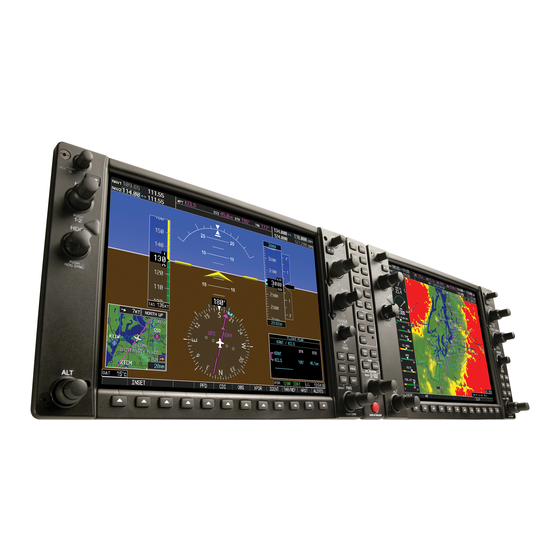
Page 18: Pfd/Mfd Controls
SYSTEM OVERVIEW 1.4 PFD/MFD CONTROLS Figure 1-2 PFD/MFD Controls MFD Only Garmin G1000 Pilot’s Guide for the Beechcraft 58/G58 190-00629-00 Rev. B... - Page 19 When the G1000 course. The course is only adjustable when the HSI is in displays a list that is too long for the display screen, a VOR1, VOR2, or OBS/SUSP mode.
-
Page 20: Secure Digital Cards
(26) APR Key – Selects/deselects the Approach mode. (27, 28) NOSE UP/NOSE DN Keys – Controls the active pitch reference for the Pitch Hold, Vertical Speed, and Flight Level Change modes. Garmin G1000 Pilot’s Guide for the Beechcraft 58/G58 190-00629-00 Rev. B... -
Page 21: System Power-Up
1.6 SYSTEM POWER-UP NOTE: Refer to the Beechcraft 58/G58 Pilot’s Operating Handbook (POH) for specific procedures The G1000 system is integrated with the aircraft concerning avionics power application and electrical system and receives power directly from electrical emergency power supply operation. - Page 22 • Obstacle database name and version and proceed to the Navigation Map Page. • Terrain database name and version • Aviation database name, version and effective dates Figure 1-4 MFD Power-up Page Garmin G1000 Pilot’s Guide for the Beechcraft 58/G58 190-00629-00 Rev. B...
-
Page 23: System Operation
SYSTEM OVERVIEW 1.7 DISPLAY BACKLIGHTING 1.8 SYSTEM OPERATION The G1000 PFD and MFD displays use photocell NORMAL MODE technology to automatically adjust for ambient lighting conditions. Photocell calibration curves are pre-configured The PFD and MFD are connected together on a single... -
Page 24: Reversionary Mode
74A, GEA 71 and GTX 33, as required. The change to AFCS PREFLIGHT TEST backup paths is completely automated for all LRUs, and When power is applied to the G1000, the AFCS system no pilot action is required. starts preflight system tests. ‘PFT’ is annunciated on the PFD at the AFCS System Status field. -
Page 25: Ahrs Operation
PFD does become invalid (as GPS Input Failure indicated by a red ‘X’). The G1000 system provides two sources of GPS NOTE: Please refer to the Annunciations and information. If a single GPS receiver fails, or if the Alerts Pilot’s Guide for specific AHRS alert... - Page 26 SYSTEM OVERVIEW This page intentionally left blank 1-12 Garmin G1000 Pilot’s Guide for the Beechcraft 58/G58 190-00629-00 Rev. B...
- Page 27 G1000 Primary Flight Display SECTION 2 PRIMARY FLIGHT DISPLAY...
- Page 28 Garmin G1000 Pilot’s Guide for Beechcraft 58/G58 190-00629-00 Rev. B...
-
Page 29: Introduction
– Altimeter with Selected Altitude and Barometric please refer to the backup instruments. Setting Boxes – Vertical Deviation/Glideslope Indicator This section describes the major features of the G1000 – Marker Beacon Annunciations Primary Flight Display (PFD) as installed on Beechcraft 58/ – Vertical Speed Indicator G58 aircraft. - Page 30 COM Frequency Window Outside Air Temperature Box TAWS Alert Annunciation Softkeys Navigation Status Bar System Time Box Slip/Skid Indicator Transponder Status Bar Attitude Indicator Turn Rate Indicator Figure 2-1 Default PFD Information Garmin G1000 Pilot’s Guide for Beechcraft 58/G58 190-00629-00 Rev. B...
- Page 31 Traffic Annunciation Alerts Window Selected Heading Box Selected Course Box Inset Map Annunciation Window DME Information Window Vertical Deviation/Glideslope Indicator BRG Information Windows Marker Beacon Annunciation Figure 2-2 Additional PFD Information 190-00629-00 Rev. B Garmin G1000 Pilot’s Guide for Beechcraft 58/G58...
-
Page 32: Backlighting
Turn the small FMS knob to display the selec- tion window. Turn the FMS knob to select • Auto (default) – The G1000 adjusts backlighting ‘MANUAL’, then press the ENT key. automatically with reference to the amount of light in the cockpit With the intensity value now highlighted, •... -
Page 33: Softkey Function
Inset Map pressed) TERRAIN – Displays terrain information on Inset BACK – Returns to previous level softkeys STRMSCP (optional) – Displays lightning data on Inset Map (within 200-nm radius of aircraft) 190-00629-00 Rev. B Garmin G1000 Pilot’s Guide for Beechcraft 58/G58... -
Page 34: Mode Selection
BKSP – Removes numbers entered one by one BACK – Returns to previous level softkeys IDENT – Provides special aircraft position identi- fication to ATC BACK – Returns to previous level softkeys Garmin G1000 Pilot’s Guide for Beechcraft 58/G58 190-00629-00 Rev. B... - Page 35 ��� ����� ������� ���� ������� ������ �� ���� ���� ������ ������� ����� ��� ���� �� ��� ������� �� ������ �� ��� ��� ����� ��������� ������� ������� Figure 2-6 INSET Softkeys 190-00629-00 Rev. B Garmin G1000 Pilot’s Guide for Beechcraft 58/G58...
- Page 36 �� ��� ��� ����� ��������� � � � � � � � � ����� ���� ���� ������ ����� ��� ����� �� ���� �������� �� ������ �� ��� ��� ����� ��������� Figure 2-8 XPDR Softkeys Garmin G1000 Pilot’s Guide for Beechcraft 58/G58 190-00629-00 Rev. B...
-
Page 37: Flight Instruments
Timer/References Window (refer to the Auxiliary Windows portion of this Flight Instruments section). When ON, the Figure 2-10 Red Pointer at V Vspeeds are displayed to the right of the airspeed scale 190-00629-00 Rev. B Garmin G1000 Pilot’s Guide for Beechcraft 58/G58... -
Page 38: Attitude Indicator
• Roll indication • Slip/Skid indication Roll Pointer Roll Scale Horizon Line Aircraft Symbol Land Representation Pitch Scale Slip/Skid Indicator Sky Representation Roll Scale Zero Figure 2-12 Attitude Indicator 2-10 Garmin G1000 Pilot’s Guide for Beechcraft 58/G58 190-00629-00 Rev. B... - Page 39 Slip/Skid Indicator displacement is equal to one ball displacement on a traditional Slip/Skid Indicator. Nose High Nose Low Figure 2-13 Pitch Attitude Warnings Figure 2-14 Roll and Slip/Skid Indication 190-00629-00 Rev. B Garmin G1000 Pilot’s Guide for Beechcraft 58/G58 2-11...
-
Page 40: Altimeter
The numeric labels and major tick marks are shown at intervals of 100 feet. Minor tick marks are at intervals of 20 feet. The current altitude is displayed in the black pointer. 2-12 Garmin G1000 Pilot’s Guide for Beechcraft 58/G58 190-00629-00 Rev. B... - Page 41 Altitude Box flashes yellow text on a black background for five seconds to indicate the deviation. Within 1000 ft Within 200 ft Deviation of ±200 ft Figure 2-16 Altitude Alerting Visual Annunciations Figure 2-17 Altimeter (Metric) 190-00629-00 Rev. B Garmin G1000 Pilot’s Guide for Beechcraft 58/G58 2-13...
-
Page 42: Vertical Deviation/Glideslope Indicator
NOTE: Digits appear in the pointer when the climb or descent rate exceeds 100 fpm. Vertical Deviation/Glideslope Indicator Vertical Speed Pointer Figure 2-18 Marker Beacon and Vertical Deviation Figure 2-19 Vertical Speed Indicator 2-14 Garmin G1000 Pilot’s Guide for Beechcraft 58/G58 190-00629-00 Rev. B... -
Page 43: Horizontal Situation Indicator
The TO/FROM arrow rotates with the Flight Phase course pointer and is displayed when the active NAVAID Turn Rate and Heading Trend Vector is received. Heading Lubber Line Figure 2-20 360˚ Horizontal Situation Indicator 190-00629-00 Rev. B Garmin G1000 Pilot’s Guide for Beechcraft 58/G58 2-15... - Page 44 NOTE: The heading displayed on the HSI is always Figure 2-21 Arc HSI magnetic, even if the NAV ANGLE is set to ‘TRUE’ in the AUX System Setup Page on the MFD. 2-16 Garmin G1000 Pilot’s Guide for Beechcraft 58/G58 190-00629-00 Rev. B...
- Page 45 18 degrees from the current heading. Turn Rate Trend Vector (standard rate) Figure 2-26 Standard-Rate Turn Indication Figure 2-27 Course Deviation Indicator 190-00629-00 Rev. B Garmin G1000 Pilot’s Guide for Beechcraft 58/G58 2-17...
- Page 46 “NO DATA”. When NAV1 or NAV2 is the selected bearing source, the frequency is replaced by the station Pointer Bearing identifier when the station is in range. Icon Source Figure 2-30 BRG2 Information Window 2-18 Garmin G1000 Pilot’s Guide for Beechcraft 58/G58 190-00629-00 Rev. B...
- Page 47 The optional DME radio is a Honeywell KN63 remote- mounted, 200-channel, 100-watt, all-solid-state digital NOTE: The Radio Tuning Window is only available DME which provides distance information to the G1000. if a DME radio is installed. Press the PFD softkey followed by the DME softkey The Radio Tuning Window is displayed by pressing the to display the DME Information Window.
- Page 48 NAV2 standby frequency. Press the CDI softkey a third time to return to Figure 2-34 GPS INTEG, GPS SUSP, LOC1 and VOR2 GPS. 2-20 Garmin G1000 Pilot’s Guide for Beechcraft 58/G58 190-00629-00 Rev. B...
-
Page 49: Communication Frequency Window
NAV2 frequency is a valid, identified frequency • Color-coded indication of the active NAV receiver NOTE: Operating procedures for the NAV Frequency Window are located in the NAV/COM section. 190-00629-00 Rev. B Garmin G1000 Pilot’s Guide for Beechcraft 58/G58 2-21... -
Page 50: Navigation Status Bar
The VFR softkey can be used to enter the pre-programmed VFR code (1200 in the USA only) selected in G1000 configuration mode. NOTE: Refer to ICAO standards for VFR codes in Figure 2-37 Navigation Status Bar Information Examples other countries. -
Page 51: Supplemental Flight Data
• Aircraft icon • Traffic data • Topographic data • Terrain data • Weather information (optional) • Enabled map features • Active navigation route • Track vector • Fuel ring (reserve) 190-00629-00 Rev. B Garmin G1000 Pilot’s Guide for Beechcraft 58/G58 2-23... - Page 52 Lightning Icon (optional) Terrain Icon NOTE: Refer to the Multi Function Display section NAV Compass for more details about Traffic Advisory System Map Orientation (TAS). Figure 2-42 Inset Map 2-24 Garmin G1000 Pilot’s Guide for Beechcraft 58/G58 190-00629-00 Rev. B...
- Page 53 NOTE: Refer to the Appendix for more details the map. about terrain. NOTE: The airspace boundary stays highlighted for approximately four seconds before returning to normal shading. 190-00629-00 Rev. B Garmin G1000 Pilot’s Guide for Beechcraft 58/G58 2-25...
-
Page 54: Auxiliary Window Keys
The MENU key opens the PFD Setup Menu if no Auxiliary Window is open. Figure 2-43 PFD Auxiliary Window Keys 2-26 Garmin G1000 Pilot’s Guide for Beechcraft 58/G58 190-00629-00 Rev. B... -
Page 55: Working With Menus
• TIMER/REFERENCES • NEAREST Much G1000 operation is accomplished using a menu • DIRECT-TO interface. The G1000 has a bezel-mounted dedicated • FLIGHT PLAN MENU key that displays a context-sensitive list of options •... - Page 56 ENT key. The UP/DOWN field is now highlighted. Turn the small FMS knob to display the UP/ NOTE: If the G1000 is set to variable (“PFD DOWN window. ENTRY”) and the flight ID entry field on the Timer/ Turn the FMS knob to select ‘UP’...
- Page 57 From the Timer/References Window, press the Figure 2-48 Nearest Airports Window MENU key. Turn the FMS knob to highlight ‘Restore Defaults’ and press the ENT key. Press the TMR/REF softkey to remove the window. 190-00629-00 Rev. B Garmin G1000 Pilot’s Guide for Beechcraft 58/G58 2-29...
- Page 58 FMS knob to highlight the desired field. Turn the FMS knobs to select the desired loca- tion, then press the ENT key. Turn the large FMS knob to highlight ‘BACK’, then press the ENT key. 2-30 Garmin G1000 Pilot’s Guide for Beechcraft 58/G58 190-00629-00 Rev. B...
- Page 59 • From a list of the 25 nearest airports Turn the FMS knob to scroll through the list and highlight the desired waypoint, then press the ENT key. Press the ENT key again to activate the direct-to. 190-00629-00 Rev. B Garmin G1000 Pilot’s Guide for Beechcraft 58/G58 2-31...
- Page 60 Flight plans can be created, edited and activated from Press the ENT key again to activate the direct-to. the PFD. The G1000 allows for the creation up to 99 flight plans, with up to 31 waypoints in each flight plan.
- Page 61 flashing on the next waypoint When storing flight plans with an approach, departure, field. or arrival, the G1000 uses the waypoint information from the current database to define the waypoints. If the Repeat step 3 above to enter the identifier for navigation database is changed or updated, the G1000 each additional waypoint.
- Page 62 Turn the FMS knob to highlight ‘Invert Flight Plan’, then press the ENT key. The flight plan is now reversed and activated. Figure 2-56 Delete Flight Plan Confirmation Window Figure 2-55 Invert Flight Plan Confirmation Window 2-34 Garmin G1000 Pilot’s Guide for Beechcraft 58/G58 190-00629-00 Rev. B...
- Page 63 Load departure allows the pilot to select a published standard instrument departure (SID) for the departure airport or replace the current departure with a new selection. When using a direct-to, the G1000 uses the nearest airport as a reference for displaying available departures.
- Page 64 ‘ACTIVATE’ adds the approach to the flight plan applies to both runways. and begins navigating the approach course. With ‘LOAD?’ highlighted, press the ENT key. 2-36 Garmin G1000 Pilot’s Guide for Beechcraft 58/G58 190-00629-00 Rev. B...
- Page 65 From the Flight Plan Window, press the MENU reference waypoint, then press the ENT key. The key to display the page menu options. G1000 displays the bearing (BRG) and distance Turn the FMS knob to highlight ‘Remove Depar- (DIS) to the closest point along the flight plan ture’, ‘Remove Arrival’, or ‘Remove Approach’,...
- Page 66 From the Flight Plan Window, press the MENU the destination airport. key to display the page menu options. Turn the FMS knob to highlight ‘Restore Defaults’, then press the ENT key. 2-38 Garmin G1000 Pilot’s Guide for Beechcraft 58/G58 190-00629-00 Rev. B...
- Page 67 ATC to the final course destination airport. segment of the approach. Figure 2-67 Arrival Figure 2-66 Select Approach Window 190-00629-00 Rev. B Garmin G1000 Pilot’s Guide for Beechcraft 58/G58 2-39...
- Page 68 NOTE: The runway window is not displayed for selection. When using a direct-to, the G1000 uses the every arrival. ‘ALL’ may appear in the runway nearest airport as a reference when displaying available field, indicating that the arrival procedure departures.
- Page 69 From an active flight plan, press the PROC key to display the Procedures options window. Turn the large FMS knob to highlight ‘Activate Approach’, then press the ENT key. 190-00629-00 Rev. B Garmin G1000 Pilot’s Guide for Beechcraft 58/G58 2-41...
-
Page 70: Reversionary Mode
• MFD failure – NAV2, COM2 and GPS2 are lost activated manually by pressing the dedicated DISPLAY BACKUP button at the bottom of the Audio Panel (refer to the Audio Panel section). Figure 2-71 PFD Reversionary Mode 2-42 Garmin G1000 Pilot’s Guide for Beechcraft 58/G58 190-00629-00 Rev. B... -
Page 71: Alerts And Annunciations
Alert messages are provided to make the pilot aware attention. A flashing “WARNING” softkey annunciation of G1000 system problems or status and may not require and an aural tone (single chime every two seconds) are pilot action. An alert message is accompanied by a used to alert the pilot of any warnings. -
Page 72: Annunciations (Optional)
The following alert annunciations appear on the PFD (to the top right of the Altimeter; see Figure 2-1) and MFD: Figure 2-75 Traffic Annunciation Figure 2-74 TAWS Annunciations 2-44 Garmin G1000 Pilot’s Guide for Beechcraft 58/G58 190-00629-00 Rev. B... - Page 73 G1000 NAV/COM SECTION 3 NAV/COM...
-
Page 75: Nav/Com Description
PFD, as shown in the figure below. Controls Controls NAV Frequency Window COM Frequency Window DME Tuning Window Figure 3-1 G1000 NAV/COM Interface (PFD) 190-00629-00 Rev. B Garmin G1000 Pilot’s Guide for the Beechcraft 58/G58... -
Page 76: Windows And Fields
Standby NAV Standby COM Radio Radio Frequency Field Frequency Field Navigation Status Bar Tuning Box Active NAV Active COM Tuning Box Figure 3-2 Frequency Fields Frequency Field Frequency Field Garmin G1000 Pilot’s Guide for the Beechcraft 58/G58 190-00629-00 Rev. B... -
Page 77: Controls
ID Knob SQ Knob Frequency Transfer Keys Dual NAV Dual COM Knob Knob • Turn to tune desired frequencies. • Press to change tuning box positions. Figure 3-3 NAV/COM Controls 190-00629-00 Rev. B Garmin G1000 Pilot’s Guide for the Beechcraft 58/G58... -
Page 78: Tuning Box
Turning the knobs clockwise increases frequency. the PFD and MFD. The NAV frequency tuning box does Turning the knobs counterclockwise decreases frequency. not change when GPS mode is selected. Garmin G1000 Pilot’s Guide for the Beechcraft 58/G58 190-00629-00 Rev. B... -
Page 79: Radio Indicators
Volume level indication remains for Pressing the NAV Frequency Transfer two seconds after the change. key toggles the NAV frequencies. Figure 3-10 Transferring COM and NAV Frequencies 190-00629-00 Rev. B Garmin G1000 Pilot’s Guide for the Beechcraft 58/G58... -
Page 80: Com Operation
COM MIC keys on the audio panel. When the COM MIC FREQUENCY SPACING key is annunciated, the associated active COM frequency The G1000 COM radios can tune either 25 kHz spacing is displayed in green in the COM Frequency window. (118.000 to 136.975 MHz) or 8.33 kHz spacing (118.000 to 136.990 MHz) for 760-channel or 3040-channel... -
Page 81: Emergency Frequency (121.500 Mhz)
Figure 3-15 Stuck Microphone Alert The COM1 MIC or COM2 MIC key annunciator on the audio panel continues to blink as long as the PTT switch remains stuck. 190-00629-00 Rev. B Garmin G1000 Pilot’s Guide for the Beechcraft 58/G58... -
Page 82: Nav Operation
The Morse code identifier for the GHM VOR NAV section can be heard. of the audio panel Figure 3-16 Morse Code Identifier Audio Figure 3-17 Selecting a NAV Radio Garmin G1000 Pilot’s Guide for the Beechcraft 58/G58 190-00629-00 Rev. B... - Page 83 NAV/COM DME TUNING Selecting DME Transceiver Pairing The following DME transceiver pairing can be The G1000 system tunes the optional DME transceiver. selected: The UHF DME frequency is paired with a VHF NAV frequency, providing DME distance information. • NAV1 – Tunes the DME frequency from the selected Frequency pairing is automatic and only the VHF NAV NAV1 frequency.
- Page 84 Turn the FMS knob to scroll through a list of frequencies. Pressing the NRST softkey opens the Nearest Airports window Figure 3-19 Loading Frequencies Figure 3-20 Nearest Airports Window (PFD) 3-10 Garmin G1000 Pilot’s Guide for the Beechcraft 58/G58 190-00629-00 Rev. B...
- Page 85 In GPS mode during any VOR/ILS approach activation, the appropriate NAV frequency is automatically loaded into the active field of NAV1. Figure 3-22 WPT – Airport Information Window 190-00629-00 Rev. B Garmin G1000 Pilot’s Guide for the Beechcraft 58/G58 3-11...
- Page 86 NAV frequency located in the Primary Information Page, may also be highlighted and loaded Frequency box. into the COM tuning box. Press the ENT key. Figure 3-23 WPT – Airport Information Page (APR) 3-12 Garmin G1000 Pilot’s Guide for the Beechcraft 58/G58 190-00629-00 Rev. B...
- Page 87 Turn the large FMS knob to highlight the VOR frequency and press the ENT key to load this frequency into the tuning box of the NAV Frequency window. Figure 3-24 WPT – VOR Information Menu 190-00629-00 Rev. B Garmin G1000 Pilot’s Guide for the Beechcraft 58/G58 3-13...
- Page 88 When the desired frequency is highlighted, press the ENT key to load this frequency into the tuning box of the NAV or COM Frequency window. 3-14 Garmin G1000 Pilot’s Guide for the Beechcraft 58/G58 190-00629-00 Rev. B...
- Page 89 Frequency box and press the ENT key to load the frequency into the tuning box of the NAV Frequency window. Figure 3-26 NRST – Nearest VOR Window 190-00629-00 Rev. B Garmin G1000 Pilot’s Guide for the Beechcraft 58/G58 3-15...
- Page 90 FMS knob to highlight the desired frequency. Press the ENT key to load the desired frequency into the COM tuning box. Figure 3-27 NRST – Nearest Frequencies Windows 3-16 Garmin G1000 Pilot’s Guide for the Beechcraft 58/G58 190-00629-00 Rev. B...
- Page 91 ‘LOAD?’ or ‘ACTIVATE?’ prompt and press the ENT key. The primary NAV frequency for the activated approach is loaded into the standby field of the selected NAV radio. Figure 3-29 Loading an Approach 190-00629-00 Rev. B Garmin G1000 Pilot’s Guide for the Beechcraft 58/G58 3-17...
- Page 92 MENU be activated with the key when the Flight Plan (within 15 nm from the FAF). See the Multi window is open. Function Display Pilot’s Guide for details. 3-18 Garmin G1000 Pilot’s Guide for the Beechcraft 58/G58 190-00629-00 Rev. B...
- Page 93 G1000 Transponder...
- Page 95 The GTX 33 transponder is integrated into the not used for code entry. Pressing the BKSP softkey backs G1000 system, offering Mode A, Mode C and Mode S up code selection to the previous digit. interrogation and reply capabilities. This pilot’ s guide...
- Page 96 55 miles from select sites. • Acquisition squitter For aircraft not equipped with TCAS or TAS, TIS Flight ID Reporting – The G1000 transponder reports provides a graphic display of traffic information. TIS aircraft identification as either the aircraft registration or a displays up to eight (8) traffic targets within 7.5 nautical...
- Page 97 ON indication appears in the mode field of Figure 4-4 Ground Mode the Transponder Status bar. NOTE: Ground mode can be overridden by pressing any one of the Mode Selection softkeys. Figure 4-6 ON Mode 190-00629-00 Rev. B Garmin G1000 Pilot’s Guide for the Beechcraft 58/G58...
- Page 98 Figure 4-8 Reply Indication Figure 4-9 Entering a Code NOTE: When entering a code, press the BKSP (backspace) softkey to back up and change code digits. 190-00629-00 Rev. B Garmin G1000 Pilot’s Guide for the Beechcraft 58/G58...
- Page 99 • 7600 – Loss of communication code inoperative. • 7700 – Emergency code • 7777 – Military interceptor operations code (NEVER SQUAWK THIS CODE) • 0000 – Code for military use in the U.S. 190-00629-00 Rev. B Garmin G1000 Pilot’s Guide for the Beechcraft 58/G58...
- Page 100 TRANSPONDER This page intentionally left blank. 190-00629-00 Rev. B Garmin G1000 Pilot’s Guide for the Beechcraft 58/G58...
- Page 101 G1000 Audio Panel...
-
Page 103: Section 5 Audio Panel Description
The unit controls marker beacon receiver audio and pressed to transmit on the selected radio. features marker beacon audio muting. As part of the G1000 Integrated Cockpit System, the The audio panel handles two separate transceivers: GMA 1347 also controls the display reversionary mode. - Page 104 • ALTITUDE WARNING (PLAY) • UNSWITCHED 1 • Intercom system (ICS) isolation keys • UNSWITCHED 2 (PILOT, COPLT) • UNSWITCHED 3 • Volume/squelch knob (VOL/SQ) • Reversionary mode button (DISPLAY BACKUP) 190-00629-00 Rev. B Garmin G1000 Pilot’s Guide for the Beechcraft 58/G58...
- Page 105 DME Audio Navigation Radio Audio Disabled on Beechcraft 58/G58 Aircraft Manual Squelch Digital Recording Playback ICS Isolation VOL/SQ VOL Annunciation SQ Annunciation Reversionary Mode Control Figure 5-1 Front Panel Controls 190-00629-00 Rev. B Garmin G1000 Pilot’s Guide for the Beechcraft 58/G58...
- Page 106 COM1 MIC, COM2 MIC, COM1, and COM2 (Figure 5-2). COM audio can be selected by pressing either the desired COM key or by pressing a COM MIC key. 190-00629-00 Rev. B Garmin G1000 Pilot’s Guide for the Beechcraft 58/G58...
-
Page 107: Split Com Function
NAV1, NAV2, DME, and MKR audio as selected, but the copilot is only able to monitor COM2. Split COM mode is cancelled by pressing the COM 1/2 key again. 190-00629-00 Rev. B Garmin G1000 Pilot’s Guide for the Beechcraft 58/G58... - Page 108 The marker beacon indicators operate NOTE: independently of the marker beacon audio and cannot be turned off. Figure 5-3 Marker Beacon Keys 190-00629-00 Rev. B Garmin G1000 Pilot’s Guide for the Beechcraft 58/G58...
- Page 109 All radio keys can be selected independently. When no further navigation radio audio is heard, the amount of background noise is reduced by the Master Figure 5-5 Navigation Radio Keys Avionics Squelch (MASQ) feature. 190-00629-00 Rev. B Garmin G1000 Pilot’s Guide for the Beechcraft 58/G58...
- Page 110 Selected radios; COPILOT pilot; passengers; Copilot pilot; passengers; MUSIC 1 MUSIC 2 Selected radios; Selected radios; Passengers; CREW pilot; copilot pilot; copilot MUSIC 2 Table 5-2 ICS Isolation Modes 190-00629-00 Rev. B Garmin G1000 Pilot’s Guide for the Beechcraft 58/G58...
- Page 111 MUSIC 1 or MUSIC 2 jacks. annunciator at the bottom of the unit is lit, intercom The current ICS isolation mode affects the distribution volume may be adjusted. of the entertainment inputs MUSIC 1. 190-00629-00 Rev. B Garmin G1000 Pilot’s Guide for the Beechcraft 58/G58...
- Page 112 (1) or two (2) beeps can be heard; one (1) beep indicates that music muting is enabled, two (2) beeps indicate music muting is disabled. 5-10 190-00629-00 Rev. B Garmin G1000 Pilot’s Guide for the Beechcraft 58/G58...
- Page 113 Pressing the key during NOTE: MKR/MUTE playback halts playback and returns the recorder/playback to normal operation. 190-00629-00 Rev. B Garmin G1000 Pilot’s Guide for the Beechcraft 58/G58 5-11...
- Page 114 AUDIO PANEL This page intentionally left blank. 5-12 190-00629-00 Rev. B Garmin G1000 Pilot’s Guide for the Beechcraft 58/G58...
- Page 115 G1000 Engine Indication System...
- Page 116 Garmin G1000 Pilot’s Guide for Beechcraft 58/G58 190-00629-00 Rev. B...
- Page 117 6.1 INTRODUCTION The following colors are used to indicate operating conditions: The G1000 Engine Indication System (EIS) provides • White (or absence of a color band) – Outside the flight crew with gauges, bar graphs, and numeric normal flight operating range (safe) readouts of engine parameters.
- Page 118 The color changes to yellow (caution) or flashes red (warning) upon exceeding areas of normal operation. Normal Warning Caution Figure 6-3 Digital Readout: Oil Temperature and Pressure Garmin G1000 Pilot’s Guide for Beechcraft 58/G58 190-00629-00 Rev. B...
- Page 119 The Fuel Quantity Indicator displays the quantity of fuel in each tank in gallons (gal). When full, the indicator displays to the maximum of 75 gal for each tank. Figure 6-4 Engine Page 190-00629-00 Rev. B Garmin G1000 Pilot’s Guide for Beechcraft 58/G58...
- Page 120 EGT and CHT information Cylinder Head Temperature about a particular cylinder. Pressing the softkey cycles Bar Graph through the cylinders of both engines simultaneously. CHT Readout (Selected Cylinders) Figure 6-5 Lean Page Garmin G1000 Pilot’s Guide for Beechcraft 58/G58 190-00629-00 Rev. B...
- Page 121 Deviation EGT Peaks From Peak (Selected Cylinders) Exhaust Gas Temperature Bar Graph EGT Readout (Selected Cylinders) Cylinder Head Temperature Bar Graph CHT Readout (Selected Cylinders) Figure 6-6 Lean Assist Mode 190-00629-00 Rev. B Garmin G1000 Pilot’s Guide for Beechcraft 58/G58...
-
Page 122: System Page
Electrical Readouts Alternator The load (current) for each alternator is shown as a Load percentage of the capacity (100 A). Bus voltages are also Bus Voltage displayed. Figure 6-7 System Page Garmin G1000 Pilot’s Guide for Beechcraft 58/G58 190-00629-00 Rev. B... - Page 123 G1000 G1000 Multi Function Display...
-
Page 125: Optional Equipment
(Model SKY899) Multi Function Display (MFD). • GWX 68 Weather Radar • GDL 69/69A XM® Radio System Figure 7-1 G1000 MFD Splash Screen 190-00629-00 Rev. B Garmin G1000 MFD Pilot’s Guide for the Beechcraft 58/G58... - Page 126 Mode S Traffic on the Powering up the MFD is part of the system power up Navigation Map. procedure. See the G1000 System Overview Pilot’ s Guide TOPO – pressing the TOPO softkey displays for details. or removes topographic information on the Navigation Map.
- Page 127 As an item is selected, the next item is automatically highlighted for selection. 190-00629-00 Rev. B Garmin G1000 MFD Pilot’s Guide for the Beechcraft 58/G58...
- Page 128 Once the last item in a checklist is selected, the ‘GO TO THE NEXT CHECKLIST?’ text is highlighted. Press the ENT key to advance to the next checklist displayed. Garmin G1000 MFD Pilot’s Guide for the Beechcraft 58/G58 190-00629-00 Rev. B...
- Page 129 Page and return to the last page that was displayed before the Checklist Page was selected. Checklist Group Checklist Number Checklist Page Checklist Page Indicator Softkeys Figure 7-2 Checklist Page (typical) Emergency Softkey 190-00629-00 Rev. B Garmin G1000 MFD Pilot’s Guide for the Beechcraft 58/G58...
- Page 130 ENGINE DONE EXIT EMERGCY ENGINE LEAN SYSTEM CYL SLCT ASSIST BACK ENGINE DCLTR CHKLIST Figure 7-3 MFD Softkeys Garmin G1000 MFD Pilot’s Guide for the Beechcraft 58/G58 190-00629-00 Rev. B...
- Page 131 Active Page Title Nearest Airports Page Nearest Intersections Page Nearest NDB Page Figure 7-5 Page Title Window Nearest VOR Page Nearest User Waypoints Page Nearest Frequencies Page Neatest Airspaces Page 190-00629-00 Rev. B Garmin G1000 MFD Pilot’s Guide for the Beechcraft 58/G58...
- Page 132 NOTE: Data is entered using the large and small FMS knob. Practice with them to become effi- Much of the operation of the G1000 MFD is cient at entering data. This will greatly reduce accomplished using a menu interface. The G1000 has...
- Page 133 (highways, cities, lakes, rivers, borders, etc.) with names (labels) Map Orientation Airspace Boundries Interstate Course Line Highways Own Aircraft Terrain Scale Map Scale Legend Page Groups Figure 7-8 Navigation Map Page 190-00629-00 Rev. B Garmin G1000 MFD Pilot’s Guide for the Beechcraft 58/G58...
- Page 134 FMS knobs, the Navigation Map Page can be selected from any page by pressing and momentarily holding the CLR (DFLT MAP) key. 7-10 Garmin G1000 MFD Pilot’s Guide for the Beechcraft 58/G58 190-00629-00 Rev. B...
- Page 135 Map Range See the map setup section of this MFD Pilot’ s Guide for Indicator instructions on how to change the map orientation. Figure 7-9 Map Range 190-00629-00 Rev. B Garmin G1000 MFD Pilot’s Guide for the Beechcraft 58/G58 7-11...
- Page 136 Navigation Map Page. Class B, Alert area Caution area, Danger area, Prohibited area Restricted area, Training area Unknown area, Warning area Terminal Zone Airspace (ATZ), Class D 7-12 Garmin G1000 MFD Pilot’s Guide for the Beechcraft 58/G58 190-00629-00 Rev. B...
- Page 137 SUA Group 5 Traffic Symbols Local Roads SUA Group 6 Traffic Labels Local Road Labels SUA Group 7 Railroads Obstacles Major Political Boundaries Table 7-1 Map Declutter Levels 190-00629-00 Rev. B Garmin G1000 MFD Pilot’s Guide for the Beechcraft 58/G58 7-13...
- Page 138 To remove the panning arrow and return to the present position, push in the joystick. 7-14 Garmin G1000 MFD Pilot’s Guide for the Beechcraft 58/G58 190-00629-00 Rev. B...
- Page 139 MULTI FUNCTION DISPLAY Distance, Latitude and longitude bearing position of pointer and elevation Panning Arrow Figure 7-10 Map Panning 190-00629-00 Rev. B Garmin G1000 MFD Pilot’s Guide for the Beechcraft 58/G58 7-15...
- Page 140 See the Navigation Map Page setup menu sec- tion. On-screen map maximum elevation On-screen map minimum elevation Aircraft altitude Maximum Ground elevation Minimum Figure 7-11 Topography Range 7-16 Garmin G1000 MFD Pilot’s Guide for the Beechcraft 58/G58 190-00629-00 Rev. B...
- Page 141 Map Page by pressing the TERRAIN softkey. Terrain volume. The G1000 displays up to eight traffic targets symbology (mountain icons) appear next to the map within a 7.5 nautical mile radius, from 3,000 feet below to range in the bottom right corner of the page indicating 3,500 feet above the requesting aircraft.
- Page 142 Navigation Map Page menu. To display the menu, press the MENU key (with the Navigation Map Page displayed). Two options are available: Map Setup, and Measure Bearing/Distance. 7-18 Garmin G1000 MFD Pilot’s Guide for the Beechcraft 58/G58 190-00629-00 Rev. B...
- Page 143 Press the FMS knob to return to the Navigation Map Page. NOTE: The Active Flight Plan Page and the Nearest Pages use the same orientation that is configured for the Navigation Map Page. 190-00629-00 Rev. B Garmin G1000 MFD Pilot’s Guide for the Beechcraft 58/G58 7-19...
- Page 144 ENT key. Press the FMS knob to return to the Navigation Press the FMS knob to return to the Navigation Map Page. Map Page. 7-20 Garmin G1000 MFD Pilot’s Guide for the Beechcraft 58/G58 190-00629-00 Rev. B...
- Page 145 ‘Off’. Press the ENT key to accept the selected option. option. Press the FMS knob to return to the Navigation Press the FMS knob to return to the Navigation Map Page. Map Page. 190-00629-00 Rev. B Garmin G1000 MFD Pilot’s Guide for the Beechcraft 58/G58 7-21...
- Page 146 NOTE: When topographic data is removed from the Navigation Map Page, all cartographic data is automatically removed and the Jeppesen Nav data is presented on a black background. 7-22 Garmin G1000 MFD Pilot’s Guide for the Beechcraft 58/G58 190-00629-00 Rev. B...
- Page 147 FMS knob to display the range list. Turn the small FMS knob to select the desired range and press the ENT key. Press the FMS knob to return to the Navigation Map Page. 190-00629-00 Rev. B Garmin G1000 MFD Pilot’s Guide for the Beechcraft 58/G58 7-23...
- Page 148 FMS knob to enter a time (00:00 to 23:59; Map Page hours:minutes). The default setting is 00:45 minutes. Press the ENT key. Press the FMS knob to return to the Navigation Map Page. 7-24 Garmin G1000 MFD Pilot’s Guide for the Beechcraft 58/G58 190-00629-00 Rev. B...
- Page 149 Beechcrafts. PAs are defined as traffic within the 4.0 nm Figure 7-14 Traffic Group Options range, within ± 1200 ft. of altitude separation, and are not traffic advisories (TAs). 190-00629-00 Rev. B Garmin G1000 MFD Pilot’s Guide for the Beechcraft 58/G58 7-25...
- Page 150 Press the ENT key to accept the selected option. option. Press the FMS knob to return to the Navigation Press the FMS knob to return to the Navigation Map Page. Map Page. 7-26 Garmin G1000 MFD Pilot’s Guide for the Beechcraft 58/G58 190-00629-00 Rev. B...
- Page 151 flight plan names appear on the display (none, small, medium, and large). The zoom range sets the maximum range at which active flight plan waypoints appear on the display (off - 2000 nm). 190-00629-00 Rev. B Garmin G1000 MFD Pilot’s Guide for the Beechcraft 58/G58 7-27...
- Page 152 Press the FMS knob to return to the Navigation • TFR; (only present when GDL 69 is installed): off Map Page. - 2000 nm Figure 7-15 Aviation Group Options 7-28 Garmin G1000 MFD Pilot’s Guide for the Beechcraft 58/G58 190-00629-00 Rev. B...
- Page 153 • NATIONAL HWY: off - 80 nm • LOCAL HWY: off - 30 nm • LOCAL ROAD: off - 15 nm • RAILROAD: off - 30 nm 190-00629-00 Rev. B Garmin G1000 MFD Pilot’s Guide for the Beechcraft 58/G58 7-29...
- Page 154 Turn the small FMS knob to select the desired text size. Press the ENT key to accept the selected option Press the FMS knob to return to the Navigation Map Page. 7-30 Garmin G1000 MFD Pilot’s Guide for the Beechcraft 58/G58 190-00629-00 Rev. B...
- Page 155 Elevation at the current position is also displayed. To exit the Measure Bearing/Distance option, push in the joystick or select ‘Stop Measuring’ from the page menu options. 190-00629-00 Rev. B Garmin G1000 MFD Pilot’s Guide for the Beechcraft 58/G58 7-31...
- Page 156 MULTI FUNCTION DISPLAY Bearing, Pointer Distance, and Latitude and Elevation Longitude Information Reference Pointer Figure 7-17 Measuring Bearing and Distance 7-32 Garmin G1000 MFD Pilot’s Guide for the Beechcraft 58/G58 190-00629-00 Rev. B...
- Page 157 TA OFF Range, TRFC RMVD, TRFC FAIL, NO TRFC DATA, TRFC UNAVAIL, TRAFFIC) Traffic Mode Map Range Traffic, Out of Range Own Aircraft Proximate, Known Altitude Traffic Figure 7-18 Traffic Map Page 190-00629-00 Rev. B Garmin G1000 MFD Pilot’s Guide for the Beechcraft 58/G58 7-33...
-
Page 158: Tis Symbology
Map ranges are 2 nm, 6 nm, and 12 nm. NOTE: Traffic Information Service (TIS) is not available in all areas. NOTE: Refer to the Appendices for traffic symbol descriptions. 7-34 Garmin G1000 MFD Pilot’s Guide for the Beechcraft 58/G58 190-00629-00 Rev. B... - Page 159 Press the STANDBY or OPERATE softkey to switch between modes. ‘STANDBY’ or ‘OPER- ATE’ is displayed in the status box located in the upper left corner of the Traffic Map Page 190-00629-00 Rev. B Garmin G1000 MFD Pilot’s Guide for the Beechcraft 58/G58 7-35...
- Page 160 The pilot should be aware that the quality of displayed traffic is reduced in this condition. 7-36 Garmin G1000 MFD Pilot’s Guide for the Beechcraft 58/G58 190-00629-00 Rev. B...
- Page 161 ‘HDG Up’ map data unless there is no valid heading Page Orientation Obstacles Range Marking Ring Current Aircraft Location Terrain Range View Selection Figure 7-19 Terrain Proximity Page 190-00629-00 Rev. B Garmin G1000 MFD Pilot’s Guide for the Beechcraft 58/G58 7-37...
- Page 162 Press the MENU key. The page menu is displayed with ‘View Arc’ or ‘View 360º’ highlighted. Press the ENT key on the desired selection. Aircraft Altitude 100' Threshold 1000' AGL Figure 7-20 Terrain Scale 7-38 Garmin G1000 MFD Pilot’s Guide for the Beechcraft 58/G58 190-00629-00 Rev. B...
- Page 163 Navigation Map Page based on the selection of each as tion throughout the world. Obstacles are displayed summarized in the table below: in three levels. The G1000 will adjust colors on the Terrain Proximity Page automatically as the aircraft TERRAIN...
-
Page 164: Taws (Optional)
While the TAWS Page is displayed, press the MENU key. Turn the small FMS knob to select “Show (or Hide) Aviation Data”. Press the ENT key. Figure 7-23 TAWS Page (ARC View) 7-40 Garmin G1000 MFD Pilot’s Guide for the Beechcraft 58/G58 190-00629-00 Rev. B... - Page 165 TAWS Page. Turn the small FMS knob to select ‘Enable When all is in working order, “TAWS System Test, OK” will be heard. TAWS’. Press the ENT key. 190-00629-00 Rev. B Garmin G1000 MFD Pilot’s Guide for the Beechcraft 58/G58 7-41...
- Page 166 2 0 0 ' b e l o w F A F A l t i t u d e Runway Threshold C A U T I O N PDA Alert is 0.7 Below Glideslope 1 5 n m Figure 7-24 ILS Approach PDA Alert Threshold 7-42 Garmin G1000 MFD Pilot’s Guide for the Beechcraft 58/G58 190-00629-00 Rev. B...
- Page 167 2000 1500 "PULL UP" " P U L L U P " 1000 2000 4000 6000 8000 10000 12000 Descent Rate (FPM) Figure 7-26 Excessive Descent Rate 190-00629-00 Rev. B Garmin G1000 MFD Pilot’s Guide for the Beechcraft 58/G58 7-43...
- Page 168 Press the ENT key to display the TAWS Page, or press the CLR key to remain on the Navigation Map Page. 7-44 Garmin G1000 MFD Pilot’s Guide for the Beechcraft 58/G58 190-00629-00 Rev. B...
- Page 169 Premature Descent Alert Caution (PDA) “Too Low, Terrain” Altitude Callout “500” None None “Five-Hundred” Excessive Descent Rate Caution (EDR) “Sink Rate” Negative Climb Rate Caution (NCR) “Don’t Sink” “Too Low, Terrain” 190-00629-00 Rev. B Garmin G1000 MFD Pilot’s Guide for the Beechcraft 58/G58 7-45...
- Page 170 None None “TAWS System Test OK” Alert Annunciations Alert Annunciation Figure 7-30 Alert Annunciation on the PFD Alert Annuciation Figure 7-29 Alert Annunciation on the TAWS Page 7-46 Garmin G1000 MFD Pilot’s Guide for the Beechcraft 58/G58 190-00629-00 Rev. B...
-
Page 171: Direct-To Navigation
(MAP) as the current destination, re-centering Bearing Latitude/ Distance the CDI (HSI) needle with the Direct-to key Longitude cancels the approach. Direct-to Activate Field Course Figure 7-31 Direct-to Page 190-00629-00 Rev. B Garmin G1000 MFD Pilot’s Guide for the Beechcraft 58/G58 7-47... -
Page 172: Direct-To Navigation Operations
FMS knob can be used to scroll backwards if during the selection process. the desired waypoint was passed up. Press the ENT key to confirm the selected waypoint, and ENT again to activate a Direct- 7-48 Garmin G1000 MFD Pilot’s Guide for the Beechcraft 58/G58 190-00629-00 Rev. B... - Page 173 Press the ENT key to confirm the selected waypoint, and ENT again to activate a Direct- Figure 7-32 Flight Plan Waypoint Direct-to 190-00629-00 Rev. B Garmin G1000 MFD Pilot’s Guide for the Beechcraft 58/G58 7-49...
- Page 174 MFD map panning pointer. • The highlighted waypoint identifier field on any page. • The airport waypoint page airport when on the airport information, arrival, departure, or approach pages. 7-50 Garmin G1000 MFD Pilot’s Guide for the Beechcraft 58/G58 190-00629-00 Rev. B...
- Page 175 Specifying a Course to a Waypoint Once a Direct-to is activated, the G1000 provides During a Direct-to, the G1000 sets a direct great circle navigation guidance to the selected destination until the course to the selected destination. The course to the Direct-to is either replaced with a new Direct-to or flight...
- Page 176 MULTI FUNCTION DISPLAY This page intentionally left blank. 7-52 Garmin G1000 MFD Pilot’s Guide for the Beechcraft 58/G58 190-00629-00 Rev. B...
-
Page 177: Flight Plans
7.6 FLIGHT PLANS The data fields are user-selectable and can be changed to display the following: The G1000 can create up to 99 different flight plans • Cumulative Distance (CUM) with up to 31 waypoints in each flight plan. The flight •... - Page 178 Figure 7-36 Active Flight Plan Page Once all waypoints have been entered, press the FMS knob to return to the Flight Plan Catalog Page. Figure 7-37 New Flight Plan 7-54 Garmin G1000 MFD Pilot’s Guide for the Beechcraft 58/G58 190-00629-00 Rev. B...
- Page 179 ‘CANCEL’ and press the ENT key. Once all changes have been made, press the FMS knob to return to the Flight Plan Catalog Page. Figure 7-38 Activate Flight Plan Leg Confirmation 190-00629-00 Rev. B Garmin G1000 MFD Pilot’s Guide for the Beechcraft 58/G58 7-55...
- Page 180 If an approach, departure or arrival procedure is no longer available, the procedure is deleted from the Figure 7-39 Store Flight Plan Confirmation flight plan and an alert is displayed. 7-56 Garmin G1000 MFD Pilot’s Guide for the Beechcraft 58/G58 190-00629-00 Rev. B...
- Page 181 flight plan. FMS knob to return to the Flight Plan Page. Figure 7-42 Remove Waypoint Confirmation Figure 7-40 Invert Flight Plan Figure 7-41 Invert Flight Plan Confirmation 190-00629-00 Rev. B Garmin G1000 MFD Pilot’s Guide for the Beechcraft 58/G58 7-57...
- Page 182 MENU key to display the Active Flight Plan Page flight plan. It also replaces the current departure with a options. new selection. When using a Direct-to, the G1000 uses the nearest airport as a reference when displaying available Highlight ‘Load Departure’ from the list and departures.
- Page 183 With ‘LOAD’ highlighted, press the ENT key. The arrival flight plan is displayed as part of the overall flight plan and is placed after the enroute flight plan. 190-00629-00 Rev. B Garmin G1000 MFD Pilot’s Guide for the Beechcraft 58/G58 7-59...
- Page 184 Turn the large FMS knob to highlight ‘Load? or Activate?’ and press the ENT key. ‘Load’ adds the approach to the flight plan without immediately using the approach for navigation guidance. 7-60 Garmin G1000 MFD Pilot’s Guide for the Beechcraft 58/G58 190-00629-00 Rev. B...
- Page 185 ‘LOAD’ and press the ENT key. The name for the new user waypoint is derived from the identifier of the reference waypoint. Figure 7-46 Removing an Approach 190-00629-00 Rev. B Garmin G1000 MFD Pilot’s Guide for the Beechcraft 58/G58 7-61...
- Page 186 Plan Page options window. window. Turn the large FMS knob to highlight ‘Restore With “OK” highlighted, press ENT to remove Defaults’ and press the ENT key. the selected waypoint. 7-62 Garmin G1000 MFD Pilot’s Guide for the Beechcraft 58/G58 190-00629-00 Rev. B...
-
Page 187: Flight Plan Catalog Page
Flight Plan Catalog Page. Flight Plans in Memory Flight Plan List Figure 7-48 Flight Plan Catalog Page Options Flight Plan Information Figure 7-47 Flight Plan Catalog Page 190-00629-00 Rev. B Garmin G1000 MFD Pilot’s Guide for the Beechcraft 58/G58 7-63... - Page 188 flight plan activation, turn the large FMS knob to highlight ‘CANCEL’ and press the ENT key. Figure 7-50 Delete Flight Plan Confirmation Figure 7-49 Activate Stored Flight Plan Confirmation 7-64 Garmin G1000 MFD Pilot’s Guide for the Beechcraft 58/G58 190-00629-00 Rev. B...
- Page 189 FMS knob to highlight ‘CANCEL’ and Once all waypoints have been entered, press press the ENT key. the FMS knob to return to the Flight Plan Catalog Page. 190-00629-00 Rev. B Garmin G1000 MFD Pilot’s Guide for the Beechcraft 58/G58 7-65...
- Page 190 With ‘OK’ highlighted, press the ENT key to delete the flight plan. To cancel, turn the large FMS knob to highlight ‘CANCEL’ and press the ENT key. 7-66 Garmin G1000 MFD Pilot’s Guide for the Beechcraft 58/G58 190-00629-00 Rev. B...
- Page 191 FMS knob to return to the Flight Plan Catalog By Number’ or ‘Sort List By Comment’ and Page. press the ENT key. This will change flight plan ordering. 190-00629-00 Rev. B Garmin G1000 MFD Pilot’s Guide for the Beechcraft 58/G58 7-67...
- Page 192 (it will become visually enhanced when it is properly pointed to), and press the LD WPT softkey. Existing user waypoints are inserted in the same manner. 7-68 Garmin G1000 MFD Pilot’s Guide for the Beechcraft 58/G58 190-00629-00 Rev. B...
-
Page 193: Vertical Navigation (Vnav) Page
To create a vertical navigation profile: Select the Vertical Navigation Page. Press the FMS knob to activate the cursor. Figure 7-51 Vertical Navigation (VNAV) Page 190-00629-00 Rev. B Garmin G1000 MFD Pilot’s Guide for the Beechcraft 58/G58 7-69... - Page 194 Menu Options. To display the page menu, press the MENU key (with the VNAV Page displayed). The VNAV Page Options Menu also allows the pilot to restore VNAV page defaults. 7-70 Garmin G1000 MFD Pilot’s Guide for the Beechcraft 58/G58 190-00629-00 Rev. B...
-
Page 195: Procedures
final course segment of the approach and will provide navi- gation guidance on the final approach segment and extension only. 190-00629-00 Rev. B Garmin G1000 MFD Pilot’s Guide for the Beechcraft 58/G58 7-71... -
Page 196: Approaches
APPROACHES drawn on the map and are shown in the flight plan. The G1000 supports all ARINC 424 leg types that have associated waypoint fixes. The G1000 uses the following NOTE: The pilot is responsible for determining leg types as part of the Jeppesen database: database currency for approaches. -
Page 197: Selecting Approaches
Turn the FMS knob to select the desired transi- tion and press the ENT key. ‘LOAD?’ is now highlighted. Press the ENT key. Activate the approach once the approach clearance is received. 190-00629-00 Rev. B Garmin G1000 MFD Pilot’s Guide for the Beechcraft 58/G58 7-73... - Page 198 ‘Activate Vector-To-Final’ – which makes the inbound course to the FAF waypoint active. Otherwise, activate the full approach using the ‘Activate Approach?’ option. Figure 7-56 Selecting an Approach Transition 7-74 Garmin G1000 MFD Pilot’s Guide for the Beechcraft 58/G58 190-00629-00 Rev. B...
- Page 199 CAUTION: The G1000 is designed to only complement printed approach plates and vastly improve situational awareness throughout the approach. The approach must be flown as it appears on the approach chart. 190-00629-00 Rev. B Garmin G1000 MFD Pilot’s Guide for the Beechcraft 58/G58 7-75...
- Page 200 MULTI FUNCTION DISPLAY This page intentionally left blank. 7-76 Garmin G1000 MFD Pilot’s Guide for the Beechcraft 58/G58 190-00629-00 Rev. B...
-
Page 201: Waypoint Page Group
• NDB Information Page • VOR Information Page • User Waypoint Information Page Waypoint Identifier Airport Runway Information Field Airport Frequency Information Field Figure 7-58 Airport Information Page 190-00629-00 Rev. B Garmin G1000 MFD Pilot’s Guide for the Beechcraft 58/G58 7-77... -
Page 202: Airport Information Page (Info)
FMS knob during the selection process. If duplicate entries exist for an entered identifier, a duplicate waypoint page is displayed once you select the identifier (by pressing the ENT key). 7-78 Garmin G1000 MFD Pilot’s Guide for the Beechcraft 58/G58 190-00629-00 Rev. B... - Page 203 FMS knobs, the SpellNFind feature selects the first entry in the database based upon the characters you have entered up to that point. 190-00629-00 Rev. B Garmin G1000 MFD Pilot’s Guide for the Beechcraft 58/G58 7-79...
- Page 204 Continue turning the small FMS knob to select the desired runway. To remove the flashing cursor, press the FMS Figure 7-60 Runway Information Field knob. 7-80 Garmin G1000 MFD Pilot’s Guide for the Beechcraft 58/G58 190-00629-00 Rev. B...
-
Page 205: Airport Frequency Information Field
• ‘TX’ – transmit only RX - receive only • ‘PT’ – part time frequency • ‘i’ – additional information exists, press the ENT 190-00629-00 Rev. B Garmin G1000 MFD Pilot’s Guide for the Beechcraft 58/G58 7-81... -
Page 206: Airport Information Page Options
• Helicopter • Multicom • Pre-taxi • Radar • Ramp • Other • Tower • Unicom Navigation Frequencies: • ILS • LOC Figure 7-62 Airport Information Page Menu 7-82 Garmin G1000 MFD Pilot’s Guide for the Beechcraft 58/G58 190-00629-00 Rev. B... -
Page 207: Departure Information Page (Dp)
Continue turning the FMS knob to select the desired transition. Press the ENT key. To remove the flashing cursor, press the FMS knob. Figure 7-63 Departure Page Menu 190-00629-00 Rev. B Garmin G1000 MFD Pilot’s Guide for the Beechcraft 58/G58 7-83... -
Page 208: Arrival Information Page (Star)
Turn the small FMS knob to display a window of available runways. Continue turning the FMS knob to select the desired runway. Press the ENT key. To remove the flashing cursor, press the FMS knob. 7-84 Garmin G1000 MFD Pilot’s Guide for the Beechcraft 58/G58 190-00629-00 Rev. B... - Page 209 Direct-to key, then press ENT to highlight the ‘Activate’ prompt (note that any loaded arrival waypoint may be selected). Press ENT again to confirm activate 190-00629-00 Rev. B Garmin G1000 MFD Pilot’s Guide for the Beechcraft 58/G58 7-85...
-
Page 210: Approach Information Page
final course segment of the approach. Press the ENT key. NOTE: the cursor moves through the remaining fields but they are not selectable. To remove the flashing cursor, press the FMS knob. 7-86 Garmin G1000 MFD Pilot’s Guide for the Beechcraft 58/G58 190-00629-00 Rev. B... - Page 211 NOTE: To load and activate an approach from the Approach Information page, follow the steps above, but select ‘Load and Activate’ in step 190-00629-00 Rev. B Garmin G1000 MFD Pilot’s Guide for the Beechcraft 58/G58 7-87...
-
Page 212: Intersection Information Page
• Nearest VOR/VORTAC/VOR/DME (identifier, symbol, bearing, distance) Intersection Name and Symbol General Location Intersection Lat/Lon Nearest VOR; identifier, symbol, bearing,distance Selected Intersection Figure 7-66 Intersection Information Page 7-88 Garmin G1000 MFD Pilot’s Guide for the Beechcraft 58/G58 190-00629-00 Rev. B... - Page 213 ‘WPT’ is displayed in the page group icon located in the lower right corner of the display. Turn the small FMS knob to select the Intersec- tion Information Page. 190-00629-00 Rev. B Garmin G1000 MFD Pilot’s Guide for the Beechcraft 58/G58 7-89...
-
Page 214: Ndb Information Page
NDB Symbol Name Closest City General Location Magnetic Variation NDB Frequency NDB Symbol Nearest Airport; identifier, symbol, bearing,distance Map of Surrounding Area Figure 7-67 NDB Information Page 7-90 Garmin G1000 MFD Pilot’s Guide for the Beechcraft 58/G58 190-00629-00 Rev. B... - Page 215 Turn the small and large FMS knobs to enter a name for the identifier and press the ENT key. Press the FMS knob to remove the flashing cursor. 190-00629-00 Rev. B Garmin G1000 MFD Pilot’s Guide for the Beechcraft 58/G58 7-91...
- Page 216 Press the ENT key. Turn the small FMS knob Figure 7-68 NDB Page Menu to select an NDB from the list and press the ENTER key.The selected NDB is now the active user NDB. 7-92 Garmin G1000 MFD Pilot’s Guide for the Beechcraft 58/G58 190-00629-00 Rev. B...
-
Page 217: Vor Information Page
Closest City Magnetic VOR Type Variation General Location Latitude/Longitude VOR Frequency VOR Symbol Nearest Airport; identifier, symbol, bearing,distance Map of Surrounding Area Figure 7-69 VOR Information Page 190-00629-00 Rev. B Garmin G1000 MFD Pilot’s Guide for the Beechcraft 58/G58 7-93... - Page 218 Turn the small and large FMS knobs to enter a name for the identifier and press the ENT key. Press the FMS knob to remove the flashing cursor. 7-94 Garmin G1000 MFD Pilot’s Guide for the Beechcraft 58/G58 190-00629-00 Rev. B...
- Page 219 Press the ENT key. Turn the small FMS knob to select a VOR from the list and press the ENT key. The selected VOR is now the active user VOR. 190-00629-00 Rev. B Garmin G1000 MFD Pilot’s Guide for the Beechcraft 58/G58 7-95...
-
Page 220: User Waypoint Information Page
MULTI FUNCTION DISPLAY USER WAYPOINT INFORMATION PAGE The G1000 allows the storage of up to 1,000 user- defined waypoints. The User Waypoint Information Page displays the waypoint name (up to six characters long), identifier and radial from two reference waypoints, distance from one reference waypoint, along with the user waypoints latitude/longitude position. - Page 221 ‘WPT’ is displayed in the page group icon located in the lower right corner of the display. Turn the small FMS knob to select the User Waypoint Information Page. 190-00629-00 Rev. B Garmin G1000 MFD Pilot’s Guide for the Beechcraft 58/G58 7-97...
-
Page 222: Creating User Waypoints
Press the ENT key to Press the FMS knob to remove the flashing accept the selected distance. cursor. Press the FMS knob to remove the flashing cursor. 7-98 Garmin G1000 MFD Pilot’s Guide for the Beechcraft 58/G58 190-00629-00 Rev. B... - Page 223 FMS knobs to enter the radial from the reference waypoint to the new user waypoint. Press the ENT key to accept the selected radial. 190-00629-00 Rev. B Garmin G1000 MFD Pilot’s Guide for the Beechcraft 58/G58 7-99...
-
Page 224: Modifying User Waypoints
Press the ENT key to accept the selected distance. Press the FMS knob to remove the flashing cursor. 7-100 Garmin G1000 MFD Pilot’s Guide for the Beechcraft 58/G58 190-00629-00 Rev. B... -
Page 225: User Waypoint Information Page Options
FMS knob to select a waypoint from the list and press the ENT key. The selected waypoint is now the active user waypoint. Figure 7-72 User WPT Page Menu 190-00629-00 Rev. B Garmin G1000 MFD Pilot’s Guide for the Beechcraft 58/G58 7-101... - Page 226 1 waypoint radial and a reference 2 waypoint radial • BLANK - if no reference waypoints are near the user waypoints position 7-102 Garmin G1000 MFD Pilot’s Guide for the Beechcraft 58/G58 190-00629-00 Rev. B...
- Page 227 Press ‘YES’ to user waypoint. Press the ENT key to accept the rename the new user waypoint. selected radial. Press the FMS knob to remove the flashing cursor. 190-00629-00 Rev. B Garmin G1000 MFD Pilot’s Guide for the Beechcraft 58/G58 7-103...
- Page 228 MULTI FUNCTION DISPLAY This page intentionally left blank. 7-104 Garmin G1000 MFD Pilot’s Guide for the Beechcraft 58/G58 190-00629-00 Rev. B...
-
Page 229: Auxiliary Page Group
• System Status statistics, and other statistics for a specified Direct-to, point-to-point, or flight plan based on automatic or manual input of data. Figure 7-73 Trip Planning Page 190-00629-00 Rev. B Garmin G1000 MFD Pilot’s Guide for the Beechcraft 58/G58 7-105... - Page 230 • ETA — Estimated time of arrival FMS knobs to enter the identifier of the ‘to’ • Sunrise/Sunset times at the destination waypoint and press the ENT key to accept the waypoint. OR, 7-106 Garmin G1000 MFD Pilot’s Guide for the Beechcraft 58/G58 190-00629-00 Rev. B...
- Page 231 Again, turn the small and large FMS knobs to enter the identifier of the ‘to’ waypoint and press the ENT key to accept the waypoint. OR, 190-00629-00 Rev. B Garmin G1000 MFD Pilot’s Guide for the Beechcraft 58/G58 7-107...
- Page 232 PFD. Turn the small and large FMS knobs to enter the temperature. Press the ENT key when finished. 7-108 Garmin G1000 MFD Pilot’s Guide for the Beechcraft 58/G58 190-00629-00 Rev. B...
- Page 233 MULTI FUNCTION DISPLAY Utility Page The Utility Page displays timers, trip statistics, and scheduler information for flight planning purposes. Figure 7-75 Utility Page Figure 7-76 Utility Page Menu 190-00629-00 Rev. B Garmin G1000 MFD Pilot’s Guide for the Beechcraft 58/G58 7-109...
- Page 234 ‘FLIGHT’ field. Turn the small FMS knob to display the selection window. Turn the FMS knob to select either PWR-ON or GS>30KT and press the ENT key. 7-110 Garmin G1000 MFD Pilot’s Guide for the Beechcraft 58/G58 190-00629-00 Rev. B...
- Page 235 One-time messages appear once the timer expires Turn the small and large FMS knobs to enter and reappear each time the G1000 is powered on, until the desired time and press the ENT key. the message is deleted. Periodic messages automatically...
-
Page 236: Gps Status Page
MULTI FUNCTION DISPLAY GPS STATUS PAGE The GPS Status Page provides a visual reference of GPS receiver functions: Figure 7-77 GPS Status Page Figure 7-78 GPS Status Page Menu 7-112 Garmin G1000 MFD Pilot’s Guide for the Beechcraft 58/G58 190-00629-00 Rev. B... - Page 237 0.0 to 9.9. The lowest numbers are the best accuracy and the highest numbers are the worst. EPE uses DOP and other factors to calculate a horizontal position error, in feet or meters. 190-00629-00 Rev. B Garmin G1000 MFD Pilot’s Guide for the Beechcraft 58/G58 7-113...
- Page 238 Press the ENT key to Figure 7-79 RAIM accept. Turn the small and large FMS knobs to enter an arrival time and press the ENT key. 7-114 Garmin G1000 MFD Pilot’s Guide for the Beechcraft 58/G58 190-00629-00 Rev. B...
- Page 239 • Checkered signal strength bars - the receiver has excluded the satellite (FDE). Figure 7-80 GPS Signal Strength 190-00629-00 Rev. B Garmin G1000 MFD Pilot’s Guide for the Beechcraft 58/G58 7-115...
-
Page 240: System Setup Page
• Audio Alerts • MFD Data Bar Fields • GPS CDI Range Adjustments • COM Transceiver Channel Spacing. • Nearest Airport Parameters Figure 7-81 System Setup Page 7-116 Garmin G1000 MFD Pilot’s Guide for the Beechcraft 58/G58 190-00629-00 Rev. B... - Page 241 NOTE: Pilot profile names cannot start with a FMS knob to highlight the CREATE & ACTIVATE blank as the first letter in the name field and press the ENT key. 190-00629-00 Rev. B Garmin G1000 MFD Pilot’s Guide for the Beechcraft 58/G58 7-117...
- Page 242 CANCEL and pressing the ENT key. press the ENT key. You also have the option of cancelling the renaming request by highlight- ing CANCEL and pressing the ENT key. 7-118 Garmin G1000 MFD Pilot’s Guide for the Beechcraft 58/G58 190-00629-00 Rev. B...
- Page 243 84. If you are using a chart based on another datum, you Turn the FMS knob to select the desired system should set the G1000 to use the same datum. Using a map time format (local 12hr, local 24hr, UTC). Press datum that does not match the charts you are using can the ENT key.
- Page 244 The Map Datum section of the System Setup Page allows selection of map datums to be used by the G1000 from a • To select a Nav Angle (auto, true) list of datums available in the current aviation database •...
- Page 245 • Class C TCA airspace alert setting • Class D • Restricted airspace alert setting • MOA • Other airspace alert settings • Altitude buffer distance setting 190-00629-00 Rev. B Garmin G1000 MFD Pilot’s Guide for the Beechcraft 58/G58 7-121...
- Page 246 “Arrival at [waypoint]”message is displayed on Turn the small and large FMS knobs to enter a the PFD Navigation Status Bar. trigger distance and press the ENT key. 7-122 Garmin G1000 MFD Pilot’s Guide for the Beechcraft 58/G58 190-00629-00 Rev. B...
- Page 247 MFD data bar field. Turn the small FMS knob to display the options list. Turn the FMS knob to highlight the new selec- tion. Press the ENT key. 190-00629-00 Rev. B Garmin G1000 MFD Pilot’s Guide for the Beechcraft 58/G58 7-123...
- Page 248 ANY phase of flight. For example, if 1.0 nm is selected, Turn the FMS knob to select the desired value the G1000 uses this for en-route and terminal phases and press the ENT key. and ramp down to 0.3 nm during an approach. Note that...
- Page 249 Turn the large FMS knob to highlight ‘RNWY SURFACE’ field in the ‘NEAREST APT’ box. Turn the small FMS knob to display the options list for the selected item. 190-00629-00 Rev. B Garmin G1000 MFD Pilot’s Guide for the Beechcraft 58/G58 7-125...
-
Page 250: System Status Page
LRUs are indicated by a red X. The Pilot should note the failed LRU and inform a Beechcraft service center or Garmin dealer. Figure 7-82 System Status Page 7-126 Garmin G1000 MFD Pilot’s Guide for the Beechcraft 58/G58 190-00629-00 Rev. B... -
Page 251: Nearest Page Group
The scroll bar along the right-hand side of NRST Page. the page indicates the part of the list that is currently being viewed. Press the FMS knob to remove the flashing cursor. 190-00629-00 Rev. B Garmin G1000 MFD Pilot’s Guide for the Beechcraft 58/G58 7-127... -
Page 252: Navigating To A Nearest Waypoint
Airport Identifier, Symbol, Bearing, Distance Airport Name, Closest City, Elevation Runway Information Airport COM frequencies Approaches Nearest Airport Figure 7-83 Nearest Airports Page 7-128 Garmin G1000 MFD Pilot’s Guide for the Beechcraft 58/G58 190-00629-00 Rev. B... - Page 253 MULTI FUNCTION DISPLAY Direct To Page Figure 7-84 Direct-to from Nearest Airports Page 190-00629-00 Rev. B Garmin G1000 MFD Pilot’s Guide for the Beechcraft 58/G58 7-129...
- Page 254 Turn the small FMS knob to select the Nearest Airports Page. Figure 7-85 APT, RNWY, FREQ, and APR Softkeys 7-130 Garmin G1000 MFD Pilot’s Guide for the Beechcraft 58/G58 190-00629-00 Rev. B...
- Page 255 field highlighted. Turn the FMS knob to select the desired transition. Press the ENT key. The ‘LOAD?’ field is highlighted. Press the ENT key to load the approach. 190-00629-00 Rev. B Garmin G1000 MFD Pilot’s Guide for the Beechcraft 58/G58 7-131...
-
Page 256: Nearest Intersections Page
• Bearing • Distance Intersection Identifier, Symbol, Bearing, Distance Latitude and Longitude VOR Name, Symbol, Fre- Nearest quency, Bearing, Intersection Distance Symbol Figure 7-86 Nearest Intersections Page 7-132 Garmin G1000 MFD Pilot’s Guide for the Beechcraft 58/G58 190-00629-00 Rev. B... -
Page 257: Nearest Ndb Page
Nearest NDB Map NDB Identifier, Symbology Symbol, Bearing, Distance NDB Name NDB Location Latitude and Longitude Frequency Figure 7-87 Nearest NDB Page 190-00629-00 Rev. B Garmin G1000 MFD Pilot’s Guide for the Beechcraft 58/G58 7-133... -
Page 258: Nearest Vor Page
VOR Identifier, Nearest Symbol, Bearing, VOR Map Distance Symbology VOR Name VOR Location VOR Type and Magnetic Deviation Latitude and Longitude VOR Frequency Figure 7-88 Nearest VOR Page 7-134 Garmin G1000 MFD Pilot’s Guide for the Beechcraft 58/G58 190-00629-00 Rev. B... - Page 259 field. • Method 2: Press the MENU key. Select the Select VOR Window option and press the ENT key. Turn the FMS knob to select a VOR. 190-00629-00 Rev. B Garmin G1000 MFD Pilot’s Guide for the Beechcraft 58/G58 7-135...
-
Page 260: Nearest User Waypoint Page
• A second reference waypoint with identifier and bearing Nearest User Waypoint Identifier, Symbol, Bearing, Distance Nearest User Waypoint Reference Waypoint Information Reference Waypoint, Bearing, and Distance Figure 7-89 Nearest User Waypoints Page 7-136 Garmin G1000 MFD Pilot’s Guide for the Beechcraft 58/G58 190-00629-00 Rev. B... -
Page 261: Nearest Frequencies Page
ARTCC and FSS information, the Nearest Frequencies ENT key to load the center frequency into the Page includes the weather frequencies for the selected COM frequency standby field. ARTCC or FSS. 190-00629-00 Rev. B Garmin G1000 MFD Pilot’s Guide for the Beechcraft 58/G58 7-137... -
Page 262: Nearest Airspaces Page
Nearest Frequencies Page: • Airspace Frequencies Select the Nearest Frequencies Page. Airspace Alerts Airspace and Agency Vertical Limits Airspace Frequencies Figure 7-90 Nearest Airspaces Page 7-138 Garmin G1000 MFD Pilot’s Guide for the Beechcraft 58/G58 190-00629-00 Rev. B... - Page 263 Once the described conditions exists, the status and time of entry is shown if the airspace alert messages are enabled on the System Setup Page (Auxiliary Page Group). 190-00629-00 Rev. B Garmin G1000 MFD Pilot’s Guide for the Beechcraft 58/G58 7-139...
- Page 264 Auxiliary Page Group. An altitude buffer is also provided • TRSA on the System Setup Page to provide an extra margin of • Unspecified safety above/below the published limits. • Warning 7-140 Garmin G1000 MFD Pilot’s Guide for the Beechcraft 58/G58 190-00629-00 Rev. B...
- Page 265 G1000 Automatic Flight Control System...
- Page 266 Garmin G1000 Pilot’s Guide for Beechcraft 58/G58 190-00629-00 Rev. B...
-
Page 267: Introduction
The GFC 700 is a digital Automatic Flight Control Sys- Yaw Damper (YD) — The yaw servo is self-monitor- tem (AFCS), fully integrated within the G1000 system avi- ing and provides Dutch roll damping and turn coordina- onics architecture. The System Overview, located near the... -
Page 268: Afcs Controls
NAV Key – Selects/deselects Navigation Mode Speed, and Flight Level Change Modes ALT Key – Selects/deselects Altitude Hold Mode VS Key – Selects/deselects Vertical Speed Mode Figure 8-1 Dedicated MFD AFCS Controls Garmin G1000 Pilot’s Guide for Beechcraft 58/G58 190-00629-00 Rev. B... - Page 269 • GA (Go Around) Switch — Disengages the Autopilot and selects Go Around pitch and roll modes on the Flight Director The GA switch is located on the throttle handle. 190-00629-00 Rev. B Garmin G1000 Pilot’s Guide for Beechcraft 58/G58...
-
Page 270: Flight Director Operation
Status Mode Armed Active Active Armed Reference AFCS Status Bar AFCS Status Field (See Annunciations & Selected Altitude Box Alerts section) Flight Director Command Bars Figure 8-2 PFD AFCS Display Garmin G1000 Pilot’s Guide for Beechcraft 58/G58 190-00629-00 Rev. B... -
Page 271: Afcs Status Bar
If the attitude information sent to the Flight Director becomes invalid or unavailable, the Command Bars are removed from the display. Figure 8-3 Command Bars 190-00629-00 Rev. B Garmin G1000 Pilot’s Guide for Beechcraft 58/G58... -
Page 272: Flight Director Modes
Pitch Hold 0.5° ALT Key Altitude Hold nnnnn VS Key Vertical Speed nnnn FLC Key Flight Level Change APR Key Glideslope Arm/Capture/Track GA Switch Go Around Table 8-2 Pitch Modes Garmin G1000 Pilot’s Guide for Beechcraft 58/G58 190-00629-00 Rev. B... - Page 273 Flight Director commands a pitch angle equal to the nose-up/down limit. Pitch Hold Mode Active Altitude Hold Mode Armed Flight Director Command Bars maintain desired pitch reference Figure 8-4 Pitch Hold Mode 190-00629-00 Rev. B Garmin G1000 Pilot’s Guide for Beechcraft 58/G58...
- Page 274 Altitude Reference. Altitude Hold Mode Active Altitude Reference Selected Altitude Altitude Select Bug Flight Director Command Bars hold pitch attitude to maintain the Altitude Reference Figure 8-5 Altitude Hold Mode Garmin G1000 Pilot’s Guide for Beechcraft 58/G58 190-00629-00 Rev. B...
- Page 275 Vertical Speed Mode Active Speed Altitude Hold Mode Armed Reference Selected Altitude Vertical Speed Reference Box Vertical Speed Reference Bug Flight Director Command Bars indicate climb Figure 8-6 Vertical Speed Mode 190-00629-00 Rev. B Garmin G1000 Pilot’s Guide for Beechcraft 58/G58...
- Page 276 CWS button is released. Airspeed Flight Level Change Mode Active Altitude Hold Mode Armed Reference Airspeed Reference Box Selected Altitude Airspeed Reference Bug Figure 8-7 Flight Level Change Mode Garmin G1000 Pilot’s Guide for Beechcraft 58/G58 190-00629-00 Rev. B 8-10...
- Page 277 Glideslope Mode Active Active ILS frequency is tuned Flight Director Command Bars indicate descent on localizer/ glideslope path LOC2 is active navigation receiver on the HSI Figure 8-9 Approach Mode 190-00629-00 Rev. B Garmin G1000 Pilot’s Guide for Beechcraft 58/G58 8-11...
- Page 278 Pitch Hold Mode. Go Around Mode Active Autopilot Disconnect annunciation flashes yellow 5 sec Flight Director Command Bars indicate climb Figure 8-10 Go Around Mode Garmin G1000 Pilot’s Guide for Beechcraft 58/G58 190-00629-00 Rev. B 8-12...
-
Page 279: Roll Modes
Arm/Capture/Track (No Glideslope) Navigation, Backcourse Arm/Capture/Track Approach, GPS Arm/Capture/Track Approach, VOR VAPP APR Key Arm/Capture/Track Approach, ILS Arm/Capture/Track (Glideslope Mode armed) GA Switch Go Around Table 8-3 Roll Modes 190-00629-00 Rev. B Garmin G1000 Pilot’s Guide for Beechcraft 58/G58 8-13... - Page 280 340 ° at a time result in turn reversals. Heading Select Altitude Hold Mode Active Mode Active Flight Director Command Bars track Selected Heading Selected Heading Box Selected Heading Bug Figure 8-12 Heading Select Mode Garmin G1000 Pilot’s Guide for Beechcraft 58/G58 190-00629-00 Rev. B 8-14...
- Page 281 Command Bars indicate left turn to track GPS course and Selected Course climb to intercept Selected Altitude GPS is active navigation receiver on the HSI Figure 8-13 Navigation Mode 190-00629-00 Rev. B Garmin G1000 Pilot’s Guide for Beechcraft 58/G58 8-15...
- Page 282 Approach Mode Active Glideslope Mode Active Flight Director Command Bars indicate descent on localizer/ glideslope path LOC2 is active navigation receiver on the HSI Figure 8-14 Approach Mode Garmin G1000 Pilot’s Guide for Beechcraft 58/G58 190-00629-00 Rev. B 8-16...
-
Page 283: Autopilot And Yaw Damper Operation
The pitch servo measures the output effort (torque) and provides this signal to the pitch trim servo. The pitch trim servo commands the motor to reduce the average pitch servo effort. 190-00629-00 Rev. B Garmin G1000 Pilot’s Guide for Beechcraft 58/G58 8-17... -
Page 284: Engagement
Flight Director is synchronized to the aircraft attitude during the maneuver. The ‘AP’ annunciation is temporar- ily replaced by ‘CWS’ in white for the duration of CWS maneuvers. Garmin G1000 Pilot’s Guide for Beechcraft 58/G58 190-00629-00 Rev. B 8-18... -
Page 285: Disengagement
Yaw Damper can remain operational in some cases where the Autopilot automatically disengages. A localized fail- ure in the Yaw Damper system or invalid sensor data also cause Yaw Damper disengagement. 190-00629-00 Rev. B Garmin G1000 Pilot’s Guide for Beechcraft 58/G58 8-19... -
Page 286: Procedures
Clovis VORTAC (CZQ) and loads the ILS approach to R29R at KFAT. The pilot then flies the ILS approach and executes a missed approach. KRHV KFAT Figure 8-22 Flight Plan Overview Garmin G1000 Pilot’s Guide for Beechcraft 58/G58 190-00629-00 Rev. B 8-20... -
Page 287: Departure
From this point, the Flight Roll Hold and Vertical Speed Modes. Director continues to operate in Altitude Hold Mode. Selected Altitude of 7,000 MSL ALT Mode Figure 8-23 Departure 190-00629-00 Rev. B Garmin G1000 Pilot’s Guide for Beechcraft 58/G58 8-21... -
Page 288: Intercepting A Vor
Navigation Mode and causes the Flight Director Navigation Mode and the white annunciation to revert back to Roll Hold Mode. ‘VOR’ appears to the left of the active pitch mode. Figure 8-24 Intercepting a VOR Garmin G1000 Pilot’s Guide for Beechcraft 58/G58 190-00629-00 Rev. B 8-22... -
Page 289: Flying A Flight Plan/Gps Course
flight plan. result, the VOR annunciation flashes yellow and the Flight Director reverts to Roll Hold Mode. Clovis VORTAC (CZQ) Panoche VORTAC (PXN) Figure 8-25 Transition to GPS Flight Plan 190-00629-00 Rev. B Garmin G1000 Pilot’s Guide for Beechcraft 58/G58 8-23... -
Page 290: Flight Level Change Descent
To allow the Flight Level Change Mode to descend, the pilot reduces power. The Autopilot maintains 142 knots. Cruise Altitude of 7,000 MSL Selected Altitude of 3,000 MSL ALT Hold Mode Figure 8-26 FLC Descent Garmin G1000 Pilot’s Guide for Beechcraft 58/G58 190-00629-00 Rev. B 8-24... -
Page 291: Approaches
AP DISC switch and land the aircraft, or push the GA switch to execute a missed approach. Cl o vi s V O RTA C ( CZQ ) KFAT HILAN Figure 8-27 ILS Approach to KFAT 190-00629-00 Rev. B Garmin G1000 Pilot’s Guide for Beechcraft 58/G58 8-25... - Page 292 Selected Heading using the HDG knob and presses the HDG key. The HDG knob is used for the remainder of the hold to guide the aircraft. KFAT Figure 8-28 Go Around/Missed Approach Garmin G1000 Pilot’s Guide for Beechcraft 58/G58 190-00629-00 Rev. B 8-26...
-
Page 293: Afcs Alerts
AP and MEPT are unavailable; FD may still be available Performing Preflight System Test; Aural alert sounds at completion Preflight Test Preflight system test failed Table 8-5 AFCS Status Field Alerts 190-00629-00 Rev. B Garmin G1000 Pilot’s Guide for Beechcraft 58/G58 8-27... - Page 294 AUTOMATIC FLIGHT CONTROL SYSTEM This page intentionally left blank Garmin G1000 Pilot’s Guide for Beechcraft 58/G58 190-00629-00 Rev. B 8-28...
- Page 295 G1000 Optional Equipment SECTION 9 OPTIONAL EQUIPMENT...
- Page 297 (Model SKY899) assumes the pilot has experience operating • GDL 69A XM® Radio System the G1000 MFD and is also familiar with the • GWX 68 Weather Avoidance Radar System applicable optional equipment User’s Guide. WARNING: Do not use any G1000 Weather This Section is divided into five parts: 9.1 - Introduction,...
- Page 298 Stormscope is 200 nm (in front) in addition to another 200 nm (behind) (400 nm diameter total), the 500 nm range (in north up mode) shows all the data. Table 9-1 Lightning Age and Symbols Garmin G1000 Pilot’s Guide for the Beechcraft 58/G58 190-00629-00 Rev. B...
- Page 299 OPTIONAL EQUIPMENT Lightning Mode and Rate Surrounding Lightning Strikes Lightning Stormscope Indication Softkey Figure 9-1 Navigation Map Page Displaying Stormscope Lightning Data 190-00629-00 Rev. B Garmin G1000 Pilot’s Guide for the Beechcraft 58/G58...
- Page 300 To turn Stormscope Lightning Data on or off: With the Weather Group selected, press the Figure 9-3 Weather Group Map Setup Menu ENT key. The cursor flashes on ‘STRMSCP LTNG’. Garmin G1000 Pilot’s Guide for the Beechcraft 58/G58 190-00629-00 Rev. B...
- Page 301 Press the MENU key with the Navigation Map Page displayed. Figure 9-4 Navigation Map Page Options Menu Turn the FMS knob to highlight ‘Clear Lightning Data’ and press the ENT key. 190-00629-00 Rev. B Garmin G1000 Pilot’s Guide for the Beechcraft 58/G58...
- Page 302 Current Strike Rate Current Lightning Mode Orientation North Arrow Indicator Active Flight Plan or Direct To Navigation Surrounding Lightning Weather Map Strikes Ranges Stormscope Control Softkeys Figure 9-5 Stormscope Page Garmin G1000 Pilot’s Guide for the Beechcraft 58/G58 190-00629-00 Rev. B...
- Page 303 120˚ viewing area Press the MENU key. The page menu is displayed. Turn the FMS knob to select the desired view. Press the ENT key on the desired selection. 190-00629-00 Rev. B Garmin G1000 Pilot’s Guide for the Beechcraft 58/G58...
- Page 304 (all traffic, traffic and proximity advisories, or Nav Map traffic advisories only). The traffic symbol is the symbol used to depict the type of traffic (the G1000 and L-3 use the same symbology): The display of TAS traffic on the Navigation Map Page is designed to closely resemble the display symbology •...
- Page 305 See the information in the SKYWATCH Pilot’ s Guide The Traffic Map Page controls the source of traffic regarding monitoring traffic on the display and the data on the Navigation Map Page. When the G1000 corresponding actions to take. is configured for TAS, the system only receives TAS Failure Response traffic.
- Page 306 With each selection, the screen changes to display the traffic detected within the selected altitude display Press the OPERATE softkey. range. The G1000 screen also displays unrestricted traffic (UNREST) having a range of maximum specified by the SKYWATCH Pilot’ s Guide. Refer to the SKYWATCH Pilot’...
- Page 307 • SKYWATCH HP (SKY 899)—2 nm, 2 and 6 nm, 6 and 12 nm, 12 and 24 nm. Skywatch Voice Announcements See the SKYWATCH Pilot’ s Guide for information on voice announcements. 190-00629-00 Rev. B Garmin G1000 Pilot’s Guide for the Beechcraft 58/G58 9-11...
- Page 308 XM weather information is also displayed on the The Garmin GDL 69A receiver interfaces with the Primary Flight Display Inset Map. See the G1000 PFD Pilot’ s Guide for more information. G1000 to bring XM Weather and XM Digital Audio Entertainment to the cockpit.
- Page 309 Weather information provided by XM Radio Service is approved only for weather avoidance, not penetration. NEXRAD Storms/Legend NEXRAD Weather NEXRAD Softkey Figure 9-8 Navigation Map Page Displaying NEXRAD Weather 190-00629-00 Rev. B Garmin G1000 Pilot’s Guide for the Beechcraft 58/G58 9-13...
- Page 310 • XM LTNG - Turns the display of XM Lightning on or off and selects the desired display range. 9-14 Garmin G1000 Pilot’s Guide for the Beechcraft 58/G58 190-00629-00 Rev. B...
- Page 311 Displaying Weather on the Flight Plan Page Maps NEXRAD and XM Lightning Data can be displayed on the Flight Plan Page Maps by pressing the NEXRAD and XM LTNG softkeys. 190-00629-00 Rev. B Garmin G1000 Pilot’s Guide for the Beechcraft 58/G58 9-15...
- Page 312 Turn the large FMS knob to select the Map Page Group. Turn the small FMS knob to select the Weather Data Link Page. Figure 9-10 Weather Data Link Page 9-16 Garmin G1000 Pilot’s Guide for the Beechcraft 58/G58 190-00629-00 Rev. B...
- Page 313 • Interference from buildings or mountains, which may cause shadows • Military aircraft deploy metallic dust which can cause alterations in radar scans 190-00629-00 Rev. B Garmin G1000 Pilot’s Guide for the Beechcraft 58/G58 9-17...
- Page 314 NOTE: Strike location falls within a 2 km region. both products at the same time is not available. Therefore, the exact location of the strike is not displayed. 9-18 Garmin G1000 Pilot’s Guide for the Beechcraft 58/G58 190-00629-00 Rev. B...
- Page 315 A localized SIGMET is a significant weather condition occurring at a localized geographical position. 190-00629-00 Rev. B Garmin G1000 Pilot’s Guide for the Beechcraft 58/G58 9-19...
- Page 316 ENT key to remove the legend display. The Weather Legends Window describes the graphic symbols and color coding of the information for each product that is active. 9-20 Garmin G1000 Pilot’s Guide for the Beechcraft 58/G58 190-00629-00 Rev. B...
- Page 317 Flood conditions provided by the National Weather Service (NWS). Refer to the Legend for a description of the county warning icon. The update rate is every 5 minutes. 190-00629-00 Rev. B Garmin G1000 Pilot’s Guide for the Beechcraft 58/G58 9-21...
- Page 318 FMS knob to select an option for each when panning over a TFR displays TFR specific selection and press the ENT key. information for the panned TFR. 9-22 Garmin G1000 Pilot’s Guide for the Beechcraft 58/G58 190-00629-00 Rev. B...
- Page 319 • Surface Analysis • Freezing Levels • Winds Aloft • County Warnings • Cyclone Warnings Echo Top (Cloud Top and Echo Top Mutually Exclusive) Figure 9-11 Weather Product Symbols 190-00629-00 Rev. B Garmin G1000 Pilot’s Guide for the Beechcraft 58/G58 9-23...
- Page 320 Audio Radio ID that allows XM to communicate with the radio. The owner must activate XM service by providing the Radio ID(s) to XM to authorize the installed services for that radio. 9-24 Garmin G1000 Pilot’s Guide for the Beechcraft 58/G58 190-00629-00 Rev. B...
- Page 321 OPTIONAL EQUIPMENT Data Audio Radio ID Radio ID Weather Products Window INFO Softkey RADIO DONE Softkey Softkey Figure 9-12 XM Information Page 190-00629-00 Rev. B Garmin G1000 Pilot’s Guide for the Beechcraft 58/G58 9-25...
- Page 322 VOL – press the VOL softkey to adjust the audio channel. volume or to mute the audio. PRESETS – press the PRESETS softkey to access preset channels (PS1 - PS15) or to set a new preset (SET). 9-26 Garmin G1000 Pilot’s Guide for the Beechcraft 58/G58 190-00629-00 Rev. B...
- Page 323 OPTIONAL EQUIPMENT Active Channels Channel List Categories Volume Field Field Figure 9-13 XM Radio Page 190-00629-00 Rev. B Garmin G1000 Pilot’s Guide for the Beechcraft 58/G58 9-27...
- Page 324 The Volume ‘control’ (Figure 9-15) sets the audio necessary. volume level, as well as mutes the audio. Pressing the VOL softkey brings up the Volume bar graph, muting softkey, and the Volume control softkeys. 9-28 Garmin G1000 Pilot’s Guide for the Beechcraft 58/G58 190-00629-00 Rev. B...
- Page 325 To select the System Status Page: Turn the large FMS knob to select the AUX Page Group. Turn the small FMS knob to select the System Status Page. 190-00629-00 Rev. B Garmin G1000 Pilot’s Guide for the Beechcraft 58/G58 9-29...
- Page 326 Page, displayed in the center of the screen in yellow ACTIVATION REQUIRED – Weather Data Link Page, XM Data receiver is not activated displayed in the center of the screen in yellow Table 9-3 Advisory Messages 9-30 Garmin G1000 Pilot’s Guide for the Beechcraft 58/G58 190-00629-00 Rev. B...
- Page 327 Rainfall Rate Color Very Heavy Rainfall Magenta Heavy Rainfall Medium Rainfall Yellow Light Rainfall Green No Rainfall Black Table 9-4 Weather Radar Rainfall Rate Colors 190-00629-00 Rev. B Garmin G1000 Pilot’s Guide for the Beechcraft 58/G58 9-31...
- Page 328 Press the HORIZON softkey for normal Precipitation Scan Line horizontal scanning or press the VERTICAL Scale softkey for vertical scanning. Figure 9-17 Horizontal Scan Display Turn the joystick to select the desired range. 9-32 Garmin G1000 Pilot’s Guide for the Beechcraft 58/G58 190-00629-00 Rev. B...
- Page 329 BEARING field and display the Bearing Line. If the Bearing Line is not displayed, press the MENU key and turn the large FMS knob to select ‘Show Bearing Line’. Press the ENT key. 190-00629-00 Rev. B Garmin G1000 Pilot’s Guide for the Beechcraft 58/G58 9-33...
-
Page 330: Adjusting Gain
Press the FMS knob to remove the cursor. Press the GAIN softkey again to recalibrate the gain. CALIBRATED will be displayed in the GAIN field. 9-34 Garmin G1000 Pilot’s Guide for the Beechcraft 58/G58 190-00629-00 Rev. B... - Page 331 Turn the small FMS knob to place the Bearing Line in the desired position. The location of the Bearing Line will become the center point of the Sector Scan. 190-00629-00 Rev. B Garmin G1000 Pilot’s Guide for the Beechcraft 58/G58 9-35...
- Page 332 Accuracy of the displayed intensity of returns located in the shaded areas are suspect. Make maneuvering decisions with this Figure 9-26 Horizontal Scan With WATCH information in mind. 9-36 Garmin G1000 Pilot’s Guide for the Beechcraft 58/G58 190-00629-00 Rev. B...
- Page 333 G1000 Annunciations and Alerts SECTION 10 ANNUNCIATIONS AND ALERTS...
- Page 335 The softkey then returns to the previous ALERTS label. The pilot can then press the ALERTS The G1000 Alerting System conveys alerts to the pilot softkey again to view alert text messages. using a combination of the following items: •...
- Page 336 A warning • ALERT MESSAGE: These messages are provided annunciation is displayed in the Annunciation to make the pilot aware of G1000 system problems Window as red text. A warning annunciation is or status, and may not require pilot action. An also accompanied by a flashing red WARNING...
- Page 337 (POH) for information regarding pilot responses. WARNING Annunciation Annunciation Window Text Alerts Window Message Audio Alert GEAR UP Gear up. Continuous Tone (received through the G1000 audio from another source) L ALT INOP Left alternator offline. Repeating Tone R ALT INOP Right alternator offline.
- Page 338 Preflight Test Performing preflight system test. Upon completion, the aural alert will be heard. Preflight system test has failed. 10-4 Garmin G1000 Pilot’s Guide for the Beechcraft 58/G58 190-00629-00 Rev. A...
- Page 339 Premature Descent Alert Caution (PDA) “Too Low, Terrain” Altitude Callout “500” None None “Five-Hundred” Excessive Descent Rate Caution (EDR) “Sink Rate” Negative Climb Rate Caution (NCR) “Don’t Sink” “Too Low, Terrain” 190-00629-00 Rev. A Garmin G1000 Pilot’s Guide for the Beechcraft 58/G58 10-5...
-
Page 340: Taws System Status Annunciations
The following section describes various system annunciations. Refer to the POH for additional information regard- ing pilot responses to these annunciations. Upon power-up of the G1000 system, certain windows remain invalid as G1000 equipment begins to initialize. All windows should be operational within one minute of power-up. Should any window continue to remain flagged, the system should be serviced by a Garmin-authorized repair center. - Page 341 Display is not receiving valid transponder information. A red ‘X’ through any other display field, such as engine instrumentation Other Various Red X Indications fields, indicates that the field is not receiving valid data. 190-00629-00 Rev. A Garmin G1000 Pilot’s Guide for the Beechcraft 58/G58 10-7...
-
Page 342: G1000 System Alert Messages
‘X’ annunciation as shown previously in G58 Pilot’s Operating Handbook (POH) takes the G1000 System Annunciation section. precedence over any conflicting guidance found in this section. 10-8 Garmin G1000 Pilot’s Guide for the Beechcraft 58/G58 190-00629-00 Rev. A... - Page 343 Recheck settings. The pilot may reconfigure the MFD & PFD with preferred settings, if desired. XTALK ERROR – A flight display The MFD and PFD are not communicating with each other. The G1000 system should crosstalk error has occurred. be serviced.
- Page 344 MFD1 DB ERR – MFD1 aviation database error exists. The MFD and/or PFD detected a failure in the aviation database. Attempt to reload the aviation database. If problem persists, the G1000 system should be serviced. PFD1 DB ERR – PFD1 aviation database error exists.
- Page 345 The audio panel self-test has detected a problem in the unit. Certain audio functions service. Return unit for repair. may still be available, and the audio panel may still be usable. The G1000 system should be serviced when possible. BACKUP PATH – Audio panel 1 using The #1 audio panel is using a backup communication path.
- Page 346 GIA 63 Alert Messages (Cont.) Alerts Window Message Comments MANIFEST – GIA1 software mismatch. Communication halted. The GIA1 and/or GIA 2 has incorrect software installed. The G1000 system should be serviced. MANIFEST – GIA2 software mismatch. Communication halted. COM1 TEMP – COM1 over temp.
- Page 347 G1000 system should be serviced. transfer key is stuck. G/S1 FAIL – G/S1 is inoperative. A failure has been detected in glideslope receiver 1 and/or receiver 2. The G1000 system should be serviced. G/S2 FAIL – G/S2 is inoperative.
- Page 348 GPS information to augment the lack of airspeed. The G1000 system should be serviced. AHRS1 GPS – AHRS1 using backup The #1 AHRS is using the backup GPS path. Primary GPS path has failed. The G1000 GPS source. system should be serviced when possible.
- Page 349 Config service req’d. The G1000 system should be serviced. GDL69 FAIL – GDL 69 has failed. A failure has been detected in the GDL 69. The receiver is unavailable. The G1000 system should be serviced GDC 74A Alert Messages...
- Page 350 Alerts Window Message Comments FPL WPT LOCK – Flight plan waypoint Upon power-up, the G1000 system detects that a stored flight plan waypoint is is locked. locked. This occurs when an aviation database update eliminates an obsolete way- point. The flight plan cannot find the specified waypoint and flags this message. This can also occur with user waypoints in a flight plan that is deleted.
- Page 351 -[xxxx] with alternate navigation sources. TRAFFIC FAIL – Traffic device has The traffic information system TIS has failed. The G1000 system should be serviced. failed. STRMSCP FAIL – Stormscope has Stormscope has failed. The G1000 system should be serviced.
- Page 352 ANNUNCIATIONS & ALERTS This page intentionally left blank 10-18 Garmin G1000 Pilot’s Guide for the Beechcraft 58/G58 190-00629-00 Rev. A...
- Page 353 G1000 Appendices APPENDICES APPENDICES...
-
Page 355: Appendix A Sd Card Use
After the update completes, the PFD starts in normal mode. Remove the aviation database update SD card from the PFD. The G1000 system uses Secure Digital (SD) cards to load and store various types of data. For basic flight Turn the G1000 system OFF. - Page 356 MFD and one in the bottom card slot of the on the MFD Map Page. PFD. Apply power to the G1000 system. View the The obstacle and terrain database updates can be MFD Power-up Page. Check that the Terrain obtained by following the instructions detailing in the and Obstacle databases are initialized and ‘Aviation Databases’...
- Page 357 Flight Director Cockpit Reference Guide FFLOW Fuel Flow CRNT Current FIS-B Flight Information Services-Broadcast Course FISDL Flight Information Service Data Link CRSR Cursor Course From Fix to Manual Termination 190-00629-00 Rev. B Garmin G1000 Pilot’s Guide for the Beechcraft 58/G58...
- Page 358 IDENT, IDNT Identification Mean Sea Level Initial Fix Meter Instrument Flight Rules Millivolt(s) Imperial Gallon MVFR Marginal Visual Flight Rules Instrument Landing System Instrument Meteorological Conditions Navigation INACTV Inactive NAVAID NAVigation AID Garmin G1000 Pilot’s Guide Beechcraft 58/G58 190-00629-00 Rev. B...
- Page 359 SCIT Storm Cell Identification and Tracking Never-exceed Speed Secure Digital Rotate Speed Second(s) Best Angle of Climb Speed Select Best Rate of Climb speed Surface Heading Vector to Altitude 190-00629-00 Rev. B Garmin G1000 Pilot’s Guide for the Beechcraft 58/G58...
- Page 360 Heading Vector to Radial Vertical Speed Vspeed Airspeed WAAS Wide Area Augmentation System WGS-84 World Geodetic System - 1984 Waypoint(s) WPTS Waypoints World Wide Weather XFER Transfer XPDR Transponder XTALK Cross-talk Cross-track Garmin G1000 Pilot’s Guide Beechcraft 58/G58 190-00629-00 Rev. B...
- Page 361 The velocity that the aircraft is travelling relative to a ground position. Heading The direction an aircraft is pointed, based upon indications from a magnetic compass or a properly set directional gyro. 190-00629-00 Rev. B Garmin G1000 Pilot’s Guide for the Beechcraft 58/G58...
- Page 362 APPENDIX B This page intentionally left blank. Garmin G1000 Pilot’s Guide Beechcraft 58/G58 190-00629-00 Rev. B...
-
Page 363: Appendix C Questions & Answers
Also, the active for terminal, and 0.3 nm for non-precision approaches). flight plan is overwritten when a stored flight plan is The G1000 system monitors RAIM and issues an alert activated. message when RAIM is not available (see Annunciation 190-00629-00 Rev. - Page 364 flight plan. Can “slant Golf” (“/G”) be filed using the G1000? “/G” may be filed for a flight plan. The G1000 system meets the requirements of TSO-C129 Class A1 or A2 installation. Non-precision GPS approaches are not to be flown with an expired database.
- Page 365 • Cannot be set for final approach course or pub- lished holding patterns When OBS mode is active, the G1000 allows the pilot to set a desired course to/from a waypoint using the CRS/ BARO knob and HSI (much like a VOR).
- Page 366 Why does the G1000 not automatically sequence When does the CDI scale change? to the next waypoint? When 30 nm from the destination, the G1000 begins The G1000 only sequences flight plan waypoints when a smooth CDI scale transition from 5.0 nm (en-route automatic sequencing is enabled (i.e., no “OBS”...
- Page 367 G1000 MAP DATUMS FINLAND HAYFORD 1910 Finland G. SEGARA Borneo GANDAJIKA BASE Republic of Maldives GEODETIC DATUM 1949 New Zealand The G1000 system supports the following map GGRS 87 Greece datums. GUAM 1963 Guam Island GUX 1 ASTRO Guadalcanal Island HERAT NORTH...
- Page 368 ORD SRV GRT BRITAIN England, Isle of Man, Scotland, Shetland Islands, Wales WGS 84 World Geodetic System 1984 PICO DE LAS NIEVAS Canary Islands YACARE Uruguay PITCAIRN ASTRO 1967 Pitcairn Island ZANDERIJ Surinam PORTUGUESE 1973 Portugal Garmin G1000 Pilot’s Guide for Beechcraft 58/G58 190-00629-00 Rev. B...
-
Page 369: Tis Limitations
TIS ground sensor uses real time track reports to generate result of a TIS intruder display or TIS advisory. traffic notification. The G1000 system displays TIS traffic information on the Traffic Map Page of the MFD. TIS While TIS is a useful aid to visual traffic avoidance,... - Page 370 0.25 nautical miles, TIS may display the intruder aircraft on the incorrect side of the client aircraft. These are rare occurrences and are typically resolved within a few radar sweeps once the client/intruder aircraft course stabilizes. Garmin G1000 Pilot’s Guide for Beechcraft 58/G58 190-00629-00 Rev. B...
- Page 371 Unknown area, Terminal Zone Airspace (ATZ) the following colors: • Blue: ICAO control area Class B, Alert area Caution area, Danger area, Prohibited area Restricted area, Training area Unknown area, Warning area 190-00629-00 Rev. B Garmin G1000 Pilot’s Guide for Beechcraft 58/G58...
- Page 372 Symbol National Highway – 5-digit drawn inside Intersection Small City or Town LOM (compass locator at outer marker) Medium City NDB (Non-directional Radio Beacon) Large City VOR/DME VOR/ILS VORTAC TACAN Garmin G1000 Pilot’s Guide for Beechcraft 58/G58 190-00629-00 Rev. B...
- Page 373 Lightning Strike – Age is 0-6 Seconds User Waypoint Wind Vector Lightning Strike – Age is 6-20 Seconds Lightning Strike – Age is 20-60 Seconds Lightning Strike – Age is 60-120 Seconds 190-00629-00 Rev. B Garmin G1000 Pilot’s Guide for Beechcraft 58/G58...
- Page 374 Prohibited Area Restricted Area Training Area Unknown Area Class C Terminal Radar Service Area Mode C Area Military Operations Area (MOA) State or Province Border International Border Road Railroad Lattitude/Longitude Garmin G1000 Pilot’s Guide for Beechcraft 58/G58 190-00629-00 Rev. B...
- Page 375 (Height is greater than 1000 ft AGL) 1000 ft AGL) 1000 ft AGL) 1000 ft AGL) TERRAIN COLOR CHART Aircraft Altitude 100 ft Threshold 1000 ft AGL Figure F.1 Terrain Color Chart 190-00629-00 Rev. B Garmin G1000 Pilot’s Guide for Beechcraft 58/G58...
- Page 376 -20º C to +70º C G/S Frequency Range: 329.15 MHz to 335.00 MHz Humidity: 95% non-condensing LOC Frequency Range: 108.10 MHz to 111.95 MHz Altitude Range: -1,500 feet to 55,000 feet Garmin G1000 Pilot’s Guide for Beechcraft 58/G58 190-00629-00 Rev. B...
- Page 377 -20º C to +55º C Voltage Range: 11 – 33 Vdc Altitude Range: -1,500 feet to 55,000 feet Environmental Specifications Temperature Range: -45º C to +70º C Altitude Range: -1,500 feet to 55,000 feet 190-00629-00 Rev. B Garmin G1000 Pilot’s Guide for Beechcraft 58/G58...
- Page 378 Temperature Range: -55º C to +70º C Primary AHRS operation: ±20º bank and ±5º pitch Altitude Range: -1,500 feet to 55,000 feet Reversion AHRS operation: ±10º bank and ±5º pitch Garmin G1000 Pilot’s Guide for Beechcraft 58/G58 190-00629-00 Rev. B...
- Page 379 G1000 Index INDEX...
- Page 381 Alert messages 10-8, 10-9, 10-10, Remove 2-37 Backcourse 8-15 10-11, 10-12, 10-13, 10-14, Select 2-36, 2-39 Backlighting 1-9, 2-4, 7-2 10-15, 10-16, 10-17 Arrivals and departures 7-71 Backup 1-10 Alert Pop-Up 7-44 190-00629-00 Rev. B Garmin G1000 Pilot’s Guide for Beechcraft 58/G58...
- Page 382 COM tuning knob 3-3, 3-4, 3-5 Departure timer 7-110 Excessive Descent Rate 7-43 COM volume/squelch knob 3-3, 3-6 DFLTS softkey 2-5–2-7 Exhaust Gas Temperature (EGT) 6-4 Controls 1-4, 3-1 Digital Audio entertainment 9-24 Garmin G1000 Pilot’s Guide for Beechcraft 58/G58 190-00629-00 Rev. B...
- Page 383 Intercom system (ICS) 5-8, 5-9 Graphical Echo Tops 9-12 Intruder aircraft 9-10 Graphical Lightning Strikes 9-12 Invert and activate a flight plan 7-65 Graphical METAR Data 9-12 Invert flight plan 7-57 190-00629-00 Rev. B Garmin G1000 Pilot’s Guide for Beechcraft 58/G58...
- Page 384 Manifold Pressure 6-1 Mountain obscuration 9-20 NEXRAD Intensity 9-17 Manual Electric Pitch Trim (MEPT) 8-1, MUSIC #1 5-9, 5-10 NEXRAD Limitations 9-17 8-17 MUSIC #2 5-10 NEXRAD softkey 9-14 Manual sequencing C-2 Garmin G1000 Pilot’s Guide for Beechcraft 58/G58 190-00629-00 Rev. B...
- Page 385 Roll Indication 2-11 Spell N Find 7-48 Power 7-34, 7-110 Roll Modes, Flight Director 8-13 SPKR key 5-5 Power-up 1-7 Roll Pointer 2-10–2-11 STAB 9-36 Power-up Self-Test 9-10 Roll Scale 2-10–2-11 190-00629-00 Rev. B Garmin G1000 Pilot’s Guide for Beechcraft 58/G58...
- Page 386 TAWS-B 7-40 Vertical Speed Mode (VS) 8-9 Traffic advisory 7-46, 9-32, 9-33, 10-6 TAWS system test 7-41 Vertical Speed Pointer 2-14 Traffic Advisory Criteria 9-9 TCAS 4-2 Vertical Speed Reference 8-9 Garmin G1000 Pilot’s Guide for Beechcraft 58/G58 190-00629-00 Rev. B...
- Page 387 Weather Attenuated Color Highlight 9-36 Zoom Range 2-24 Weather Data Link Page 9-12, 9-16, 9-20, 9-22 Weather Group Options 9-4 Weather Group Options Menu 9-4 Weather Information 2-5, 2-25 Weather Legends Window 9-20 190-00629-00 Rev. B Garmin G1000 Pilot’s Guide for Beechcraft 58/G58...
- Page 388 INDEX This page intentionally left blank. Garmin G1000 Pilot’s Guide for Beechcraft 58/G58 190-00629-00 Rev. B...
- Page 390 Unit 5, The Quadrangle Abbey Park Industrial Estate Romsey, SO51 9DL, U.K. p: 44/0870.8501241 f: 44/0870.8501251 Garmin Corporation No. 68, Jangshu 2nd Road Shijr, Taipei County, Taiwan p: 886/2.2642.9199 f: 886/2.2642.9099 www.garmin.com © 2005 Garmin Ltd. or its subsidiaries 190-00629-00 Rev. B...