Table of Contents
Advertisement
Quick Links
Advertisement
Table of Contents

Related Manuals for Standard Horizon CPF390i


Summary of Contents for Standard Horizon CPF390i
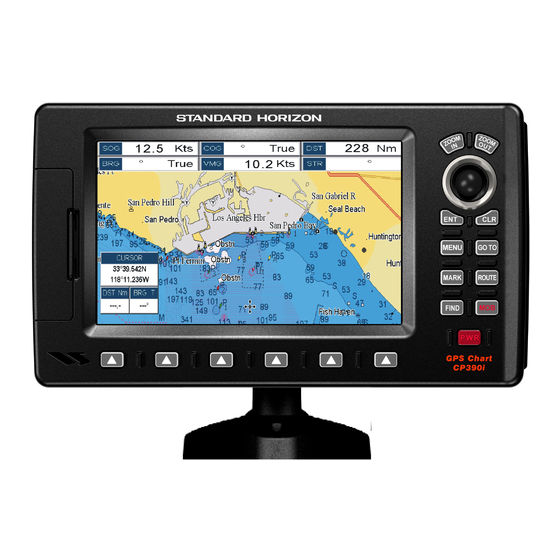
- Page 2 CP390i - GPS Chart Plotters CPF390i - GPS Chart Plotters/Fish Finder Owner's Manual WAAS 3D CP390i CPF390i...
- Page 3 Consult an authorized STANDARD HORIZON dealer or other qualified service technician if the problem cannot be corrected. Operation is subject to the following...
- Page 4 - The GPS Chart Plotter contains dangerous high-voltage circuits which only experienced technicians can handle. - STANDARD HORIZON will not be liable for errors contained herein, or for incidental or consequential damages in connection with the performance or use of this material.
- Page 5 Page CP390i and CPF390i...
-
Page 6: Table Of Contents
CONNECTIONS ..................... 20 2.4.0 CP390i Connection Table ................21 2.4.1 CP390i Connections .................. 21 2.4.2 CPF390i Connection Table ................ 23 2.4.3 CPF390i Connections ................23 BATTERY CONNECTIONS ................... 24 NMEA CONNECTIONS ..................24 GPS POSITION ON A VHF RADIO ............... 25 CP390i: OPTIONAL BLACK BOX FISH FINDER .......... - Page 7 DELETING A MOB POINT ..................75 9. ROUTES ........................... 77 CREATING A ROUTE USING WAYPOINTS ............77 CHANGING THE NAME OF A ROUTE ..............78 CREATING AN OLYMPIC ROUTE ................ 78 MAKING ADDITIONAL ROUTES ................79 Page CP390i and CPF390i...
-
Page 8: Cp390I And Cpf390I Page
12.5.1 Setup Menu ....................104 12.6 NMEA DISPLAY PAGE ..................105 12.7 NMEA DATA PAGE ....................105 12.8 NMEA TREND PAGES ..................106 12.9 VHF DIGITAL SELECTIVE CALLING ..............107 12.9.0 Interfacing ....................108 12.9.1 Distress Call ..................... 108 CP390i and CPF390i Page 9... - Page 9 17.2.2 200 kHz and 50 kHz Zoom Pages ............133 17.2.3 200 kHz and 50 kHz Fish/Chart Pages ........... 134 17.2.3.0 Focus Soft Key on FISH/CHART Page ........134 17.2.4 Radar Pages .................... 134 17.2.4.0 Fish/Radar/Chart Page ............. 134 Page 10 CP390i and CPF390i...
- Page 10 17.16 RESTORE CURRENT PRESET DEFAULTS ............145 18. TROUBLESHOOTING ....................147 19. TECHNICAL TESTS ...................... 149 19.0 SYSTEM TEST ....................149 19.0.0 RAM Menu (reset) ..................149 19.0.1 DIM Menu ....................149 19.0.2 Cartridges ....................150 19.0.3 Serial Ports ....................150 CP390i and CPF390i Page 11...
- Page 11 20. SPECIFICATIONS ....................151 20.0 CP390i/CPF390i SPECIFICATIONS ..............151 20.1 CPF390i FISH FINDER SPECIFICATIONS ............151 20.2 CP390i/CPF390i DIMENSIONS ................152 20.3 OPTIONAL FF525 FISH FINDER SPECIFICATIONS (use with CP390i) ... 152 20.4 OPTIONAL WAAS GPS RECEIVER SPECIFICATIONS ........153 21.
-
Page 12: Introduction
800/767-2450 or marinetech@vxstdusa.com. GENERAL INFORMATION The CP390i (with internal GPS antenna) and CPF390i (with internal GPS antenna and Fish Finder) are precision-crafted high-performance receivers for the Global Positioning System (WAAS GPS) constellation of satellites that provide precise location data with a host of navigation features and are ideal for nautical use and sealed against water ingress. -
Page 13: Packing List
When the package containing the Navigation device is first opened, please check for the following contents. If any parts are missing contact the dealer this Navigation device was purchased from. Accessories and replacement parts may be ordered from STANDARD HORIZON’s Parts Department at 741/827-7600 extension 6800 or e-mail at yaesuparts@vxstdusa.com. 1.1.0... -
Page 14: Optional Accessories
600W 2" Bronze Thru-hull depth temp Transducer DST525 600W In-hull Transducer DST526 600W 2" Bronze Thru-hull depth, speed temp Transducer (FF525 ONLY) DST527 1000W In-hull depth Transducer FF525 ONLY DST528A 1000W Bronze long stem depth temp Transd. CP390i and CPF390i Page 15... - Page 15 Page 16 CP390i and CPF390i...
-
Page 16: Installation
The CP390i and CPF390i are designed to be bracket and flush mounted. However when bracket mounting the CP390i and CPF390i in an area where satellite reception is not possible with the internal antenna or when flush mounted, the optional GPS antenna must be installed. -
Page 17: Flush Mounting
Figure 2.1 - Example of Bracket installation FLUSH MOUNTING The CP390i and CPF390i are supplied with a flush mount template for the cutout hole and screw holes required to install the GPS Chart Plotter. NOTE Before drilling holes make sure there is enough room to mount the GPS Chart Plotter and there are no obstructions. -
Page 18: Mounting The Optional External Gps Antenna
MOUNTING THE OPTIONAL EXTERNAL GPS ANTENNA An external WAAS GPS antenna is available when the CP390i and CPF390i is flush mounted or mounted in an area where satellite reception is not possible with the internal antenna.This antenna is designed to be mounted on a base, installed on an extension or... -
Page 19: Connections
Battery Ground CONNECTIONS The CP390i and CPF390i have connectors that allow them to be connected to a power supply, optional WAAS GPS antenna, optional FF525 50/200kHz BLACK BOX FISH FINDER (only for CP390i) and NMEA Devices* such as Optional Video Camera, VHFs, AIS Receiver, Digital Instruments and autopilots. -
Page 20: Cp390I Connection Table
Yellow *NOTE RS232 not opto-isolated electrical interface. 2.4.1 CP390i Connections 2.4.1.0 DC Power Connection Optional WAAS GPS Antenna ACC 2 Cable - Not used CP390i Switch Black Battery Fuse PWR & ACC 1 Cable 10-35Vdc CP390i and CPF390i Page 21... - Page 21 Input Port operates at 38400 baud and the Output Port is disabled. NOTE* RS232 not opto-isolated electrical interface. 2.4.1.2 AIS Setup The CP390i has to be set up to be able to receive NMEA information from the AIS receiver. Page 22 CP390i and CPF390i...
-
Page 22: Cpf390I Connection Table
[ENT] or move the ShuttlePoint knob to the right. 5. Move the ShuttlePoint knob up/down to select AIS 38400 and press [ENT] or move the ShuttlePoint knob to the right. 2.4.2 CPF390i Connection Table 12VDC Power Pin Wire Color Description Connection Example... -
Page 23: Battery Connections
Input and Output both operate at 38400 baud. 2.4.3.2 AIS Setup The CPF390i has to be set up to be able to receive NMEA information from the AIS receiver. The GPS Chart Plotter reads the AIS NMEA message VMD, type 1, 2, 3 and 5. Select the used port and transmission speed by following the procedure: 1. -
Page 24: Gps Position On A Vhf Radio
* Connect to NMEA Output (if available) * Some manufacturers of DSC VHF’s are not capable of outputting NMEA DSC and DSE sentences to the CP390i or CPF390i. Refer to the Owner’s Manual and confirm the VHF can output NMEA DSC and DSE sentences. -
Page 25: Personal Computer Connections
GPS Chart Plotter is connected to. Example: A VHF radio is connected but the radio is not receiving a GPS Position. Usually the VHF radio will be connected to the Green and Brown wires. To check to see if the GPS Chart Plotter is transmitting the sentences: Page 26 CP390i and CPF390i... -
Page 26: Cpf300I Video Input
2.12 CPF300i VIDEO INPUT By accessing this menu it is possible to see images on the CP390i or CPF390i display from an external video signal source, if connected to the CP390i or CPF390i. It allows the "picture-in-picture" functionality, so a Video Input image can be shown on a window and placed over the Chart, Navigation, Highway, Celestial and NMEA pages image at full screen. - Page 27 See next section for details of setting up the switching times. If the user agrees to proceed, the image from the Video Input and the CP390i or CPF390i page will be shown intermittently. The intermittence time is selected by Switching Timeout item.
-
Page 28: Demo Mode (For Dealer Use)
Full page, Radar page, Navigation page, Highway Page, Celestial page, NMEA Display page. NOTE This mode is used by dealers to promote the features of the CP390i or CPF390i when on a retail shelf. The Demo mode can be selected from the Simulation Menu following the procedure: 1. - Page 29 Page 30 CP390i and CPF390i...
-
Page 30: Controls And Indicators
CONTROLS AND CONNECTIONS The CP390i or CPF390i is controlled by using the keys located on the front panel. These labeled keys are dedicated to specific functions. As you press a key, a single audio beep confirms the key action; every time a key press is not valid, three rapid beeps sound to indicate that the key action is not valid. -
Page 31: The Soft Keys
[CLR]. GETTING STARTED The Getting Started section will take you through the frequently used operations and assist you to customize the look of the GPS Chart Plotter. Page 32 CP390i and CPF390i... -
Page 32: Power On, Off And Shuttlepoint Knob Operation
GPS Chart Plotter Software V16.30 00R Figure 3.1.0 - Example of Start-Up page on CPF390i 2. When the power is first turned on two pages the start-up page and the Caution pages are briefly shown before the GPS Status page. -
Page 33: Cursor Vs. Home Mode
To change from Cursor Mode to Home Mode press [CLR]. 3.1.2 Cursor and Menu selection speed The CP390i and CPF390i allow you to control the speed the Cursor moves when the ShuttlePoint knob is pressed. To change the speed: Figure 3.1.2 - Cursor Speed menu... -
Page 34: Changing The Ship Icons
3.1.4 Changing the backlight and contrast With the CP390i and CPF390i turned on, briefly press [PWR] to show the backlight and contrast popup window. Move the ShuttlePoint knob to the left or right to adjust the LCD backlight intensity or up or down to change the LCD contrast. Press [ENT] to set. -
Page 35: Selecting North Up Or Course Up
5. Press [CLR] or move the ShuttlePoint knob to the left to exit the menu and show the Chart page. NOTE When the CP390i and CPF390i are in Course Up mode a small arrow icon will be shown on the Chart page indicating North. - Page 36 6. Next move the ShuttlePoint knob to highlight DAYLIGHT SAVING and press [ENT] or move the ShuttlePoint knob to the right. 7. Daylight Saving menu has 3 options: 7.1 OFF Select Off when your location does not recognize Daylight Savings Time; CP390i and CPF390i Page 37...
-
Page 37: Selecting Loran Td Or Other Coordinate System
Example: Y/Z change to Z/Y. CHANGING THE CHART COLOR The CP390i and CPF390i have preprogrammed settings allowing you to customize the look of the Chart page. The default is Sunlight, however there are other settings: Classic, NOAA, Night and Normal. Night is very useful during evening hours so not to impair night vision. -
Page 38: Selecting Language
Point knob to the desired language and press [ENT] or move the ShuttlePoint knob to the right. 5. Press [CLR] or move the ShuttlePoint knob to the left to exit the menu and show the Chart page. CP390i and CPF390i Page 39... -
Page 39: Selecting Pages Using Soft Keys
GPS STATUS NMEA DISPLAY Display example with RADAR connected Chart 200KHz WAAS Figure 3.6 - Screen display pages CUSTOMIZING THE SOFT KEYS The Soft Keys can be individually customized from the default pages (discussed above) to Page 40 CP390i and CPF390i... -
Page 40: Settings In General Setup Menu
The GPS Chart Plotter displays charts and screen in darker colors. SunLight (default) is designed to enhance the visibility of the screen when the GPS Chart Plotter is exposed to sunlight. The charts are much brighter than in the CP390i and CPF390i Page 41... - Page 41 By default when the cursor is moved a window is shown with the Lat/Lon Distance and Bearing from the vessels location to the cursor. This selection allows the window to be turned On (default) or Off. The Cursor Window is automatically disabled when General is set in Windows Setup option. Page 42 CP390i and CPF390i...
-
Page 42: About Page
ShuttlePoint knob to the right. 3. The Information page appears on the screen (see the previous Figure). 4. Press [CLR] or move the ShuttlePoint knob to the left to exit and show the Chart page. CP390i and CPF390i Page 43... - Page 43 Page 44 CP390i and CPF390i...
-
Page 44: Find Services
FIND SERVICES USING FIND SERVICES & MORE FUNCTIONS The CP390i and CPF390i have a dedicated [FIND] key that allows searching the optional C-MAP B /MAX C-CARD for Port Services, Ports, Tide Stations, Wrecks, EPPESEN Obstructions, Points Of Interest, Lakes, User Points, GPS Coordinates or Information on any point on the Chart. -
Page 45: Port
4. Move the ShuttlePoint knob to highlight the desired Tide Station and press [ENT]. 5. Another window will be shown detailing the selected Tide Station information. 6. Press [CLR] to show the actual position of the Tide Station on the Chart Page. Page 46 CP390i and CPF390i... -
Page 46: Wrecks
Figure 4.0.3 - Wreck icons Table 1. Press [FIND]. 2. Move the ShuttlePoint knob to highlight WRECKS and press [ENT] or move the ShuttlePoint knob to the right. CP390i and CPF390i Page 47... -
Page 47: Obstructions
5. Another window will be shown detailing the Obstruction information. 6. Press [CLR] to show the actual position of the Obstruction on the Chart page. 7. Press [CLR] again at any time to return your cursor to your vessel’s position. Page 48 CP390i and CPF390i... -
Page 48: Lakes Information
4.0.5.0 Quick Info On Lakes Upon viewing the chart of a lake, you can click on the Lake Info icon to query the available information immediately displayed with many details. For example, see the following picture: CP390i and CPF390i Page 49... - Page 49 Figure 4.0.5.1 - Example of Full Info page To see the "Fishing" object press [MENU] (when the "Fishing" object is highlighted). On the screen appears: Figure 4.0.5.1a - Example of picture associated to the Fishing object Page 50 CP390i and CPF390i...
-
Page 50: Lakes By Name
9. Another window will be shown with detailing the Point Of Interest information. 10. Press [CLR] to show the actual position of the Point Of Interest on the Chart Page. 11. Press [CLR] again at any time to return your cursor to your vessel’s position. CP390i and CPF390i Page 51... -
Page 51: User Points
2. Move the ShuttlePoint knob to highlight COORDINATES and press [ENT] or move the ShuttlePoint knob to the right. 3. A (Coordinate) popup window will be shown to allow you to enter in a specified Latitude and Longitude. Page 52 CP390i and CPF390i... -
Page 52: Information
ShuttlePoint knob through the Info Tree, all the relevant information of the selected object is shown on the lower part of the page. 4. Press [CLR] again at any time to return your cursor to your vessel’s position. Figure 4.0.10 - Find Information CP390i and CPF390i Page 53... - Page 53 Page 54 CP390i and CPF390i...
-
Page 54: Max Cartography Overview
This Chart Update Card may be used ONE time to update the charts in a GPS Chart Plotter. After the updating, the Chart Update Card will not update other GPS Chart Plotters. After purchasing the Chart Update Card, follow the procedure below to update the charts. CP390i and CPF390i Page 55... -
Page 55: Inserting The Optional Max C-Card
Open the door, gently push the C-CARD into the slot: push the C-CARD in as far as it will go, then close the door. Figure 5.1a - Inserting C-CARD (details) NOTE The small connector below the C-CARD is only used by Standard Horizon repair technicians. Page 56 CP390i and CPF390i... - Page 56 · Safety Status Bar (a status bar with six boxes to show the status of certain functions. Any warning or alarm condition is identified by the red color to indicate possible risk) CP390i and CPF390i Page 57...
- Page 57 MAX data cover different areas, the GPS Chart Plotter receives data from both charts (depending on the current position). · When NT data and MAX data cover the same area, the GPS Chart Plotter receives data only from MAX chart. Page 58 CP390i and CPF390i...
-
Page 58: Map Functions
[ZOOM IN]/[ZOOM OUT] push (press and hold) causes an expansion or compression of the chart image, without a chart level change. CHART: US,NOS,GRAPH,11428D SCALE: 1:40000 CHART: US,NOS,GRAPH,11428D SCALE: 1:40000 CHART: US,NOS,GRAPH,11474 SCALE: 1:80000 Figure 6.0.0 - Zoom Type CP390i and CPF390i Page 59... -
Page 59: Icon Size
6.0.2 Place Name Size On MAX charts it is possible to set the size of all names drawn on the charts, selecting between Standard (default), Medium and Large size. Page 60 CP390i and CPF390i... -
Page 60: Perspective View
ShuttlePoint knob to the right. 3. Move the ShuttlePoint knob to highlight PERSPECTIVE VIEW and press [ENT] or move the ShuttlePoint knob to the right. 4. The menu now shows two selections, ON or OFF. CP390i and CPF390i Page 61... -
Page 61: Dynamic Nav-Aids
5. Move the ShuttlePoint knob to select the selection and press [ENT]. 6. Press [CLR] until the menu disappears or an easier method is to press the ShuttlePoint knob to the left a few times. Page 62 CP390i and CPF390i... -
Page 62: Satellite Imagery
5. Move the ShuttlePoint knob to select the selection and press [ENT]. 6. Press [CLR] until the menu disappears or an easier method is to move the ShuttlePoint knob to the left until the chart page is shown. CP390i and CPF390i Page 63... -
Page 63: Currents Prediction
To activate this function follow the procedure: 1. Press [MENU], move the ShuttlePoint knob to highlight SETUP MENU and press [ENT]. 2. Move the ShuttlePoint knob to highlight MAX FUNCTIONS and press [ENT] or move the ShuttlePoint knob to the right. Page 64 CP390i and CPF390i... -
Page 64: Chart Language
] to exit. 6.0.8 Chart Language The CP390i and CPF390i may be customized to show the local language of the chart. To select the Chart Language you want: 1. Press [MENU], move the ShuttlePoint knob to highlight SETUP MENU and press [ENT]. -
Page 65: How To Show The Pictures Or Diagrams Of A Object
When the picture is shown, it is possible to fit it to screen by pressing [ENT], to change the contrast by pressing [ZOOM IN] or [ZOOM OUT] and to display the next picture associated, if any, by moving the ShuttlePoint knob left or right. Page 66 CP390i and CPF390i... -
Page 66: Enhanced Port Info
Additional attributes of Port Areas and Port Marinas have been included as Location, Country, Region, State, Harbour master telephone number etc., see the following figure. WAAS 3D PORT icon Figure 6.0.10 - Example of enhanced Port Info CP390i and CPF390i Page 67... - Page 67 Page 68 CP390i and CPF390i...
-
Page 68: Creating Marks
If a Mark has previously been created and you wish to Edit it, move Cursor over the top of the Mark. 1. After a Mark is created press [E ] to show the edit popup window. CP390i and CPF390i Page 69... -
Page 69: Deleting A Mark Or Waypoint
1. Move the ShuttlePoint knob over the Mark or Waypoint you want to move. 2. Press [M 3. Use the ShuttlePoint knob to move the cursor. A dotted line, connecting the previous Waypoint position to the new position, is shown: Page 70 CP390i and CPF390i... -
Page 70: Marks/Waypoints List
When selected, receives points from an external device (PC) that is capable of sending NMEA WPL sentence. NOTE* The SEND and RECEIVE functions are used to receive or transmit User Points (Marks and Waypoints) to and from a Personal Computer (see also Par. 2.9). CP390i and CPF390i Page 71... -
Page 71: Creating A New Mark With The User Points List
18. Press [CLR] again and the new Mark appears on the Chart page. WARNING After entering in all the Marks it is a good practice to backup the points to a User C-CARD. Refer to Section 11. Page 72 CP390i and CPF390i... -
Page 72: Goto Cursor, Route And Mark
GOTO CURSOR, ROUTE AND MARK The CP390i and CPF390i can easily be set to start navigating to the Cursor on the chart page, a saved Mark or a Route that was created. GOTO CURSOR 1. Move the ShuttlePoint knob to the exact position you want to navigate to. - Page 73 5. You will notice a circle is drawn around the Icon Symbol. This means the GPS Chart Plotter is now navigating to the point. 6. Press [CLR] to switch to the Chart page or Highway page to start navigating to the point. Page 74 CP390i and CPF390i...
-
Page 74: Man Over Board (Mob) Function
During navigation, the “MOB” feature provides a one-touch method of storing a location, such as a point were a crew member fell overboard. In this mode, the CP380i or CPF390i places a MOB point on the Chart page and all the navigation data shown is related to navigating back to this point, allowing you to retrace your path to the MOB point efficiently. - Page 75 Page 76 CP390i and CPF390i...
-
Page 76: Routes
ROUTES The CP190i and the CPF390i have the capability to store 50 Routes with 100 Waypoints or Marks in each Route. A Route can consist of Waypoints or Marks. The difference is when a Route is made using Waypoints and the Route is deleted the Waypoints are also deleted. -
Page 77: Changing The Name Of A Route
4. Press [ROUTE]. Another Waypoint is shown under the cursor and a line joins the starting Waypoint to the second Waypoint. 5. Repeat steps 3 and 4 until all Waypoints are entered into the Route. 6. Then move the ShuttlePoint knob to the last Waypoint. Page 78 CP390i and CPF390i... -
Page 78: Making Additional Routes
4. Repeat steps 3 and 4 until all Marks are entered into the Route. NOTE At this point the Route is saved as ROUTE01. If you would like to save the Route under a specific name follow the remaining steps. CP390i and CPF390i Page 79... -
Page 79: Inserting A Waypoint Into A Route
1. Move the ShuttlePoint knob to an open position (no buoy, warning etc. under the cursor) on the Chart page. 2. Press [GOTO] to show the GOTO popup window. 3. Move the ShuttlePoint knob to highlight ROUTE and press [ENT]. Page 80 CP390i and CPF390i... -
Page 80: Using The Shuttlepoint Knob
4. A Warning message appears to confirm. Move the ShuttlePoint knob to highlight YES and press [ENT]. The Route has been deleted. WARNING An active Route (one that you are navigating to) cannot be deleted until you stop navigating to the Route. CP390i and CPF390i Page 81... -
Page 81: Other Settings In Route Menu
The Route Check function is used after you have created a Route to ensure you and your vessel will not have problems while navigating. This is done by the CP390i and CPF390i by reviewing the Route and looking for the following hazards that may effect safe navigation. -
Page 82: Cp390I And Cpf390I Page
(like DSC, MOB, Mark). In the case of checking a single point towards which the navigation is started, the leg for which the Route Check is executed is defined by the current position (the leg’s starting point) and the destination point (the leg’s ending point). CP390i and CPF390i Page 83... - Page 83 Page 84 CP390i and CPF390i...
-
Page 84: Tracks
The Track function can be setup to lay down a Track for a predetermined time or distance interval. If you have a fast moving boat you may want to setup the CP390i or CPF390i to record a Track point every 0.5NM or if you have a sail boat you may want to setup to lay down a Track point once every 1 minute. -
Page 85: Saving And Starting A New Track
Shows or hides a Track shown in ACTIVE TRACK menu LINE COLOR Selects the color of the Track line DELETE Deletes a Track selected in the ACTIVE TRACK menu STEP UNIT Allowable selection are Distance or Time Page 86 CP390i and CPF390i... -
Page 86: Trip Log
5. A warning popup window will be shown to confirm if you want to reset the Trip Log. Move the ShuttlePoint knob to highlight YES and press [ENT].The Trip Log is now reset. 6. Press [CLR] to store and exit the editing mode WAAS 3D Figure 10.1. 1 - Trip Log Reset CP390i and CPF390i Page 87... - Page 87 Page 88 CP390i and CPF390i...
-
Page 88: User C-Card
Formatting permanently erases all files previously saved on the User C-CARD. 11.0.1 Transferring files to the optional User C-CARD 1. Remove a C-CARD if present and insert the optional C-MAP B /MAX EPPESEN User C-CARD into the slot. CP390i and CPF390i Page 89... -
Page 89: Loading A File From The Optional User C-Card
3. Open the door, remove the User C-CARD from the slot and insert another User C-CARD into the same slot. 4. Move the ShuttlePoint knob to highlight REFRESH and press [ENT]. This "new" User C-CARD is now ready to receive and store information. Page 90 CP390i and CPF390i... -
Page 90: Pages
12. PAGES The CP390i and CPF390i have many pages that are designed to ease your navigation. CHART NAVIGATION WAAS 3D HIGHWAY WAAS 3D CELESTIAL WAAS 3D GPS STATUS NMEA DISPLAY WAAS 3D CHART and FISH FINDER Display example with RADAR CONNECTED... -
Page 91: Chart Page
Dual Chart page. It happens when the GPS Chart Plotter updates the displayed chart in the not active window. So the user understands that the GPS Chart Plotter is busy. Page 92 CP390i and CPF390i... -
Page 92: Focus Soft Key On Dual Chart Page
Figure 12.0.0a - Example of Dual Chart page with [F ] window shown OCUS 3. Move the ShuttlePoint knob up and down to highlight the desired item and press [ENT]. The red boarder is moved to the focused window. CP390i and CPF390i Page 93... -
Page 93: Single Chart Page
Distance & Bearings from Fix to Cursor Figure 12.0.1 - Example of Single Chart Page 12.0.2 Window Selections The default is the Two Line Small window. The CP390i and CPF390i windows may be changed by the procedure below. COMPASS GENERAL... -
Page 94: Customizing The Data Windows
[ENT]. The popup window will be shown. 3. Move the ShuttlePoint knob up/down or left/right to choose the desired setting and press [ENT]. 4. Press [CLR] to store and exit the editing mode. CP390i and CPF390i Page 95... -
Page 95: Additional Functions On Chart Page
4. Move the ShuttlePoint knob up or down to highlight OFF, ON POINTS or ON ALL and press [ENT] or move the ShuttlePoint knob to the right. 5. Press [CLR] or move the ShuttlePoint knob to the left until the Chart page appears. Page 96 CP390i and CPF390i... -
Page 96: Display Mode
The table below shows the selections for each mode: Setting Full Medium Radar Tides Custom (Default values) Place Names Name Tags Nav Aids & Light Sectors No Sectors No Sectors No Sectors Attention Areas Tides & Currents CP390i and CPF390i Page 97... -
Page 97: Marine Settings
Depth Range Min : Sets the minimum depth limit to show Depth Sounding, Bathymetric Lines and Depth Area. Depth Range Max : Sets the max depth limit to show Depth Sounding, Bathymetric Lines and Depth Area. Page 98 CP390i and CPF390i... -
Page 98: Land Settings
Each box indicates an area where more detail is available. The Chart Boundaries are only show when a C-MAP B or MAX CARD is inserted into the GPS EPPESEN Chart Plotter. See the pictures below: CP390i and CPF390i Page 99... -
Page 99: Underwater Objects Settings
Sets Off/Icon/Icon+Depth* the displaying of Diffusers (Diffuser is a structure on an outfall through which liquids are discharged. The structure will usually project above the level of the outfall and can be an obstruction to navigation). Wrecks Sets Off/Icon/Icon+Depth* the displaying of Wrecks. Page 100 CP390i and CPF390i... -
Page 100: Customizing Chart Settings
6. Press [CLR] or move the ShuttlePoint knob to the right until the Chart page is shown. Fix position Time 3 Speed Over Ground WAAS 3D Course Over Ground Bearing to Destination Time To Go Distance to Destination Compass Rose Figure 12.2 - Navigation page with Compass Rose CP390i and CPF390i Page 101... -
Page 101: Highway Page
1. Press [ENT] and a popup window will be shown. 2. Moving the ShuttlePoint knob up or down changes the digits and left and right selects the month, day and year. 3. Press [CLR] to exit and view the information. Page 102 CP390i and CPF390i... -
Page 102: Gps Status Page
This page is used as a reference to see how well the GPS is receiving satellites. Ship’s Coordinates Date and Time WAAS/GPS Icon WAAS DATE Vertical Dilution of Precision 10/25/10 Horizontal Dilution of Precision Tracked, but not used, Satellite Used Satellite (Course Over Ground) Figure 12.5 - GPS Status page CP390i and CPF390i Page 103... -
Page 103: Waas/Egnos Setting
Move the ShuttlePoint knob to highlight the preferred item and press [ENT]. Press [CLR] until the menu disappears or an easier method is to move the ShuttlePoint knob to the left until the menu disappears. Page 104 CP390i and CPF390i... -
Page 104: Nmea Display Page
GPS Chart Plotter NMEA output is being loaded down by a external NMEA device the GPS Chart Plotter is connected to. Scenario: VHF Radio connected but the Radio is not receiving a GPS Position. CP390i and CPF390i Page 105... -
Page 105: Nmea Trend
Trends will be shown for Depth, Temp and Speed (DST521 or DST526 must be connected to show speed through the water) when a Standard Horizon transducer is connected. To show Wind trend information the CP390i and CPF390i must be connected to the NMEA output of a external Wind instrument. -
Page 106: Vhf Digital Selective Calling
GPS Chart Plotter which feeds GPS data to the VHF and listens for DSC calls from the VHF. By connecting a few wires between the compatible DSC VHF radios and the GPS Chart Plotter it will receive: 1. a vessel that has transmitted a DSC Distress call CP390i and CPF390i Page 107... -
Page 107: Interfacing
For additional information refer to Par. 2.4 Connections. 12.9.1 Distress Call STANDARD HORIZON GPS chart plotters are able to display the location of a vessel in distress when interfaced to a compatible DSC VHF with NMEA 0183 output and the radio receives a DSC Distress Call. - Page 108 03-03-01 33°30.505 PINKO 08:31 PM 118°18.529 0080457645 33°34.167 03-04-01 118°21.864 0023244524 00:11 PM 33°31.211 BOBI 03-04-01 09:31 PM 118°29.151 0056477743 Figure 12.9.2 - DSC Log - Position Request CP390i and CPF390i Page 109...
- Page 109 Page 110 CP390i and CPF390i...
-
Page 110: Advanced Settings
13.0 INPUT/OUTPUT (NMEA, AIS, RADAR) 13.0.0 Input The CP390i has 4 Inputs and 5 Outputs connections. The CPF390i has 3 Inputs and 3 Outputs connections. These ports may be set up to receive and output the following. · NMEA-0183 - NMEA devices* set to 4800 Baud (default setting) ·... -
Page 111: Navigate
Degrees Minutes and Seconds (default) Chart Datum : Allows selection of Chart Datums. The default Datum is WGS84 as C-MAP B EPPESEN cartography has been compiled using the WGS84 Datum. A datum is a mathematical Page 112 CP390i and CPF390i... -
Page 112: Loran Td
Calibration : This function allows a user to enter in the offset for areas that the vessel may cruise instead of entering in a manual offset for one location. This offset is useful for cruising vessels or vessels that travel internationally often. Figure 13.2 - Compass Table CP390i and CPF390i Page 113... -
Page 113: Alarms
The GPS Chart Plotter shows an icon on the charts that identifies when a Grounding Alarm is detected. Figure 13.3 - Grounding Alarm 13.4 SIMULATION The built-in Simulator function allows you to become proficient in the use of the GPS Chart Page 114 CP390i and CPF390i... -
Page 114: Navigating A Route In Simulation Mode
The cursor is moved to the point “P” and shows the point in the center of the screen; 3 : when moving the cursor from “P”, the location can be confirmed. At this time, the same MMSI Position Request data that were received before are remaining and displayed. CP390i and CPF390i Page 115... - Page 115 Manual. If Auto Info is set to On, when receiving the Position Request it is possible to center the cursor over the top of the Position Request icon and show the Position Request popup window Page 116 CP390i and CPF390i...
-
Page 116: Ais
· Receive details from other vessels or navigation aids within VHF range. STANDARD HORIZON GPS Chart Plotters are able to display AIS target (for collision avoidance) on the Chart Page and AIS list pages when connected to a AIS receiver (GX2100 or GX2150 STANDARD HORIZON VHF/AIS transceiver) or transponders which output NMEA 0183 VDM sentence at 38400 or 4800 baud. -
Page 117: Menu
By placing the cursor over a AIS Target icon using the ShuttlePoint knob, the following information is displayed (see the following picture): · Vessel Name · MMSI number · Radio Call Sign · SOG · COG · CPA and TCPA values Page 118 CP390i and CPF390i... -
Page 118: List
GPS Chart Plotter. 14.5 AIS TARGET COLORS The received AIS Targets are shown in color. The color depicts the type of AIS ship shown on the Chart Page. Refer to following table. CP390i and CPF390i Page 119... - Page 119 Vessels with antipollution facilities or equipment (light blu) Low enforcement vessels (light red) Medical transport (dark green) Vessels according to Resolution N 18 (Mob-83) (cyan) (red) Passenger ship (magenta) Cargo ship (dark gray) Figure 14.5 - Color AIS Targets Page 120 CP390i and CPF390i...
-
Page 120: C-Weather Service
15. C-WEATHER SERVICE C-Weather is a free service available on the CP390i and CPF390i. C-Weather service gives excellent coverage for the whole World. Weather forecasts are based on data received from the leading meteorological centers. This data is processed by Jeppesen server and made... -
Page 121: Copy From User C-Card
· Real Time View Off: the Weather data is not displayed. The layer displayed is the one selected into the previous menu item. 15.0.4 Type of Data Allows selecting the type of data, refer to the table in the Figure 15. Page 122 CP390i and CPF390i... -
Page 122: Mobilarm
16.0 MOBILARM-GPS CHART PLOTTER CONNECTION Connect the MOBILARM system to one of the Ports on the Standard Horizon GPS Chart Plotter. Refer to Par. 2.4.0 “Connection Table” for CP390i, Par. 2.4.2 “Connection Table” for CPF390i and MOBILARM Owner’s Manuals for connections. -
Page 123: Software Setup
NOTE Note the CP390i and CPF390i have 3 Ports so Port 1, 2 or 3 can be be used. Port 1 Example Chart Plotter MOBILARM Blue NMEA Out Brown NMEA In GPS V+ Black GPS V- NOTE Refer to the Figure 16.0, the Blue and Brown wires are from Port1. If these wires are being used to connect to another NMEA device, choose another wire pair and configure the port associated with the wires. -
Page 124: Mobilarm Ptx
On the GPS Chart Plotter all menus and/or pages are closed and the chart is centered on the PTX MOB received position. A Audible Alarm is heard and a pop-up warning window appears to notify that a PTX has been received: CP390i and CPF390i Page 125... -
Page 125: Placing Cursor On The Ptx Icon
Using the ShuttlePoint knob, move the cursor over the PTX icon and then press [D ELETE A warning pop-up window will be shown. Select YES and press [ENT]. 16.4.1 Goto PTX When Goto is selected on the GPS Chart Plotter, navigation will start to the PTX icon Page 126 CP390i and CPF390i... -
Page 126: The Mobilarm Alarm Status List
1. Select the Chart Page. 2. Press [MENU] to show the Main menu. 3. Move the ShuttlePoint knob to highlight USER POINTS and press [ENT]. 4. Move the ShuttlePoint knob to highlight MOBILARM and press [ENT]. CP390i and CPF390i Page 127... - Page 127 (if open) and center the chart selected PTX. DELETE Deletes the selected PTX. SHOW Centers the chart on the selected PTX. SHOW ALL Selects the best chart scale to see al PTX icons on the chart at the same time. Page 128 CP390i and CPF390i...
-
Page 128: Fish Finder
4. Move the ShuttlePoint knob to highlight FISH FINDER and press [ENT] or move the ShuttlePoint knob to the right. 5. Move the ShuttlePoint knob up/down to select OFF and press [ENT] or move the CP390i and CPF390i Page 129... -
Page 129: Understanding The Fish Finder Page
17.1 UNDERSTANDING THE FISH FINDER PAGE The display on CPF390i shows a time history of the echoes received by the transducer. The CPF390i have a menu that allows adjustments to receiver sensitivity, depth range and scrolling speed of the Fish Finder display. -
Page 130: Understanding The Fish Finder Display
Are the zones where two layers of different water temperatures meet. The greater the temperature differential, the denser the thermocline shows on the screen. Thermo- clines are represented as horizontal stripes of noise. They are very important for fishing CP390i and CPF390i Page 131... -
Page 131: Displaying The Fish Finder Page
1. From all pages (except the Fish Finder page), press [MENU]. From Fish Finder page, press [MENU] two times. Figure 17.2 - Main Menu 2. Move the ShuttlePoint knob to highlight FISH FINDER and press [ENT]. Figure 17.2a - Fish Finder page selection menu Page 132 CP390i and CPF390i... -
Page 132: Auto Full Page
To select the area to be zoomed in move the ShuttlePoint knob Up or Down which moves the VRM line. To zoom In or Out, press [ZOOM IN] or [ZOOM OUT]. The zoom ranges are 2x and 4x the normal Fish Finder display. Figure 17.2.2 - Zoom Full page CP390i and CPF390i Page 133... -
Page 133: 200 Khz And 50 Khz Fish/Chart
Marker can be moved to see the depths of targets and Fish Finder menus can be accessed. 17.2.4 Radar Pages 17.2.4.0 Fish/Radar/Chart Page Selects the GPS Chart Plotter display to show the Chart, the Fish Finder and the Radar page on the screen. Page 134 CP390i and CPF390i... -
Page 134: Radar Combo Page
Figure 17.2.4.2 - Example of Combo page with [F ] shown OCUS 3. Move the ShuttlePoint knob to highlight the desired window and press [ENT]. The red boarder is moved to the focused window. CP390i and CPF390i Page 135... -
Page 135: Soft Key Operation
This section explains how to show the Fish Finder Setup menu and describe the Fish Finder Setup menu sub-options. 1. From the Full Fish Finder page, press [MENU]. The following menu appears: Figure 17.4 - Fish Finder Setup menu Page 136 CP390i and CPF390i... -
Page 136: Presets
For Range and Shift settings refer to Range menu (see Par. 17.8). 17.6 FREQUENCY Allows you to choose the frequency among Auto, 50 kHz, 200 kHz or 50&200 kHz when single frequency page is selected. Figure 17.6 - Frequency menu CP390i and CPF390i Page 137... -
Page 137: Gain Mode
The Fish Finder determines automatically the Range as to keep the bottom visible in the lower bottom of the screen. In this mode, Shift is always set to 0. 17.8.0.2 Bottom Lock The Bottom Lock function keeps the screen display locked onto a certain Range around the Page 138 CP390i and CPF390i... -
Page 138: Depth
Turns On or Off a filter to remove noise from other Fish Finder or Depth Sounders that may be near by when fishing. 17.10 SENSITIVITY MENU All settings in the Sensitivity menu are related to the selected Fish Finder transmit frequency (50 or 200kHz). CP390i and CPF390i Page 139... -
Page 139: Gain
One indication that the STC needs to be changed is when the display intermittently changes the depth from the correct depth to a very shallow depth. Figure 17.10.1 - STC - Surface Clutter The STC can be changed from Short, Mid, Long and Custom. Page 140 CP390i and CPF390i... -
Page 140: Surface Noise Filter
8 the attenuation is maximum and is applied from surface level down to a depth of 255 Ft, as shown in the Surface Noise Filter Table reported below: CP390i and CPF390i Page 141... -
Page 141: Display Setup
Controls how the bottom type (hard or soft) is shown on the display. When the White Line is Off the bottom return will display as red. When the White Line is On it can be used to determine bottom hardness. Page 142 CP390i and CPF390i... -
Page 142: Fish Symbols
Calibrate Water Speed Used to calibrate the Water Speed readings from the transducer. Adjustment can be made from -10% to +10%. 17.12.2 Calibrate Water Temp Used to calibration on the Water Temperature sensor in the transducer. CP390i and CPF390i Page 143... -
Page 143: Set Defaults
Off, Small, Medium, Big and Huge. The alarm sounds if the set size (or bigger) is detected. 17.13.3 Temperature Upper Triggers an alarm when the transducer reports a temperature above the set temperature. 17.13.4 Temperature Lower Triggers an alarm when the transducer reports a temperature below the set temperature. Page 144 CP390i and CPF390i... -
Page 144: Temperature Rate
Card that may be used to backup the User Points and Tracks too). Figure 17.15 - C-CARD - Load settings 17.16 RESTORE CURRENT PRESET DEFAULTS This option restores the default values only for the current presets and does not affect the other presets. CP390i and CPF390i Page 145... - Page 145 Figure 17.16 - C-Card - Restore settings Page 146 CP390i and CPF390i...
-
Page 146: Troubleshooting
Internal RAM memory to become corrupted. To solve this issue, perform a RAM clear (refer to Section 19). NOTE After performing a RAM Clear all Marks, Routes and tracks will be erased. To back up these points refer to Section 11 for details. CP390i and CPF390i Page 147... - Page 147 Page 148 CP390i and CPF390i...
-
Page 148: Technical Tests
Each time you move the ShuttlePoint knob to right, the screen will decrease brightness, move it to the left to increase brightness. Backlight The second option allows to set the backlight. Operates in similar mode as Contrast. CP390i and CPF390i Page 149... -
Page 149: Cartridges
ASCII mode (normal or small) and [CLR] to exit. Loop-Back Test This is a special test done during the production phase to check the serial ports integrity. This function is only required by Standard Horizon. Page 150 CP390i and CPF390i... -
Page 150: Specifications
: 5Feet at 50kHz, 2.5Feet at 200kHz Maximum Depth : 1500Feet at 50kHz, 700Feet at 200kHz Airmar X-DUCER ID : Must use Standard Horizon transducers Advanced Digital Signal Processing Speed & Temperature Sensor (if available on transducer) Alarms (shallow water, depth, Fish, temp) -
Page 151: Cp390I/Cpf390I Dimensions
3.9" [98.6mm] 1.5" 1.5" [37mm] [37mm] 9.9" [251mm] 0.2" [4.1mm] Figure 20.2 - CP390i/CPF390i Dimensions [inch/mm] 20.3 OPTIONAL FF525 FISH FINDER SPECIFICATIONS (USE WITH CP390i) Power Output : 600W or 1kW depending on connected transducer Frequency : 50 and 200kHz Minimum Depth : 5Feet at 50kHz, 2.5Feet at 200kHz... -
Page 152: Optional Waas Gps Receiver Specifications
Reacquisition < 1 second Hot Start 1 second outdoor, 10 seconds indoor Warm Start 29 seconds Cold Start 29 seconds Accuracy < 2.5m with SBAS < 2.0m NMEA Output Messages GGA, RMC, GSA, GSV, TXT CP390i and CPF390i Page 153... - Page 153 Page 154 CP390i and CPF390i...
-
Page 154: Cp390I And Cpf390I Page
GPS3D – The GPS is receiving at least 4 Satellites. HDG (Heading) – Shows heading from a External Flux Gate Compass when connected. HDOP/VDOP – Horizontal/Vertical Dilution of Precision. It is a parameter indicating the CP390i and CPF390i Page 155... - Page 155 70 metres (230FT) in Height and up to 600 metres (2.000 FT) in diameter. Position Request – Marine DSC VHF Function of transmitting a GPS position to another Marine DSC VHF. When GPS Chart Plotter is connected to STANDARD HORIZON GPS the position of another vessel is shown on the Chart page.
- Page 156 WATER TEMP – Shows the sea water temperature for when a Digital Speed Log/Temp instrument with NMEA is connected. XTE (Cross Track Error) – The distance your vessel is off course (left or right) to a Destination point. CP390i and CPF390i Page 157...
- Page 157 Page 158 CP390i and CPF390i...
-
Page 158: Analytical Index
Apparent Wind Direction ..95, 155 Calibrate Water Speed ....143 Apparent Wind Speed ....95, 155 Calibrate Water Temp ..... 143 Arrival Alarm ........114 Calibration ........113 ASF ........... 38 camera icon ........66 CP390i and CPF390i Page 159... - Page 159 ........17, 31 Deleting a Mark ......... 70 Coordinate System ......112 Deleting a Waypoint ......70 Coordinate System menu ....38 Deleting file ........90 Coordinates ........ 32, 52 Deleting MOB ........75 Page 160 CP390i and CPF390i...
- Page 160 Fish Finder page ......130 DSC VHF ......... 25, 108 Fish Finder page selection ....132 DSC VHF Radio ........ 24 Fish Finder Setup menu ....136 DSE ........105, 151 Fish Finder window ......130 CP390i and CPF390i Page 161...
- Page 161 Keel Offset ........143 GPS Status page ......103 key ............ 31 GPS2D ........104, 155 Keyboard ......... 151 GPS3D ........104, 155 KEYPAD BEEP ......... 41 Great Lakes ....... 55, 92 Km Kilometer ........156 Page 162 CP390i and CPF390i...
- Page 162 MAX ........... 55, 59 NMEA Input sentences ....151 Max Functions Menu ......59 NMEA Output ........21 Max Speed ........95 NMEA Output sentences ....151 MEASURE DISTANCE ..... 42 NMEA sentences ..... 26, 105 CP390i and CPF390i Page 163...
- Page 163 Port Services ...... 32, 45, 67 Restore settings ......146 Port Services Table ......45 Reverse Route ........82 Ports ..........32 RMA ........112, 151 Ports & Services ....... 98 RMB ........112, 151 Page 164 CP390i and CPF390i...
- Page 164 ShuttlePoint knob ......31 TCPA Alarm ......117, 118 SI-TEX ......14, 41, 111 TCPA Limit ......117, 118 Signals ..........98 TD ........38, 112, 113 SIM Pin ........... 121 technical support ....... 13 CP390i and CPF390i Page 165...
- Page 165 True Wind Speed ..... 95, 156 VWT ........105, 151 True-Type Font ......... 57 TTG .......... 95, 156 turn the GPS Chart Plotter On ... 32, 56 WAAS ....... 19, 95, 153 TWD ..........95 WAAS 2D ........156 Page 166 CP390i and CPF390i...
- Page 166 White Line ......132, 142 ZOOM IN ........... 31 Wind Instrument ........ 24 ZOOM OUT ........31 Wind speed ........105 Zoom Pages ........133 WIND SPEED TREND ..... 41, 107 Zoom Type ........59 CP390i and CPF390i Page 167...
- Page 167 Products shall be limited solely to repair or replacement, at its option, of the Product or part(s) therein which, upon examination by STANDARD HORIZON, appear to be defective or not up to factory specifications. STANDARD HORIZON may, at its option, repair or replace parts or subassemblies with or reconditioned parts and subassemblies.
Need help?
Do you have a question about the CPF390i and is the answer not in the manual?
Questions and answers