
Related Manuals for Standard Horizon CPF180i


Summary of Contents for Standard Horizon CPF180i
- Page 1 Color GPS Chart Plotters/Fish Finder CPF180i CPF300i Owner's Manual CPF180i CPF300i...
- Page 2 Consult an authorized STANDARD HORIZON dealer or other qualified service technician if the problem cannot be corrected. Operation is subject to the following...
- Page 3 - The GPS Chart Plotter contains dangerous high-voltage circuits which only experienced technicians can handle. - STANDARD HORIZON will not be liable for errors contained herein, or for incidental or consequential damages in connection with the performance or use of this material.
- Page 4 Page CPF180i and CPF300i...
-
Page 5: Table Of Contents
TABLE OF CONTENTS 1. INTRODUCTION ......................... 13 GENERAL INFORMATION ..................13 PACKING LIST ...................... 14 1.1.0 CPF180i Packing List ................14 1.1.1 CPF300i Packing List ................14 OPTIONAL ACCESSORIES .................. 15 OPTIONAL DOME OR OPEN ARRAY RADAR ANTENNAS ........ 15 2. - Page 6 CHANGING THE NAME OF A ROUTE ..............76 CREATING AN OLYMPIC ROUTE ................ 76 MAKING ADDITIONAL ROUTES ................77 CREATING A ROUTE USING MARKS ON THE CHART PAGE ......77 INSERTING A WAYPOINT INTO A ROUTE ............78 GOTO A ROUTE ....................79 Page CPF180i and CPF300i...
- Page 7 12.8 NMEA TREND PAGES ..................104 12.9 VHF DIGITAL SELECTIVE CALLING ..............105 12.9.0 Interfacing ....................106 Interfacing to VHF Radio For CPF180i ............ 106 Interfacing to VHF Radio For CPF300i ............ 106 12.9.1 Distress Call ..................... 106 CPF180i and CPF300i...
- Page 8 17.2.3 200 kHz and 50 kHz Fish/Chart Pages ........... 134 17.2.3.0 Focus Soft Key on FISH/CHART Page (Only For CPF300i) ..134 17.2.4 Radar Pages (Only For CPF300i) ............134 17.2.4.0 Fish/Radar/Chart Page ............. 134 Page 10 CPF180i and CPF300i...
- Page 9 17.16 RESTORE CURRENT PRESET DEFAULTS ............145 18. TROUBLESHOOTING ....................147 19. TECHNICAL TESTS ....................149 19.0 SYSTEM TEST ....................149 19.0.0 RAM Menu (reset) ..................149 19.0.1 DIM Menu ....................149 19.0.2 Cartridges ....................150 19.0.3 Serial Ports ....................150 CPF180i and CPF300i Page 11...
- Page 10 20. SPECIFICATIONS ......................151 20.0 CPF180i SPECIFICATIONS ................. 151 20.1 CPF300i SPECIFICATIONS ................. 152 20.2 FF MODULE SPECIFICATIONS ................153 20.3 OPTIONAL WAAS GPS RECEIVER SPECIFICATIONS ........153 21. APPENDIX: TERMS ....................... 155 ANALYTICAL INDEX ......................159 Page 12 CPF180i and CPF300i...
-
Page 11: Introduction
The CPF180i and CPF300i are housed in rugged, impact-resistant cases with outstanding ergonomic design for effortless operation. -
Page 12: Packing List
When the package containing the Navigation device is first opened, please check for the following contents. If any parts are missing contact the dealer this Navigation device was purchased from. Accessories and replacement parts may be ordered from STANDARD HORIZON’s Parts Department at 741/827-7600 extension 6800 or e-mail at yaesuparts@vxstdusa.com. 1.1.0... -
Page 13: Optional Accessories
4kW 36 Mile 23.5” diameter Radome antenna MDS-10-4 4kW 48 Mile 4FT Open Array MDS-10-5 4kW 48 Mile 5FT Open Array NOTE For additional information, refer to the Radar Installation and Radar Operation Manuals located at www.standardhorizon.com. CPF180i and CPF300i Page 15... - Page 14 Page 16 CPF180i and CPF300i...
-
Page 15: Installation
The CPF180i and CPF300i are designed to be bracket and flush mounted. However when bracket mounting the CPF180i and CPF300i in an area where satellite reception is not possible with the internal antenna or when flush mounted, the optional GPS antenna must be installed. -
Page 16: Flush Mounting
After the location is found, attach the mounting base to the area using the supplied hardware. Figure 2.1 - Example of Bracket installation (CPF180i on the left side and CPF300i on the right side) FLUSH MOUNTING The CPF180i and CPF300i are supplied with a flush mount template for the cutout hole and screw holes required to install the GPS Chart Plotter. -
Page 17: Mounting The Optional External Gps Antenna
Figure 2.2a - Example of Flush installation CPF300i MOUNTING THE OPTIONAL EXTERNAL GPS ANTENNA An external WAAS GPS antenna is available when the CPF180i or CPF300i is flush mounted or mounted in an area where satellite reception is not possible with the internal antenna.This antenna is designed to be mounted on a base, installed on an extension or... -
Page 18: Flush Mounting The Antenna
In some cases the screw may not be long enough. If this happens simply apply more RTV to the underside of the antenna to glue it into place. Figure 2.3.0 - Installing the External GPS antenna (I) Page 20 CPF180i and CPF300i... -
Page 19: Connections
Black/Yellow Battery Ground CONNECTIONS The CPF180i and CPF300i have connectors that allow them to be connected to a power supply, optional WAAS GPS antenna, NMEA Devices* such as Optional Video Camera (CPF300i only) VHFs, AIS Receiver, Digital Instruments and autopilots. -
Page 20: Cpf180I Connections
2.4.1.1 Connection of the AIS Receiver, VHF and Autopilot Optional WAAS GPS antenna Switch Black Battery Fuse 10-35Vdc CPF180i Green NMEA Common Blue Port 1 Input Yellow Port 3 Output PWR & ACC 1 Cable Transducer Page 22 CPF180i and CPF300i... -
Page 21: Cpf300I Connection Table
2.4.1.2 AIS Setup The CPF180i has to be set up to be able to receive NMEA information from the AIS receiver. The GPS Chart Plotter reads the AIS NMEA message VMD, type 1, 2, 3 and 5 for AIS Class A and type 18, 19, 24 for AIS Class B. -
Page 22: Cpf300I Connections
2. Move the ShuttlePoint knob to highlight ADVANCED SETUP and press [ENT] or move the ShuttlePoint knob to the right. 3. Move the ShuttlePoint knob to highlight IN/OUT CONNECTIONS and press [ENT] or move the ShuttlePoint knob to the right. Page 24 CPF180i and CPF300i... -
Page 23: Battery Connections
* Connect to NMEA Output (if available) * Some manufacturers of DSC VHF’s are not capable of outputting NMEA DSC and DSE sentences to the CPF180i or CPF300i. Refer to the Owner’s Manual and confirm the VHF can output NMEA DSC and DSE sentences. -
Page 24: Radar Antenna (Usa Only)
Please refer to Par. “1.3 Radar Unit supplied by SI-TEX USA”. The Radar antenna includes the necessary electronics to deliver Radar information to a compatible STANDARD HORIZON GPS Chart Plotter, and is supplied with mounting hardware kit, interconnection cable and a Radar Junction Box. -
Page 25: Cpf300I Video Input
To connect use the video output of the camera and connect to the optional ACVC10 cable. 2.11.1 VCR or DVD Input A VCR or DVD may be connected to Video port. The CPF300i does not have speakers so CPF180i and CPF300i Page 27... - Page 26 VCR or DVD would have to be routed to a stereo system. STANDARD HORIZON offers an optional cable called ACVC10 that allows any VCR or DVD to simply be plugged into the CPF300i. VIDEO CONNECTOR STEREO...
-
Page 27: Demo Mode (For Dealer Use)
Full page, Radar page, Navigation page, Highway Page, Celestial page, NMEA Display page. NOTE This mode is used by dealers to promote the features of the CPF180i or CPF300i when on a retail shelf. The Demo mode can be selected from the Simulation Menu following the procedure: 1. - Page 28 Page 30 CPF180i and CPF300i...
-
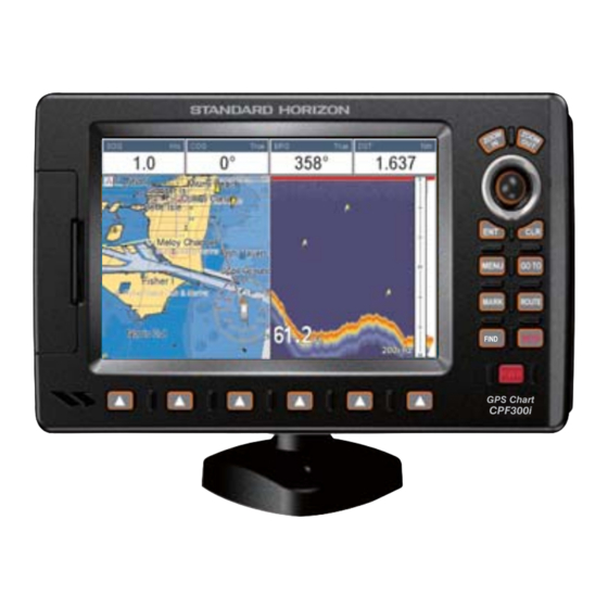
Page 29: Controls And Indicators
CONTROLS AND CONNECTIONS The CPF180i or CPF300i is controlled by using the keys located on the front panel. These labeled keys are dedicated to specific functions. As you press a key, a single audio beep confirms the key action; every time a key press is not valid, three rapid beeps sound to indicate that the key action is not valid. -
Page 30: The Cpf300I Soft Keys
LIST. Press any of the keys and you will see popup windows above the keys. To goto a specific page press the key with the desired popup window. The popup windows will automatically disappear if a key is not pressed or can be removed by pressing [CLR]. Page 32 CPF180i and CPF300i... -
Page 31: Getting Started
Look closely at the GPS Status page and you will see satellites and relative signal strengths of each satellite. After a fix is received the GPS Chart Plotter will automatically switch to the Chart Page with the ship icon centered on the screen. CPF180i and CPF300i Page 33... -
Page 32: Cursor Vs. Home Mode
To change from Cursor Mode to Home Mode press [CLR]. 3.1.2 Cursor and Menu selection speed The CPF180i and CPF300i allow you to control the speed the Cursor moves when the ShuttlePoint knob is pressed. To change the speed: Page 34... -
Page 33: Changing The Ship Icons
4. Move the ShuttlePoint knob to select the desired icon and press [ENT] or move the ShuttlePoint knob to the right to select a new icon. 5. Press [CLR] or move the ShuttlePoint knob to the left to exit the menu and show the Chart Page. CPF180i and CPF300i Page 35... -
Page 34: Changing The Backlight And Contrast
3.1.4 Changing the backlight and contrast With the CPF180i and CPF300i turned on, briefly press [PWR] to show the backlight and contrast popup window. Move the ShuttlePoint knob to the left or right to adjust the LCD backlight intensity or up or down to change the LCD contrast. Press [ENT] to set. - Page 35 7. Daylight Saving menu has 3 options: 7.1 OFF Select Off when your location does not recognize Daylight Savings Time; 7.2 ON Select On to manually turn Daylight Savings Time On. This is the default CPF180i and CPF300i Page 37...
-
Page 36: Selecting Loran Td Or Other Coordinate System
Example: Y/Z change to Z/Y. CHANGING THE CHART COLOR The CPF180i and CPF300i have preprogrammed settings allowing you to customize the look of the Chart page.The default is Sunlight, however there are other settings: Classic, NOAA, Night and Normal. Night is very useful during evening hours so not to impair night vision. -
Page 37: Selecting Language
Point knob to the desired language and press [ENT] or move the ShuttlePoint knob to the right. 5. Press [CLR] or move the ShuttlePoint knob to the left to exit the menu and show the Chart page. CHAR Figure 3.5 - Language Selection menu CPF180i and CPF300i Page 39... -
Page 38: Selecting Pages Using Soft Keys On Cpf300I
50kHz FULL PAGE, 200kHz FULL PAGE, 50kHz/CHART PAGE or 200kHz/CHART PAGE. Also when a SI-TEX RADAR antenna is connected (USA O ), any Soft Key can be customized to show Radar pages, RADAR FULL, RADAR/CHART, RADAR OVERLAY and RADAR/FISH FINDER. Page 40 CPF180i and CPF300i... -
Page 39: Settings In General Setup Menu
Select from a variety of ship icons that represent your vessels position on the Chart Page. The default is Icon 6. COMPASS ROSE Allows selection of compass direction indication around ship icon. The default is On. CPF180i and CPF300i Page 41... - Page 40 COG TIME LINE It is a line projected from the ship icon which indicates the distance your vessel will travel at the current speed. Selections are 2, 10 (default), 30 minutes, 1, 2 hours and infinite. Page 42 CPF180i and CPF300i...
-
Page 41: About Page
ShuttlePoint knob to the right. 3. The Information page appears on the screen (see the previous Figure). 4. Press [CLR] or move the ShuttlePoint knob to the left to exit and show the Chart page. CPF180i and CPF300i Page 43... - Page 42 Page 44 CPF180i and CPF300i...
-
Page 43: Find Services
FIND SERVICES USING FIND SERVICES & MORE FUNCTIONS The CPF180i and CPF300i have a dedicated [FIND] key that allows searching the optional C-MAP B /MAX C-CARD for Port Services, Ports, Tide Stations, Wrecks, EPPESEN Obstructions, Points Of Interest, Lakes, User Points, GPS Coordinates or Information on any point on the Chart. -
Page 44: Port
1. Press [FIND]. 2. Move the ShuttlePoint knob to highlight TIDE STATIONS and press [ENT] or move the ShuttlePoint knob to the right. 3. A popup window will be shown with a list of nearest Tide Stations. Page 46 CPF180i and CPF300i... -
Page 45: Wrecks
See the following table: ICON DESCRIPTION non-dangerous wreck dangerous wreck distributed remains of wreck F o u l wreck showing mast/masts Masts wreck showing any portion of hull or superstructure Figure 4.0.3 - Wreck icons Table CPF180i and CPF300i Page 47... -
Page 46: Obstructions
5. Another window will be shown detailing the Obstruction information. 6. Press [CLR] to show the actual position of the Obstruction on the Chart page. 7. Press [CLR] again at any time to return your cursor to your vessel’s position. Page 48 CPF180i and CPF300i... -
Page 47: Lakes Information
4.0.5.0 Quick Info On Lakes Upon viewing the chart of a lake, you can click on the Lake Info icon to query the available information immediately displayed with many details. For example, see the following picture: CPF180i and CPF300i Page 49... - Page 48 The following is an example of Full Info on Lakes: Figure 4.0.5.1 - Example of Full Info page To see the "Fishing" object press [MENU] (when the "Fishing" object is highlighted). On the screen appears: Page 50 CPF180i and CPF300i...
-
Page 49: Lakes By Name
6. Move the ShuttlePoint knob to highlight the desired Type and press [ENT]. 7. A popup window will be shown with a list of nearest Points Of Interest that fall into the Category and Type you have selected. CPF180i and CPF300i Page 51... -
Page 50: User Points
6. Press [CLR] at any time to return your cursor to your vessels position. WAAS 3D INFORM Figure 4.0.8 - Find User Points (Marks and Waypoints) 4.0.9 Coordinates This feature allows you to enter Coordinates (Latitude/Longitude) and view the entered position on the Chart Page. Page 52 CPF180i and CPF300i... -
Page 51: Information
ShuttlePoint knob through the Info Tree, all the relevant information of the selected object is shown on the lower part of the page. 4. Press [CLR] again at any time to return your cursor to your vessel’s position. Figure 4.0.10 - Find Information CPF180i and CPF300i Page 53... - Page 52 Page 54 CPF180i and CPF300i...
-
Page 53: Max Cartography Overview
Figure 5.0a - Inserting C-CARD (details) NOTE The small connector below the C-CARD is only used by Standard Horizon repair technicians. Key points are: Data Features · ISO Certification (electronic chart production process with quality certification) ·... - Page 54 MAX data cover different areas, the GPS Chart Plotter receives data from both charts (depending on the current position). · When NT data and MAX data cover the same area, the GPS Chart Plotter receives data only from MAX chart. Page 56 CPF180i and CPF300i...
-
Page 55: Map Functions
[ZOOM IN]/[ZOOM OUT] push (press and hold) causes an expansion or compression of the chart image, without a chart level change. CHART: US,NOS,GRAPH,11428D SCALE: 1:40000 CHART: US,NOS,GRAPH,11428D SCALE: 1:40000 CHART: US,NOS,GRAPH,11474 SCALE: 1:80000 Figure 6.0.0 - Zoom Type on CPF300i CPF180i and CPF300i Page 57... -
Page 56: Icon Size
6.0.2 Place Name Size On MAX charts it is possible to set the size of all names drawn on the charts, selecting between Standard (default), Medium and Large size. Page 58 CPF180i and CPF300i... -
Page 57: Perspective View
5. Move the ShuttlePoint knob to select the selection and press [ENT]. 6. Press [CLR] until the menu disappears or an easier method is to move the ShuttlePoint knob to the left until the chart page is shown. CPF180i and CPF300i Page 59... -
Page 58: Dynamic Nav-Aids
5. Move the ShuttlePoint knob to select the selection and press [ENT]. 6. Press [CLR] until the menu disappears or an easier method is to press the ShuttlePoint knob to the left a few times. Page 60 CPF180i and CPF300i... -
Page 59: Satellite Imagery
5. Move the ShuttlePoint knob to select the selection and press [ENT]. 6. Press [CLR] until the menu disappears or an easier method is to move the ShuttlePoint knob to the left until the chart page is shown. CPF180i and CPF300i Page 61... -
Page 60: Currents Prediction
1. Press [MENU], move the ShuttlePoint knob to highlight SETUP MENU and press [ENT]. 2. Move the ShuttlePoint knob to highlight MAX FUNCTIONS and press [ENT] or move the ShuttlePoint knob to the right. 3. Move the ShuttlePoint knob to highlight CURRENTS PREDICTION and press [ENT] or Page 62 CPF180i and CPF300i... -
Page 61: Chart Language
[I ]/[D ] to decrease/increase time; press [E ] to exit. On the CPF180i press [ENT] to set the date and time manually, and [GOTO]/[MENU] to decrease/increase time; press [CLR] to exit. 6.0.8 Chart Language The CPF180i and CPF300i may be customized to show the local language of the chart. -
Page 62: How To Show The Pictures Or Diagrams Of A Object
WAAS 3D Figure 6.0.9b - Example of Quick Info on camera icon on CPF300i On the CPF300i press [I ], or on the CPF180i press [ENT] for 1 second, to display the MAGE image on the screen: Figure 6.0.9c - Example of displayed image on CPF300i... -
Page 63: Enhanced Port Info
Additional attributes of Port Areas and Port Marinas have been included as Location, Country, Region, State, Harbour master telephone number etc., see the following figure. WAAS 3D PORT icon Figure 6.0.10 - Example of enhanced Port Info on CPF300i CPF180i and CPF300i Page 65... - Page 64 Page 66 CPF180i and CPF300i...
-
Page 65: Creating Marks
2. You will notice a Mark is placed under the location of the Cursor and a popup window is shown with the exact Lat/Lon of the Mark. 3. If the position is incorrect on the CPF180i press [ENT], select EDIT using the ShuttlePoint knob and press [ENT]. On the CPF300i, press [E ] that will allow you to change the position, Mark name and icon type. -
Page 66: Deleting A Mark Or Waypoint
1. After a Mark is created on the CPF180i press [ENT], move the ShuttlePoint knob to highlight EDIT and press [ENT]. On the CPF300i press [E ] to show the edit popup window. Figure 7.1 - Mark editing 2. The Mark Icon is selected, press [ENT]. A popup window appears: Figure 7.1a - Mark Icons... -
Page 67: Marks/Waypoints List
Sends the stored points to a external device (PC) capable of listening to NMEA WPL and RTE sentences. RECEIVE** When selected, receives points from an external device (PC) that is capable of sending NMEA WPL sentence. CPF180i and CPF300i Page 69... -
Page 68: Creating A New Mark With The User Points List
Mark or HIDE to hide on the Chart page the created Mark. Press [ENT]. 17. Press [CLR] to save the created Mark. 18. Press [CLR] again and the new Mark appears on the Chart page. Page 70 CPF180i and CPF300i... -
Page 69: Goto Cursor, Route And Mark
After entering in all the Marks it is a good practice to backup the points to a User C-CARD. Refer to Section 11. GOTO CURSOR, ROUTE AND MARK The CPF180i and CPF300i can easily be set to start navigating to the Cursor on the chart page, a saved Mark or a Route that was created. GOTO CURSOR 1. - Page 70 5. You will notice a circle is drawn around the Icon Symbol. This means the GPS Chart Plotter is now navigating to the point. 6. Press [CLR] to switch to the Chart page or Highway page to start navigating to the point. Page 72 CPF180i and CPF300i...
-
Page 71: Man Over Board (Mob) Function
During navigation, the “MOB” feature provides a one-touch method of storing a location, such as a point were a crew member fell overboard. In this mode, the CPF180i or CPF300i places a MOB point on the Chart page and all the navigation data shown is related to navigating back to this point, allowing you to retrace your path to the MOB point efficiently. - Page 72 Page 74 CPF180i and CPF300i...
-
Page 73: Routes
ROUTES The CPF180i and the CPF300i have the capability to store 50 Routes with 100 Waypoints or Marks in each Route. A Route can consist of Waypoints or Marks. The difference is when a Route is made using Waypoints and the Route is deleted the Waypoints are also deleted. -
Page 74: Changing The Name Of A Route
4. Press [ROUTE]. Another Waypoint is shown under the cursor and a line joins the starting Waypoint to the second Waypoint. 5. Repeat steps 3 and 4 until all Waypoints are entered into the Route. Page 76 CPF180i and CPF300i... -
Page 75: Making Additional Routes
Figure 9.2 - Olympic Route creation (1) 6. Then move the ShuttlePoint knob to the last Waypoint. On the CPF180i press [ENT]. 7. On the CPF180i move the ShuttlePoint knob to highlight OLYMPIC and press [ENT]. On the CPF300i press [O ]. -
Page 76: Inserting A Waypoint Into A Route
11. Press [CLR] to show the Chart page is shown. INSERTING A WAYPOINT INTO A ROUTE On the CPF180i place the cursor on the navigation line between two Waypoints and press [ROUTE]. On the CPF300i placing the cursor on the navigation leg between two points, soft key labels appear: press [I ]. -
Page 77: Goto A Route
6. On the Chart page a circle with a flag is shown on the first leg of the Route and a navigation line is shown, indicating the GPS Chart Plotter is navigating to the first Waypoint in the Route. Figure 9.6.0a - GOTO ROUTE procedure (2) CPF180i and CPF300i Page 79... -
Page 78: Using The Shuttlepoint Knob
The Route Check function is used after you have created a Route to ensure you and your vessel will not have problems while navigating. This is done by the CPF180i and CPF300i by reviewing the Route and looking for the following hazards that may effect safe navigation. - Page 79 Selects among Minimum, Low, Medium, High and Maximum. See the picture below. The default setting is Medium. ROUTE CHECK REPORT Shows the list of the dangerous objects found on the charts crossed by the Route. CPF180i and CPF300i Page 81...
- Page 80 (like DSC, MOB, Mark). In the case of checking a single point towards which the navigation is started, the leg for which the Route Check is executed is defined by the current position (the leg’s starting point) and the destination point (the leg’s ending point). Page 82 CPF180i and CPF300i...
-
Page 81: Tracks
The Track function can be setup to lay down a Track for a predetermined time or distance interval. If you have a fast moving boat you may want to setup the CPF180i or CPF300i to record a Track point every 0.5NM or if you have a sail boat you may want to setup to lay down a Track point once every 1 minute. -
Page 82: Saving And Starting A New Track
Shows or hides a Track shown in ACTIVE TRACK menu LINE COLOR Selects the color of the Track line DELETE Deletes a Track selected in the ACTIVE TRACK menu STEP UNIT Allowable selection are Distance or Time Page 84 CPF180i and CPF300i... -
Page 83: Trip Log
5. A warning popup window will be shown to confirm if you want to reset the Trip Log. Move the ShuttlePoint knob to highlight YES and press [ENT].The Trip Log is now reset. 6. Press [CLR] to store and exit the editing mode Figure 10.1. 1 - Trip Log Reset CPF180i and CPF300i Page 85... - Page 84 Page 86 CPF180i and CPF300i...
-
Page 85: User C-Card
11.0.1 Transferring files to the optional User C-CARD 1. Remove a C-CARD if present and insert the optional C-MAP B /MAX EPPESEN User C-CARD into the slot. the ShuttlePoint knob to highlight USER POINTS and press [ENT] Press [MENU], move CPF180i and CPF300i Page 87... -
Page 86: Loading A File From The Optional User C-Card
3. Open the door, remove the User C-CARD from the slot and insert another User C-CARD into the same slot. 4. Move the ShuttlePoint knob to highlight REFRESH and press [ENT]. This "new" User C-CARD is now ready to receive and store information. Page 88 CPF180i and CPF300i... -
Page 87: Pages
12. PAGES The CPF180i and CPF300i have many pages that are designed to ease your navigation. CHART NAVIGATION HIGHWAY CELESTIAL WAAS WAAS GPS STATUS NMEA DISPLAY Display example with RADAR connected Chart and Fish Finder WAAS Figure 12 - Example of screen display pages... -
Page 88: Chart Page
Dual Chart page. It happens when the GPS Chart Plotter updates the displayed chart in the not active window. So the user understands that the GPS Chart Plotter is busy. Page 90 CPF180i and CPF300i... -
Page 89: For Cpf300I Focus Soft Key On Dual Chart Page
1. Press and hold [FIND] for 2 seconds. The "red" boarder around the window is moved from active window to the other. Repeat the step 1. to move the focus from a window to another. CPF180i and CPF300i Page 91... -
Page 90: Single Chart Page
Distance & Bearings from Fix to Cursor Figure 12.0.2 - Example of Single Chart Page 12.0.3 Window Selections The default is the Two Line Small window. The CPF180i and CPF300i windows may be changed by the procedure below. FULL CHART (None) -
Page 91: Customizing The Data Windows
3. Move the ShuttlePoint knob up/down or left/right to choose the desired setting and press [ENT]. 4. Press [CLR] to store and exit the editing mode. NOTE Data window field on the NAVIGATION, HIGHWAY, GPS STATUS, and NMEA pages may be customized in the above manner. CPF180i and CPF300i Page 93... -
Page 92: Additional Functions On Chart Page
5. Press [CLR] or move the ShuttlePoint knob to the left until the Chart page appears. AUTO INFO On Points AUTO INFO On All AUTO INFO Off Figure 12.0.6 - Example of Auto Info settings Page 94 CPF180i and CPF300i... -
Page 93: Display Mode
Icon + Depth Icon Icon Icon Icon Icon Obstructions Icon + Depth Icon Icon Icon Icon Icon Diffusers Icon + Depth Icon Icon Icon Icon Icon Wrecks Icon + Depth Icon Icon Icon Icon Icon CPF180i and CPF300i Page 95... -
Page 94: Marine Settings
: Sets the minimum depth limit to show Depth Sounding, Bathymetric Lines and Depth Area. Depth Range Max : Sets the max depth limit to show Depth Sounding, Bathymetric Lines and Depth Area. 0-1000 Ft 50-100 Ft Figure 12.0.9 - Depth Settings Page 96 CPF180i and CPF300i... -
Page 95: Land Settings
Each box indicates an area where more detail is available. The Chart Boundaries are only show when a C-MAP B or MAX CARD is inserted into the GPS EPPESEN Chart Plotter. See the pictures below: Chart Boundaries ON Chart Boundaries OFF CPF180i and CPF300i Page 97... -
Page 96: Underwater Objects Settings
Depth Value”); ICON (the object icon is visible without tags, in the range selected from “Underwater Object Depth Value” option); ICON+DEPTH (the object icon and tag is visible, in the range selected from “Underwater Object Depth Value” option). Page 98 CPF180i and CPF300i... -
Page 97: Customizing Chart Settings
The COG heading is computed and supplied to the plotter from the internal GPS or external GPS. Fix position Time WAAS 3 Speed Over Ground Course Over Ground Bearing to Destination Time To Go Distance to Destination Compass Rose Figure 12.2 - Navigation page with Compass Rose CPF180i and CPF300i Page 99... -
Page 98: Highway Page
1. Press [ENT] and a popup window will be shown. 2. Moving the ShuttlePoint knob up or down changes the digits and left and right selects the month, day and year. 3. Press [CLR] to exit and view the information. Page 100 CPF180i and CPF300i... -
Page 99: Gps Status Page
Vertical Dilution of Precision Horizontal Dilution of Precision Tracked, but not used, Satellite Used Satellite Used Satellite COG (Course Over Ground) Figure 12.5 - GPS Status page The WAAS/GPS Icon area may change due to the satellite reception: CPF180i and CPF300i Page 101... -
Page 100: Waas/Egnos Setting
Move the ShuttlePoint knob to highlight the preferred item and press [ENT]. Press [CLR] until the menu disappears or an easier method is to move the ShuttlePoint knob to the left until the menu disappears. Page 102 CPF180i and CPF300i... -
Page 101: Nmea Display Page
GSV, HDG, HDM, HDT, RMC, VHW, VTG, DPT, DBT, MTW, VWR, VWT, TLL, WPL, RTE. CHANGING the NMEA PAGE Windows 1. On the CPF180i, press [MENU]. Move the ShuttlePoint knob to highlight NMEA DISPLAY and press [ENT]. Figure 12.6a - NMEA Display menu on CPF300i 2. -
Page 102: Nmea Trend
Trends will be shown for Depth, Temp and Speed (DST521 or DST526 must be connected to show speed through the water) when a Standard Horizon transducer is connected. To show Wind trend information the CPF180i or CPF300i must be connected to the NMEA output of a external Wind instrument. -
Page 103: Vhf Digital Selective Calling
18.0 17.5 17.00 12:15 Figure 12.8a - NMEA Trend pages on CPF180i/CPF300i 12.9 VHF DIGITAL SELECTIVE CALLING Digital Selective Calling is a semi-automated method of establishing a VHF radio call. DSC had also been designated as part of the Global Maritime Distress and Safety System (GMDSS). -
Page 104: Interfacing
Figure12.9.0a - Interfacing to VHF Radio for CPF300i 12.9.1 Distress Call STANDARD HORIZON GPS chart plotters are able to display the location of a vessel in distress when interfaced to a compatible DSC VHF with NMEA 0183 output and the radio receives a DSC Distress Call. -
Page 105: Position Request
Figure 12.9.1 - DSC Log - Distress Call 12.9.2 Position Request STANDARD HORIZON GPS chart plotters are able to display the location of a vessel when connected DSC VHF radio and when a Position Request or Report call is received. - Page 106 Page 108 CPF180i and CPF300i...
-
Page 107: Advanced Settings
13.0 INPUT/OUTPUT (NMEA, AIS, RADAR) 13.0.0 Input The CPF180i has 1 NMEA Input and 2 NMEA Outputs and the CPF300i has 3 Inputs and 3 Output connections. These ports may be set up to receive and output the following. · NMEA-0183 - NMEA devices* set to 4800 Baud (default setting) ·... -
Page 108: Navigate
Chart Orientation Resolution : Sets the angle the vessel has to change before the chart is redrawn. The default setting is 30 degrees. Example: if the vessel is heading 000T at a speed of 25 Knots, the display Page 110 CPF180i and CPF300i... -
Page 109: Loran Td
Arrival, XTE, Depth, Anchor and Grounding Alarm. Arrival Alarm : Alerts when the vessel is approaching a single destination point or when arriving at a leg in a Route. Available selections: 0.00 to 9.99NM. CPF180i and CPF300i Page 111... -
Page 110: Simulation
Course and Speed selection discussed later in this table. c. Route - this selection allows you to navigate to a saved route. Course : To start the simulator you can insert the Course value. Page 112 CPF180i and CPF300i... -
Page 111: Navigating A Route In Simulation Mode
Manual. If Auto Info is set to On, when receiving the Position Request it is possible to center the cursor over the top of the Position Request icon and show the Position Request popup window CPF180i and CPF300i Page 113... - Page 112 Page 114 CPF180i and CPF300i...
-
Page 113: Ais
· Receive details from other vessels or navigation aids within VHF range. STANDARD HORIZON GPS Chart Plotters are able to display AIS target (for collision avoidance) on the Chart Page and AIS list pages when connected to a AIS receiver (GX2100 or GX2150 STANDARD HORIZON VHF/AIS transceiver) or transponders which output NMEA 0183 VDM sentence at 38400 or 4800 baud. -
Page 114: Menu
By placing the cursor over a AIS Target icon using the ShuttlePoint knob, the following information is displayed (see the following picture): · Vessel Name · MMSI number · Radio Call Sign · SOG · COG · CPA and TCPA values Page 116 CPF180i and CPF300i... -
Page 115: List
GPS Chart Plotter. 14.5 AIS TARGET COLORS The received AIS Targets are shown in color. The color depicts the type of AIS ship shown on the Chart Page. Refer to following table. CPF180i and CPF300i Page 117... - Page 116 Vessels with antipollution facilities or equipment (light blu) Low enforcement vessels (light red) Medical transport (dark green) Vessels according to Resolution N 18 (Mob-83) (cyan) (red) Passenger ship (magenta) Cargo ship (dark gray) Figure 14.5 - Color AIS Targets Page 118 CPF180i and CPF300i...
-
Page 117: C-Weather Service
15. C-WEATHER SERVICE C-Weather is a free service available on the CPF180i and CPF300i. C-Weather service gives excellent coverage for the whole World. Weather forecasts are based on data received from the leading meteorological centers. This data is processed by Jeppesen server and made available via INTERNET connection to be transferred by using the C-Map PC-Planner Windows Application. -
Page 118: Copy From User C-Card
(see the previous "Weather data package" table) are downloaded. [S ] (or [CLR] for CPF180i) allows to interrupt the data download. At the end of the operation press ] (or [CLR] for CPF180i) to close the window. 15.0.1 Copy From User C-CARD Allows the whole data package C-Weather loading from the User C-CARD. -
Page 119: Mobilarm
16.0 MOBILARM-GPS CHART PLOTTER CONNECTION Connect the MOBILARM system to one of the Ports on the Standard Horizon GPS Chart Plotter. Refer to Par. 2.4.0 “Connection Table” for CPF180i, Par. 2.4.2 “Connection Table” for CPF300i and MOBILARM Owner’s Manuals for connections. -
Page 120: Software Setup
NOTE Note the CPF180i only has one NMEA Input so Port1 will have to be set to MOBILARM. The CPF300i has 3 Ports so Port 1, 2 or 3 can be be used. Port 1 Example Chart Plotter MOBILARM Blue... -
Page 121: Mobilarm Ptx
On the GPS Chart Plotter all menus and/or pages are closed and the chart is centered on the PTX MOB received position. A Audible Alarm is heard and a pop-up warning window appears to notify that a PTX has been received: CPF180i and CPF300i Page 123... -
Page 122: Placing Cursor On The Ptx Icon
Figure 16.3.0a - Example of PTX warning window on CPF300i Figure 16.3.0b - Example of PTX warning window on CPF180i It is possible to Goto (navigate) to the received MOBILARM PTX position (see Par. 16.4.1) or open the MOBILARM Alarm Status List page (see Par. 16.4.2). Selecting Goto or Alarm Status List will mute the Audible Alarm. -
Page 123: Delete Ptx
Figure 16.4a - Example of PTX information window on CPF180i 16.4.0 Delete PTX The Delete PTX function permamently removes the selected PTX from the MOBILARM Alarm Status List and from the Chart page. Using the ShuttlePoint knob, move the cursor over the PTX icon and then: CPF180i press [ENT], select DELETE using the ShuttlePoint knob and press [ENT]. -
Page 124: The Mobilarm Alarm Status List
If the navigation is set to the selected PTX icon, to terminate the navigation: CPF180i press [ENT], select STOP GOTO using the ShuttlePoint knob and press [ENT]. Figure 16.4.1b - Example of Stop Goto PTX on CPF180i CPF300i press [S Figure 16.4.1c - Example of Stop Goto PTX on CPF300i... - Page 125 (if open) and center the chart selected PTX. DELETE Deletes the selected PTX. SHOW Centers the chart on the selected PTX. SHOW ALL Selects the best chart scale to see al PTX icons on the chart at the same time. CPF180i and CPF300i Page 127...
- Page 126 Page 128 CPF180i and CPF300i...
-
Page 127: Fish Finder
4. Move the ShuttlePoint knob to highlight FISH FINDER and press [ENT] or move the ShuttlePoint knob to the right. 5. Move the ShuttlePoint knob up/down to select OFF and press [ENT] or move the CPF180i and CPF300i Page 129... -
Page 128: Understanding The Fish Finder Page
17.1 UNDERSTANDING THE FISH FINDER PAGE The display on CPF180i and CPF300i shows a time history of the echoes received by the transducer. The CPF180i and CPF300i have a menu that allows adjustments to receiver sensitivity, depth range and scrolling speed of the Fish Finder display. -
Page 129: Understanding The Fish Finder Display
Thermo- clines are represented as horizontal stripes of noise. They are very important for fishing since often many species of game fish like to suspend in, just above, or just below the CPF180i and CPF300i Page 131... -
Page 130: Displaying The Fish Finder Page
From Fish Finder page, press [MENU] two times. Figure 17.2 - Main Menu on CPF300i 2. Move the ShuttlePoint knob to highlight FISH FINDER on CPF300i or RADAR/FISH on CPF180i; press [ENT]. Figure 17.2a - Fish Finder page selection menu on CPF300i Page 132... -
Page 131: Auto Full Page
To select the area to be zoomed in move the ShuttlePoint knob Up or Down which moves the VRM line. To zoom In or Out, press [ZOOM IN] or [ZOOM OUT]. The zoom ranges are 2x and 4x the normal Fish Finder display. 30.0Ft Figure 17.2.2 - Zoom Full page CPF180i and CPF300i Page 133... -
Page 132: 200 Khz And 50 Khz Fish/Chart
Figure 17.2.3 - Fish/Chart page On the CPF180i when the Fish/Chart Page has been selected use [FIND] to place the focus on the Chart page or on the Fish Finder window. On the CPF300i please see the following paragraph. -
Page 133: Radar Combo Page
Figure 17.2.4.2 - Example of Combo page with [F ] shown OCUS 3. Move the ShuttlePoint knob to highlight the desired window and press [ENT]. The red boarder is moved to the focused window. CPF180i and CPF300i Page 135... -
Page 134: Soft Key Operation (Only For Cpf300I)
This section explains how to show the Fish Finder Setup menu and describe the Fish Finder Setup menu sub-options. 1. From the Full Fish Finder page, press [MENU]. The following menu appears: Figure 17.4 - Fish Finder Setup menu Page 136 CPF180i and CPF300i... -
Page 135: Presets
For Range and Shift settings refer to Range menu (see Par. 17.8). 17.6 FREQUENCY Allows you to choose the frequency among Auto, 50 kHz, 200 kHz or 50&200 kHz when single frequency page is selected. Figure 17.6 - Frequency menu CPF180i and CPF300i Page 137... -
Page 136: Gain Mode
Used to set the depth Range (from the surface) the Fish Finder display will show. 17.8.0.1 Auto Range The Fish Finder determines automatically the Range as to keep the bottom visible in the lower bottom of the screen. In this mode, Shift is always set to 0. Page 138 CPF180i and CPF300i... -
Page 137: 2Bottom Lock
Figure 17.8.2 - Example of Depth and Shift 17.9 INTERFERENCE REJECTION Figure 17.9 - Interference Rejection menu Turns On or Off a filter to remove noise from other Fish Finder or Depth Sounders that may be near by when fishing. CPF180i and CPF300i Page 139... -
Page 138: Sensitivity Menu
One indication that the STC needs to be changed is when the display intermittently changes the depth from the correct depth to a very shallow depth. Figure 17.10.1 - STC - Surface Clutter Page 140 CPF180i and CPF300i... -
Page 139: Surface Noise Filter
..., 8. When it is set to OFF the Surface Noise is not cancelled. When it is set to 1 the Surface Noise is attenuated from surface down to a depth of 5 Ft, increasing the Surface Noise CPF180i and CPF300i Page 141... -
Page 140: Display Setup
Allows you to change the color of the Fish Finder display from Blue (default), White, Black, Gray scale. Figure 17.11.0 - White and Blue background examples 17.11.1 Scrolling Speed Controls the rate the Fish Finder scrolls and updates the Fish Finder display. Page 142 CPF180i and CPF300i... -
Page 141: White Line
17.12.1 Calibrate Water Speed Used to calibrate the Water Speed readings from the transducer. Adjustment can be made from -10% to +10%. CPF180i and CPF300i Page 143... -
Page 142: Calibrate Water Temp
The Fish Alarm can be set to detect and alert you depending on the size of fish. The options are: Off, Small, Medium, Big and Huge. The alarm sounds if the set size (or bigger) is detected. 17.13.3 Temperature Upper Triggers an alarm when the transducer reports a temperature above the set temperature. Page 144 CPF180i and CPF300i... -
Page 143: Temperature Lower
Card that may be used to backup the User Points and Tracks too). Figure 17.15 - C-CARD - Load settings 17.16 RESTORE CURRENT PRESET DEFAULTS This option restores the default values only for the current presets and does not affect the other presets. CPF180i and CPF300i Page 145... - Page 144 Figure 17.16 - C-Card - Restore settings Page 146 CPF180i and CPF300i...
-
Page 145: Troubleshooting
Internal RAM memory to become corrupted. To solve this issue, perform a RAM clear (refer to Section 19). NOTE After performing a RAM Clear all Marks, Routes and tracks will be erased. To back up these points refer to Section 11 for details. CPF180i and CPF300i Page 147... - Page 146 Page 148 CPF180i and CPF300i...
-
Page 147: Technical Tests
Each time you move the ShuttlePoint knob to right, the screen will decrease brightness, move it to the left to increase brightness. Backlight The second option allows to set the backlight. Operates in similar mode as Contrast. CPF180i and CPF300i Page 149... -
Page 148: Cartridges
ASCII mode (normal or small) and [CLR] to exit. Loop-Back Test This is a special test done during the production phase to check the serial ports integrity. This function is only required by Standard Horizon. Page 150 CPF180i and CPF300i... -
Page 149: Specifications
HDT, RMC, VHW, VTG, DPT, DBT, MTW, VWR, VWT, TLL, WPL, RTE REMOVABLE Grip 4.05" [103mm] MENU GOTO MARK ROUTE FIND REMOVABLE Mounting Bracket 3.9" [98.6mm] 1.5" 1.5" [37mm] [37mm] 7.1" [181mm] 0.2" [4.1mm] Figure 20.0 - CPF180i Dimensions [inch/mm] CPF180i and CPF300i Page 151... -
Page 150: Cpf300I Specifications
HDT, RMC, VHW, VTG, DPT, DBT, MTW, VWR, VWT, TLL, WPL, RTE REMOVABLE Grip 6" [152.4mm] MENU GOTO MARK ROUTE FIND REMOVABLE Mounting Bracket 3.9" [98.6mm] 1.5" 1.5" [37mm] [37mm] 9.9" [251mm] 0.2" [4.1mm] Figure 20.1 - CPF300i Dimensions [inch/mm] Page 152 CPF180i and CPF300i... -
Page 151: Ff Module Specifications
Reacquisition < 1 second Hot Start 1 second outdoor, 10 seconds indoor Warm Start 29 seconds Cold Start 29 seconds Accuracy < 2.5m with SBAS < 2.0m NMEA Output Messages GGA, RMC, GSA, GSV, TXT CPF180i and CPF300i Page 153... - Page 152 Page 154 CPF180i and CPF300i...
-
Page 153: Appendix: Terms
GPS3D – The GPS is receiving at least 4 Satellites. HDG (Heading) – Shows heading from a External Flux Gate Compass when connected. HDOP/VDOP – Horizontal/Vertical Dilution of Precision. It is a parameter indicating the CPF180i and CPF300i Page 155... - Page 154 70 metres (230FT) in Height and up to 600 metres (2.000 FT) in diameter. Position Request – Marine DSC VHF Function of transmitting a GPS position to another Marine DSC VHF. When GPS Chart Plotter is connected to STANDARD HORIZON GPS the position of another vessel is shown on the Chart page.
- Page 155 WATER TEMP – Shows the sea water temperature for when a Digital Speed Log/Temp instrument with NMEA is connected. XTE (Cross Track Error) – The distance your vessel is off course (left or right) to a Destination point. CPF180i and CPF300i Page 157...
- Page 156 Page 158 CPF180i and CPF300i...
-
Page 157: Analytical Index
Apparent Wind Direction ..93, 155 Calibration ........111 Apparent Wind Speed ....93, 155 camera icon ........64 Arrival Alarm ........111 Cartographic Data ......56 ASF ........... 38 Cartography ....55, 151, 152 CPF180i and CPF300i Page 159... - Page 158 CPA Alarm ......115, 116 CAUTION ..........5 CPA Limit ....... 115, 116 Caution page ........33 CPF180i 13, 14, 17, 18, 19, 106, 151 Caution pages ........33 CPF180i Connection Table ....21 CELESTIAL ........40 CPF180i Connections ....... 22 Celestial page ......
- Page 159 Find Points Of Interest ...... 52 DSC Distress Call ......106 Find Port Services ......46 DSC LOG .......... 40 Find User Points ....... 52 DSC Log ......... 107 Find Wrecks ........48 DSC POLLING ........ 113 Finnish ..........39 CPF180i and CPF300i Page 161...
- Page 160 INPUT/OUTPUT ......109 GOTO A ROUTE ......79 Inserting C-CARD ......55 GOTO CURSOR ....... 71 Inserting Waypoint ......78 Goto PTX ........125 INSTALLATION ........ 17 GOTO ROUTE ........72 Installing the antenna ......20 Page 162 CPF180i and CPF300i...
- Page 161 Nav-Aids ........56, 60 Longitude .......... 97 Navigate Menu ........ 110 Loran TD ........38, 111 Navigating a Route ......113 Lost Target ........115 NAVIGATION ........40 LOW WATER ......... 156 NAVIGATION PAGE ......42 CPF180i and CPF300i Page 163...
- Page 162 PTX warning window ...... 124 Pair ............ 38 PWR ..........32 PAL ........... 27 Palette ..........61 PC ............. 69 Quick Info ......... 56, 116 PC COM settings ......26 Quick Info on AIS ......117 Page 164 CPF180i and CPF300i...
- Page 163 SPECIFICATIONS ..151, 152, 153 Satellite ..... 13, 61, 102, 156 Speed ..41, 83, 93, 113, 153, 156 Satellite Imagery ....... 61 Speed Filter ......13, 102 SAVE (user C-CARD) ....... 88 Speed Log ........ 25, 103 CPF180i and CPF300i Page 165...
- Page 164 User Points ....32, 52, 151, 152 Tide Stations ....32, 46, 47, 56 Using Trip Log ........85 Tides & Currents ......95, 96 UTC ........... 36 Tides Preview ........56 UTM ......... 38, 110 Page 166 CPF180i and CPF300i...
- Page 165 Zoom Full Page ....... 133 WAAS/EGNOS ....... 102 ZOOM IN ........... 31 WARNING .......... 4 ZOOM OUT ........31 Warning ..........72 Zoom Pages ........133 Warning Message ......130 Zoom Type ........57 Water Resistance ....151, 152 CPF180i and CPF300i Page 167...
- Page 166 Products shall be limited solely to repair or replacement, at its option, of the Product or part(s) therein which, upon examination by STANDARD HORIZON, appear to be defective or not up to factory specifications. STANDARD HORIZON may, at its option, repair or replace parts or subassemblies with or reconditioned parts and subassemblies.
Need help?
Do you have a question about the CPF180i and is the answer not in the manual?
Questions and answers