Sign In
Upload
Manuals
Brands
Garmin Manuals
GPS
G300 for Cessna SkyCatcher
Garmin G300 for Cessna SkyCatcher Manuals
Manuals and User Guides for Garmin G300 for Cessna SkyCatcher. We have
5
Garmin G300 for Cessna SkyCatcher manuals available for free PDF download: Pilot's Manual, Installation Manual, User Manual
Garmin G300 for Cessna SkyCatcher Pilot's Manual (296 pages)
G300 Pilot's Guide
Brand:
Garmin
| Category:
GPS
| Size: 11 MB
Table of Contents
Table of Contents
13
Section 1 System Overview
19
Line Replaceable Units
19
G300 Standard Panel
22
G300 Upgraded Panel
23
Display Overview
24
Secure Digital (SD) Cards
25
G300 Controls
26
System Power-Up
28
System Operation
30
Display Operation
30
G300 System Annunciations
32
AHRS Operation
32
Gps Data
33
Accessing System Functionality
34
Menus
34
Data Entry
35
Main Pages
38
Main Page Softkeys
42
Waypoint Page Softkeys
47
Flight Planning Softkeys
49
Nearest Page Softkeys
50
Accessing the Information (INFO) Page
51
Viewing GPS Receiver Status
51
New Location
53
Entering a New Location
53
Acquiring Satellites
53
Position
54
Data Fields and Layout (Dual Display - MFD)
56
System Settings
57
Data Bar Fields
58
Display
59
Color Mode
60
Adjusting the Color Mode
60
Sound
61
Units
63
Date & Time
64
Position
65
Alarms
65
Setting Airport Criteria
67
Section 2 Flight Instruments
69
Flight Instruments
69
Airspeed Indicator
71
Attitude Indicator
72
Altimeter
73
Setting the Selected Altitude
74
Selecting the Altimeter Barometric Pressure Setting
74
Altitude Alerting
77
Vertical Speed Indicator (VSI)
78
VNAV Indicator
78
Horizontal Situation Indicator (HSI)
79
Bearing Pointers and Information Windows
82
Heading Strip and Turn Rate Indicator
84
OBS Mode
84
Table of Contents
86
Supplemental Flight Data
86
Outside Air Temperature
86
Wind Data
86
Vertical Navigation (VNAV)
87
Using the VNAV Feature
88
Section 3 Engine Indication System
91
EIS Display & ENG Page
91
Section 4 COM Interface
95
Auto-Tuning Frequencies
95
Section 5 GPS Navigation
99
Introduction
99
Compass Arc
99
Using Map Displays
100
Map Page Setup
101
Map Page
101
Gps Navigation
102
Map Range
105
Map Panning
106
Panning the Map
107
Measuring Bearing and Distance
108
Topography
109
Satellite View
110
Map Symbols
110
Airways
111
Displaying/Removing Airways
112
Reviewing Information for an Airway
112
Waypoints
114
Automatic Waypoint Selection
115
Selecting a Runway
117
Nearest Information
119
Waypoint Page
119
Nearest Airport Criteria
120
Nearest Airports Page
120
Weather Information
121
Intersections
122
Nearest Airport Weather Page
122
Ndbs
123
Vors
124
User Waypoints
125
Deleting User Waypoints
128
Airspace
129
Airspace Alert Messages
130
Nearest Airspace Page
130
Smart Airspace
131
Direct-To Navigation
131
Section 6 Flight Planning
135
Introduction
135
Flight Plan Data Fields
136
Flight Plan Creation
137
Flight Planning
138
6.4 Flight Plan Activation
139
Flight Plan Storage
139
Flight Plan Activation
140
Flight Plan Editing
141
Adding Waypoints to an Existing Flight Plan
141
Editing Flight Plan Speed, Fuel, And/Or Name
143
Copying Flight Plans
145
Deleting Flight Plans
145
Deleting the Active Flight Plan
146
Inverting a Flight Plan
147
Importing/Exporting Flight Plans
148
Approaches
149
Selecting an Approach
150
Activating Vectors-To-Final
153
Trip Planning
154
Section 7 Hazard Avoidance
155
XM WX Satellite Weather
155
XM Datalink Weather Advisory
155
Hazard Avoidance
156
XM WX Satellite Weather Products
157
Winds Aloft
159
Storm Cells
161
Freezing Levels
165
Using XM WX Satellite Weather Products
168
Terrain
172
Synthetic Vision
173
Terrain Information
173
Terrain Views
174
Obstacle Information
175
Terrain Settings
176
Terrain Alerts
177
Section 8 Additional Features
181
Synthetic Vision (SVX)
182
Additional Features
183
Synthetic Vision Operation
184
Flight Path Marker
187
Airport Signs
189
Safetaxi
193
Safetaxi Cycle Number and Revision
194
Flitecharts
195
Aircraft Symbol
197
Chart Range
197
Flitecharts Cycle Number and Expiration Date
198
AOPA Data
199
S Irius XM Radio Entertainment (Optional)
200
Activating Siriusxm Satellite Radio Services
200
Using S Irius XM Radio
202
Selecting a Category
202
Selecting a Channel
203
Using Favorites
204
Adjusting the Volume
205
Electronic Checklists (Optional)
206
Flight Data Logging
207
Section 9 Integrated Autopilot (Optional)
209
Integrated Autopilot Operation
210
Controls
210
G300 Autopilot Status BOX
214
Integrated Autopilot Modes
215
Rev. E Garmin G300 Pilot's Guide
215
Table of Contents
216
Vertical Modes
216
Pitch Hold Mode (PIT)
216
Selected Altitude Capture Mode (ALTS)
218
Altitude Hold Mode (ALT)
219
Vertical Speed Mode (VS)
221
Vertical Navigation Mode (VNAV)
223
Lateral Modes
227
Roll Hold Mode (ROL)
227
Heading Mode (HDG)
229
Navigation Mode (GPS)
230
Changing the Selected Course (OBS Mode)
232
Integrated Autopilot Alerts
232
Section 10 Annunciations & Alerts
233
Miscellaneous Message Advisories
233
System Status Messages (INFO Page)
235
System Status Messages
236
Aural Alerts
239
Terrain
239
PFD Annunciations and Alerting Functions
240
CAS Messages
240
Terrain Annunciations
241
Integrated Autopilot Alerts (Optional)
242
Section 11 Appendices
245
Appendix A: Data Field Options
245
Appendix B: Utilities
249
Flight Log
249
Track Log
251
Displaying/Removing the Track Log on the Map Page
252
Changing Track Log Settings
252
Clearing the Track Log
253
Heading Line
255
Weight & Balance
256
EPE Circle
258
Proximity Waypoints
259
Deleting Proximity Waypoints
260
Appendix C: SD Card Use and Databases
261
Installing and Removing SD Cards
261
G300 Databases
262
Updating G300 Databases
265
Exporting Track Logs and User Waypoints
267
Importing/Exporting Flight Plans
268
Flight Data Logging
268
Appendix D: Map Datum and Location Formats
269
Map Datums
269
Location Formats
269
Appendix E: Abnormal Operation
271
Loss of GPS Position
271
G300 System Failure Annunciations
272
Reversionary Mode
273
Synthetic Vision Troubleshooting
273
Unusual Attitudes
274
Appendix F: Display Symbols
275
VFR Symbols
275
IFR Symbols
276
Airspace Symbols
278
Appendix G: Glossary
281
Appendix H: License Agreement and Warranty
287
Contact Garmin
287
Software License Agreement
287
Limited Warranty
287
AOPA Airport Directory Notice
288
Siriusxm Satellite Radio Service Agreement
289
Weather Data Warranty
289
Advertisement
Garmin G300 for Cessna SkyCatcher Pilot's Manual (284 pages)
Brand:
Garmin
| Category:
GPS
| Size: 27 MB
Table of Contents
Table of Contents
13
Section 1 System Overview
19
Line Replaceable Units
19
G300 Standard Panel (Single Display)
22
G300 Upgraded Panel (Dual Display)
23
Display Overview
24
Secure Digital (Sd) Cards
25
G300 Controls
26
System Power-Up
28
System Operation
29
Display Operation
29
G300 System Annunciations
31
AHRS Operation
31
Gps Data
32
Accessing System Functionality
33
Menus
33
Data Entry
35
Main Pages
38
Main Page Softkeys
42
Map Page Softkeys
45
Waypoint Page Softkeys
46
Flight Planning Softkeys
48
Nearest Page Softkeys
49
Accessing the Information (Info) Page
49
Viewing GPS Receiver Status
49
New Location
51
Entering a New Location
51
Acquiring Satellites
52
Satellite Information
52
Position
53
Data Fields and Layout (Dual Display - MFD)
54
System Settings
55
Data Bar Fields
56
Display
57
Sound
58
Units
59
Date & Time
60
Position
60
Alarms
61
Setting Airport Criteria
62
Section 2 Flight Instruments
65
Flight Instruments
65
Airspeed Indicator
67
Attitude Indicator
68
Vspeed Reference
68
Altimeter
69
Setting the Selected Altitude
70
Selecting the Altimeter Barometric Pressure Setting
70
Altitude Alerting
71
Vertical Speed Indicator (VSI)
72
Horizontal Situation Indicator (HSI)
72
Bearing Pointers and Information Windows
75
Heading Strip and Turn Rate Indicator
77
OBS Mode
77
Rev. D Garmin G300 Pilot's Guide I
77
Table of Contents
79
Supplemental Flight Data
79
Outside Air Temperature
79
Wind Data
79
Vertical Navigation (Vnav)
80
Using the VNAV Feature
81
Section 3 Engine Indication System
85
Eis Display & Eng Page
85
Section 4 Com Interface
89
Auto-Tuning Frequencies
89
Section 5 Gps Navigation
93
Introduction
93
Compass Arc
93
Using Map Displays
94
Map Page Setup
95
Map Page
95
Gps Navigation
96
Map Range
99
Map Panning
100
Panning the Map
101
Measuring Bearing and Distance
102
Topography
103
Satellite View
104
Map Symbols
104
Airways
105
Displaying/Removing Airways
106
Reviewing Information for an Airway
106
Waypoints
108
Automatic Waypoint Selection
109
Selecting a Runway
111
Nearest Information
113
Waypoint Page
113
Nearest Airport Criteria
114
Nearest Airports Page
114
Weather Information
115
Intersections
116
Nearest Airport Weather Page
116
NDB S
117
Vors
118
User Waypoints
119
Deleting User Waypoints
122
Airspace
123
Airspace Alert Messages
124
Nearest Airspace Page
124
Smart Airspace
125
Direct-To Navigation
125
Section 6 Flight Planning
129
Introduction
129
Flight Plan Data Fields
130
Flight Plan Creation
131
Flight Planning
132
Flight Plan Storage
133
Flight Plan Activation
134
Flight Plan Editing
135
Adding Waypoints to an Existing Flight Plan
135
Editing Flight Plan Speed, Fuel, And/Or Name
137
Copying Flight Plans
140
Deleting Flight Plans
140
Deleting the Active Flight Plan
141
Inverting a Flight Plan
142
Importing/Exporting Flight Plans
143
Approaches
143
Selecting an Approach
144
Activating Vectors-To-Final
147
Trip Planning
148
Section 7 Hazard Avoidance
149
XM ® Satellite Weather
149
XM Satellite Weather Products
150
Hazard Avoidance
151
Winds Aloft
153
Index
154
Surface Pressure
154
Storm Cells
155
Freezing Levels
159
Turbulence Forecast
160
Using XM Satellite Weather Products
162
Water Temperature
162
Terrain
166
Synthetic Vision
167
Terrain Information
167
Terrain Views
168
Obstacle Information
169
Terrain Alerts & Setup
170
Terrain Alerts
171
Section 8 Additional Features
173
Synthetic Vision (Svx)
174
Additional Features
175
Synthetic Vision Operation
176
Flight Path Marker
177
Airport Signs
178
Zero Pitch Line
178
Safetaxi
182
Safetaxi Cycle Number and Revision
183
Flitecharts
184
Chart Range
186
Flitecharts Cycle Number and Expiration Date
186
Aopa Data
187
XM ® Radio Entertainment (Optional)
188
Activating XM Satellite Radio Services
188
Using XM Radio
190
Selecting a Category
191
Selecting a Channel
191
Using Favorites
192
Adjusting the Volume
193
Electronic Checklists (Optional)
194
Flight Data Logging
195
Section 9 Integrated Autopilot (Optional)
197
Integrated Autopilot Operation
198
Controls
198
G300 Autopilot Status BOX
201
Integrated Autopilot Modes
203
Table of Contents
204
Vertical Modes
204
Pitch Hold Mode (PIT)
205
Selected Altitude Capture Mode (ALTS)
206
Altitude Hold Mode (ALT)
207
Vertical Speed Mode (VS)
209
Vertical Navigation Mode (VNAV)
211
Lateral Modes
215
Roll Hold Mode (ROL)
215
Heading Mode (HDG)
216
Navigation Mode (GPS)
217
Changing the Selected Course (OBS Mode)
219
Integrated Autopilot Alerts
219
Section 10 Annunciations & Alerts
221
Miscellaneous Message Advisories
221
Airspace Messages
222
System Status Messages (Info Page)
223
System Status Messages
224
Aural Alerts
227
Terrain
227
Pfd Annunciations and Alerting Functions
228
CAS Messages
228
Terrain Annunciations
229
Integrated Autopilot Alerts (Optional)
230
Section 11 Appendices
233
Appendix A: Data Field Options
233
Appendix B: Utilities
237
Flight Log
237
Track Log
239
Displaying/Removing the Track Log on the Map Page
240
Changing Track Log Settings
240
Clearing the Track Log
241
Heading Line
243
Weight & Balance
244
EPE Circle
246
Proximity Waypoints
247
Deleting Proximity Waypoints
248
Appendix C: Sd Card Use and Databases
249
Installing and Removing SD Cards
249
G300 Databases
250
Updating G300 Databases
253
Exporting Track Logs and User Waypoints
255
Importing/Exporting Flight Plans
256
Flight Data Logging
256
Appendix D: Map Datum and Location Formats
257
Map Datums
257
Location Formats
257
Appendix E: Abnormal Operation
259
Loss of GPS Position
259
G300 System Failure Annunciations
260
Unusual Attitudes
261
Reversionary Mode (Dual Display)
261
Synthetic Vision Troubleshooting
262
Appendix F: Display Symbols
263
VFR Symbols
263
IFR Symbols
264
Airspace Symbols
266
Appendix G: Glossary
269
Appendix H: License Agreement and Warranty
275
Contact Garmin
275
Software License Agreement
275
Limited Warranty
275
AOPA Airport Directory Notice
276
XM Satellite Radio Service Agreement
277
Weather Data Warranty
277
Garmin G300 for Cessna SkyCatcher Installation Manual (120 pages)
Pilot gps
Brand:
Garmin
| Category:
GPS
| Size: 2 MB
Table of Contents
Table of Contents
4
1 G300 Installation Overview
11
Unpacking Unit
11
Introduction
11
System Overview
12
General G300 LRU Specifications
13
Mounting
14
Wiring/Cabling Considerations
15
Pin Contact and Crimp Tools Part Numbers
16
APPENDIX B: Outline & Installation Drawings
17
Coaxial Cable Installation
17
Antenna Considerations
18
Section 1 1-1 –
18
2 Gdu 37X
19
Equipment Description
19
Electrical Specifications
20
Environmental Specifications
21
Installation Requirements
21
Installation Considerations
22
Mounting Requirements
22
Unit Installation
22
Continued Airworthiness
22
Section 2 2-1 –
22
3 Gmu 44
23
Equipment Description
23
Electrical Specifications
23
Environmental Specifications
24
Installation Requirements
24
Installation Considerations
24
Required Distance from Magnetic Disturbances
25
GSU 73/GMU 44 Interconnect Harness Fabrication Instructions
27
Section 3 3-1 –
28
5 Gtp 59
29
Equipment Description
29
Installation Requirements
31
Environmental Specifications
31
Installation Considerations
32
GSU 73 Air Hose Fitting Locations
33
Unit Installation
35
Continued Airworthiness
35
Section 4 4-1 –
36
Section 5 5-1 –
40
6 Antennas
41
Antenna Mounting Location
41
Recommended Antenna Placement
42
Antenna Doubler/Backing Plate
43
Antenna Grounding Plane
43
Antenna Grounding
43
Section 6 6-1 –
44
7 Non-G300 LRU Interfaces
45
Gtx 327
46
Section 7 7-1 –
46
8 Software, Configuration, Databases, and XM Activation
47
Configuration Mode
47
Software/Audio Data Identification
47
Software Loading Procedure
49
Configuration Procedure
52
Garmin Database Updates
53
Available Databases
54
XM Activation Instructions (GDU 375 Only)
55
Section 8 8-1 –
56
9 Post-Installation Checkout and Calibration Procedures
57
Required Test Equipment
58
GDU 37X Test Procedure
58
Post-Installation Calibration Procedure Summary
60
Aircraft Alignment
66
Magnetometer Interference Test Sequence Example
79
Section 9 9-1 –
82
10 Troubleshooting
83
Gdu 37X
83
Gmu 44
84
Heading Failure Indication (Full-Screen PFD)
84
Gsu 73
85
AHRS Align Message (PFD)
88
GSU 73 -Air Data Troubleshooting
89
Attitude, Heading, Air Data, and Engine/Airframe Failure
91
Troubleshooting On-Board the Aircraft
92
GSU Page
93
Section 10 10-1 –
94
11 Return to Service Information
95
Gdu 37X
95
Gsu 73
95
Gmu 44
96
Section 11 11-1 –
96
APPENDIX A: G300 Pinouts
97
A-2 View of J441 Connector Looking at Rear of Unit
101
A-3 Rear View of Connector End Plate
102
B.1 Outline & Installation Drawings-GDU 37X
113
B-1.2 GDU 37X Panel Cutout Drawing
114
B-2.1 GMU 44 Mounting Rack
115
B-2.3 GMU 44 Bottom Mounted Installation
117
B-2.4 GMU 44 Wiring Detail
118
B-3.1 GSU 73 Outline Drawing
119
B-4.1 GTP 59 O.A.T. Probe Wiring Detail
120
Advertisement
Garmin G300 for Cessna SkyCatcher User Manual (22 pages)
VHF Comm
Brand:
Garmin
| Category:
GPS
| Size: 0 MB
Table of Contents
Welcome
3
History of Revisions
3
Ordering Information
3
Introduction
3
Contacting the Factory
4
Product Registration and Support
4
Table of Contents
5
Getting Started
7
Display
7
Annunciators
8
Controls
8
Power/Volume/Squelch
8
Large and Small Knobs
8
Buttons
8
Flip/Flop (Arrows)
8
EC (Emergency Channel)
9
MON (Monitor)
9
RCL (Recall)
9
MEM (Memory)
9
Detailed Operation
10
Power On/Off
10
Volume
10
Squelch
10
Selecting Frequencies
10
Frequency Monitoring
11
Recalling a Frequency
11
Remote (REM)
11
Auto Stack List (LST)
12
User Stored Frequencies (MEM)
12
Weather (WTH)
12
Aborting a Frequency Recall
12
Removing a Frequency from User Memory
13
Replacing a Frequency from User Memory
13
Assigning an ID to a User Frequency
13
Intercom Function
14
Stuck MIC
14
System Functions
15
Software Version
15
RF Level
16
Noise Level
17
Headphone Level
17
MIC Squelch 1 and 2
17
Transmit MIC
17
Intercom Level
18
Sidetone Level
18
Display Brightness
18
SL40 Specifications
19
Features
19
Accessories and Packing List
20
Performance
20
Physical
20
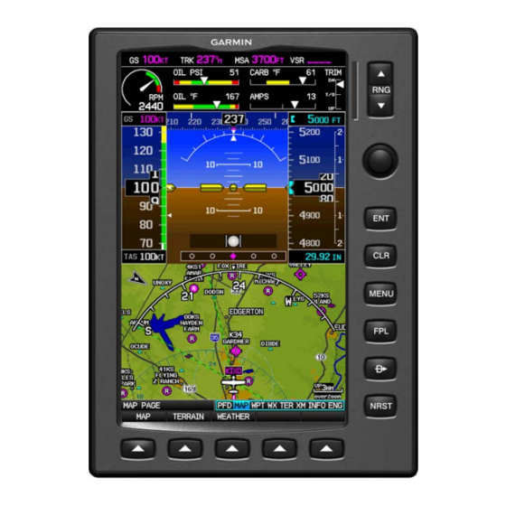
Garmin G300 for Cessna SkyCatcher Pilot's Manual (9 pages)
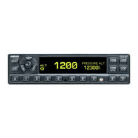
Mode A/C Transponder
Brand:
Garmin
| Category:
Marine Radio
| Size: 0 MB
Table of Contents
Software License Agreement
2
Limited Warranty
3
Mode Selection Keys
4
Code Selection
4
Keys for Other GTX 327 Functions
5
Function Display
6
Altitude Trend Indicator
6
Automatic ALT/STBY Mode Switching
6
ADS-B Control (GDL 90)
6
Timer Operation
7
Advertisement
Related Products
Garmin APPROACH G30
Garmin Approach G3
Garmin Beechcraft G36
Garmin G3X Touch
Garmin G3X MFD
Garmin G3X TOUCH Single 10
Garmin Personal Navigator GPS 45XL
Garmin G900X
Garmin GPS 16x
Garmin GNC 300TSO
Garmin Categories
GPS
Watch
Car Navigation system
Avionics Display
Marine Equipment
More Garmin Manuals
Login
Sign In
OR
Sign in with Facebook
Sign in with Google
Upload manual
Upload from disk
Upload from URL