Garmin G300 Pilot's Manual
Hide thumbs
Also See for G300:
- Pilot's manual (296 pages) ,
- Installation manual (120 pages) ,
- User manual (22 pages)
Table of Contents
Advertisement
Quick Links
Download this manual
See also:
Installation Manual
Advertisement
Table of Contents

Related Manuals for Garmin G300


Summary of Contents for Garmin G300
- Page 1 G300 Pilot’s Guide...
- Page 3 SyStem Overview Flight inStrumentS COm interFaCe gPS navigatiOn Flight Planning hazard avOidanCe additiOnal FeatureS integrated autOPilOt annunCiatiOnS & alertS aPPendix index...
- Page 5 Garmin Ltd. or its ® ® ® subsidiaries. These trademarks may not be used without the express permission of Garmin. Jeppesen is a registered trademark of Jeppesen, Inc. ® is a registered trademark of XM Satellite Radio, Inc.
- Page 6 G300 PFD when determining or selecting aircraft altitude. WARNING: Do not use outdated database information. Databases used in the G300 system must be updated regularly in order to ensure that the information remains current. Pilots using any outdated database do so entirely at their own risk.
- Page 7 Although unlikely, it may be possible for erroneous operation to occur without a fault indication shown by the G300. It is thus the responsibility of the pilot to detect such an occurrence by means of cross-checking with all redundant or correlated information available in the cockpit.
- Page 8 FAA/FCC regulations. NOTE: All visual depictions contained within this document, including screen images of the G300 panel and displays, are subject to change and may not reflect the most current G300 system and aviation databases.
- Page 9 This notice is being provided in accordance with California’s Proposition 65. If you have any questions or would like additional information, please refer to our web site at www.garmin.com/ prop65. NOTE: Interference from GPS repeaters operating inside nearby hangars can cause an intermittent loss of attitude and heading displays while the aircraft is on the ground.
- Page 10 Cautions & notes Blank Page Garmin G300 Pilot’s Guide 190-00921-00 Rev. D...
- Page 11 Added ability to display checklist files from SD Card • Added ability to log data to SD Card • Added ability to export Track Log and User Waypoints to SD Card September, Clerical Changes 2010 RR-1 190-00921-00 Rev. D Garmin G300 Pilot’s Guide...
- Page 12 Blank Page RR-2 Garmin G300 Pilot’s Guide 190-00921-00 Rev. D...
-
Page 13: Table Of Contents
Contents Section 1 System Overview ..............1 1.1 line replaceable units ................1 G300 Standard Panel (Single Display) ..............4 G300 Upgraded Panel (Dual Display) ...............5 1.2 display Overview ..................6 1.3 Secure digital (Sd) Cards ................7 1.4 g300 Controls ....................8 1.5 System Power-up .................. - Page 14 5.6 direct-to navigation ................107 Section 6 Flight Planning ..............111 6.1 introduction ....................111 Flight Plan Data Fields ..................112 6.2 Flight Plan Creation ................. 113 6.3 Flight Plan Storage .................. 115 6.4 Flight Plan activation ................116 Garmin G300 Pilot’s Guide 190-00921-00 Rev. D...
- Page 15 8.6 electronic Checklists (Optional) .............. 176 8.7 Flight data logging ................. 177 Section 9 integrated autopilot (Optional) ........179 9.1 integrated autopilot Operation ............. 180 Controls ......................180 G300 Autopilot Status BOX .................183 Integrated Autopilot Modes .................185 190-00921-00 Rev. D Garmin G300 Pilot’s Guide...
- Page 16 Proximity Waypoints ....................229 appendix C: Sd Card use and databases ............. 231 Installing and Removing SD Cards ...............231 G300 Databases ....................232 Updating G300 Databases ..................235 Exporting Track Logs and User Waypoints .............237 Importing/Exporting Flight Plans ................238 Flight Data Logging .....................238 appendix d: map datum and location Formats .........
- Page 17 Contents appendix e: abnormal operation ..............241 Loss of GPS Position ....................241 G300 System Failure Annunciations ..............242 Unusual Attitudes ....................243 Reversionary Mode (Dual Display) ................243 Synthetic Vision Troubleshooting ................244 appendix F: display Symbols ................ 245 VFR Symbols .......................245 IFR Symbols ......................246...
- Page 18 Contents Blank Page Garmin G300 Pilot’s Guide 190-00921-00 Rev. D...
-
Page 19: Section 1 System Overview
System Overview SeCtiOn 1 SyStem Overview The G300 System presents flight instrumentation, position, navigation, communication, and identification information to the pilot using one (single display) or two (dual display) 7” Wide VGA (800x480) flat-panel color display(s). 1.1 line rePlaCeaBle unitS The system is distributed across the following Line Replaceable Units (LRUs): •... -
Page 20: System Overview
System Overview • GSU 73 Garmin Sensor Unit sub-system for the G300 (Air Data Computer (ADC), – Engine/Airframe Unit, and the Attitude and Heading Reference System (AHRS)) – ADC: Processes data from the pitot-static system and outside air temperature (OAT) sensor. - Page 21 AHRS for processing to determine aircraft magnetic heading. This unit receives power directly from the AHRS and communicates with it via an RS-485 digital interface. GMU 44 • GTP 59 Temperature Probe: Provides raw air temperature data. – GTP 59 190-00921-00 Rev. D Garmin G300 Pilot’s Guide...
-
Page 22: G300 Standard Panel (Single Display)
System Overview g300 Standard Panel (Single diSPlay) In the standard ‘single display’ configuration, the Primary Flight Display (PFD) and the Multi Function Display (MFD) share a single GDU. GDU 370 or 375 (XM) Split PFD/MFD GSU 73 Garmin Sensor Unit... -
Page 23: G300 Upgraded Panel (Dual Display)
System Overview g300 uPgraded Panel (dual diSPlay) With the upgraded ‘dual display’ configuration the left GDU is configured as a PFD and the right GDU is configured as a MFD. GDU 375 (MFD) GDU 370 (PFD) GSU 73 Garmin Sensor Unit... -
Page 24: Display Overview
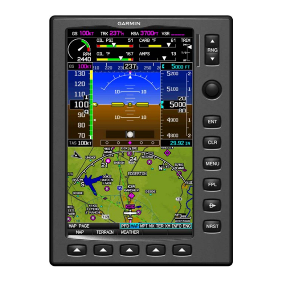
System Overview 1.2 diSPlay Overview 7” WVGA (800x480) SD Card Slot Color Display Range (RNG) Key FMS Joystick Display Bezel Hardkeys Softkeys Unit Overview (Single Display-Map Page) Garmin G300 Pilot’s Guide 190-00921-00 Rev. D... -
Page 25: Secure Digital (Sd) Cards
Refer to Appendix C for more information on SD Card use and databases. The G300 data card slot uses Secure Digital (SD) cards and is located on the upper right side of the display bezel(s). The SD card can be used for software updates, checklist files, flight data logging, exporting Track Logs/User Waypoints, and Importing/Exporting Flight Plans. -
Page 26: G300 Controls
FMS Joystick to sync to the current heading With the appropriate autopilot mode selected, move the FMS Joystick (up/down) to adjust the vertical mode reference for Vertical Speed, Altitude Hold, and Pitch Hold modes. Garmin G300 Pilot’s Guide 190-00921-00 Rev. D... - Page 27 NRST Key Press to display the Nearest Page for viewing the nearest airports, intersections, NDBs, VORs, waypoints, frequencies, and airspaces Softkey Press to select softkey shown above the bezel key on the display Selection Keys 190-00921-00 Rev. D Garmin G300 Pilot’s Guide...
-
Page 28: System Power-Up
When this information has been reviewed for currency (to ensure that no databases have expired), the pilot is prompted to continue. Pressing the ENT Key acknowledges this information. Database Information Garmin G300 Pilot’s Guide 190-00921-00 Rev. D... -
Page 29: System Operation
System Overview 1.6 SyStem OPeratiOn This section discusses normal and reversionary G300 display operation, G300 System Annunciations, and AHRS Operation. diSPlay OPeratiOn In normal operating mode, the PFD presents graphical flight instrumentation (attitude, heading, airspeed, altitude, vertical speed), replacing the traditional flight instrument cluster. - Page 30 Dual Display ( Reversionary Mode) In the event of a display failure, the G300 System automatically switches to reversionary (backup) mode. In reversionary mode, all information is presented on the remaining display in the same format as the Single Display system.
-
Page 31: G300 System Annunciations
Abnormal Operation). Upon G300 power-up, certain instruments remain invalid as equipment begins to initialize. All instruments should be operational within one minute of power-up. If any instrument remains flagged, the G300 should be serviced by an authorized repair facility. PFD Initialization... -
Page 32: Gps Data
GPS failure results in loss of all attitude and heading information. Likewise, loss of magnetometer (heading) data, in combination with loss of GPS data results in a loss of all attitude and heading information. Garmin G300 Pilot’s Guide 190-00921-00 Rev. D... -
Page 33: Accessing System Functionality
Flight Log and Track Log Main Menu options must be accessed from the MFD in a multiple display system. The G300 has a dedicated MENU Key that when pressed once displays a context-sensitive list of options for the page (Page Menu) or the PFD (dual display), and when pressed twice displays the Main Menu. - Page 34 4) Press the FMS Joystick, CLR Key, EXIT Softkey, or press the MENU Key to remove the menu and cancel the operation. Main Menu (Single Display) Main Menu (Dual Display - PFD) Main Menu (Dual Display - MFD) Garmin G300 Pilot’s Guide 190-00921-00 Rev. D...
-
Page 35: Data Entry
The FMS Joystick can be used for directly entering alphanumeric data into the G300. In some instances, such as when entering an identifier, the G300 tries to predict the desired identifier based on the characters being entered. In this case, if the desired identifier appears, use the ENT Key to confirm the entry without entering the rest of the identifier manually. - Page 36 FMS Joystick to move the cursor, until the fields are complete. d) Press the ENT Key to confirm entry. Press the FMS Joystick or the CLR Key to cancel data entry (the field reverts back to its previous information). Garmin G300 Pilot’s Guide 190-00921-00 Rev. D...
- Page 37 Selected Page Input Focus on Page Navigation Bar Active Page Title (Page Cursor Off) Input Focus on Current Page (Page Cursor On) Page Navigation (Single Display) 190-00921-00 Rev. D Garmin G300 Pilot’s Guide...
-
Page 38: Main Pages
1) If necessary, press the FMS Joystick to begin interaction with the Page Navigation Bar. 2) Turn the FMS Joystick until the desired page is selected (PFD (single display), MAP, WPT, WX, TER, XM, INFO, ENG). Garmin G300 Pilot’s Guide 190-00921-00 Rev. D... - Page 39 PFD Page (PFD) (single display) Terrain Page (TER) Map Page (MAP) XM Audio Page (XM) (optional) Waypoint Page (WPT) Info Page (INFO) Weather Page (WX) (optional) Engine Page (ENG) Main Pages (Single Display) 190-00921-00 Rev. D Garmin G300 Pilot’s Guide...
- Page 40 ATC (Air Route Traffic Control Center) —bearing, distance, and frequency. • FSS (Flight Service Station) —name, bearing, distance, frequency, and VOR (if applicable). • ASPC (Airspace) —name, time to entry (when applicable), and status. Garmin G300 Pilot’s Guide 190-00921-00 Rev. D...
- Page 41 Nearest Airport Weather (WX) (375) Nearest Cities (CTY) Nearest VORs (VOR) Nearest ARTCC (ATC) Nearest NDBs (NDB) Nearest FSS (FSS) Nearest Intersections (INT) Nearest Airspace (ASPC) Visual Reporting Point (VRP) (Atlantic) Nearest Pages (Single Display) 190-00921-00 Rev. D Garmin G300 Pilot’s Guide...
-
Page 42: Main Page Softkeys
When a softkey function is disabled, the softkey label is subdued (dimmed). Softkey Softkey Names (Displayed) Bezel Mounted Softkeys (Press) Softkeys (WPT Page) Garmin G300 Pilot’s Guide 190-00921-00 Rev. D... - Page 43 CDI SRC Toggles between available NAV sources (when configured) BARO Allows the pilot to adjust the barometric pressure setting ALT/PTCH Allows the pilot to adjust the selected altitude and displays vertical mode softkeys 190-00921-00 Rev. D Garmin G300 Pilot’s Guide...
- Page 44 Selects/deselects vertical speed mode AP ALT Selects/deselects altitude hold mode ALT/PTCH Initial press allows the pilot to adjust the selected altitude and displays the vertical mode softkeys; subsequent press returns to top-level softkeys Garmin G300 Pilot’s Guide 190-00921-00 Rev. D...
-
Page 45: Map Page Softkeys
Returns to top-level softkeys IFR MAP Softkey selected VFR MAP Displays VFR map information and softkeys LOW AWY Low Altitude (Victor) Airways displayed HIGH AWY High Altitude Airways (Jet Routes) displayed BACK Returns to top-level softkeys 190-00921-00 Rev. D Garmin G300 Pilot’s Guide... -
Page 46: Waypoint Page Softkeys
WEATHER PAGE SOFTKEyS (OPTIONAL) PAN MAP ANIMATE INFO LEGEND PAN MAP Activates the map pointer for panning the map ANIMATE Animates NEXRAD Radar and Satellite Mosaic weather INFO Displays XM Information LEGEND Displays weather legends Garmin G300 Pilot’s Guide 190-00921-00 Rev. D... - Page 47 VOL - BACK VOL + MUTE VOL - Decreases XM audio volume VOL + Increases XM audio volume MUTE Toggles XM audio on/off BACK Returns to top-level softkeys 190-00921-00 Rev. D Garmin G300 Pilot’s Guide...
-
Page 48: Flight Planning Softkeys
Displays the ‘Activate Flight Plan?’ Window Displays the ‘New Flight Plan’ Window IMPORT Displays the available flight plans to import from the SD Card EXPORT Exports the selected flight plan EXIT Exits the Flight Plan Pages Garmin G300 Pilot’s Guide 190-00921-00 Rev. D... -
Page 49: Nearest Page Softkeys
Internal system checking is performed to ensure the GPS receiver is providing accurate data to the GDU(s). In the G300 Dual Display System the GPS antenna is connected to the PFD only. The PFD shares its GPS position, velocity, and time data with the MFD. Because the MFD is not using its own GPS receiver, the name of the GDU providing the data (i.e., ‘3D GPS Location (PFD)’) is displayed following the GPS Status text on... - Page 50 • Lost Satellite Reception—the receiver is no longer tracking enough satellites for a 2D or 3D fix GPS Status, Position, and Data Fields (Dual Display only) can be accessed from the Information Page. INFO Page (Single Display) Garmin G300 Pilot’s Guide 190-00921-00 Rev. D...
-
Page 51: New Location
ENT Key. 4) After selecting your approximate position using the map pointer or entering an identifier, press the ENT Key. 5) The GPS Receiver will begin a new search based on the location entered. 190-00921-00 Rev. D Garmin G300 Pilot’s Guide... -
Page 52: Acquiring Satellites
- No bar—Receiver is looking for the indicated satellite - Gray bar—Receiver has collected the necessary data and the satellite signal can be used - Green bar—Satellite is being used for the GPS solution Garmin G300 Pilot’s Guide 190-00921-00 Rev. D... -
Page 53: Position
ENT Key. 3) Move the FMS Joystick to highlight the desired nearest type option (Automatic, Airport, VOR, NDB, Intersection, City, Waypoint), and press the ENT Key. INFO Page Menu Nearest Type Menu 190-00921-00 Rev. D Garmin G300 Pilot’s Guide... -
Page 54: Data Fields And Layout (Dual Display - Mfd)
4) Turn the FMS Joystick to access a list of available Data Field options. 5) Turn or move the FMS Joystick to highlight the desired Data Field, and press the ENT Key. INFO Page Menu Data Field Options Garmin G300 Pilot’s Guide 190-00921-00 Rev. D... -
Page 55: System Settings
3) Turn or move the FMS Joystick to highlight the desired menu option (Data Bar Fields, Display, Date & Time, Position, or Alarms), and press the ENT Key. 4) Press the MENU Key. 190-00921-00 Rev. D Garmin G300 Pilot’s Guide... -
Page 56: Data Bar Fields
The Dual Display MFD and PFD Data Bar Fields are independently configured from each display. Data Bar Data Bar (PFD Page - Single Display) Data Bar Fields Data Bar Setup Page (Single Display) Garmin G300 Pilot’s Guide 190-00921-00 Rev. D... -
Page 57: Display
With ‘Manual’ selected, the pilot can manually adjust the desired backlight intensity (1-10). The system reverts to the default ‘Auto’ mode after each power cycle. Display Setup Page (Single Display) 190-00921-00 Rev. D Garmin G300 Pilot’s Guide... -
Page 58: Sound
The pilot can manually adjust the desired XM Volume (0-10) or Message Volume (Off or 1-10). Message Volume controls the banner message tones (e.g., “Approaching Airspace” or “Arriving at Waypoint”). Sound Setup Page (Single Display) Garmin G300 Pilot’s Guide 190-00921-00 Rev. D... -
Page 59: Units
FMS Joystick. 5) Press the FMS Joystick, the CLR Key, the EXIT Softkey or the MENU Key to return to the previous page. Units Setup Page (Single Display) 190-00921-00 Rev. D Garmin G300 Pilot’s Guide... -
Page 60: Date & Time
Date & Time Setup Page (Single Display) POSitiOn nOte: Refer to Appendix D for more information on Map Datums and Location Formats. nOte: ‘Heading’ and ‘Mag. Variation’ settings have no effect on the HSI or the Heading Tape. Garmin G300 Pilot’s Guide 190-00921-00 Rev. D... -
Page 61: Alarms
4) Move the FMS Joystick to highlight the desired field, and select the desired option by turning the FMS Joystick. 5) Press the FMS Joystick, the CLR Key, the EXIT Softkey or the MENU Key to remove the menu. 190-00921-00 Rev. D Garmin G300 Pilot’s Guide... -
Page 62: Setting Airport Criteria
Water Only: Shows only water landing facilities. • Minimum Runway Length: Allows the pilot to enter a specific length for the shortest runway allowed. • Include Private Airports: Allows the pilot include Private Airports in the search criteria. Garmin G300 Pilot’s Guide 190-00921-00 Rev. D... - Page 63 4) Turn or move the FMS Joystick to select ‘Set Airport Criteria’, and then press the ENT Key. A window appears with the current settings. 5) Press the MENU Key. 6) With ‘Restore Default’ highlighted press the ENT Key. 190-00921-00 Rev. D Garmin G300 Pilot’s Guide...
- Page 64 System Overview Blank Page Garmin G300 Pilot’s Guide 190-00921-00 Rev. D...
-
Page 65: Section 2 Flight Instruments
Press the FMS Joystick if necessary to begin interaction with the Page Navigation Bar. 2) Turn the FMS Joystick to select the PFD Page. The following flight instruments and supplemental flight data are displayed on the PFD and/or PFD Page (single display system). 190-00921-00 Rev. D Garmin G300 Pilot’s Guide... - Page 66 System Time Turn Rate Indicator Horizontal Situation Indicator ( HSI) Current Heading Course Deviation Indicator (CDI) Scale Current Track Indicator (Heading Strip) Selected Course Selected Heading Bug Slip/Skid Indicator Attitude Indicator Altimeter Barometric Setting Garmin G300 Pilot’s Guide 190-00921-00 Rev. D...
-
Page 67: Airspeed Indicator
Ground Speed Flaps 10° Tick Mark Flaps 25° Tick Mark Airspeed Trend Vector Actual Airspeed Vspeed References Airspeed Color Ranges True Airspeed Airspeed Indicator 190-00921-00 Rev. D Garmin G300 Pilot’s Guide... -
Page 68: Attitude Indicator
30˚ and 60˚ and minor tick marks at 10˚, 20˚, and 45˚ are shown to the left and right of the zero. Angle of bank is indicated by the position of the pointer on the roll scale. Slip/skid is indicated by the location of the ball. Garmin G300 Pilot’s Guide 190-00921-00 Rev. D... -
Page 69: Altimeter
A bug corresponding to this altitude is shown on the tape; if the Selected Altitude exceeds the range shown on the tape, the bug appears at the corresponding edge of the tape. 190-00921-00 Rev. D Garmin G300 Pilot’s Guide... -
Page 70: Setting The Selected Altitude
1) From the PFD Page (one display) or PFD (two display), press the BARO Softkey to highlight the barometric pressure setting. 2) Turn the FMS Joystick to display the desired barometric pressure setting and press the ENT Key. Garmin G300 Pilot’s Guide 190-00921-00 Rev. D... -
Page 71: Altitude Alerting
3) Turn or move the FMS Joystick to highlight ‘Sound’, and press the ENT Key. 4) Move the FMS Joystick to highlight the Altitude Alert field, and select ‘On/Off’ by turning the FMS Joystick. 190-00921-00 Rev. D Garmin G300 Pilot’s Guide... -
Page 72: Vertical Speed Indicator (Vsi)
The HSI also presents course deviation, bearing, and navigation source information. The Selected Heading is shown to the left of the HSI The light blue bug on the compass rose corresponds to the Selected Heading. Garmin G300 Pilot’s Guide 190-00921-00 Rev. D... - Page 73 To/From Indicator Current Track Indicator Aircraft Symbol Course Pointer Lateral Deviation Scales Navigation Source Selected Heading Bug Course Deviation Indicator Course Deviation & To/From (CDI) Indicator Rotating Compass Rose Horizontal Situation Indicator (HSI) 190-00921-00 Rev. D Garmin G300 Pilot’s Guide...
- Page 74 CDI scale = 0.25 nm - on an approach leg or within 2 nm of the FAF or MAP. • CDI scale = 5.0 nm - if the previous two conditions do not exist. Garmin G300 Pilot’s Guide 190-00921-00 Rev. D...
-
Page 75: Bearing Pointers And Information Windows
The Bearing Information Windows are displayed at the lower sides of the HSI. The following information may be displayed in the Bearing Information Windows: • Bearing source (GPS) • Station/waypoint identifier (GPS) • Pointer icon • GPS-derived great circle distance to bearing source 190-00921-00 Rev. D Garmin G300 Pilot’s Guide... - Page 76 3) Move the FMS Joystick to highlight the desired Bearing Pointer. 4) Turn the FMS Joystick to highlight the desired source, or to remove the bearing pointer and information window, highlight ‘Off’. Set Bearing Pointer Garmin G300 Pilot’s Guide 190-00921-00 Rev. D...
-
Page 77: Heading Strip And Turn Rate Indicator
When OBS Mode is disabled, the GPS flight plan returns to normal operation with automatic sequencing of waypoints, following the course set in OBS Mode. The flight path on the moving map retains the modified course line. 190-00921-00 Rev. D Garmin G300 Pilot’s Guide... - Page 78 MENU Key, with ‘Release Hold’ highlighted, press the ENT Key. The OBS Softkey returns to the subdued CRS Softkey. PFD or PFD Page Menu PFD or PFD Page Menu (Set OBS Mode) (Release OBS Mode) Garmin G300 Pilot’s Guide 190-00921-00 Rev. D...
-
Page 79: Supplemental Flight Data
Skip to step 3 if at least one external navigator is configured. 3) Move the FMS Joystick to highlight the Wind Vector field. 4) Turn the FMS Joystick to highlight ‘On’ or ‘Off’. 190-00921-00 Rev. D Garmin G300 Pilot’s Guide... -
Page 80: Vertical Navigation (Vnav)
(Required Vertical Speed Indicator (RVSI)) on the Vertical Speed Indicator indicates the required vertical speed to reach the target altitude. The Vertical Navigation feature is only available when navigating a Direct-to or flight plan, and the ground speed is greater than 35 knots. Garmin G300 Pilot’s Guide 190-00921-00 Rev. D... -
Page 81: Using The Vnav Feature
The magenta VNAV Indicator appears on the PFD. A message appears when approaching the VNAV Profile. When the VNAV Indicator is in the vertical center of the Vertical Deviation Scale, the aircraft is at the proper altitude for the VNAV Profile. 190-00921-00 Rev. D Garmin G300 Pilot’s Guide... - Page 82 2) Turn the FMS Joystick to select the Vertical Navigation Page. 3) Press the FMS Joystick to activate the cursor. 4) Enter the desired profile into the fields, and press the EXIT Softkey. Vertical Navigation Page (Single Display) Garmin G300 Pilot’s Guide 190-00921-00 Rev. D...
- Page 83 Profile’ centers the VNAV indicator (must be navigating a Flight Plan or Direct-to). If the VNAV Profile is canceled, the VNAV Indicator, Vertical Deviation Scale and the Required Vertical Speed Indicator (RVSI) are removed from the PFD. 190-00921-00 Rev. D Garmin G300 Pilot’s Guide...
- Page 84 Flight instruments Blank Page Garmin G300 Pilot’s Guide 190-00921-00 Rev. D...
-
Page 85: Section 3 Engine Indication System
SeCtiOn 3 engine indiCatiOn SyStem 3.1 eiS diSPlay & eng Page The G300 Engine Indication System (EIS) displays critical engine, electrical, and other system parameters on the top portion of the display (single display & dual display MFD). Additional EIS information can be viewed by selecting the ENG Page. - Page 86 Exhaust Gas Temperature Displays the Exhaust Gas Temperature Indicator (EGT °F) in °F Voltmeter Displays the main bus voltage Total Hours (HRS) Time is recorded whenever RPM > 10 20 600. Garmin G300 Pilot’s Guide 190-00921-00 Rev. D...
- Page 87 If sensory data to an instrument becomes invalid or unavailable, a red “X” is displayed across the instrument. 190-00921-00 Rev. D Garmin G300 Pilot’s Guide...
- Page 88 Blank Page Garmin G300 Pilot’s Guide 190-00921-00 Rev. D...
-
Page 89: Section 4 Com Interface
3) From the Nearest ARTCC or Nearest FSS, move the FMS Joystick to highlight the desired frequency. Nearest ARTCC (Single Display) Nearest FSS (Single Display) a) From the Nearest Airport Weather Page, highlight the desired airport weather, and press the ENT Key. 190-00921-00 Rev. D Garmin G300 Pilot’s Guide... - Page 90 4) Press the ENT Key to load the frequency into the standby field of the SL40. If the frequency has an * (additional information available) next to it, press the ENT Key a second time with ‘Tune’ highlighted. Frequency with Additional Information (Single Display) Garmin G300 Pilot’s Guide 190-00921-00 Rev. D...
- Page 91 3) Press the ENT Key to load the frequency into the standby field of the SL40. If the frequency has an * (additional information available) next to it, press the ENT Key a second time with ‘Tune’ highlighted. 190-00921-00 Rev. D Garmin G300 Pilot’s Guide...
- Page 92 COm interface Blank Page Garmin G300 Pilot’s Guide 190-00921-00 Rev. D...
-
Page 93: Section 5 Gps Navigation
The compass arc is not available in ‘North Up’ map orientation. A compass arc representing the aircraft’s ground track, appears by default on the Map Page. The route line represents the course. Compass Arc Route Line Compass Arc (Map Page) 190-00921-00 Rev. D Garmin G300 Pilot’s Guide... -
Page 94: Using Map Displays
6) Turn or move the FMS Joystick to highlight ‘Off’, and press the ENT Key. 5.2 uSing maP diSPlayS Map displays are used extensively in the G300 to provide situational awareness in flight. Most G300 maps can display the following information: • Airports, NAVAIDs, airspaces, airways, land data (highways, cities, lakes, rivers, borders, etc.) with names... -
Page 95: Map Page Setup
Turn the FMS Joystick to access a list of available options. c) Turn or move the FMS Joystick to highlight ‘North Up’, ‘Track Up’, or ‘DTK Up’, and press the ENT Key. 190-00921-00 Rev. D Garmin G300 Pilot’s Guide... -
Page 96: Gps Navigation
6) Using the FMS Joystick select the desired option and press the ENT Key. 7) Press the FMS Joystick, the CLR Key, or the EXIT Softkey to return to the Map Page with the changed settings. Garmin G300 Pilot’s Guide 190-00921-00 Rev. D... - Page 97 6) Using the FMS Joystick select the desired option and press the ENT Key. 7) Press the FMS Joystick, the CLR Key, or the EXIT Softkey to return to the Map Page with the changed settings. Map Setup Page (City Category) Map Setup Page (Road Category) 190-00921-00 Rev. D Garmin G300 Pilot’s Guide...
- Page 98 7) Press the FMS Joystick, the CLR Key, or the EXIT Softkey to return to the Map Page with the changed settings. Map Setup Page (Airspace Category) Map Setup Page (Airspace Category - Atlantic) Map Setup Page (SUA Category) Garmin G300 Pilot’s Guide 190-00921-00 Rev. D...
-
Page 99: Map Range
4) Move the FMS Joystick to highlight the ‘Autozoom’ field. 5) Turn the FMS Joystick to access the ‘On/Off’ drop down list. 6) Turn or move the FMS Joystick to highlight the desired option, and press the ENT Key. 190-00921-00 Rev. D Garmin G300 Pilot’s Guide... -
Page 100: Map Panning
If multiple features are present at the Map Pointer position, a green arrow will appear in the information box. Turning the FMS Joystick will cycle through the list of map features present at that position. Garmin G300 Pilot’s Guide 190-00921-00 Rev. D... -
Page 101: Panning The Map
2) Press the ENT Key to display the review page for the highlighted feature. 3) Press the FMS Joystick, the CLR Key, or the ENT Key to exit the review page and return to the Map Page showing the selected waypoint. 190-00921-00 Rev. D Garmin G300 Pilot’s Guide... -
Page 102: Measuring Bearing And Distance
4) To exit the Measure Bearing/Distance option, press the FMS Joystick; or select ‘Stop Measuring’ from the Page Menu and press the ENT Key. Reference Point Measurement Line Map Pointer Map Page Menu Map Page (Measure Distance) Garmin G300 Pilot’s Guide 190-00921-00 Rev. D... -
Page 103: Topography
4) Move the FMS Joystick to highlight the ‘Topo Shading’ field. 5) Turn the FMS Joystick to select ‘On’ or ‘Off’, and press the ENT Key. VFR MAP TOPO Softkey Softkey Topographic Data (Map Page) (Single Display) 190-00921-00 Rev. D Garmin G300 Pilot’s Guide... -
Page 104: Satellite View
5) Turn the FMS Joystick to select ‘On’ or ‘Off’, and press the ENT Key. VFR MAP SAT VIEW Softkey Softkey Satellite View (Map Page) (Single Display) maP SymBOlS Refer to Appendix F for a list of map symbols. Garmin G300 Pilot’s Guide 190-00921-00 Rev. D... -
Page 105: Airways
18,000 feet MSL and extend upward to 45,000 feet MSL (altitudes above 18,000 feet are called “flight levels” and are described as FL450 for 45,000 feet MSL). Jet Routes are designated with a “J” before the route number. 190-00921-00 Rev. D Garmin G300 Pilot’s Guide... -
Page 106: Displaying/Removing Airways
3) With the LOW AWy and/or HIGH AWy Softkeys selected, press the FMS Joystick to display the Map Pointer. 4) Place the Map Pointer on an airway. The MEA, name of airway, endpoints, distance, and calculated radials are displayed. Garmin G300 Pilot’s Guide 190-00921-00 Rev. D... - Page 107 5) Press the ENT Key to display the review page for the airway. Low Altitude Airway Review Page (Single Display) 6) Press the FMS Joystick, the CLR Key, or the ENT Key to exit the review page and return to the Map Page. 190-00921-00 Rev. D Garmin G300 Pilot’s Guide...
-
Page 108: Waypoints
The Waypoint Page allows the pilot to review airport information, runway information, frequencies, instrument procedures, AOPA information, and weather information. The pilot can manually enter the identifier or the G300 will choose the most appropriate identifier based on the current position and phase of flight. -
Page 109: Automatic Waypoint Selection
INFO Softkey Selected Waypoint Page (INFO Softkey Selected) (Single Display) Runway Information -Designation -Length/Width -Surface Showing -Lighting Selected -Traffic Pattern Waypoint -Wind (Dual) RUNWAY Softkey Selected Waypoint Page (RUNWAy Softkey Selected) (Single Display) 190-00921-00 Rev. D Garmin G300 Pilot’s Guide... - Page 110 (turning it counter-clockwise brings up the waypoint selection submenu - press the CLR Key or the FMS Joystick to remove it), or move the FMS Joystick to select the facility name, or city field. 4) Press the ENT Key. Garmin G300 Pilot’s Guide 190-00921-00 Rev. D...
-
Page 111: Selecting A Runway
5) Press the RUNWAy Softkey (Single Display only). 6) Press the FMS Joystick to activate the cursor (Single Display only). 7) Move the FMS Joystick to place the cursor in the ‘Runway’ Box, on the runway designator. 190-00921-00 Rev. D Garmin G300 Pilot’s Guide... - Page 112 1) With the Waypoint (WPT) Page displayed, press the INFO Softkey. 2) Press the FMS Joystick to activate the cursor. 3) Move the FMS Joystick to place the cursor in the ‘Frequencies’ Box, on the frequency denoted with an *. Garmin G300 Pilot’s Guide 190-00921-00 Rev. D...
-
Page 113: Nearest Information
5) To remove the window, press the FMS Joystick, ENT Key, or CLR Key. neareSt inFOrmatiOn The G300 provides a NRST Key which gives the pilot quick access to nearest airport, weather, VOR, NDB, intersection, user waypoint, city, ARTCC, FSS, and airspace information. -
Page 114: Nearest Airports Page
3) Press the ENT Key. The Airport Criteria Window is displayed. 4) Move the FMS Joystick to select the desired criteria to be defined. 5) Turn the FMS Joystick to select the desired option. 6) Press the ENT Key. Garmin G300 Pilot’s Guide 190-00921-00 Rev. D... -
Page 115: Weather Information
4) Press the ENT Key. 1) Press the NRST Key. 2) Turn the FMS Joystick to select the Nearest Airport WX Page. If Nearest Airport Weather is not available, “None Within 200 NM” is displayed. 190-00921-00 Rev. D Garmin G300 Pilot’s Guide... -
Page 116: Intersections
(turning it counter-clockwise brings up the waypoint selection submenu - press the CLR Key or the FMS Joystick to remove it), or move the FMS Joystick to select the facility name, or city field. 4) Press the ENT Key. Garmin G300 Pilot’s Guide 190-00921-00 Rev. D... -
Page 117: Ndb S
2) Turn the FMS Joystick to select the Nearest NDBs Page. 3) Press the FMS Joystick to activate the cursor. 4) Turn the FMS Joystick to highlight the desired NDB. 5) Press the ENT Key to display the NDB Information Page. 190-00921-00 Rev. D Garmin G300 Pilot’s Guide... -
Page 118: Vors
2) Turn the FMS Joystick to select the Nearest VOR Page. 3) Press the FMS Joystick to activate the cursor. 4) Turn the FMS Joystick to highlight the desired VOR. 5) Press the ENT Key to display the VOR Information Page. Garmin G300 Pilot’s Guide 190-00921-00 Rev. D... -
Page 119: User Waypoints
The G300 can create and store up to 3,000 user-defined waypoints. Once a waypoint has been created, it can be renamed, deleted, or moved. Creating user waypoints: 1) To create a user waypoint at the current location, using the Map... - Page 120 REF WPTS Softkey to enter a bearing and distance from another waypoint or the bearing from two other waypoints to define the new waypoint location. Garmin G300 Pilot’s Guide 190-00921-00 Rev. D...
- Page 121 EDIT Softkey. The Edit Waypoint Window is displayed. 4) Move the cursor to the desired field(s) and make any necessary changes (to edit the Reference Waypoints, press the REF WPTS Softkey). 5) With ‘Done’ highlighted, press the ENT Key. 190-00921-00 Rev. D Garmin G300 Pilot’s Guide...
-
Page 122: Deleting User Waypoints
5) Press the DELETE Softkey. ‘No’ is highlighted in the confirmation window. 6) Highlight ‘Yes’ and press the ENT Key. User Waypoints can also be deleted by ‘Symbol’ or ‘Distance’ from the User Waypoints Page Menu. Garmin G300 Pilot’s Guide 190-00921-00 Rev. D... -
Page 123: Airspace
Option Menu, and press the ENT Key. 5.5 airSPaCe The G300 can display the following types of airspaces: Class B/TMA, Class C/ TCA, Class D, Restricted, MOA (Military), Other Airspace, Air Defense Identification Zone (ADIZ), and Temporary Flight Restriction (TFR). -
Page 124: Airspace Alert Messages
—Within two nautical miles of an airspace but not projected to enter • Near & Ahead —Project to enter the airspace within two nautical miles. • Inside Airspace —Within the boundaries of the airspace. Garmin G300 Pilot’s Guide 190-00921-00 Rev. D... -
Page 125: Smart Airspace
Once a direct-to is activated, the G300 establishes a point-to-point course line from the present position to the selected direct-to destination. Course guidance is provided until the direct-to is replaced with a new direct-to or flight plan, or cancelled. - Page 126 (RECENT WPTS), nearest airports (NRST APTS), and flight plan waypoints (FPL WPTS). 3) Move the FMS Joystick to select the desired waypoint. 4) Press the ENT Key. 5) With ‘Activate’ highlighted, press the ENT Key. Garmin G300 Pilot’s Guide 190-00921-00 Rev. D...
- Page 127 3) If the pointer is placed on an existing airport, NAVAID, or user waypoint, the waypoint name is highlighted. 4) Press the Direct-to Key to display the Direct-to Window with the selected point entered as the direct-to destination. 190-00921-00 Rev. D Garmin G300 Pilot’s Guide...
- Page 128 2) Move the FMS Joystick to highlight ‘Stop Navigation’ or ‘Resume Flight Plan’ if a flight plan was active. 3) Press the ENT Key. If a flight plan is still active, the G300 resumes navigating the flight plan. 1) Press the FPL Key.
-
Page 129: Section 6 Flight Planning
The active flight plan is erased when the destination is reached and the system is turned off. When storing flight plans with an approach, the G300 uses the waypoint information from the current database to define the waypoints. -
Page 130: Flight Plan Data Fields
5) Turn or Move the FMS Joystick to highlight the desired option from the list and press the ENT Key. First Data Second Data Third Data Field Field Field Data Field Selection (Active Flight Plan Page) Garmin G300 Pilot’s Guide 190-00921-00 Rev. D... -
Page 131: Flight Plan Creation
The active flight plan is listed on the Active Flight Plan Page. It is the flight plan to which the G300 is currently providing guidance, and is shown on the navigation maps. Stored flight plans are listed on the Flight Plan List Page, and are available for activation (becomes the active flight plan). -
Page 132: Flight Planning
6) Repeat steps 4 and 5 to enter each additional flight plan waypoint. 7) When all waypoints have been entered, press the FMS Joystick to return to the Flight Plan List Page. The new flight plan is now in the list. Garmin G300 Pilot’s Guide 190-00921-00 Rev. D... -
Page 133: Flight Plan Storage
Flight Planning 6.3 Flight Plan StOrage The G300 can store up to 50 flight plans. The active flight plan is erased when another flight plan is activated. Details about each stored flight plan can be viewed on the Flight Plan List Page Viewing information about a stored flight plan: 1) Press the FPL Key. -
Page 134: Flight Plan Activation
Activate Leg Window 5) With ‘Yes’ highlighted, press the ENT Key. To cancel the request, press the CLR Key, the FMS Joystick, or highlight ‘No’ and press the ENT Key. Garmin G300 Pilot’s Guide 190-00921-00 Rev. D... -
Page 135: Flight Plan Editing
2) Press the FMS Joystick to activate the cursor. 3) Using the FMS Joystick select the point in the flight plan before which to add the new waypoint. The new waypoint is placed directly in front of the highlighted waypoint. 190-00921-00 Rev. D Garmin G300 Pilot’s Guide... - Page 136 USE MAP Softkey to activate the map pointer. 3) Move the FMS Joystick to highlight the desired flight plan leg to be modified. Active Flight Plan Page (Flight Plan Leg Highlighted with Map Pointer) Garmin G300 Pilot’s Guide 190-00921-00 Rev. D...
-
Page 137: Editing Flight Plan Speed, Fuel, And/Or Name
2) Press the FMS Joystick to activate the cursor, and move the FMS Joystick to highlight the ‘Plan Fuel’ field. 3) Using the FMS Joystick, enter the desired plan fuel, and press the ENT Key. 190-00921-00 Rev. D Garmin G300 Pilot’s Guide... - Page 138 3) Move the FMS Joystick to the ‘Plan Speed’ field. 4) Using the FMS Joystick, enter the desired speed, and press the ENT Key. 5) Repeat steps 3 and 4 for ‘Plan Fuel’, and press the DONE Softkey. Garmin G300 Pilot’s Guide 190-00921-00 Rev. D...
- Page 139 3) Move the FMS Joystick to highlight the Flight Plan Name field. 4) Using the FMS Joystick, enter the flight plan name, and press the ENT Key. Editing the Saved Flight Plan Name 190-00921-00 Rev. D Garmin G300 Pilot’s Guide...
-
Page 140: Copying Flight Plans
Flight Planning COPying Flight PlanS The G300 allows copying a flight plan into a new flight plan memory slot, allowing editing, etc., without affecting the original flight plan. This can be used to duplicate an existing stored flight plan for use in creating a modified version of the original stored flight plan. -
Page 141: Deleting The Active Flight Plan
Waypoint’. The ‘Remove XXXXX From Flight Plan?’ window is displayed. Remove Waypoint Window 4) With ‘Yes’ highlighted, press the ENT Key. To cancel the request, press the CLR Key, the FMS Joystick, or highlight ‘No’ and press the ENT Key. 190-00921-00 Rev. D Garmin G300 Pilot’s Guide... -
Page 142: Inverting A Flight Plan
3) Move the FMS Joystick to highlight the desired flight plan, and press the ENT Key. The Saved Flight Plan Page is displayed. 4) Press the MENU Key, highlight ‘Invert Flight Plan?’, and press the ENT Key. Garmin G300 Pilot’s Guide 190-00921-00 Rev. D... -
Page 143: Importing/Exporting Flight Plans
3) Press the EXPORT Softkey and press the ENT Key. 6.6 aPPrOaCheS warning: The G300 is not designed to be independently used for flight into instrument meteorological conditions (IMC) or other conditions in which aircraft control is based solely upon flight instruments. The approaches provided are for monitoring purposes only. -
Page 144: Selecting An Approach
(GPS, RNAV, VOR, NDB, localizer, or ILS) and only the final course segment (final approach fix to missed approach point) of the published approach is available in the G300. An approach can be selected from the Direct-to Window, Waypoint (WPT) Page, Active Flight Plan Page, and the Saved Flight Plan Page. - Page 145 FMS Joystick to highlight the desired approach and press the ENT Key. 5) With ‘Activate Approach’ highlighted, press the ENT Key. To cancel the request, press the CLR Key or the FMS Joystick. 190-00921-00 Rev. D Garmin G300 Pilot’s Guide...
- Page 146 Approach Field. If an approach is already loaded or activated, ‘Activate’ is highlighted. 4) With ‘Activate’ highlighted press the ENT Key, or select an approach, highlight ‘Load Approach’ or ‘Activate Approach’, and press the ENT Key. Garmin G300 Pilot’s Guide 190-00921-00 Rev. D...
-
Page 147: Activating Vectors-To-Final
After an approach has been activated, the VECTORS Softkey is used when being vectored to the final approach course by Air Traffic Control (ATC). If the VECTORS Softkey is pressed, the G300 creates an extension of the final course, beyond the final approach waypoint in the database (final approach fix [FAF]). -
Page 148: Trip Planning
The map shows an extension of the final approach course using a bold magenta line. If the VECTORS Softkey is not pressed, the G300 creates a straight-line course directly to the first waypoint in the approach. Loading the approach cancels the Direct-to and initiates a route to the FAF. -
Page 149: Section 7 Hazard Avoidance
45-60 minutes or more, depending on the demand on the XM activation system. 4) Power on the avionics and allow the G300 to power up. Do not power cycle the units during the activation process. 5) Go to the XM Info Page. During the activation process the unit may display several different activation levels, this is normal and should be ignored. -
Page 150: Xm Satellite Weather Products
Composite data from all the NEXRAD radar sites in the United States is shown. This data is composed of the maximum reflectivity from the individual radar sweeps. The display of the information is color-coded to indicate the weather severity level. Garmin G300 Pilot’s Guide 190-00921-00 Rev. D... -
Page 151: Hazard Avoidance
An individual NEXRAD site cannot depict high altitude storms at close ranges, and has no information about storms directly over the site. • Radar coverage only extends to 55°N. • Any precipitation displayed between 52°N and 55°N is unknown. 190-00921-00 Rev. D Garmin G300 Pilot’s Guide... - Page 152 Echo Tops at or above the altitude you select are displayed, in 5,000 foot increments up to 70,000 ft. Echo Tops can be helpful in determining the severity of thunderstorms. Garmin G300 Pilot’s Guide 190-00921-00 Rev. D...
-
Page 153: Winds Aloft
A short wind flag is 5 knots, a long wind flag is 10 knots, and a triangle flag is 50 knots. Winds Aloft Data (Single Display) 190-00921-00 Rev. D Garmin G300 Pilot’s Guide... -
Page 154: Surface Pressure
Isobars that are packed closely together show a strong pressure gradient. Strong gradients are associated with areas of stronger winds. Pressure units can be displayed in Millibars (mb) and Inches of Mercury (in). Other Legend Surface Pressure Data Garmin G300 Pilot’s Guide 190-00921-00 Rev. D... -
Page 155: Storm Cells
(tops and intensity) can be viewed by selecting the storm cell with the map pointer. Pressing the ENT Key will display additional information. Storm Cell Data (Single Display) 190-00921-00 Rev. D Garmin G300 Pilot’s Guide... - Page 156 Select ‘Change Text Size’ and press the ENT Key. b) Select ‘Small’, ‘Medium’, or ‘Large’ and press the ENT Key. The METAR flag color is determined by the information in the METAR text. Garmin G300 Pilot’s Guide 190-00921-00 Rev. D...
- Page 157 In the contiguous United States, the following items are covered: severe icing, severe or extreme turbulence, volcanic ash, dust storms, and sandstorms that lower visibility to less than three statute miles. 190-00921-00 Rev. D Garmin G300 Pilot’s Guide...
- Page 158 TFRs are routinely issued for occurrences such as sporting events, dignitary visits, military depots, and forest fires. TFRs are represented as an area highlighted by red (active) or yellow (not yet active). TFR Data Garmin G300 Pilot’s Guide 190-00921-00 Rev. D...
-
Page 159: Freezing Levels
(UA) (blue) or Urgent (UUA) (yellow). Urgent (UUA) PIREP Routine (UA) PIREP Selected PIREP Data FREEzING LEVELS Freezing Level shows contours for the lowest forecast altitude where icing conditions are likely to occur. Freezing Level Data 190-00921-00 Rev. D Garmin G300 Pilot’s Guide... -
Page 160: Turbulence Forecast
SLD threat areas are depicted as magenta dots over the CIP colors. Moderate Icing Selected With Map Pointer Icing Forcast Legend (Single Display) Garmin G300 Pilot’s Guide 190-00921-00 Rev. D... - Page 161 Forecasts are available for intervals of 12, 24, 36, and 48 hours. Forecast Data (Single Display) Sunny Thunderstorms Windy Very Hot Partly Cloudy Rain Haze Mostly Cloudy Freezing Rain Foggy Cloudy Snow Very Cold Forecast Legend Fronts Legend 190-00921-00 Rev. D Garmin G300 Pilot’s Guide...
-
Page 162: Using Xm Satellite Weather Products
‘Weather Data’, ‘NEXRAD’, and/or ‘Fronts’ on the Map Page. Additional information about the following can be displayed by panning over the display on the Weather Page and the Map Page: • Storm Cells • METARs • SIGMETs • TFRs • AIRMETs Garmin G300 Pilot’s Guide 190-00921-00 Rev. D... - Page 163 (if available). 5) With the desired weather product selected press the ENT Key to get detailed information (if available). Abbreviated Weather Product Information Detailed Weather Product Information (Single Display) (Single Display) 190-00921-00 Rev. D Garmin G300 Pilot’s Guide...
- Page 164 6) With ‘Restore Default’ or ‘Restore All Map Defaults’ selected, press the ENT Key. 7) Press the FMS Joystick, the CLR Key, or the EXIT Softkey to return to the Map Page with the restored settings. Garmin G300 Pilot’s Guide 190-00921-00 Rev. D...
- Page 165 2) Using the FMS Joystick select either the ‘NEXRAD Radar’ or ‘Satellite Mosaic’ weather product. 3) Select the ANIMATE Softkey to begin animation a) Press the MENU Key. b) Select ‘Animate Weather’ and press the ENT Key to begin animation. 190-00921-00 Rev. D Garmin G300 Pilot’s Guide...
-
Page 166: Terrain
No terrain and obstacle information is shown without a valid 3-D GPS position. The G300 GPS receiver provides the horizontal position and altitude of the aircraft. Aircraft GPS altitude is derived from satellite position. GPS altitude is then converted to a mean sea level (MSL)-based altitude (GPS-MSL altitude) and is used to determine terrain and obstacle proximity. -
Page 167: Synthetic Vision
From the Map Page with the VFR Map displayed, press the TERRAIN Softkey. 1) From the Map Page, press the MENU Key. 2) Turn or move the FMS Joystick to highlight ‘Set Up Map’, and press the ENT Key. 190-00921-00 Rev. D Garmin G300 Pilot’s Guide... -
Page 168: Terrain Views
Red Terrain is above the aircraft, or within 100 ft below the aircraft. Potential Impact Point Obstacle Terrain Legend Terrain (TER) Page (Map View) (Single Display) Terrain (TER) Page (Profile View) (Single Display) Garmin G300 Pilot’s Guide 190-00921-00 Rev. D... -
Page 169: Obstacle Information
> 1000’ Points WARNING: Red obstacle is above or within 100’ below current aircraft altitude CAUTION: Yellow obstacle is between 100’ and 1000’ (default) below current aircraft altitude Terrain Obstacle Colors and Symbology 190-00921-00 Rev. D Garmin G300 Pilot’s Guide... -
Page 170: Terrain Alerts & Setup
Caution Elevation or user-defined Caution Elevation • Look Ahead Time —Determines the maximum time when an alert annunciation occurs. For example, if 120 seconds is selected, the G300 provides an alert up to 120 seconds before you reach the terrain or obstacle • Alert Sensitivity —The three Alert Sensitivity settings (Terrain, Obstacle, and... -
Page 171: Terrain Alerts
“terrain ahead! “obstacle ahead! pull “sink rate, pull pull up!” up!” up!” Warning “terrain! terrain! “obstacle! obstacle! “pull up!” pull up! pull up!” pull up! pull up!” Aural Alerts Summary 190-00921-00 Rev. D Garmin G300 Pilot’s Guide... - Page 172 Pop-up Alert Terrain Alerts Garmin G300 Pilot’s Guide 190-00921-00 Rev. D...
-
Page 173: Section 8 Additional Features
SafeTaxi diagrams provide detaled taxiway, runway, and ramp information at more than 700 airports in the United States. FlightCharts provide on-board electronic terminal procedure charts. Electronic charts offer the convenience of rapid access to essential information. 190-00921-00 Rev. D Garmin G300 Pilot’s Guide... -
Page 174: Synthetic Vision (Svx)
Synthetic Vision is a visual enhancement to the G300. Synthetic Vision depicts a forward-looking attitude display of the topography immediately in front of the aircraft. Synthetic Vision information is shown on the Primary Flight Display (PFD). -
Page 175: Additional Features
The following Synthetic Vision enhancements appear on the PFD: • Flight Path Marker • Terrain Alerting • Airport Signs • Obstacle Alerting • Runway Display • Zero-Pitch Line Synthetic Vision Imagery (PFD or PFD Page) 190-00921-00 Rev. D Garmin G300 Pilot’s Guide... -
Page 176: Synthetic Vision Operation
3) Move the FMS Joystick to highlight the ‘Flight Path Marker’ field. 4) Turn the FMS Joystick to highlight ‘On’ or ‘Off’. Synthetic Terrain Zero Pitch Line (ZPL) Airport Flight Runway Path Marker Synthetic Vision on PFD Garmin G300 Pilot’s Guide 190-00921-00 Rev. D... -
Page 177: Flight Path Marker
However, decisions regarding terrain and/or obstacle avoidance should not be made using only the FPM. Flight Airport Path Runway Marker Wind Vector Flight Path Marker (PFD or PFD Page) 190-00921-00 Rev. D Garmin G300 Pilot’s Guide... -
Page 178: Airport Signs
Airport signs are not shown behind the airspeed or altitude display. Airport Sign with Identifier (Between 4.5 nm Airport Sign and 8 nm) without Identifier (Between 8 nm and 15 nm) Airport Signs Garmin G300 Pilot’s Guide 190-00921-00 Rev. D... - Page 179 As the aircraft gets closer to the runway, more detail such as runway numbers and centerlines are displayed. Runway Other Selected for Runway on Approach Airport Airport Runways 190-00921-00 Rev. D Garmin G300 Pilot’s Guide...
- Page 180 In some instances, a terrain or obstacle alert may be issued with no conflict shading displayed on the synthetic terrain. In these cases, the conflict is outside the Synthetic Vision field of view. Terrain Annunciation Terrain Warning Terrain Caution Potential Impact Points Synthetic Vision Terrain Alerts Garmin G300 Pilot’s Guide 190-00921-00 Rev. D...
- Page 181 Obstacles greater than 1000 feet below the aircraft altitude are not shown. Obstacles are shown behind the airspeed and altitude displays. Obstacle Annunciation Obstacle Caution Potential Impact Point Synthetic Vision Obstacle Alerts 190-00921-00 Rev. D Garmin G300 Pilot’s Guide...
-
Page 182: Safetaxi
When panning over the airport, features such as runway holding lines and taxiways are shown at the cursor. Taxiway Identi- fication Airport Hot Aircraft Spot Outline Position SafeTaxi Depiction on the Map Page Garmin G300 Pilot’s Guide 190-00921-00 Rev. D... -
Page 183: Safetaxi Cycle Number And Revision
The SafeTaxi Region, Version, Cycle, Effective date, and Expiration date of the database cycle can also be found in the Main Menu, under ‘Database Information’. The SafeTaxi database is provided by Garmin. Refer to Appendix C for instructions on updating the SafeTaxi database. 190-00921-00 Rev. D... -
Page 184: Flitecharts
FliteCharts resemble the paper version of National Aeronautical Charting Office (NACO) terminal procedures charts. The charts are displayed with high-resolution and in color for applicable charts. FliteCharts database subscription is available from Garmin. Available data includes: • Arrivals (STAR) • Airport Diagrams •... - Page 185 FliteCharts subscription, but rather the availability of a particular airport chart selection or procedure for a selected airport. Chart Not Available Banner Airport Chart Field Identifier Field Available Approaches FliteChart Softkey FliteCharts (Waypoint Page) (Single Display) 190-00921-00 Rev. D Garmin G300 Pilot’s Guide...
-
Page 186: Chart Range
The Power-up Page indicates any of five different possible criteria for chart availability. These indications are whether the databases are not configured, not available, current, out of date, or disabled. Garmin G300 Pilot’s Guide 190-00921-00 Rev. D... -
Page 187: Aopa Data
2) Press the AOPA Softkey. 3) To return to the map, press the ENT Key, the CLR Key, or the FMS Joystick. Airport Identifier Field Scroll Bar Service Icon AOPA Softkey AOPA (Waypoint (WPT) Page) (Single Display) 190-00921-00 Rev. D Garmin G300 Pilot’s Guide... -
Page 188: Xm ® Radio Entertainment (Optional)
XM at 1.800.985.9200. Service is activated by providing XM Satellite Radio with a Radio ID. XM Satellite Radio uses the Radio ID to send an activation signal that allows the G300 to display weather data and/or entertainment programming. XM service should activate in 45 to 60 minutes. - Page 189 45-60 minutes or more, depending on the demand on the XM activation system. 4) Power on the avionics and allow the G300 to power up. Do not power cycle the units during the activation process. 5) Go to the XM Info Page. During the activation process the unit may display several different activation levels, this is normal and should be ignored.
-
Page 190: Using Xm Radio
2) Turn the FMS Joystick to select the XM Audio Page. Categories Selected Channel Signal Active Channel Box: Strength -Artist Name -Song Title Volume -Category -Channel XM Audio Page (Single Display) Garmin G300 Pilot’s Guide 190-00921-00 Rev. D... -
Page 191: Selecting A Category
Selecting a channel: 1) From the XM Audio Page, press the CHANNEL Softkey. The Channel Field is highlighted. 2) Turn the FMS Joystick to highlight the desired channel and press the ENT Key. 190-00921-00 Rev. D Garmin G300 Pilot’s Guide... -
Page 192: Using Favorites
1) Press the FAVORITE Softkey on the XM Audio Page. The Favorites category is displayed. 2) Press the FMS Joystick to activate the cursor. 3) Move the FMS Joystick to select the desired channel and press the ENT Key. Garmin G300 Pilot’s Guide 190-00921-00 Rev. D... -
Page 193: Adjusting The Volume
3) Press the MUTE Softkey to mute the audio. Press the MUTE Softkey again to unmute the audio. Press and hold the VOLUME Softkey to mute and unmute the audio. Volume Control (Single Display) 190-00921-00 Rev. D Garmin G300 Pilot’s Guide... -
Page 194: Electronic Checklists (Optional)
The G300 accesses the checklist file (*.ace) from the root directory (/*.ace) of the SD card. If a checklist file is available on the SD card, the ‘Checklists’... -
Page 195: Flight Data Logging
1,000 files (whichever comes first). The data files stored on the SD card have an extension of .csv. This file format can be opened using a spread sheet application on a personal computer. Garmin recommends using a 2 GB SanDisk or Toshiba SD card. - Page 196 Features Blank Page Garmin G300 Pilot’s Guide 190-00921-00 Rev. D...
-
Page 197: Section 9 Integrated Autopilot (Optional)
The G300 can communicate with an optional external autopilot unit. The G300 issues pitch and roll steering commands to the external autopilot unit. The external autopilot unit is then responsible for moving the flight controls. This section contains the following terminology: •... -
Page 198: Integrated Autopilot Operation
PFD (DUAL DISPLAy) SOFTKEyS nOte: Unless otherwise specified, all mode softkeys are alternate action (i.e., press on, press off). HDG/ROLL ALT/PTCH HDG/ROLL AP HDG AP NAV ALT/PTCH HDG/ROLL AP VNAV AP VS AP ALT ALT/PTCH Garmin G300 Pilot’s Guide 190-00921-00 Rev. D... - Page 199 Moving the FMS Joystick up/down adjusts the mode reference for Vertical Speed (VS), Altitude Hold (ALT), and Pitch Hold (PIT) modes. Moving the FMS Joystick left/right adjusts the mode reference for Roll Hold (ROL) mode. 190-00921-00 Rev. D Garmin G300 Pilot’s Guide...
- Page 200 Automatic disengagement is indicated by a flashing red ‘AP’ annunciation and an aural alert. The flashing indication continues until acknowledged by pressing the ENT Key. Automatic disengagement occurs due to: • System failure • Invalid sensor data • Inability to compute default autopilot modes Garmin G300 Pilot’s Guide 190-00921-00 Rev. D...
-
Page 201: G300 Autopilot Status Box
G300 Autopilot Status Box, located on the PFD. When the external autopilot unit is engaged and the G300 is issuing commands to it, lateral and/or vertical modes are displayed. When the external autopilot unit is engaged but it is operating in a standalone mode (i.e., not responding to the G300 commands),... - Page 202 Autopilot Status Lateral Modes Vertical Modes Active Active Active Armed Autopilot Status Box Selected Altitude Autopilot Display (PFD) Garmin G300 Pilot’s Guide 190-00921-00 Rev. D...
-
Page 203: Integrated Autopilot Modes
Armed modes are annunciated in white and active modes are annunciated in green on the G300 Autopilot Status Box. Under normal operation when the softkey for the active mode is pressed, the Integrated Autopilot reverts to the default mode(s) for the axis(es). Automatic transition from armed to active mode is indicated by the white armed mode annunciation moving to the green active mode field and flashing for 10 seconds. -
Page 204: Vertical Modes
Altitude is to be captured instead of the VNAV Target Altitude. **ALTV is armed automatically under VNAV when the VNAV Target Altitude is to be captured instead of the Selected Altitude Integrated Autopilot Vertical Modes Garmin G300 Pilot’s Guide 190-00921-00 Rev. D... -
Page 205: Pitch Hold Mode (Pit)
Hold the Control Wheel Steering (CWS) Button, establish the desired pitch attitude, then release the CWS Button. Selected Altitude Pitch Hold Capture Mode Mode Active Armed Selected Altitude Pitch Hold & Selected Altitude Capture Modes 190-00921-00 Rev. D Garmin G300 Pilot’s Guide... -
Page 206: Selected Altitude Capture Mode (Alts)
10 seconds to indicate the automatic transition. The Altitude Reference is displayed beside the ‘ALT’ annunciation. ➊ Selected Altitude Automatic transition to ALTS Mode with ALT Mode armed ➋ Altitude Automatic transition Reference from ALTS to ALT Mode ➌ Garmin G300 Pilot’s Guide 190-00921-00 Rev. D... -
Page 207: Altitude Hold Mode (Alt)
Integrated Autopilot maintains the current aircraft altitude (to the nearest 10 feet) as the Altitude Reference. The Altitude Reference, shown in the G300 Autopilot Status Box, is independent of the Selected Altitude, displayed above the Altimeter. Altitude Hold Mode active is indicated by a green ‘ALT’... - Page 208 While operating in Altitude Hold Mode, using the FMS Joystick to change the Selected Altitude does not change the Altitude Reference, and does not cancel the mode. Altitude Hold Altitude Mode Active Reference Selected Altitude Altitude Hold Mode Softkey Altitude Hold Mode Garmin G300 Pilot’s Guide 190-00921-00 Rev. D...
-
Page 209: Vertical Speed Mode (Vs)
When Vertical Speed Mode is activated by pressing the AP VS Softkey, ‘VS’ is annunciated in green in the G300 Autopilot Status Box. The current Vertical Speed Reference is displayed in the G300 Autopilot Status Box for 10 seconds after a change is made. The Vertical Speed Reference is also displayed on the vertical speed indicator with a light blue vertical speed bug whenever Vertical Speed mode is active. - Page 210 Vertical Speed Vertical Speed Mode Active Reference Selected Altitude Vertical Speed Vertical Speed Mode Softkey Reference Bug Vertical Speed Mode Garmin G300 Pilot’s Guide 190-00921-00 Rev. D...
-
Page 211: Vertical Navigation Mode (Vnav)
The Integrated Autopilot guides the aircraft back to the descent path upon release of the CWS Button. Vertical Navigation (VNAV) Mode is available anytime that the G300’s internal VFR GPS is being used for navigation, and VNAV data for the active flight plan is available. - Page 212 When a flight plan is active, VNAV data is valid, and the AP VNAV Softkey is pressed, VNAV mode is armed in preparation for descent path capture. ‘VNAV’ is annunciated in white in the G300 Autopilot Status Box. If applicable, the appropriate altitude capture mode is armed for capture of the VNAV Target Altitude (ALTV) or the Selected Altitude (ALTS), whichever is greater.
- Page 213 VNAV Target Altitude Capture Mode with Altitude Hold Mode armed. This automatic transition is indicated by the green ‘ALTV’ annunciation flashing for up to 10 seconds and the appearance of the white ‘ALT’ annunciation. 190-00921-00 Rev. D Garmin G300 Pilot’s Guide...
- Page 214 10 seconds to indicate the automatic transition. Selected Altitude Below Automatic Transition to ALTV VNAV Altitude Mode with ALT Mode Armed Automatic Transition from ALTV to ALT Mode Altitude Reference Automatic Mode Transitions During Altitude Capture Garmin G300 Pilot’s Guide 190-00921-00 Rev. D...
-
Page 215: Lateral Modes
Integrated Autopilot rolls the wings level. When the Integrated Autopilot is activated, Roll Hold Mode is selected by default. This mode is annunciated as ‘ROL’ in the G300 Autopilot Status Box. Roll Mode maintains a constant bank angle, the roll reference, which... -
Page 216: Heading Mode (Hdg)
Key. The Selected Heading is shown to the left of the HSI. Holding the CWS Button and hand-flying the aircraft does not change the Selected Heading. The Integrated Autopilot guides the aircraft back to the Selected Heading upon release of the CWS Button. Garmin G300 Pilot’s Guide 190-00921-00 Rev. D... -
Page 217: Navigation Mode (Gps)
AP NAV Softkey is pressed, the selected mode is armed. If the CDI is less than one dot, Navigation Mode is automatically captured when the AP NAV Softkey is pressed. The armed annunciation appears in white to the left of the active lateral mode. 190-00921-00 Rev. D Garmin G300 Pilot’s Guide... - Page 218 GPS Navigation Mode (PFD) If Navigation Mode is active and either of the following occur, the Integrated Autopilot reverts to Roll Hold Mode (wings rolled level): • Active flight plan is deleted • GPS reception is lost Garmin G300 Pilot’s Guide 190-00921-00 Rev. D...
-
Page 219: Changing The Selected Course (Obs Mode)
Selected Course while in Navigation Mode. The Integrated Autopilot guides the aircraft back to the flight plan course when the CWS Button is released. 9.4 integrated autOPilOt alertS Refer to Section 10.4, ‘PFD Annunciations and Alerting Functions’. 190-00921-00 Rev. D Garmin G300 Pilot’s Guide... - Page 220 Blank Page Garmin G300 Pilot’s Guide 190-00921-00 Rev. D...
-
Page 221: Section 10 Annunciations & Alerts
All MapSource maps are not accessible. Database Error Internal problem with the system. Contact your dealer or Garmin Product Support to have the unit repaired. Fuel Tank A reminder for switching fuel tanks. The reminder message repeats at the specified interval after the beginning of each trip. -
Page 222: Airspace Messages
Message Comments Inside Airspace Inside the boundaries of the airspace. Airspace Near and Ahead Within two nautical miles of an airspace and your current course takes you inside the airspace. Garmin G300 Pilot’s Guide 190-00921-00 Rev. D... -
Page 223: System Status Messages (Info Page)
1) When the ‘INFO’ Page on the Page Navigation Bar is flashing, use the FMS Joystick to access the Info Page. 2) Press the yellow MESSAGES Softkey. The Messages Page is displayed. System Status Message Alert (Info Page) (Single Display) 190-00921-00 Rev. D Garmin G300 Pilot’s Guide... -
Page 224: System Status Messages
Comments AHRS extended operation in The AHRS is operating exclusively in no-GPS no-GPS mode mode. The G300 system should be serviced. AHRS fault detected A fault has been detected in the AHRS. The G300 system should be serviced. AHRS magnetic-field model... - Page 225 GSU 73 configuration error The GSU configuration settings do not match the configuration settings stored in backup memory. The G300 system should be serviced. GSU 73 needs service The GSU should be serviced when possible. GSU 73 not responding The GDU has lost communication with the GSU.
- Page 226 Network fault - Duplicate A duplicate GDU has been detected on the CAN GDU detected bus. If the problem persists, the G300 system should be serviced. Not receiving autopilot RS- Not receiving RS-232 data from integrated 232 data autopilot unit.
-
Page 227: Aural Alerts
“caution, obstacle ahead” ahead” “terrain ahead! pull “obstacle ahead! pull “sink rate, pull up!” up!” up!” Warning “terrain! terrain! “obstacle! obstacle! pull “pull up!” pull up! pull up!” up! pull up!” Aural Alerts Summary 190-00921-00 Rev. D Garmin G300 Pilot’s Guide... -
Page 228: Pfd Annunciations And Alerting Functions
FunCtiOnS The following annunciations and alerting functions are displayed on the PFD. CaS meSSageS The G300 Crew Alerting System (CAS), as installed in the Cessna SkyCatcher, uses two alert levels. • WARNING: This level of alert requires immediate attention. Warning annunciation text is shown in red in the CAS Annunciation Window on the PFD. -
Page 229: Terrain Annunciations
PFD in the upper left corner of the Attitude Indicator. Refer to the Hazard Avoidance Section for more information. Terrain Pop-up Alert Terrain Alerts (PFD or PFD Page) 190-00921-00 Rev. D Garmin G300 Pilot’s Guide... -
Page 230: Integrated Autopilot Alerts (Optional)
Up-elevator Trim Required trim uP not have the required Down-elevator Trim Required trim dOwn elevator authority. Status Alerts The following messages are displayed in the G300 Autopilot Status Box. Alert Condition Annunciation Description System Failure Autopilot inoperative Manual Disengagement Autopilot Disengaged Integrated Autopilot System Alerts Garmin G300 Pilot’s Guide... - Page 231 External autopilot unit will raise the nose to max SPeed Protection limit the aircraft’s speed. Underspeed External autopilot unit will lower the nose to min SPeed Protection prevent the aircraft’s speed from decreasing. Speed Alerts 190-00921-00 Rev. D Garmin G300 Pilot’s Guide...
- Page 232 & alerts Blank Page Garmin G300 Pilot’s Guide 190-00921-00 Rev. D...
-
Page 233: Section 11 Appendices
MSA - Minimum Safe Uses Grid MORAs to determine a safe altitude Altitude within ten miles of the aircraft’s present position. 190-00921-00 Rev. D Garmin G300 Pilot’s Guide... - Page 234 “to” waypoints. Distance (Destination) (DIST The distance to the destination waypoint in the DEST) Active Flight Plan Distance (Next) (DIST NEXT) The distance to the next waypoint in the Active Flight Plan. Garmin G300 Pilot’s Guide 190-00921-00 Rev. D...
- Page 235 Minimum Safe Altitude Uses Grid MORAs to determine a safe altitude (MSA) within ten miles of the aircraft’s present position. 190-00921-00 Rev. D Garmin G300 Pilot’s Guide...
- Page 236 The relative humidity at the nearest weather HUMIDITy) reporting station. Weather (Temperature) (WX The temperature at the nearest weather TEMP) reporting station. Weather (Wind) (WX WIND) The wind speed and direction at the nearest weather reporting station. Garmin G300 Pilot’s Guide 190-00921-00 Rev. D...
-
Page 237: Appendix B: Utilities
Flight lOg The Flight Log shows a list of any recorded flights, including date, route of flight, and flight time. The G300 saves up to 50 recorded flights. Entries on this list are automatically created for each flight. Recording begins when the aircraft reaches 250 feet of altitude. When the aircraft’s groundspeed drops below 30 knots, the flight entry is saved and a new... - Page 238 B 4) With ‘Done’ selected, press the ENT Key to return to the previous page. Flight Log List (Single Display) Flight Log Information (Single Display) Flight Log Map (Single Display) Garmin G300 Pilot’s Guide 190-00921-00 Rev. D...
-
Page 239: Track Log
Track Log Track Log (Map Page) The track log starts recording as soon as the G300 gets a location fix. For the best results, clear the track log before each flight. When the track log is full, new track points overwrite the oldest track points (if set to ‘Wrap’ in the Track Log Settings). -
Page 240: Displaying/Removing The Track Log On The Map Page
PFD Main Menu). 2) Turn or move the FMS Joystick to select ‘Track Log’ from the Main Menu, and press the ENT Key. 3) Move the FMS Joystick to highlight the desired field. Garmin G300 Pilot’s Guide 190-00921-00 Rev. D... -
Page 241: Clearing The Track Log
CLEAR Softkey. (Or press the MENU Key, with ‘Clear Active Track‘ selected, press the ENT Key.) The ‘Clear Active Track Log?’ window is displayed. 4) With ‘Yes’ selected, press the ENT Key. 190-00921-00 Rev. D Garmin G300 Pilot’s Guide... - Page 242 2) Turn or move the FMS Joystick to select ‘Track Log’ from the Main Menu, and press the ENT Key. 3) Using the FMS Joystick highlight the desired track log to export. 4) With an SD card inserted, press the EXPORT Softkey. Garmin G300 Pilot’s Guide 190-00921-00 Rev. D...
-
Page 243: Heading Line
B heading line The G300 draws an electronic “heading line” on the Map Page. The heading line can be set to time or distance. Heading Line Heading Line (Map Page) Changing the heading line settings on the Map Page: 1) From the Map Page, press the MENU Key. -
Page 244: Weight & Balance
Weight & Balance may be used during pre-flight preparations to verify the weight and balance conditions of the aircraft. By entering the weight values on this page, the G300 can calculate the total weight, moment, and center of gravity (CG). - Page 245 ENT Key. “Empty All Stations?” window is displayed. Weight & Balance Page Menu Press the EMPTy Softkey. “Empty All Stations?” window is displayed. Empty Stations Window 3) With ‘Yes’ highlighted, press the ENT Key. 190-00921-00 Rev. D Garmin G300 Pilot’s Guide...
-
Page 246: Epe Circle
3) Turn the FMS Joystick to select the ‘Miscellaneous’ from the horizontal list. 4) Move the FMS Joystick to highlight the desired feature. 5) Turn the FMS Joystick to select ‘On’ or ‘Off’, and press the ENT Key. Garmin G300 Pilot’s Guide 190-00921-00 Rev. D... -
Page 247: Proximity Waypoints
1) Press the MENU Key twice to open the Main Menu. 2) Turn or move the FMS Joystick to highlight ‘User Waypoints’, and press the ENT Key. 3) Press the PROXIMITy Softkey. The Proximity Waypoints Page is displayed. 190-00921-00 Rev. D Garmin G300 Pilot’s Guide... -
Page 248: Deleting Proximity Waypoints
5) Press the CLR Key or the MENU Key and select ‘Remove Selected Waypoint’ or ‘Remove All Waypoints’. 6) Press the ENT Key. The ‘Remove Proximity Waypoint for XXXX’ Window is displayed 7) With ‘Yes’ highlighted, press the ENT Key. Garmin G300 Pilot’s Guide 190-00921-00 Rev. D... -
Page 249: Appendix C: Sd Card Use And Databases
C aPPendix C: Sd Card uSe and dataBaSeS The G300 uses an SD Card for software updates, database updates, MapSource ® data, checklist files, Flight Data Logging, exporting Track Logs/User Waypoints, importing/exporting Flight Plans and user-downloaded vehicles. Garmin recommends using a 2 GB SanDisk or Toshiba SD Card. -
Page 250: G300 Databases
3) With the card ejected, pull the card out of the slot. g300 dataBaSeS The following databases are included with the G300 depending on the unit (Americas, Atlantic, or Pacific). See the Additional Feature section for information on AOPA Airport Directory, FliteCharts , and SafeTaxi . - Page 251 (high, low, terminal), and type (such as VOR-DME, TACAN, and VORTAC). • NDBs—identifier, facility name, city/state/country, location (latitude/ longitude), and frequency. • Intersections—identifier, nearest VOR, radial and distance from nearest VOR, location (latitude/longitude), and region/country. 190-00921-00 Rev. D Garmin G300 Pilot’s Guide...
- Page 252 This database is updated on a 56-day cycle. TERRAIN nOte: The data contained in the terrain and obstacle databases comes from government agencies. Garmin accurately processes and cross- validates the data, but cannot guarantee the accuracy and completeness of the data.
-
Page 253: Updating G300 Databases
C uPdating g300 dataBaSeS The G300 database updates can be obtained by visiting the ‘flyGarmin’ website (www.fly.garmin.com). After the databases have been updated, check that the appropriate databases are initialized and displayed on the splash screen during power-up. nOte: The databases are stored internally on each GDU. When updating a dual display system, each GDU will need to be updated individually using the same SD card. - Page 254 2) Power on the display. The Update Databases Page is displayed. A green checkbox indicates that the database already installed on the G300 is up to date. An empty checkbox indicates that the database on the SD card is more current and should be installed.
-
Page 255: Exporting Track Logs And User Waypoints
2) Turn or move the FMS Joystick to select ‘Track Log’ from the Main Menu, and press the ENT Key. 3) Using the FMS Joystick highlight the desired track log to export. 4) With an SD card inserted, press the EXPORT Softkey. 190-00921-00 Rev. D Garmin G300 Pilot’s Guide... -
Page 256: Importing/Exporting Flight Plans
FMS Joystick to highlight the desired flight plan. 3) Press the EXPORT Softkey and press the ENT Key. Flight data lOgging The G300 also has the ability to log flight data. Refer to the Additional Features section for more information. Garmin G300 Pilot’s Guide... -
Page 257: Appendix D: Map Datum And Location Formats
The most common format is latitude and longitude, which is used by all Garmin units. You can change the location format to use with other coordinate systems. - Page 258 Blank Page Garmin G300 Pilot’s Guide 190-00921-00 Rev. D...
-
Page 259: Appendix E: Abnormal Operation
OPeratiOn lOSS OF gPS POSitiOn When the G300 loses the GPS signal for any reason, the following will occur: • A blinking red question mark will appear over the airplane icon on the map. •... -
Page 260: G300 System Failure Annunciations
SyStem Failure annunCiatiOnS When an LRU or an LRU function fails, a large red ‘X’ is typically displayed over the instrument(s) or data experiencing the failure. Upon G300 power-up, certain instruments remain invalid as equipment begins to initialize. All instruments should be operational within one minute of power-up. -
Page 261: Unusual Attitudes
Pitch Attitude Warnings reverSiOnary mOde (dual diSPlay) In the event of a display failure, the G300 System automatically switches to reversionary (backup) mode. In reversionary mode, all flight information is presented on the remaining display in the same format as the Single Display system. -
Page 262: Synthetic Vision Troubleshooting
G300 Dual Display Reversionary Mode (Failed PFD) SynthetiC viSiOn trOuBleShOOting Synthetic Vision is intended to be used with traditional attitude, heading, obstacle, and terrain inputs (in most areas). Synthetic Vision is disabled when valid attitude or heading data is not available for the display. In case of invalid Synthetic Vision data, the PFD display reverts to the standard blue-over-brown attitude display. -
Page 263: Appendix F: Display Symbols
Non-towered, Serviced Military, Serviced Civilian, Soft/Unknown Towered, Serviced Surface, Non-serviced Civilian, Soft/Unknown Soft Surface, Non-serviced Surface, Serviced Soft Surface, Serviced Atlantic Database Airports Soft Surface, Private Paved, Private Seaplane Base Heliport Americas/Pacific Database Airports 190-00921-00 Rev. D Garmin G300 Pilot’s Guide... -
Page 264: Ifr Symbols
Medium City ILS/DME or DME only Large City VORTAC Miscellaneous TACAN Navaids iFr SymBOlS Item Symbol Item Symbol VFR, Soft/unknown Surface, Low-Altitude Non-serviced VFR, Soft/unknown Surface, High- Altitude Serviced Atlantic Database Airports Airways Garmin G300 Pilot’s Guide 190-00921-00 Rev. D... - Page 265 IFR Airport, Serviced VOR/DME VFR, Soft Surface, Non- ILS/DME or DME Only serviced VFR, Soft Surface, Serviced VORTAC VFR, Soft Surface, Private TACAN VFR, Paved, Private Navaids VFR Seaplane Base VFR Heliport Americas/Pacific Database Airports 190-00921-00 Rev. D Garmin G300 Pilot’s Guide...
-
Page 266: Airspace Symbols
Restricted, Prohibited, or Warning Area Danger, Alert, or Training Area Radar Area Restricted, Prohibited, or ATZ, TIZ Warning Area Radar Area Misc/Unknown ATZ, TIZ IFR Americas/Pacific Database MATZ ADIZ Misc/Unknown VFR Americas/Pacific Database Garmin G300 Pilot’s Guide 190-00921-00 Rev. D... - Page 267 F Item Symbol Item Symbol Danger or Alert Training Area Area Restricted, IFR Atlantic Database Exceptions Prohibited, or Warning Area Training Area VFR Atlantic Database Exceptions 190-00921-00 Rev. D Garmin G300 Pilot’s Guide...
- Page 268 F Blank Page Garmin G300 Pilot’s Guide 190-00921-00 Rev. D...
-
Page 269: Appendix G: Glossary
Crosstrack The distance the aircraft is off a desired course in either Error direction, left or right. Course to Steer 190-00921-00 Rev. D Garmin G300 Pilot’s Guide... - Page 270 Estimated Time of Arrival Estimated Time Enroute ºF degrees Fahrenheit Federal Aviation Administration Final Approach Fix Federal Communication Commission flight plan feet per minute Flight Service Station foot/feet Garmin G300 Pilot’s Guide 190-00921-00 Rev. D...
- Page 271 Horizontal Situation Indicator Hertz Initial Approach Fix Indicated Air Temperature ICAO International Civil Aviation Organization Instrument Flight Rules Instrument Landing System Instrument Meteorological Conditions inch 190-00921-00 Rev. D Garmin G300 Pilot’s Guide...
- Page 272 Uses Grid MORAs to determine a safe altitude within ten Safe Altitude miles of the aircraft present position. Military Operations Area Minimum Safe Altitude Mean Sea Level NAVAID NAVigation AID Non-directional Beacon NEXRAD Next Generation Radar nautical mile(s) NRST nearest Garmin G300 Pilot’s Guide 190-00921-00 Rev. D...
- Page 273 TOPO topographic Track Direction of aircraft movement relative to a ground position; also ‘Ground Track’ TRSA Terminal Radar Service Area Coordinated Universal Time Visual Flight Rules Very High Frequency VNAV vertical navigation volume 190-00921-00 Rev. D Garmin G300 Pilot’s Guide...
- Page 274 VHF Omni-directional Range VORTAC very high frequency omnidirectional range station and tactical air navigation Vertical Speed Indicator Vertical Speed Required vector to final WAAS Wide Area Augmentation System waypoint weather Garmin G300 Pilot’s Guide 190-00921-00 Rev. D...
-
Page 275: Appendix H: License Agreement And Warranty
COntaCt garmin Contact Garmin if you have any questions while using your G300. In the USA contact Garmin Product Support by phone: (913) 397-8200 or (800) 800-1020, Monday–Friday, 8 AM–5 PM Central Time; or go to www. garmin.com/support. -
Page 276: Aopa Airport Directory Notice
Garmin retains the exclusive right to repair or replace the unit or software, or to offer a full refund of the purchase price, at its sole discretion. SUCH REMEDY SHALL BE YOUR SOLE AND EXCLUSIVE REMEDY FOR ANY BREACH OF WARRANTY. -
Page 277: Xm Satellite Radio Service Agreement
You assume the entire risk related to your use of the Services. XM and Garmin assume no responsibility for accidents resulting from or associated with use of the Services. Your Radio Service includes traffic and weather information, and you acknowledge that such information is not for “safety for life”, but is merely supplemental and advisory in nature, and therefore cannot be relied... - Page 278 Neither NGA nor its personnel will be liable for any claims, losses, or damages arising from or connected with the use of this product. The user agrees to hold harmless the United States National Geospatial- Intelligence Agency. The user’s sole and exclusive remedy is to stop using the DAFIF product. Garmin G300 Pilot’s Guide 190-00921-00 Rev. D...
- Page 279 Echo Tops 134 Editing 117 Fuel Flow 119 Backlight Intensity 40 Speed 119 Barometric setting, Altimeter 48, EIS Display 67 52–53 Engine Indication System (EIS) 67 Basemap 233 ENG Page 67 Bearing 59 Index-1 190-00921-00 Rev. D Garmin G300 Pilot’s Guide...
- Page 280 Frequencies 71 Legends 147 Fuel Flow 119 Lightning 137 Limited Warranty 257 Line Replaceable Units 1 Garmin Display Unit (GDU) 44 Location Format 239 Garmin Sensor Unit 2 Loss of GPS 180 GDU 370 1 Low Voltage Warning 210 GMU 44 1, 3...
- Page 281 Outside Air Temperature (OAT) 48, 61 SLD 142 Softkeys 24, 30 Sound 40 Standard Panel 4 Pages 19 Storm Cells 137 Panning 82, 83 Supercooled Large Droplet 142 Supplemental Flight Data 61 Annunciations 210 Index-3 190-00921-00 Rev. D Garmin G300 Pilot’s Guide...
- Page 282 XM Satellite Radio 170, 176 Upgraded Panel 5 XM Satellite Weather 131 User Waypoints 101 X symbol on terrain 149 Utilities 219 Zero Pitch Line 160 Vectors-to-Final 129 Vertical Modes 186, 197 Vertical Navigation Mode (VNAV) Index-4 Garmin G300 Pilot’s Guide 190-00921-00 Rev. D...
- Page 284 Southampton, SO40 9RB, U.K. Toll free (within U.K.) 0808.2380000 p: 44/0870.8501241 f: 44/0870.8501251 Garmin Corporation No. 68, Jangshu 2nd Road Shijr, Taipei County, Taiwan p: 886/2.2642.9199 f: 886/2.2642.9099 www.garmin.com © 2009, 2010 Garmin Ltd. or its subsidiaries 190-00921-00 Rev. D...
Need help?
Do you have a question about the G300 and is the answer not in the manual?
Questions and answers