Furuno FAR-2228-NXT Operator's Manual
Hide thumbs
Also See for FAR-2228-NXT:
- Operator's manual (332 pages) ,
- Installation manual (253 pages) ,
- Operator's manual (48 pages)
Table of Contents
Advertisement
Quick Links
Advertisement
Table of Contents
Troubleshooting

Related Manuals for Furuno FAR-2228-NXT


Summary of Contents for Furuno FAR-2228-NXT
- Page 1 OPERATOR'S MANUAL MARINE RADAR FAR-2218 FAR-2218-BB FAR-2228 FAR-2228-BB FAR-2228-NXT FAR-2228-NXT-BB FAR-2238S FAR-2238S-BB FAR-2238S-NXT FAR-2238S-NXT-BB FAR-2318 FAR-2328 FAR-2328-NXT FAR-2328W FAR-2338SW FAR-2338S FAR-2338S-NXT FAR-2018-MARK-2 FAR-2028-MARK-2 Model www.furuno.com...
- Page 3 How to discard a used battery Some FURUNO products have a battery(ies). To see if your product has a battery, see the chapter on Maintenance. If a battery is used, tape the + and - terminals of the battery before disposal to pre- vent fire, heat generation caused by short circuit.
- Page 4 SAFETY INSTRUCTIONS...
- Page 5 SAFETY INSTRUCTIONS...
- Page 6 SAFETY INSTRUCTIONS...
-
Page 7: Table Of Contents
TABLE OF CONTENTS FOREWORD ........................xii SYSTEM CONFIGURATION ..................xvii OPERATIONAL OVERVIEW .................1-1 1.1 Controls Overview ......................1-1 1.1.1 Control Unit RCU-014 ..................1-1 1.1.2 Control Unit RCU-015/RCU-016 ..............1-3 1.2 How to Turn the Radar On/Off..................1-4 1.3 How to Adjust the Brilliance..................1-4 1.4 Display Indications......................1-5 ™... - Page 8 TABLE OF CONTENTS 1.25.1 How to turn the Automatic Clutter Elimination (ACE) function on/off ... 1-38 1.25.2 How to adjust the gain in Automatic Clutter Elimination (ACE) mode..1-38 1.25.3 How to get high sensitivity................1-39 1.25.4 How to suppress false echoes ..............1-39 1.26 Noise Rejector......................
- Page 9 TABLE OF CONTENTS 1.40.3 How to change PI line bearing and interval..........1-75 1.40.4 How to change the PI line bearing reference (B/W-type only) .....1-75 1.40.5 How to change the PI line orientation............1-76 1.40.6 How to reset the PI lines to default (ship’s heading) ........1-76 1.40.7 How to change PI line length (IMO/A/B/R-types only)........1-76 1.41 How to Use the Net (Diamond) Cursor (B/W-type only) ...........1-77 1.41.1 How to activate the net cursor ..............1-77...
- Page 10 TABLE OF CONTENTS 1.55.8 How to delete data from an SD card ............1-109 1.56 How to Take a Screenshot..................1-110 1.57 How to Use the Watch Alert (A/B/W-types only) ............ 1-110 1.58 Dual Radar (A/B-types only) .................. 1-111 1.58.1 How to toggle control of each dual radar display ........1-112 1.58.2 Operating considerations for the dual radar display........
- Page 11 TABLE OF CONTENTS 3.12.2 Vector mode and length ................3-18 3.13 Past Position Display....................3-19 3.13.1 How to display past position points and select the plotting interval....3-19 3.13.2 How to select the number of past position points to be displayed....3-19 3.14 Set and Drift......................3-20 3.15 Collision Alarm (CPA, TCPA) ...................3-21 3.15.1 How to set the CPA and TCPA ranges ............3-21 3.15.2 How to acknowledge the TT collision alarm ..........3-22...
- Page 12 TABLE OF CONTENTS 4.12 AIS Lost Alert ......................4-18 4.12.1 How to set the AIS lost filter ................. 4-18 4.12.2 How to enable/disable the AIS lost alert ............4-19 4.13 ROT Setting ......................4-19 4.14 AIS Collision Alarm (CPA, TCPA) ................4-20 4.14.1 How to set the CPA and TCPA ranges ............
- Page 13 TABLE OF CONTENTS 5.11.4 Chart settings menu ..................5-27 5.11.5 How to show/hide land mass emphasis ............5-29 5.11.6 How to check your charts/symbol versions ..........5-30 MAINTENANCE, TROUBLESHOOTING ..............6-1 6.1 Periodic Maintenance Schedule .................6-2 6.2 How to Replace the Fuse ...................6-3 6.3 Life Expectancy of Major Parts...................6-4 6.4 Trackball Maintenance ....................6-5 6.5 Easy Troubleshooting....................6-5 6.6 Advanced-level Troubleshooting ................6-6...
-
Page 14: Foreword
FOREWORD A Word to the Owner of FAR-22x8/23x8 Series Marine Radar Congratulations on your choice of the FURUNO FAR-22x8/FAR-23x8 series of radars. We are confident you will see why FURUNO has become synonymous with quality and reliability. Since 1948, FURUNO Electric Company has enjoyed an enviable reputation for innovative and dependable marine electronics equipment. - Page 15 • All functions can be accessed using only the trackball unit, however, RCU-016 trackball units do not have a power button. • TT, AIS, Radar Map, Interswitch and FURUNO’s unique Target Analyzer are supplied as stan- dard. • CPA/TCPA alarms.
- Page 16 FOREWORD Program numbers Please access the following URL if you need software information: http://www.furuno.com/en/merchant/radar/FAR-22x8_23x8/#SoftwareVersion System Program no. Version no. Remarks Antenna unit (common to all antennas) 0359281 For magnetron radar 0359286 For S-band solid state radar 0359477 For X-band solid state radar...
- Page 17 FOREWORD Function availability and specification type Type Function TT symbol selection Acquisition zone range limitation Auto Track Target Chart Display Color Echo Cursor range unit selection Cursor Size Echo area configuration Mark color Mark w/line Range [0.125], Same as [0.125]***, Same as Same as B [0.25], [0.5],...
- Page 18 CE/UKCA Declaration With regards to CE/UKCA declarations, please refer to our website (www.furuno.com) for further information about RoHS conformity declarations. Disclosure of Information about China RoHS With regards to China RoHS information for our products, please refer to our website...
-
Page 19: System Configuration
SYSTEM CONFIGURATION Note: Basic configuration is shown with a solid line. For footnotes, see "Notes" on page xxii. X-band (TR-UP, CF Antenna) xvii... - Page 20 SYSTEM CONFIGURATION X-band (TR-UP, AF Antenna) xviii...
- Page 21 SYSTEM CONFIGURATION S-band (TR-UP)
- Page 22 SYSTEM CONFIGURATION X-band (TR-DOWN)
- Page 23 SYSTEM CONFIGURATION S-band (TR-DOWN)
- Page 24 • CAT 2 and CAT 2H: effective diameter of 250 mm or higher • CAT 3: effective diameter of 180 mm or higher Category Manufacturer Model Viewing distance CAT 1 and FURUNO MU-231 1.20 m CAT 1H MU-270W 1.02 m Hatteland Display JH 23T14 FUD 1.20 m...
- Page 25 7) Some antenna configurations do not have an in-built Performance Monitor. This type of anten- na is not usable for IMO-type radars. 8) For connecting non-FURUNO ECDIS only. For connection of radars or plotters, the connection must be done at the radar antenna (or the transceiver unit) via the sub monitor connector.
- Page 26 SYSTEM CONFIGURATION This page is intentionally left blank. xxiv...
-
Page 27: Operational Overview
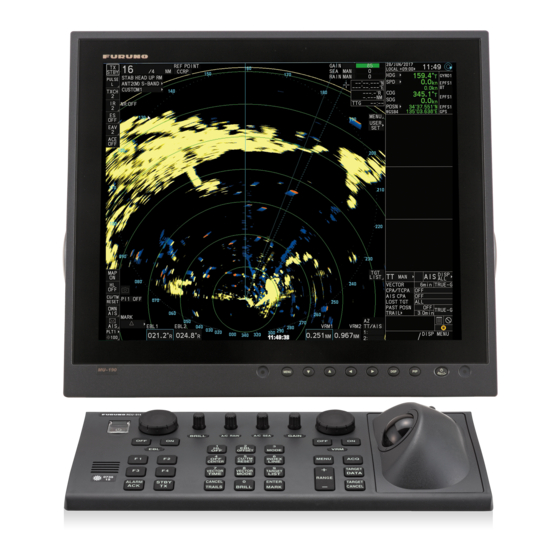
OPERATIONAL OVERVIEW Controls Overview Two types of control units are available for your FAR-2xx8: a full keyboard (RCU-014) or palm control (RCU-015/RCU-016). Most operations can be done with either type of Control Unit. Throughout the manual, procedures are outlined using the RCU-014, unless otherwise specified. 1.1.1 Control Unit RCU-014 You can control almost all aspects of your radar from the RCU-014. - Page 28 1. OPERATIONAL OVERVIEW Control Name Description 1, HL OFF key • With the menu open: Select menu item "1". • Press and hold to hide the heading line, range rings and OS symbol. Release to re-show the hidden items. See section 1.43.1.
- Page 29 1. OPERATIONAL OVERVIEW Control Name Description TARGET CANCEL key • Cancel tracking for the selected target. • Sleep the selected AIS target. • Long press: Cancel tracking for all TT targets. See section 3.2. Trackball controls See section 1.1.2. 1.1.2 Control Unit RCU-015/RCU-016 The RCU-015 and RCU-016 offer an easy to use mouse-like control interface, without the bulkiness of the RCU-014.
-
Page 30: How To Turn The Radar On/Off
How to Adjust the Brilliance The screen brilliance (brightness) for monitors can be adjusted as shown below. Note: The following procedure applies only to monitors supplied by FURUNO for this system. For other monitors, see the monitor operator’s manual to adjust the brilliance. -
Page 31: Display Indications
1. OPERATIONAL OVERVIEW Display Indications Note: The example screen below may differ slightly from your display, depending on the monitor purchased in your configuration. The overall information, however, is the same. The on-screen display for your radar system is divided into three main areas, as shown in the figure below. -
Page 32: Instantaccess Bar ™ Buttons
1. OPERATIONAL OVERVIEW ™ 1.4.1 InstantAccess bar buttons Button Description Upper Half Standby/Transmit button. Toggle between standby (STBY) and transmit (TX). Pulselength button. Selects the pulselength. Tune button. Toggles between automatic and manual tuning. (See section 1.17.1.) Note: For SSD antennas, this button appears as "TX CH x" (“x” denotes the channel used for transmission). -
Page 33: Radar Display And Shortcuts
1. OPERATIONAL OVERVIEW 1.4.2 Radar display and shortcuts Name Description Operational Display Area Radar echoes are displayed here. [RANGE] box Shows/changes the current range in use. [REF POINT] box Shows/changes the point of reference. Indications Shows indications for SART, shuttle ferry mode, etc. [WATCH] box •... - Page 34 1. OPERATIONAL OVERVIEW Name Description [TRIAL MANEUVERS] box • Activates/deactivates trial maneuvers. • Sets up trial maneuver parameters. [ACQUISITION ZONE] box • Adjust acquisition zone settings for target alarms. • Toggle between sentry zone and acquisition zone alert modes. [VRM] box •...
-
Page 35: Information And Settings
1. OPERATIONAL OVERVIEW 1.4.3 Information and settings Description Date/Time Shows date and time (with offset indication). Working indicator Stops rotating if the system is not functioning normally (screen freeze, etc.). Own Ship information Shows heading, speed, water tracking speed* , COG, SOG* , coordinates and sensor used for data input. -
Page 36: Menu Operations
1. OPERATIONAL OVERVIEW Menu Operations 1.5.1 How to open and close the main menu The main menu can be accessed from the control unit or from the on-screen box. The [MAIN MENU] appears in the information box at the right side of the screen. From the control unit (RCU-014) Press the MENU key on the control panel. - Page 37 1. OPERATIONAL OVERVIEW The next menu layer appears. Menu items with arrows, as shown in the above ex- ample figure, have their own menu layer. You can select these items to show the respective menu. 3. Roll the scrollwheel to select a menu item, then left-click. You can also select a menu item by pressing the corresponding numeric key.
-
Page 38: How To Use The On-Screen Box Menus
1. OPERATIONAL OVERVIEW How to Use the On-screen Box Menus Some radar functions can be accessed using the on-screen box as a shortcut to the respective menus. A “ ” at the right side of an on-screen box indicates that there is a menu shortcut available. -
Page 39: How To Use The Cursor Menu
1. OPERATIONAL OVERVIEW How to Use the CURSOR Menu Functions that require the use of the cursor, such as EBL offset and zoom, can be activated directly from the guidance box or from the [CURSOR] menu, either method with the cursor inside the operational display ar- ea. -
Page 40: Cursor Data
1. OPERATIONAL OVERVIEW Menu Item Description Page 2 TARGET DATA / ACQ SETTING Change target tracking settings. TARGET CANCEL SETTING Change target cancel settings. RANGE RINGS Show/hide the range rings. SLEEP ALL TARGETS Sleep all AIS targets. : Shown on A/B/W-types only : Shown on B/W-types only : Shown on A/B/W-types only when [5 AUTO TARGET TRACK], located in [2 MARKS] ([2 MARKS•CHARTS] for systems with Radar Plotter functionality) -
Page 41: How To Change The Cursor Data Attributes (B/W-Type Only)
1. OPERATIONAL OVERVIEW 1.8.1 How to change the cursor data attributes (B/W-type only) You can change the cursor bearing reference, cursor range unit, cursor size and also align the cursor by latitude/longitude. Changing some of these settings affects the in- dications in the cursor data display. - Page 42 1. OPERATIONAL OVERVIEW Function Available functions category ECHO CUSTOM SELECT, IR, ES, EAV, NOISE REJ, ANT SELECT, PULSE LENGTH, AUTO-SEA, AUTO-RAIN, TUNE SELECT, 2ND ECHO REJ, STC CURVE, STC RANGE, PM, SART, ECHO TRAIL, TRAIL T/R, WIPER* , ACE, ACE HIGH SENSITIVITY STD KEY ALERT ACK, STBY TX, HL OFF, EBL OFFSET, ORIENTATION- MODE, OFF CENTER, CU-TM RESET, PI LINE, VECTOR TIME,...
-
Page 43: How To Customize Operation
1. OPERATIONAL OVERVIEW 1.10 How to Customize Operation Several operation items can be customized to suit your needs. 1. Open the menu. 2. Select [9 INITIAL SETTING]. 3. Select [5 OPERATION]. The [OPERATION] menu appears. 4. Referring to the table below, press the menu item number to select the appropri- ate menu item to customize. - Page 44 1. OPERATIONAL OVERVIEW Menu items Description [9 USB MOUSE SPEED] Adjust the USB mouse sensitivity. A higher value in- crease the mouse cursor’s movement speed. Page 2 [2 AUTO COURSE UP RESET] Select [ON] to enable, or [OFF] to disable the auto- matic reset of the screen when using COURSE UP orientation and your course is more than 22.5°...
-
Page 45: How To Select The Interface For Heading Input
1. OPERATIONAL OVERVIEW 1.11 How to Select the Interface for Heading Input When a gyrocompass is connected, the ship’s heading appears on the right side of the screen, in the data display area. Heading input format can be selected as follows: 1. - Page 46 1. OPERATIONAL OVERVIEW Selection Explanation Stabilization Mode Log, speed over ground (SOG) Ground stabilization [LOG (BT)]* [LOG (WT)] Log, Speed Thru Water (STW) Sea stabilization [EPFS] Speed input by GPS navigator Ground stabilization [MANUAL] Manually input speed Sea stabilization [REF] Echo-referenced speed input Ground stabilization Speed input by ECDIS...
-
Page 47: Manual Speed Input
1. OPERATIONAL OVERVIEW 1.12.2 Manual speed input If the speed log is not working, enter speed manually as below. In this case the speed data type is shown as "MANUAL" and is speed thru water (STW). Manual speed input is not available on IMO-type radars when the AIS feature is active. 1. -
Page 48: How To Adjust The Date And Time
1. OPERATIONAL OVERVIEW Note 1: Where [2 POSITION SOURCE] is set to [DEAD RECKONING], the indi- cation "DR" appears at the bottom of the [OS POSN] box. Note 2: Where [2 POSITION SOURCE] is set to [DEAD RECKONING] or [MAN- UAL L/L INPUT], the AIS function cannot be used. -
Page 49: User Settings
1. OPERATIONAL OVERVIEW 5. Select [2 DATE-TIME], then select [UTC] or [LOCAL] as appropriate. • [UTC]: Date and time are displayed in UTC format. • [LOCAL]: Date and time are shown with the local time offset applied. If you selected [UTC], close the menu. If you selected [LOCAL], go to step 6. 6. - Page 50 1. OPERATIONAL OVERVIEW Function Setting(s) Menu/On-screen box VRM2 Display [ON] [VRM2] box Distance Maintained as per previous setting. EBL1 Display [ON] [EBL1] box Bearing Maintained as per previous setting. Reference [MAIN MENU] [3 NAV TOOLS] [3 EBL•VRM•CURSOR SET] EBL•CURSOR BEARING] EBL2 Display [ON]...
-
Page 51: How To Reset The User Settings
1. OPERATIONAL OVERVIEW 1.15.1 How to reset the user settings Menu operation 1. Open the menu. 2. Select [9 INITIAL SETTINGS]. 3. Select [4 USER SETTINGS]. You can also access this menu from the [USER SET] box, as shown to the right. 4. -
Page 52: How To Start/Stop Transmission
1. OPERATIONAL OVERVIEW 1.16 How to Start/Stop Transmission The radar is ready to transmit when the message "STBY" appears in the operational display area. Transmission can be started using one of the following procedures: • Using the control unit: Press the STBY TX key. ™... -
Page 53: How To Tune The Receiver (Magnetron Radars Only)
1. OPERATIONAL OVERVIEW 1.17 How to Tune the Receiver (Magnetron Radars Only) Your magnetron radar has a tuning function (automatic or manual). For solid-state ra- dars, tuning is not available. 1.17.1 How to select the tuning method Tuning of the magnetron is typically done at installation and is not normally required unless you have replaced the magnetron. -
Page 54: How To Select A Pulselength
1. OPERATIONAL OVERVIEW 1.18 How to Select a Pulselength ™ The pulselength in use is indicated on the PULSE button of the InstantAccess bar at the top-left of the screen.The table below shows the indications and their meaning. Appropriate pulselengths are preset to individual range scales and function keys. If you are not satisfied with the current pulselength settings, you can change them as shown in the procedure below. -
Page 55: How To Adjust Sensitivity
1. OPERATIONAL OVERVIEW 1.19 How to Adjust Sensitivity The gain control adjusts the sensitivity of the receiver. The proper setting is such that the background noise is just visible on the screen. If you set up for too little sensitivity, weak echoes may be missed. On the other hand excessive sensitivity yields too much background noise;... -
Page 56: How To Fine-Tune Sea Clutter Reduction
1. OPERATIONAL OVERVIEW 1.20.2 How to fine-tune sea clutter reduction Auto A/C SEA allows for fine tuning of the A/C SEA circuit, within ±20 dB. Accordingly, with the bar reading set to 50, gain is not lowered to minimum as with manual A/C SEA on close-in ranges. -
Page 57: How To Use The Berthing Stc Function
1. OPERATIONAL OVERVIEW How to reduce sea clutter manually from the on-screen box 1. Select [SEA MAN], following the procedure in section 1.20.1. 2. Place the cursor on the level indicator inside the A/C SEA box at the top of the display. -
Page 58: How To Select The Method Of Rain Clutter Reduction
1. OPERATIONAL OVERVIEW 1.21.1 How to select the method of rain clutter reduction 1. Place the cursor in the [RAIN AUTO] or [RAIN MAN] (whichever is shown) level indication at the top of the display. 2. Left-click to display [RAIN AUTO] or [RAIN MAN] as appropriate. Note: Unlike sea clutter reduction, rain clutter cannot be finely adjusted when set to [AUTO]. - Page 59 1. OPERATIONAL OVERVIEW How to interpret the graph Using the graph below as an example, a radar target originally detected on the 8 NM range can only be detected in rain at the ranges shown below: Accordingly, the short pulse may be preferable in rain on ranges less than 10 NM. 1-33...
-
Page 60: Interference Rejector
1. OPERATIONAL OVERVIEW 1.22 Interference Rejector Mutual radar interference can occur in the vicinity of an- other shipborne radar operating in the same frequency band. It is seen on the screen as a number of bright spikes either in irregular patterns or in the form of usu- ally curved spoke-like dotted lines extending from the center to the edge of the picture. -
Page 61: Echo Stretch
1. OPERATIONAL OVERVIEW 1.23 Echo Stretch The echo stretch feature enlarges targets in the range and bearing directions to make them easier to see, and it is available on any range. There are three types of echo stretch, 1, 2 and 3, and the higher the number the greater the amount of stretch. Note: The echo stretch magnifies not only small target pips but also returns (clutter) from sea surface, rain and radar interference. -
Page 62: Echo Averaging
1. OPERATIONAL OVERVIEW 1.24 Echo Averaging The echo averaging feature effectively reduces sea clutter. Echoes received from sta- ble targets such as ships appear on the screen at almost the same position every ro- tation of the antenna. On the other hand, unstable echoes such as sea clutter appear at random positions. - Page 63 1. OPERATIONAL OVERVIEW How to use the echo average function from the menu 1. Open the menu. 2. Select [1 ECHO]. 3. Select [2 CUSTOMIZED ECHO]. Note: You can also right-click the [PICTURE] box to access this menu. 4. Select [4 ECHO AVERAGE]. 5.
-
Page 64: Automatic Clutter Elimination (Ace) Function
1. OPERATIONAL OVERVIEW 1.25 Automatic Clutter Elimination (ACE) Function This radar has the Automatic Clutter Elimination (ACE) function. This function detects sea and rain clutter from received echoes’ and automatically reduces sea and rain clutter according to the Automatic Clutter Elimination (ACE) threshold setting. Note: Use this function with caution. -
Page 65: How To Get High Sensitivity
1. OPERATIONAL OVERVIEW 1.25.3 How to get high sensitivity When the ACE function is [ON], the high sensitivity mode is also available. This re- quires a function key to be assigned with the [ACE HIGH SENSITIVITY] function (see section 1.9). To use high sensitivity mode, activate the ACE feature, then press the assigned func- tion key. -
Page 66: Noise Rejector
1. OPERATIONAL OVERVIEW 1.26 Noise Rejector White noise can show itself on the screen as random “speckles” spread over the entire radar image. This equipment reduces the white noise, then improves the on-screen S/ N ratio by processing the weighted moving average filter for the received echoes in the range direction. -
Page 67: How To Preset Controls For A Specific Navigation Purpose
1. OPERATIONAL OVERVIEW 1.28 How to Preset Controls for a Specific Navigation Purpose Every time your navigating environment or task changes, you must adjust the radar, which can be a nuisance in a busy situation. Instead of changing radar settings case by case, it is possible to assign the function keys to provide optimum settings for often- encountered situations. - Page 68 1. OPERATIONAL OVERVIEW Default settings AUTO AUTO TARGET HATCHING* RAIN ANALYZER* CUSTOM1 MAN-30 MAN-0 CUSTOM2 AUTO-30 MAN-0 CUSTOM3 MAN-30 MAN-0 NEAR MAN-30 MAN-0 AUTO-40 MAN-0 NEAR BOUY MAN-30 MAN-0 FAR BUOY AUTO-30 MAN-0 ROUGH SEA MAN-50 MAN-40 SHIP MAN-30 MAN-0 HARBOR MAN-30 MAN-0...
- Page 69 1. OPERATIONAL OVERVIEW Default settings for [PULSELENGTH] 0.125 NM 0.75 NM 1 NM* 1.5 NM 2 NM* 3 NM to 0.5 NM CUSTOM1 CUSTOM2 CUSTOM3 NEAR NEAR BOUY FAR BUOY ROUGH SEA SHIP HARBOR BIRD COAST 4 NM* 6 NM 8 NM* 12 NM 16 NM*...
-
Page 70: How To Select A Customized Echo
1. OPERATIONAL OVERVIEW 1.28.1 How to select a customized echo Left-click the [CUSTOMIZE ECHO] box at the top left of the screen to cycle through the options and select a customized echo option. The available options depend on the settings selected for [3 SELECT CUSTOM] in the [ECHO] menu. -
Page 71: How To Restore A User Customized Echo To The Saved Settings
1. OPERATIONAL OVERVIEW 1 to 4: Control dynamic range. 1 provides the widest dynamic range; 4 is the nar- rowest dynamic range. A: Low level echo brilliance is reduced and noise and clutter are also reduced. B: Low and high level echoes are displayed evenly. C: High level echoes' outer edge has gradation to indicate the echo level, with the higher level echo at the core. -
Page 72: How To Restore A User Customized Echo To The Factory Default Settings
1. OPERATIONAL OVERVIEW 1.28.4 How to restore a user customized echo to the factory default settings You can restore customized echo options to their factory default settings (see the ta- bles on page 1-42 for a list of the default settings). 1. -
Page 73: How To Reject Second-Trace Echoes
1. OPERATIONAL OVERVIEW 1.29 How to Reject Second-trace Echoes In certain situations, echoes from very distance targets can appear as false echoes (second-trace echoes) on the screen. This occurs when the return echo is received one transmission cycle later, or after a next radar pulse has been transmitted. This equipment lengthens the pulse repetition period to reject false echoes. -
Page 74: Orientation Modes
1. OPERATIONAL OVERVIEW 1.30 Orientation Modes This radar has the following orientation modes available: Mode Description Relative Motion (RM) modes [HEAD UP RM] Not stabilized [STERN UP RM]* The radar image is rotated 180°. Graphics and relative and true bearings are also rotated 180°. [STAB HEAD UP RM] Head-up with compass bearing scale (True Bearing) where the bearing scale rotates with the compass reading. - Page 75 1. OPERATIONAL OVERVIEW COURSE UP mode The radar picture is stabilized and displayed with the currently selected course at the top of the screen. When you change the heading, the heading line moves with the course selected. If you select a new course, select the course up mode again to display the new course at the top of the display.
-
Page 76: How To Select A Range Scale
1. OPERATIONAL OVERVIEW Note: The position of the own ship marker and bearing scale change according to ref- erence position and off-centering. • [ANT]: When OFF CENTER is active, the bearing scale intervals change according- • [CCRP]: When the CCRP moves outside the operational display area, the bearing scale intervals may not be displayed correctly. -
Page 77: How To Measure Range
1. OPERATIONAL OVERVIEW 1.32 How to Measure Range The range to a target can be measured three ways: with the fixed range rings, with the cursor, or with the VRM. Use the fixed range rings to get an estimate of the range to a target. The rings are the concentric solid circles on the display. -
Page 78: How To Measure Range With The Variable Range Marker (Vrm)
1. OPERATIONAL OVERVIEW 1.32.2 How to measure range with the variable range marker (VRM) There are two VRMs, No. 1 and No. 2, which appear as dashed rings so that you can distinguish them from the fixed range rings. The two VRMs can be distinguished from each other by the different lengths of their dashes;... -
Page 79: How To Set The Vrm Unit Of Measurement (B-Type Only)
1. OPERATIONAL OVERVIEW On-screen menu box operation 1. Select the appropriate [VRM] box. 2. The guidance box reads "VRM ON/". Left-click to turn on the VRM. The guidance box now reads "VRM SET L = DELETE /". Further, the box is highlighted and the corresponding VRM appears. 3. -
Page 80: How To Measure Bearing
1. OPERATIONAL OVERVIEW 1.33 How to Measure Bearing The Electronic Bearing Lines (EBLs) are used to take bearings of targets.There are two EBLs, EBL1 and EBL2. Each EBL is a straight dashed line extending out from the own ship position up to the circumference of the radar picture. The two EBLs can be distinguished from each other by the different lengths of their dashes;... -
Page 81: True Or Relative Bearing
1. OPERATIONAL OVERVIEW On-screen menu box operation 1. Select the appropriate EBL box. 2. The guidance box reads "EBL ON/". Press the left button to turn on the EBL.The guidance box now reads "EBL SET L=DELETE /". 3. Press the left button again and the cursor jumps to inside the operational display area. -
Page 82: Collision Assessment By Offset Ebl
1. OPERATIONAL OVERVIEW 1.34 Collision Assessment by Offset EBL The origin of the EBL can be placed anywhere to enable measurement of range and bearing between any two targets. This function is also useful for assessment of the potential risk of collision. It is possible to read CPA (Closest Point of Approach) by us- ing the EBL range marker as shown in (a) in the illustration below. -
Page 83: How To Set The Origin Point Reference For Ebl Offset
1. OPERATIONAL OVERVIEW Using the [CURSOR] menu (on-screen box) 1. Select the operational display area, then right-click. The [CURSOR] context menu appears. 2. Select [EBL OFFSET]. 3. Select the operational display area, then left-click. The EBL line is attached to the cursor. -
Page 84: How To Measure Range And Bearing Between Two Targets
1. OPERATIONAL OVERVIEW 1.35 How to Measure Range and Bearing Between Two Targets How to measure range and bearing from the [CURSOR] menu This procedure uses EBL1 and VRM1 as an example and is written on the premise that neither of the EBLs or VRMs is active. 1. - Page 85 1. OPERATIONAL OVERVIEW How to measure range and bearing from the control unit (RCU-014) Range and bearing can be measure using the EBL OFFSET key. 1. Press the EBL ON key to activate EBL1. 2. Place the cursor inside the operational display area, then press the EBL OFFSET key.
-
Page 86: How To Off-Center The Display
1. OPERATIONAL OVERVIEW 1.36 How to Off-Center the Display Own ship position, or sweep origin, can be displaced to expand the view field without switching to a larger range scale. The sweep origin can be off-centered to the cursor position, but not more than 75% of the range in use; if the cursor is set beyond 75% of the range scale, the sweep origin will be off-centered to the point of 75% of the limit. -
Page 87: Target Trails
1. OPERATIONAL OVERVIEW 1.37 Target Trails The trails of the radar echoes of targets can be displayed in the form of synthetic af- terglow. Target trails are shown either relative or true and can be sea or ground stabi- lized. True motion trails require a compass signal, and position and speed data. When the range is changed, trails are continued for targets which were already displayed in the previous range. -
Page 88: Trail Time
1. OPERATIONAL OVERVIEW 5. Select [2 TRAIL MODE]. 6. Select the appropriate trail mode. • [REL]: Relative target trails. Targets move relative to own ship and stationary targets appear smeared. • [TRUE]: True target trails. Targets true movements are shown, stationary tar- gets are not smeared. -
Page 89: Trail Gradation
1. OPERATIONAL OVERVIEW [TRAIL LENGTH] Available options setting [NORMAL] [OFF], [15 sec], [30 sec], [1 min] to [30 min] at 30-seconds inter- vals, [CONT]. [12H] [OFF], [00:30] to [12:00] at 30 minute intervals, [CONT]. [24H] [OFF], [00:30] to [24:00] at one hour intervals, [CONT]. [48H] [OFF], [00:30] to [48:00] at two hour intervals, [CONT]. -
Page 90: Narrow Trails (B/W-Type Only)
1. OPERATIONAL OVERVIEW 1.37.5 Narrow trails (B/W-type only) Target trails can be painted with thinner lines if desired. This csection 1.37.2an be useful when there are a lot of targets on the screen and it is hard to distinguish one from another. -
Page 91: How To Erase/Restart Trails
1. OPERATIONAL OVERVIEW 1.37.8 How to erase/restart trails All trails can be erased (including those in the memory) and restarted to start fresh trails. There are three methods you can use to erase trails. To erase all trails displayed in the operational display area: •... -
Page 92: 10How To Show/Hide Os Trails
1. OPERATIONAL OVERVIEW 1.37.10 How to show/hide OS trails To show or hide the OS trail at any time, follow the procedure below. 1. Open the menu. 2. Select [1 ECHO]. 3. Select [0 NEXT]. 4. Select [4 TRAILS]. The [TRAILS] menu appears. Note: You can also right-click the [TRAIL] box to access this menu. -
Page 93: 12How To Set The Trail Length (B/W-Type Only)
1. OPERATIONAL OVERVIEW 1.37.12 How to set the trail length (B/W-type only) You can save up to 48 hours of trails. the [TRAIL LENGTH] can be set to one of the following lengths: [NORMAL], [12H], [24H] or [48H]. To set the trail length, follow the procedure below. -
Page 94: 14How To Remove The Colors From A Section Of A Multicolor Trail (B/W-Type Only)
1. OPERATIONAL OVERVIEW When [TRAIL LENGTH] is set to other than [NORMAL] When [4 TRAIL LENGTH] is set to [12H], [24H] or [48H], you can select the color for each trail segment. 1. Open the menu. 2. Select [1 ECHO]. 3. -
Page 95: 15How To Offset The Colors For Multicolored Trail (B/W-Type Only)
1. OPERATIONAL OVERVIEW 1.37.15 How to offset the colors for multicolored trail (B/W-type only) You can “shift” the order of the trail colors. When this function is active, the first color used to paint the trail is changed. Note: If the trail time set at the [TRAIL] box is longer than the time selected at [4 TRAIL LENGTH] in the [TRAIL] menu, trails are not displayed after the trail time elapses. -
Page 96: Target Analyzer (B/W-Type Only)
1. OPERATIONAL OVERVIEW 1.38 Target Analyzer (B/W-type only) The target analyzer function analyzes echoes and assists the operator to determine dangerous targets. This function is particularly useful under heavy rain/snow or where there is surface reflection, which can cause interference and noise. The target analyzer function can also place hatching over heavy rain areas, reducing the visible interference and allowing a clearer view of potential targets. -
Page 97: How To Activate/Deactivate The Target Analyzer
1. OPERATIONAL OVERVIEW Note 1: This function works best when the settings for [GAIN], [STC], [RAIN], [NOISE REJECT] and [VIDEO CONTRAST] are properly adjusted (surface reflections are dis- played in green and rain is displayed in gray). Note 2: This function recognizes moving targets as approaching targets. Buoys and other stationary objects are not recognized as approaching targets by this function. -
Page 98: Target Alarm
1. OPERATIONAL OVERVIEW 1.39 Target Alarm The target alarm serves to alert the navigator to targets (ships, landmasses, etc.) en- tering a specific area, with audiovisual alerts. The operator can set the alarm zones at any location, with any size, however, the zones must be inside the operational display area. -
Page 99: How To Mute The Target Alarm
1. OPERATIONAL OVERVIEW 1.39.2 How to mute the target alarm A target in the target alarm zone produces both visual (flashing) and audible (beep) alarms. To silence the audio alarm select the appropriate target alarm box then left- click. The target alarm box indication shows "MUTE". This will deactivate the audio alarm but will not stop the flashing of the offending target. -
Page 100: Pi (Parallel Index) Lines
1. OPERATIONAL OVERVIEW 1.40 PI (Parallel Index) Lines PI lines are useful for keeping a constant distance be- tween own ship and a coastline or a partner ship when navigating. You can control the presentation and interval of the PI lines from the [PI Line] box, which is at the lower-left corner of the screen. -
Page 101: How To Change Pi Line Bearing And Interval
1. OPERATIONAL OVERVIEW W-types 1. Open the menu. 2. Select [3 NAV TOOLS]. 3. Select [2 PI LINES]. The [PI LINES] menu ap- pears. 4. Select [2 SET MAXIMUM PI 1•3 LINES] or [3 SET MAXIMUM PI 2•4 LINES] as required. Up to four sets of PI lines are available depend- ing on the maximum number of PI lines selected on the menu. -
Page 102: How To Change The Pi Line Orientation
1. OPERATIONAL OVERVIEW 1.40.5 How to change the PI line orientation PI lines orientation can be selected from parallel or perpendicular. Note: This function is only available when [SET MAXIMUM PI LINES] is set for other than [1]. 1. Open the menu. 2. -
Page 103: How To Use The Net (Diamond) Cursor (B/W-Type Only)
1. OPERATIONAL OVERVIEW 10. Spin the scrollwheel to adjust the front PI line length. The available range is 0.000 NM to 24.000 NM. All PI lines beyond this mark will be hidden. 11. To change the length of other PI lines, activate the line you wish to adjust, then repeat steps 1 through 10. -
Page 104: How To Set The Net Cursor Dimensions And Orientation
1. OPERATIONAL OVERVIEW 1.41.2 How to set the net cursor dimensions and orientation 1. Open the menu. 2. Select [3 NAV TOOLS]. 3. Select [3 EBL•VRM•CURSOR SET]. 4. Select [0 NEXT] to show the second page of the menu. [3 FRONT HALF LENGTH]. 6. -
Page 105: Zoom
1. OPERATIONAL OVERVIEW 1.42 Zoom The zoom function enlarges an area of interest as large as twice the normal viewing size, in the [INFORMATION BOX]. Zoom can be selected using the control unit or from a preset function key (see section 1.9 for how to assign functions to the function keys). Zoom is not available when the [INFORMATION BOX] setting for [TARGET DATA] is [LARGE]. -
Page 106: How To Use Marks
1. OPERATIONAL OVERVIEW 1.43 How to Use Marks 1.43.1 Heading line mark The heading line is a line from the own ship position to the outer edge of the radar dis- play area and appears at zero degrees on the bearing scale in HEAD UP mode. The orientation of the line changes depending on the ship orientation in NORTH UP and True Motion modes. -
Page 107: North Mark
1. OPERATIONAL OVERVIEW 1.43.3 North mark The north mark is displayed as a short dotted line on the in- side edge of the operational display area. In HEAD UP mode, the north mark moves according to the own ship bearing. The north mark is hidden when the radar is in standby mode. -
Page 108: Antenna Mark
1. OPERATIONAL OVERVIEW 7. Select [4 BARGE ARRANGEMENT]. This item lets you set a single barge or a barge chain. Spin the scrollwheel to select a value, then left click to move the cur- sor to the next line. Select number of barges (max. 9) to display. As you spin the scrollwheel the squares light or extinguish and the number of barges selected ap- pears at the right side. -
Page 109: Drop Mark
1. OPERATIONAL OVERVIEW 1.44 Drop Mark The operator can inscribe a drop mark at a selected lo- cation to find the range and bearing from own ship to the mark. This can be useful for marking a point to avoid while navigating to a destination. 1.44.1 How to activate the drop mark To active the drop mark feature, do the following:... -
Page 110: Brilliance And Color Schemes
1. OPERATIONAL OVERVIEW 1.45 Brilliance and Color Schemes Brilliance and color schemes are preset “palettes” that let you change the brilliance and color of on-screen data together. 1.45.1 How to select a brilliance and color scheme The system has four presets of brilliance and color settings to choose from. Each pre- set is customizable (see section 1.45.3). - Page 111 1. OPERATIONAL OVERVIEW 5. Select the appropriate item to adjust. Menu item Description Page 1 [2 ECHO COLOR] Changes the color used to display echoes. The avail- able colors are: [YEL] (yellow), [GRN] (green), [WHT] (white), [AMB]* (amber), [M-GRN]* (mutli-green), [M- CYA]* (multi-cyan).
-
Page 112: How To Change The Color Palette
1. OPERATIONAL OVERVIEW 1.45.3 How to change the color palette This radar provides eight sets of color and brilliance schemes to match any ambient lighting condition and can be assigned to a [BRILL] box preset. 1. Open the menu. 2. Select [9 INITIAL SETTINGS]. 3. -
Page 113: How To Display And Set Up Navigational Data
1. OPERATIONAL OVERVIEW 1.46 How to Display and Set Up Navigational Data Wind, depth, ocean current, wave data, water temperature, date and time and way- point data can be displayed on this radar, however appropriate sensors are required. 1.46.1 How to set up the navigational data 1. -
Page 114: How To Display Navigational Data
1. OPERATIONAL OVERVIEW Note 2: [4 WAVE DATA] can only be active at one radar at any time. If [4 WAVE DATA] is turned [ON] at another radar in the same network, it is automatically turned [OFF] at this radar. 5. -
Page 115: How To Use The Information Box
1. OPERATIONAL OVERVIEW 1.47 How to Use the Information Box The information box shows target data, navigational data and zoomed areas of the ra- dar display. To set up the information box, do the following: 1. Open the menu. 2. Select [7 INFORMATION BOX]. 3. - Page 116 1. OPERATIONAL OVERVIEW 1-90...
-
Page 117: Interswitch
1. OPERATIONAL OVERVIEW 1.48 Interswitch The interswitch of this radar uses an Ethernet to transfer video and control signals. A digital signal transfers the video and control signals. You can connect up to four an- tennas and four display units. Set radar display and antenna groups from the [ANTEN- NA SELECT] display. -
Page 118: How To Preset Antenna And Display Combinations
1. OPERATIONAL OVERVIEW 1.48.2 How to preset antenna and display combinations You can preset the antenna and display combinations for each antenna and display in the radar system. As an example, the procedure below shows how to select the no. 1 antenna unit for the no. - Page 119 1. OPERATIONAL OVERVIEW • Radar functions are controlled independently, dependently or commonly depending on selection as [MASTER] or [SLAVE] (see the following table). Radar Functions Control Master Display Option Slave Display Option AIS function Independent Desired value can be set Desired value can be Brilliance Echo trails Lat/long data...
-
Page 120: How To Clear The Interswitch
1. OPERATIONAL OVERVIEW Compatibility of display and operation When connecting with FAR-2xx7 series radar When switching the antenna from FAR-2xx8 to FAR-2xx7, the image for FAR-2xx7 is displayed on the screen and each function is operative. However, when switching the antenna from FAR-2xx7 to FAR-2xx8, the following functions are not operative. - Page 121 1. OPERATIONAL OVERVIEW Note: If the blind sector and the direction of the PM antenna overlap one another, turn off the blind sector in order to display echoes correctly. The radar is automatically set as follows when the performance monitor is activated. Adjustable Setting at PM Setting...
-
Page 122: How To Check The Radar’S Performance
1. OPERATIONAL OVERVIEW 1.49.2 How to check the radar’s performance The range scale is automatically set to 24 NM. The radar screen will show arcs. If the radar transmitter and receiver are in good working conditions in as much as the origi- nal state when the monitor was turned on, the innermost arcs should appear between 8.0 NM to 19.8 NM. -
Page 123: How To Change The Reference Position
1. OPERATIONAL OVERVIEW 1.50 How to Change the Reference Position The reference position for measurements (range, bearing, etc.) and markers (heading line, stern mark, etc.) can be the radar antenna position ([ANT]) or the consistent com- mon reference point ([CCRP]). The reference position is a location on own ship to which all horizontal measurements, for example range, bearing, relative course, relative speed, closest point of approach (CPA) or time to closest point of approach (TCPA), are normally referenced. -
Page 124: Anchor Watch
1. OPERATIONAL OVERVIEW Reference point Category Item CCRP Table continued from previous page CPA, TCPA Calculated with an- Calculated with tenna position at CCRP at center. center. BCR, BCT Calculated from bow position. Own ship data Heading Data is taken from respective sensors, re- gardless of reference point selected. -
Page 125: Alerts
1. OPERATIONAL OVERVIEW 1.52 Alerts 1.52.1 What is an alert? “Alert” is a generic name for a notice to any unusual or potentially dangerous situation generated within the system. For detailed information regarding specific alerts and alert codes, including possible remedies, see "ALERT LIST"... -
Page 126: How To Interpret The [Alert] Box
1. OPERATIONAL OVERVIEW 1.52.2 How to interpret the [ALERT] box When an alert condition is found, the applicable alert message appears in the [ALERT] box. A buzzer sounds for alarm and warning alerts. When no active alert and indica- tion occurs, "NO ACTIVE ALERTS" appears in the [ALERT] box. The [ALERT] box is composed of three lines of text information, and several icons, as shown below. -
Page 127: Alert List
1. OPERATIONAL OVERVIEW 1.52.5 Alert list The alert list displays the names of violated alerts, including the time and date violated. Up to 100 alerts are stored in the internal memory. Unacknowledged alarms are dis- played first in the list (in red text), in the order in which they appear in the [ALERT] box. Unacknowledged warnings are displayed in the list (in yellow-orange text), in the order in which they appear in the [ALERT] box. - Page 128 1. OPERATIONAL OVERVIEW Detailed alert information To view detailed information for an alert, open the alert list, place the cursor on the alert you want to view detailed information for, then press and hold the left button. 1-102...
-
Page 129: Alert Icons And Their Meanings
1. OPERATIONAL OVERVIEW 1.52.6 Alert icons and their meanings 1-103... -
Page 130: Responsibility Transfer Alert
1. OPERATIONAL OVERVIEW 1.52.7 Responsibility transfer alert MSC302(87) requires the use of the “responsibility transfer alert” which functions in the multiple sensor, multiple equipment installation. When one sensor or one equip- ment fails but does not disturb the system operation (other sensor or equipment is nor- mal), the AMS automatically sends the “responsibility transfer alert”... -
Page 131: Icing Prevention
1. OPERATIONAL OVERVIEW 1.53 Icing Prevention You can rotate the antenna (24 rpm) without transmission to keep the antenna from freezing. 1. Open the menu. 2. Select [9 INITIAL SETTINGS]. 3. Select [5 OPERATION]. 4. Select [7 ICING PREVENTION]. 5. Select [ON] or [OFF] as appropriate. If you select [ON], the message "Rotate An- tenna to Prevent Icing."... -
Page 132: How To Select A Display Mode (B/W-Type Only)
1. OPERATIONAL OVERVIEW 1.54 How to Select a Display Mode (B/W-type Only) B/W-type radars of this series have three echo display modes available: • [CIRCLE] mode: The echoes are displayed inside a circle on the screen. This is the default (IMO compliant) mode. •... -
Page 133: How To Manage Sd Card Data
The table below lists the SD cards that have been verified as compatible for use with this equipment. Note 1: The cards were verified using basic functions. All functions were not verified. FURUNO does not guarantee card operations. Note 2: SD cards other than those listed below have not been verified. Maker... -
Page 134: How To Insert Sd Cards
1. OPERATIONAL OVERVIEW 1.55.4 How to insert SD cards The SD card slot is located on the front face of the processor unit, between the LAN1 port and the DVI-I port. Note: Do not use any instruments to insert the card. 1. -
Page 135: How To Save Data To An Sd Card
1. OPERATIONAL OVERVIEW 1.55.6 How to save data to an SD card 1. Open the menu. 2. Select [6 FILES]. The [FILES] menu appears. 3. Select [2 SAVE DATA]. 4. Select the data to save. The software keyboard appears. 5. Using the software keyboard, name the file, then select [END] to start saving data. -
Page 136: How To Take A Screenshot
1. OPERATIONAL OVERVIEW 1.56 How to Take a Screenshot The system has an in-built screenshot feature. To use the feature, a SD Card must be inserted in the Processor Unit. If there is no card inserted, the screenshot button on the screen is not active. -
Page 137: Dual Radar (A/B-Types Only)
1. OPERATIONAL OVERVIEW 1.58 Dual Radar (A/B-types only) When installing two FAR-2xx8 series radars, the image from both radars (main radar and external radar) may be shown together on one radar display. This allows you to take advantage of the best characteristics each type of radar has to offer. The dual radar function is available only for A/B-types. -
Page 138: How To Toggle Control Of Each Dual Radar Display
1. OPERATIONAL OVERVIEW 1.58.1 How to toggle control of each dual radar display Note: Dual radar mode must be enabled and both radars must be turned on. You can switch between radars to control either your own, or the external radar from the antenna box. -
Page 139: Operating Considerations For The Dual Radar Display
1. OPERATIONAL OVERVIEW Radar Functions Control Master Slave Dependent Desired value can Cannot control Control be set Tuning TT LOST warning Common Item Commonly Item Commonly Controlled Control Controlled TT alerts ACK TT acquire *: When the connected radar antenna is a magnetron-type, and the radar is assigned as “Slave”, the desired value can be set for these functions. - Page 140 1. OPERATIONAL OVERVIEW Notes regarding dual radar operations • The dual radar function is available between two FAR-2xx8 series radars using the LAN. FAR-2xx7 and FAR-3xx0 series radars are not compatible. • When a transmission error occurs between two radars in the dual radar mode, the Alert "LOST ISW FUNC"...
-
Page 141: Wave Mode
1. OPERATIONAL OVERVIEW 1.59 Wave Mode You can output echo data from this radar to a PC with the wave analysis software in- stalled. The wave analysis software calculates incoming waves and gives you an on- screen indication as to wave size, direction and time between waves. This section covers how to use the wave mode and related functions on your FAR- 2xx8 series radar. -
Page 142: Doppler Feature (X-Band Solid State Radars Only)
Doppler Feature (X-band Solid State Radars only) When activated, the doppler feature can help with clutter reduction, making targets easier to find. This feature is only available with FAR-2228-NXT, FAR-2228-NXT-BB or FAR-2328-NXT. To activate and use the feature, follow the procedure below. -
Page 143: Radar Observation
RADAR OBSERVATION General 2.1.1 Minimum range The minimum range is defined by the shortest distance at which, using a scale of 1.5 or 0.75 nm, a target having an echoing area of 10 m is still shown separate from the point representing the antenna position. -
Page 144: X-Band And S-Band
This is determined by pulselength only. Practically, a 0.08 microsecond pulse offers the discrimination better than 40 m as do so with all FURUNO radars. Test targets for determining the range and bearing resolution are radar reflectors... -
Page 145: Bearing Accuracy
2. RADAR OBSERVATION 2.1.5 Bearing accuracy One of the most important features of the radar is how accurately the bearing of a tar- get can be measured. The accuracy of bearing measurement basically depends on the narrowness of the radar beam. However, the bearing is usually taken relative to the ship’s heading, and thus, proper adjustment of the heading line at installation is an important factor in ensuring bearing accuracy. - Page 146 2. RADAR OBSERVATION Sidelobe echoes Every time the radar pulse is transmitted, some radiation escapes on each side of the beam, called “sidelobes”. If a target exists where it can be detected by the side lobes as well as the main lobe, the side echoes may be represented on both sides of the true echo at the same range.
-
Page 147: Sart (Search And Rescue Transponder)
2. RADAR OBSERVATION Shadow sectors Funnels, stacks, masts, or derricks in the path of the antenna block the radar beam. If the angle subtended at the antenna is more than a few degrees, a non-detecting sec- tor may be produced. Within this sector targets can not be detected. SART (Search and Rescue Transponder) 2.3.1 SART description... -
Page 148: How To Show Sart Marks On The Radar Display
2. RADAR OBSERVATION 2.3.2 How to show SART marks on the radar display This radar is equipped with a feature that optimally sets up the radar for SART detec- tion. This feature automatically detunes the radar receiver out of its best tuning condi- tion. -
Page 149: Racon
2. RADAR OBSERVATION Radar bandwidth This is normally matched to the radar pulselength and is usually switched with the range scale and the associated pulselength. Narrow bandwidths of 3-5 MHz are used with long pulses on long range scales and wide bandwidths of 10-25 MHz with short pulses on short ranges. -
Page 150: Solid State Radar
2. RADAR OBSERVATION Solid state radar In Solid State radars, long-range and short-range pictures are mixed before they are displayed on the screen. Due to this mixing process, echoes may be displayed differ- ently when compared with magnetron radars. Range and signal intensity At long-range, even though the Solid State radar has lower transmission power than magnetron radars, the signal intensity is equivalent. -
Page 151: Target Tracking (Tt)
TARGET TRACKING (TT) Precautions when Using Target Tracking... -
Page 152: Tt Controls
3. TARGET TRACKING (TT) TT Controls The control unit has three keys that are used in the target tracking mode. The keys are indicated in the figure below. • ACQ: Acquires the selected echo as a target. • TARGET DATA: Shows the selected target’s data in the information box. •... -
Page 153: How To Select The Tt Mode
3. TARGET TRACKING (TT) How to Select the TT mode You can click the TT acquisition mode indication in the TT•AIS box to select the re- quired mode. The indication changes depending on the setting for [TT SELECT] in the [TT] menu. TT mode selected Indication change [MANUAL 100]... -
Page 154: How To Acquire And Track Targets
3. TARGET TRACKING (TT) 4. Select [2 TT SELECT], then select the acquisition condition. Your selection here changes how many targets can be acquired, both automati- cally and manually. Menu setting Acquisition condition [MANUAL 100] 100 targets manually, auto acquisition not available [MANUAL 75 •... -
Page 155: How To Enter Own Ship Speed
3. TARGET TRACKING (TT) Note 1: For successful acquisition, the target should be within 24 NM (or 32 NM, de- pending on initial setting) from own ship and not obscured by sea or rain clutter. Note 2: You are alerted when the capacity of manual acquisition is 95% and 100%. These alerts are "TT TGT 95%(MAN)"... - Page 156 3. TARGET TRACKING (TT) 4. Repeat step 3 until to place up to three reference points. 5. Right-click to deactivate the reference mark function. 6. Right-click the [SPD] indication at the top-right of the screen to show the [SPEED] menu. 7.
-
Page 157: How To Cancel Target Tracking
3. TARGET TRACKING (TT) How to Cancel Target Tracking When the number of tracked targets reaches maximum capacity, the alert box shows "TT TGT FULL(MAN)" or "TT TGT FULL(AUTO)", based on the selected TT mode. No new targets can be acquired until a tracked target is lost or tracking is canceled. When this occurs, cancel tracking for non-dangerous targets as required. -
Page 158: Tt Lost Alert
3. TARGET TRACKING (TT) TT Lost Alert Targets not detected in nine consecutive scans become “lost targets”. A lost target is shown in the display with a flashing red " ". Flashing stops after the lost alert is ac- knowledged. Further, the alert box shows the "TT TARGET LOST" alert in orange characters and the audible alert sounds. -
Page 159: Tt Symbols And Attributes
3. TARGET TRACKING (TT) TT Symbols and Attributes The TT symbols used in this equipment are compliant with IEC62288. For details re- garding the symbols and their meanings, see "TT symbols" on page AP-43. 3.9.1 How to adjust symbol brilliance Note: Each color scheme (palettes PLT1 to PL4) can be adjusted individually. -
Page 160: How To Display/Remove Target Data
3. TARGET TRACKING (TT) 3.9.3 How to select a TT symbol (B/W-types only) In addition to the "standard" circle TT symbol, you may select from the symbols shown below, using the full keyboard. This cannot be done with trackball-type control unit (RCU-015, RCU-016). -
Page 161: How To Show/Remove Target Data In The Data Display Area
3. TARGET TRACKING (TT) 3.10.2 How to show/remove target data in the data display area Place the cursor on a desired tracked target and left-click, or press the ACQ key. The target’s symbol is surround with a broken square and the selected TT target’s data is shown in the data display area. -
Page 162: How To Display, Hide And Sort The Target List
3. TARGET TRACKING (TT) 3.10.3 How to display, hide and sort the target list The target list provides a comprehensive data display of all TT (and AIS) targets being tracked. A total of 1303 targets can be displayed in the list. How to display the target list Select the [TGT LIST] menu item at the bottom-right of the screen, then left-click. - Page 163 3. TARGET TRACKING (TT) How to sort the target list 1. With the target list displayed, place the cursor on the sorting method indication to the right of [SORT] ("CPA" in the example below). The indication is highlighted. 2. Spin the scrollwheel to select the sort method, referring to the table below, then left-click.
-
Page 164: How To Assign A Preset Name To Tt Targets (B/W-Type Only)
3. TARGET TRACKING (TT) 3.11 How to Assign a Preset Name to TT Targets (B/ W-type only) You can assign a preset name to TT targets, which is displayed alongside the TT num- ber in the target list. 3.11.1 How to activate the preset name function 1. -
Page 165: How To Assign A Name To A Tt
3. TARGET TRACKING (TT) 3.11.3 How to assign a name to a TT 1. Referring to section 3.11.1, activate the preset name function. 2. Referring to section 3.10.2, show the target’s data in the data display area. 3. Place the cursor on the target data, then press the left button. The [TARGET NAME] menu appears. -
Page 166: Vector Modes
3. TARGET TRACKING (TT) 3.12 Vector Modes Target vectors can be displayed relative to own ship’s heading (Relative) or North (True). Note: IMO recommends the use of true vector mode in sea stabilization or relative vector mode for collision avoidance. 3.12.1 Description of vectors Stabilization modes... - Page 167 3. TARGET TRACKING (TT) Ground stabilization and sea stabilization Target vectors can be ground stabilized or sea stabilized in the True Motion mode. To select speed over the ground or speed through the water data, click the stabilization mode button at the top-left of the screen or open the page from the menu. Select for ground stabilization or for sea stabilization.
-
Page 168: Vector Mode And Length
3. TARGET TRACKING (TT) 3.12.2 Vector mode and length Vectors can be displayed in true or relative modes. Vector lengths can be set between 30 seconds and 60 minutes. The vector tip shows an estimated position of the target after the selected vector time elapses. -
Page 169: Past Position Display
3. TARGET TRACKING (TT) 3.13 Past Position Display The past position display shows equally time-spaced dots marking the past positions of any targets being tracked. A new dot is added every minute (or at other preset time intervals) until the preset number is reached. -
Page 170: Set And Drift
3. TARGET TRACKING (TT) 3.14 Set and Drift Set, the direction in which a water current flows, can be manually entered in 0.1-de- gree steps. Drift, also known as “Rate”, or the speed of the current, can also be en- tered manually in 0.1-knot steps. -
Page 171: Collision Alarm (Cpa, Tcpa)
3. TARGET TRACKING (TT) 3.15 Collision Alarm (CPA, TCPA) This radar calculates CPA and TCPA by using own ship and relative target positions. The TT continuously monitors the pre- dicted range at the Closest Point of Ap- proach (CPA) and predicted time to CPA (TCPA) of each TT. -
Page 172: How To Acknowledge The Tt Collision Alarm
3. TARGET TRACKING (TT) 3.15.2 How to acknowledge the TT collision alarm Press the ALARM ACK key on the control unit, or select the [ALERT] box with the trackball then left-click to acknowledge the alarm and silence the buzzer. The alert "CPA/TCPA"... -
Page 173: How To Activate The First Acquisition Zone (Az1)
3. TARGET TRACKING (TT) 3.16.2 How to activate the first acquisition zone (AZ1) The No. 1 acquisition zone is available between 3 NM and 6 NM and can have a width between 0.5 NM and 1 NM. The TT/AIS acquisition zone’s lines are white and dashed so as to distinguish them from the radar target alarm. -
Page 174: How To Sleep/Deactivate An Acquisition Zone
3. TARGET TRACKING (TT) 3.16.4 How to sleep/deactivate an acquisition zone 1. Select the appropriate [AZ] box. 2. Sleep, or deactivate, the acquisition zone, as explained below: Sleeping the acquisition zone Left-click the box several times until the indication shows "SLEEP". Deactivating the acquisition zone Left-click the box until the AZ box becomes blank. -
Page 175: How To Change The Acquisition Zone Reference
3. TARGET TRACKING (TT) 3.16.7 How to change the acquisition zone reference The acquisition zone can be referenced to heading or North using the following pro- cedure: 1. Open the menu. 2. Select [5 TT•AIS]. 3. Select [2 ACQUISITION ZONE]. 4. - Page 176 3. TARGET TRACKING (TT) How to set the check area around own ship (B/W-type only) When [5 AZ POLYGON] is set to [AROUND CHECK AREA], the area details must be set. To setup the check area, do the following procedure. This procedure is abbrevi- ated, and takes into consideration that [AROUND CHECK AREA] is selected.
-
Page 177: Trial Maneuvers
3. TARGET TRACKING (TT) 3.17 Trial Maneuvers The trial maneuver feature simulates the effect of own ship's movement against all tracked targets, without interrupting the updating of target information. It is available for use with the TT and AIS functions. For more accurate results, use sea stabilization (water tracking). -
Page 178: How To Perform A Trial Maneuver
3. TARGET TRACKING (TT) Static trial maneuver The static trial maneuver shows the relationship between your ship and tracked tar- gets at the completion of the trial maneuver. The expected position of TTs at the end of the trial maneuver are shown on the display. By shortening and extending the trial time you can find the safe time to make a ma- neuver. - Page 179 3. TARGET TRACKING (TT) 10. For A/B/W-type radars, select [5 TRIAL TARGET DATA]. Note: For IMO/R-types, [5 TRIAL TARGET DATA] is not shown; skip to step 12 if your radar is an IMO/R-type. 11. Select the target data to use for the trial. The available options are: [ACTUAL] and [TRIAL].
-
Page 180: How To Stop The Trial Maneuver
3. TARGET TRACKING (TT) 14. Spin the scrollwheel to set the course, then left-click. The reference is not changeable here. 15. Set the speed in the same manner as the course. 16. Select the delay time indication, then left-click. 17. Spin the scrollwheel to set the amount of delay. This is the time after which own ship takes a new situation, not the time the simulation begins. -
Page 181: Tt System Messages
3. TARGET TRACKING (TT) 3.18 TT System Messages There are four main reasons the TT may trigger the audio and visual alerts: • Collision alarm • Lost alert • Acquisition zone alert • Target capacity You can acknowledge visual alerts and silence the audio alerts with one of the follow- ing methods: •... -
Page 182: Tt Simulation Mode
3. TARGET TRACKING (TT) 3.19 TT Simulation Mode You can simulate the risk of a collision by using the TT simulation mode. This function can be used for familiarization training for your crew. The simulation can be terminated at any time by pressing the STBY TX key. 1. -
Page 183: Criteria For Tracking Target Selection
3.20 Criteria for Tracking Target Selection The FURUNO TT video processor detects targets in midst of noise and discriminates radar echoes on the basis of their size. Target whose echo measurements are greater than those of the largest ship in range or tangential extent are usually land and are displayed only as normal radar video. -
Page 184: Factors Affecting Target Tracking
Qualitative description of tracking error The FURUNO TT's accuracy complies with or exceed IMO standards. Own ship maneuvers For slow turns there is no effect. For very high turning rates (greater than 150°/minute, depending on gyro), there is some influence on all tracked targets that lasts for a min- ute or two then all tracked targets revert to full accuracy. - Page 185 3. TARGET TRACKING (TT) Tracking continues if a return echo is received at least once in nine antenna rotations. However, the fewer the return echoes the lower the accuracy. If no return echo is re- ceived within nine antenna rotations the target is declared a lost target. Second trace echoes When the radar beam is super refracted, strong echoes may be received at such long ranges that they appear on a different timebase sweep than the transmitted pulse.
- Page 186 3. TARGET TRACKING (TT) This page is intentionally left blank. 3-36...
-
Page 187: Ais Operation
AIS OPERATION An AIS transponder can be connected to this radar to overlay AIS objects on the radar display. The maximum number of AIS objects that can be stored in storage buffer of this radar is shown in the following table. When this buffer becomes full of AIS objects, an appropriate alert is generated to alert you to full storage buffer. - Page 188 4. AIS OPERATION Alert when reaching Display AIS object type 95% of display 100% of display capacity capacity capacity AIS locating device AIS SART* (active) AIS SART* (test) AIS synthetic target AIS synthetic target *: Includes AIS-SART, AIS MOB and EPRIB-AIS. If a new AIS object is received after reaching the processing or display capacity, this radar processes the object as follows: •...
-
Page 189: Controls For Ais
4. AIS OPERATION An AIS transponder "sees" all ships fitted with an AIS transponder belonging to either a Class A or Class B AIS. Additionally, the AIS transponder receives messages from ships and non-ships (AIS SAR aircraft, AIS aid to navigation, AIS base station, and AIS search and rescue transmitter). -
Page 190: Ais Box Overview
4. AIS OPERATION AIS Box Overview Indication name Description/remarks Association indication Shows the association setting. See section 4.15 for details. AIS mode setting Shows the current filter setting for AIS object display. • [FUNC OFF]: AIS display is disabled. • [DISP OFF]: AIS symbols are hidden. •... -
Page 191: Ais Symbols And Their Meanings
4. AIS OPERATION AIS Symbols and Their Meanings When the AIS display is active, each AIS object is marked with a symbol that indicates the object’s status. For the meaning of each AIS symbol, see "AIS symbols" on page AP-44. Note 1: The equipment continues to process AIS objects when the AIS feature is de- activated. - Page 192 4. AIS OPERATION 5. Select [2 AIS DISP FILTER]. 6. Referring to the table below, set the [AIS DISPLAY FILTER] menu. Filter type Definition [SLEEPING TARGET Any sleeping AIS targets class A/B beyond the range set MAX RANGE] here will not be shown. Select [ON] to set the maximum range (00 to 99 NM).
-
Page 193: How To Activate Ais Targets
4. AIS OPERATION How to Activate AIS Targets When you convert a sleeping target to an activated target, that target’s course and speed are shown with a vector. You can easily judge target movement by monitoring the vector. Sleeping targets within an acquisition zone are automatically changed to activated tar- gets and are colored red. - Page 194 4. AIS OPERATION 4.6.2 How to set the AIS auto activate function You can limit the function of the AIS auto activate function by distance from own ship, ship's speed, ship class, and ship's length. How to set the AIS auto activate function 1.
-
Page 195: How To Sleep Ais Targets
4. AIS OPERATION How to Sleep AIS Targets You can "sleep" an activated AIS target as shown below when the screen becomes filled with targets that might prevent important radar and AIS targets from being iden- tified. Note 1: Dangerous targets and targets that have been activated automatically cannot be “slept”. -
Page 196: How To Set Up For A Voyage
4. AIS OPERATION How to Set Up For a Voyage At the start of a voyage, following five items must be input from the [VOYAGE DATA] menu: navigational status, ETA, destination, draught and crew. 4.8.1 How to access the [VOYAGE DATA] menu There are two methods by which you can access the [VOYAGE DATA] menu: from ™... -
Page 197: How To Display Ais Data
4. AIS OPERATION 7. Select [3 ETA]. 8. Spin the scrollwheel to set the estimated day of the month to arrive, then left-click. 9. Select [4 DESTINATION], then left-click. The software keyboard appears. 10. Use the trackball to highlight a letter or digit on the software keyboard, then left- click. -
Page 198: How To Display Basic Ais Data
4. AIS OPERATION 4.9.2 How to display basic AIS data Place the cursor on a desired AIS symbol and press the TGT ACQ key. The symbol is highlighted with a square box and the selected AIS object’s data is shown in AIS data box inside the information box, on the right side of the screen. -
Page 199: How To Display Expanded Ais Data
4. AIS OPERATION 4.9.3 How to display expanded AIS data The expanded AIS data display provides additional information about an AIS object, including call sign, IMO No., etc. To display expanded AIS data, show the basic data for a object, then left-click the AIS basic data display. The expanded data appears. The following figure is an display example for an AIS target. - Page 200 4. AIS OPERATION 4.9.5 AIS object type and available AIS data The AIS data available depends on the AIS object type. The table below shows the data available for each AIS object type. Display Class Class Base Synthetic Synthetic AtoN SART item station aircraft...
-
Page 201: How To Change Ais Symbol Attributes
4. AIS OPERATION 4.10 How to Change AIS Symbol Attributes To change the brilliance, size and color of AIS symbols follow the appropriate proce- dure in this section. 4.10.1 How to adjust the AIS symbol brilliance Note: The brilliance of the AIS symbols can be adjusted from the [PLT] button on the ™... -
Page 202: How To Change The Size Of The Ais Symbol
4. AIS OPERATION 4.10.4 How to change the size of the AIS symbol 1. Open the menu. 2. Select [5 TT•AIS]. 3. Select [4 TT•AIS SYMBOL]. 4. Select [6 AIS SCALED SYMBOL]. 5. Select [OFF] or [ON] as appropriate. [OFF]: All AIS symbols are displayed in the same size. [ON]: AIS symbols are displayed in scale, according to the ship length. -
Page 203: How To Select The Number Of Past Position Points To Be Displayed
4. AIS OPERATION 4.11.2 How to select the number of past position points to be dis- played 1. Open the menu. 2. Select [5 TT•AIS]. 3. Select [4 TT•AIS SYMBOL]. 4. Select [5 TT•AIS PAST POSN POINTS]. 5. Select [5] or [10] as appropriate. 6. -
Page 204: Ais Lost Alert
4. AIS OPERATION 4.12 AIS Lost Alert An AIS object is declared a lost object when it fails to produce data for six minutes or five reporting intervals, whichever is the shorter. When this occurs, the object is marked with the (flashing) lost symbol, the buzzer sounds and an appropriate alert ap- pears. -
Page 205: How To Enable/Disable The Ais Lost Alert
4. AIS OPERATION Note: If some menu item on the [AIS LOST FILTER] menu is set to [ON], the fol- lowing message appears at the bottom of the menu. "Some lost warning function is disabled" 7. Close the menu. 4.12.2 How to enable/disable the AIS lost alert The [LOST TARGET] box, located at the bottom-right corner of the screen, enables and disables the lost alert. -
Page 206: Ais Collision Alarm (Cpa, Tcpa)
4. AIS OPERATION 4.14 AIS Collision Alarm (CPA, TCPA) This radar calculates CPA and TCPA by using own ship and relative target positions. An AIS dangerous target is one whose CPA and TCPA are within the range of the CPA and TCPA limits set in the TT/AIS box. -
Page 207: How To Associate Tt And Ais Targets
4. AIS OPERATION 4.15 How to Associate TT and AIS Targets An AIS-equipped ship is usually displayed by two symbols on the radar display. This is because the AIS ship position is measured by a GPS navigator (L/L) whereas the radar detects the same ship by PPI principle (range and bearing relative to own ship radar antenna). - Page 208 4. AIS OPERATION When the association criteria (gap, range, bearing, speed, and course) is met, and the ASSOCIATION TARGET setting is [AIS], the TT symbol is erased and only the AIS symbol is displayed. All default association settings are restored whenever the power is turned on. To show the association information, place the cursor on the target data box at the right side of the screen, then press the ACQ key.
-
Page 209: How To View Own Ship Data
4. AIS OPERATION 4.16 How to View Own Ship Data Own ship’s static data (type of ship, call sign, etc.) can be viewed as follows: 1. Open the menu. 2. Select [5 TT•AIS]. 3. Select [5 AIS]. 4. Select [7 OWN SHIP DATA]. The [OWN SHIP DATA] menu appears. Note: The indications "A", "B", "C"... -
Page 210: How To Use Ais Messages
4. AIS OPERATION 4.17 How to Use AIS Messages You can transmit and receive messages via the AIS, to a specified destination (MMSI) or all ships in the area. Messages can be sent to warn of safety of navigation, for ex- ample, an iceberg sighted. -
Page 211: How To Transmit Messages
4. AIS OPERATION 14. Select [END] to complete message input, then left-click. 15. Select [3 SAVE FILE]. 16. Spin the scrollwheel to select the appropriate number, then left-click. 17. Close the menu. 4.17.2 How to transmit messages 1. Open the menu. 2. -
Page 212: How To View Messages
4. AIS OPERATION 4.17.3 How to view messages If [AUTO DISP MESSAGE] in the [AIS TARGET MENU] is set to [ON] (see section 4.17.4), the envelope icon on the [AIS message] button, on lower half of the ™ InstantAccess bar , changes to a blue color to indicate a new, unread message is stored. - Page 213 4. AIS OPERATION How to filter the message list When you want to filter the message list, use the filter setting on the top of the message list. • Upper filter setting: • [ALL]: Show all received messages. • [TARGET]: Show only the AIS message from the AIS-equipped ships, SAR aircrafts and AIS base stations.
-
Page 214: How To Set Up The Ais Message Notification
4. AIS OPERATION 4.17.4 How to set up the AIS message notification 1. Open the menu. 2. Select [5 TT•AIS]. 3. Select [5 AIS]. 4. Select [3 AUTO DISP MESSAGE]. 5. Select [ON] to show the received mes- sage indication (blue envelope icon) when a new message is received, [OFF] to dis- able the notification. -
Page 215: How To Delete The Ais Messages That Meet The Criteria
4. AIS OPERATION 4.17.7 How to delete the AIS messages that meet the criteria Do as follows to delete the AIS messages that meet the criteria. 1. Open the menu. 2. Select [5 TT•AIS]. 3. Select [5 AIS]. 4. Select [8 MESSAGE OPTION]. 5. -
Page 216: Ais System Messages
4. AIS OPERATION 4.18 AIS System Messages AIS system messages are displayed at the bottom right corner of the screen. The table below shows the AIS system messages, their alert priority and their meanings. Message Priority Meaning CPA/TCPA Alarm CPA and TCPA of an activated AIS target are be- low value set on the menu. -
Page 217: Video Plotter Operation
VIDEO PLOTTER OPERATION The video plotter has the following functions: • Enter waypoints (up to 198) and marks. • Creates and displays radar maps. • Own ship track plotting. • Display charts and chart-related information (requires a valid chart card). Orientation Modes Six orientation modes are available: [HEAD UP RM], [STAB HEAD UP RM],[STERN UP RM], [COURSE UP RM], [NORTH UP RM], [NORTH UP TM] (True Motion). -
Page 218: How To Select The Mark Inscription Position
5. VIDEO PLOTTER OPERATION • [ORIGIN MARK(SYM)]: Inscribes an origin mark symbol, with no mark number. You can set one of the following symbols as the origin mark. See section 5.5 for details. • [MAP MARK]: Inscribes the selected map mark. •... -
Page 219: Radar Map
5. VIDEO PLOTTER OPERATION Radar Map A radar map is a combination of map lines and symbols whereby the user can define and input the navigation data, route planning and monitoring data. The radar map can contain 20,000 points of data. Inscribed marks are retained when the power is turned off. -
Page 220: How To Select The Mark Color (B/W-Type Only)
5. VIDEO PLOTTER OPERATION 5.4.2 How to select the mark color (B/W-type only) type radars of this series allow the change of mark colors. For all other types, the color is fixed and cannot be changed. 1. Open the menu. 2. - Page 221 5. VIDEO PLOTTER OPERATION Where [4 MARK POSITION] is set to [L/L] 1. Referring to section 5.2, select the mark type you want to use. 2. Place the cursor on the [MARK] box, at the bottom-left of the screen. 3. Spin the scrollwheel to select the appropriate mark, then left-click. [RADAR MAP] menu appears and the first digit of the latitude is selected.
-
Page 222: How To Delete Marks
5. VIDEO PLOTTER OPERATION 5.4.4 How to delete marks Marks can be deleted one at a time, or all at once. How to delete marks individually 1. Select the operational display area, then right-click to show the [CURSOR] con- text menu. 2. -
Page 223: How To Align The Radar Map
5. VIDEO PLOTTER OPERATION 5.4.5 How to align the radar map When there is positional error between the radar screen and radar map marks and lines, do the following to correct it. 1. Right-click the operational display area to show the [CURSOR MENU]. You can also place the cursor in the operational display, then spin the scrollwheel to show [MAP ALIGN L=OFF / EXIT] in the guidance box, then left-click. -
Page 224: Origin Mark
5. VIDEO PLOTTER OPERATION Origin Mark You can mark any prominent target or a point of particular interest using the origin mark feature. When an origin mark in entered, the distance and bearing from the cur- sor position to the mark are shown at the bottom of the screen, as in the figure below. Twenty origin marks may be entered. -
Page 225: How To Set Origin Mark Stabilization
5. VIDEO PLOTTER OPERATION Where [4 MARK POSITION] is set to [L/L] 1. Referring to section 5.2, set [3 MARK TYPE] to [ORIGIN MARK No.] or [ORIGIN MARK SYM]. 2. Put the cursor on the [MARK] box at the bottom of the screen. 3. -
Page 226: How To Change The Shape Of The Own Ship Mark
5. VIDEO PLOTTER OPERATION How to Change the Shape of the Own Ship Mark Ten locations on the own ship mark (section 1.43.4) can be adjusted to depict the shape of own ship more realistically. The ten points are as shown below. 1. -
Page 227: How To Use Ecdis Chart Marks
5. VIDEO PLOTTER OPERATION How to Use ECDIS Chart Marks You can display marks received from an ECDIS on the radar screen. If the received mark also contains predicted position data, the predicted position is also displayed on- screen. Note 1: This function is only available if [ECDIS] is set to [SERIAL] or [LAN] at instal- lation. -
Page 228: Own Ship And Other Ship’S Track
5. VIDEO PLOTTER OPERATION Own Ship and Other Ship’s Track A total of 20,000 points are allotted for storage of own ship’s track, marks and lines. For target tracks, the total number of points is15,000. When this memory becomes full, the oldest track is deleted to make room for the lat- est. -
Page 229: How To Set The Plotting Interval
5. VIDEO PLOTTER OPERATION 5.8.2 How to set the plotting interval 1. Open the menu. 2. Select [2 MARKS]. For A/B/W-types with Radar Plotter functionality, select [2 MARKS•CHART]. 3. Select [7 TRACKS]. 4. Select [2 OWN TRACK] or [3 TARGET TRACK] as appropriate. Note: For IMO/R-types, [3 TARGET TRACK] is not shown. -
Page 230: How To Set The Track Color (A/B/W-Types Only)
5. VIDEO PLOTTER OPERATION 5.8.3 How to set the track color (A/B/W-types only) 1. Open the menu. 2. Select [2 MARKS]. For A/B/W-types with Radar Plotter functionality, select [2 MARKS•CHART]. 3. Select [7 TRACKS]. 4. Select [2 OWN TRACK] or [3 TARGET TRACK] as appropriate. 5. -
Page 231: How To Delete Tracks
5. VIDEO PLOTTER OPERATION 5.8.5 How to delete tracks There are three methods to delete tracks: by percentage of track, by track color or by cursor selection. How to erase tracks by percentage 1. Open the menu. 2. Select [2 MARKS]. For A/B/W-types with Radar Plotter functionality, select [2 MARKS•CHART]. -
Page 232: How To Use Waypoints
5. VIDEO PLOTTER OPERATION How to erase tracks with the cursor (For B/W-types only) 1. Open the menu. 2. Select [2 MARKS]. For B/W-types with Radar Plotter functionality, select [2 MARKS•CHART]. 3. Select [8 DELETE DATA]. 4. Select [7 OS TRACK-AREA] or [8 TGT TRACK-AREA]. 5. -
Page 233: How To Enter Waypoints
5. VIDEO PLOTTER OPERATION 5.9.2 How to enter waypoints How to enter waypoints with the cursor 1. Referring to section 5.2, select the appropriate waypoint number group. The available groups are: [WP1 to WP50], [WP51 to WP100], [WP101 to WP150] or [WP151 to WP198]. -
Page 234: How To Erase Waypoints
5. VIDEO PLOTTER OPERATION 5.9.3 How to erase waypoints There are two methods to erase individual waypoints: cursor selection or from the menu. How to erase a waypoint by cursor selection 1. Place the cursor inside the operational display area, then right-click. 2. -
Page 235: How To Display The Waypoint List
5. VIDEO PLOTTER OPERATION 5.9.4 How to display the waypoint list 1. Open the menu. 2. Select [8 NAVLINE•WPT]. 3. Select [7 WPT LIST] to show the [WPT LIST]. 4. Close the menu. 5.9.5 How to show/hide the waypoint name/number 1. -
Page 236: Routes
5. VIDEO PLOTTER OPERATION 5.10 Routes You can display one route (NAV LINE), which is either received from a connected EPFS device (GPS, etc), or stored internally. Note: While a route is active, tracks and waypoints cannot be deleted and data cannot be loaded from an SD card. -
Page 237: How To Display Routes
5. VIDEO PLOTTER OPERATION 5.10.2 How to display routes To display internal routes or received routes, follow the procedure below. 1. Open the menu. 2. Select [8 NAV LINE•WPT]. The [8 NAV LINE•WPT] menu appears. 3. Select [2 NAV LINE DATA SOURCE]. 4. - Page 238 5. VIDEO PLOTTER OPERATION How to set the route width You can set a width for each route (NAV LINE). For example, if you set a 5 NM route width, the route width is 5 NM to port and starboard, with the own ship as the center. The route width is dis- played as orange dotted lines to either side of the route line.
-
Page 239: How To Delete Internal Routes
5. VIDEO PLOTTER OPERATION 5.10.3 How to delete internal routes You can delete a specified route, or all routes. Note: Active routes and routes from external sources cannot be deleted. How to delete individual internal routes 1. Open the menu. 2. -
Page 240: How To Use The Waypoint Arrival Distance Function
5. VIDEO PLOTTER OPERATION 5.10.5 How to use the waypoint arrival distance function The waypoint arrival distance function lets you know when you are within a preset dis- tance from the next waypoint. When the waypoint arrival area is set, the next waypoint is shown circumscribed with an dashed orange-colored circle, whose radius is equiv- alent to waypoint arrival distance setting. -
Page 241: Chart Functions
5. VIDEO PLOTTER OPERATION 5.11 Chart Functions Note: All chart functions are available only for A/B/W-types with Radar Plotter func- tionality. 5.11.1 How to show/hide the chart The [CHART DISPLAY] menu item is [ON] as a factory default. There are two methods to show/hide the chart. -
Page 242: How To Align The Chart Position
5. VIDEO PLOTTER OPERATION Chart Icons The chart icon appears at the top-left section of the screen. The icon changes depend- ing on the chart status, as shown below. Chart Icons Meaning Suitable chart scale. Unsuitable chart scale. Press the ZOOM IN or ZOOM OUT key to adjust the chart scale. -
Page 243: How To Select The Chart Type
3. Select [0 NEXT] to show the next page of the menu. 4. Select [5 CHANGE CHARTS]. 5. Select either of the following charts, then left-click. [VECTOR]: Navigational chart (data by FURUNO). [FISHING]: Fishing chart that shows detailed depth contours. [C-MAP]: Select this when installing C-MAP chart data. - Page 244 5. VIDEO PLOTTER OPERATION 5. Change the settings, then left-click. 6. Close the menu after changing the settings. A description for each item is listed below. [LAND COLOR]: Selects color for land from nine available colors. [LAND CONTOUR COLOR]: Selects color for edge from 15 available colors. [BACKGROUND COLOR]: Selects color for background from six available col- ors.
-
Page 245: How To Show/Hide Land Mass Emphasis
5. VIDEO PLOTTER OPERATION The mark display for light sector differs according to the setting of light beacon. For details, see the table below. [LIGHT SECTOR] set to [ON]. [LIGHT SECTOR] set to [OFF]. [LIGHT Light sector and range lines are Only light sector is displayed BEACON] displayed (lines for range are... -
Page 246: How To Check Your Charts/Symbol Versions
5. VIDEO PLOTTER OPERATION 5.11.6 How to check your charts/symbol versions You can check the version of your charts and symbols from the [CHART ADMINIS- TRATION] menu. 1. Open the menu. 2. Select [9 INITIAL SETTINGS]. 3. Select [8 UPDATE CHART]. The confirmation message "OTHER FUNCTIONS WILL STOP DURING THE CHART UPDATE. -
Page 247: Maintenance, Troubleshooting
MAINTENANCE, TROUBLE- SHOOTING Periodic checks and maintenance are important for proper operation of any electronic system. This chapter contains maintenance and troubleshooting instructions to be fol- lowed to obtain optimum performance and the longest possible life of the equipment. Before attempting any maintenance or troubleshooting procedure please review the safety information below. -
Page 248: Periodic Maintenance Schedule
6. MAINTENANCE, TROUBLESHOOTING Periodic Maintenance Schedule Regular maintenance is essential to good performance. A regular maintenance pro- gram should be established and should at least include the items in the table below. Interval Check Point Checks and measures Remarks The LCD will in time Check that dust or dirt is not required accumulate a layer of... -
Page 249: How To Replace The Fuse
For all AC-powered configurations Note: This fuse is located on the front of the processor unit. Radar Model(s) Type Code No. FAR-2218(-BB)/FAR-2228(-BB)/ FGBO-A 250V 7A PBF 000-178-084-10 FAR-2228-NXT(-BB)/FAR-2238S(-BB)/ FAR-2238S-NXT(-BB)/FAR-2318/ FAR-2328/FAR-2328-NXT/FAR-2328W/ FAR-2338SW/FAR-2338S/FAR-2338S-NXT/ FAR-2018-MARK-2/FAR-2028-MARK-2 For DC-powered configurations Radar Model(s) Type Code No. -
Page 250: Life Expectancy Of Major Parts
This radar has consumable parts, and the table that follows shows the estimated life expectancy for the consumable parts. Request a FURUNO agent or dealer to replace the consumable parts, to get the best performance and longest possible life from the equipment. -
Page 251: Trackball Maintenance
6. MAINTENANCE, TROUBLESHOOTING Trackball Maintenance If the cursor skips or moves abnormally, clean the trackball using the procedure below. 1. Turn the retaining ring counterclockwise 45° to unlock 2. Remove the retaining ring and ball. 3. Clean the ball with a soft, lint-free cloth, then blow carefully into the ball-cage to dislodge dust and lint. -
Page 252: Advanced-Level Troubleshooting
6. MAINTENANCE, TROUBLESHOOTING Problem Possible cause Remedy Range rings are not displayed Range rings are turned off Try turning on the range rings with [RANGE RING] in the [NAVTOOL] menu. If they do not appear, their brilliance may be too low. Adjust their bril- liance in the [BRILL] menu. - Page 253 6. MAINTENANCE, TROUBLESHOOTING Problem Possible cause Remedy Marks, indications and 1) TX high voltage protec- 1) Reset power to restore normal opera- noise appear but no tion circuit has activated. tion. echo (transmission 2) Magnetron 2) Check magnetron current. leak representing own Replace magnetron.
-
Page 254: Diagnostics
6. MAINTENANCE, TROUBLESHOOTING Problem Possible cause Remedy Poor discrimination in Sea clutter control not func- Improper setting of A/C SEA. If A/C SEA is range tioning properly seen only at very close range, suspect in- accurate frequency of reference oscillator. True motion orientation 1) Incorrect menu setting 1) Referring to section 1.30, select TM... - Page 255 6. MAINTENANCE, TROUBLESHOOTING 5. Press the F1 key three times to show the results for antenna test. You can save a screenshot to a SD Card if there is a SD Card inserted into the Processor Unit. Press the F4 key three times to save a screenshot. 6.
- Page 256 6. MAINTENANCE, TROUBLESHOOTING Normal value or Description Tested item Magnetron Radar Solid State Radar [MAIN] [1.2V] 1.0 to 1.3 V [TEMP] -15 to +70°C [FAN1] 3700 to 5700 rpm [FAN2] 3700 to 5700 rpm [FAN3] • X/S-Band radars with 24 rpm config: Not shown •...
- Page 257 6. MAINTENANCE, TROUBLESHOOTING Normal value or Description Tested item Magnetron Radar Solid State Radar [SPU] [MAG HEATER VOL] • X-Band, 12 kW: "not connect" (other 8.1 to 8.6 V or 6.8 to 7.3 V than • X-Band, 24 kW: FAR- 7.0 to 7.5 V or 5.7 to 6.2 V 2018/ •...
- Page 258 6. MAINTENANCE, TROUBLESHOOTING Normal value or Description Tested item Magnetron Radar Solid State Radar [SPU] [TX TYPE] X-12kW/X-25kW (FAR- [12V] 11.4 to 12.6 V 2018/ [5V] 4.75 to 5.25 V 2028- [2.5V] 2.4 to 2.6 V MARK-2) [1.8V] 1.71 to 1.89 V [1.8V_A] 1.71 to 1.89 V [-5V]...
-
Page 259: Sentence Monitor
6. MAINTENANCE, TROUBLESHOOTING Normal value or Description Tested item Magnetron Radar Solid State Radar [MTR] [TEMP] Ambient Temperature: less than +30 °C (FAR- [12V] 9 to 15 V 2018/ [MOTOR CURRENT] • X-Band, 24 rpm: 0.8 A 2028- • X-Band, 42 rpm: 1.2 A MARK-2) [MOTOR VOLTAGE] 43 to 53 Volts (33 to 53 volts for antenna units installed on the... -
Page 260: Fallback Arrangements
6. MAINTENANCE, TROUBLESHOOTING Fallback Arrangements If the top priority sensor (for example EPFS1) cannot be used, this equipment auto- matically uses the second priority sensor (for example, EPFS2) when multiple sensors (EPFS1 and EPFS2 for example) are installed. When there is no fallback sensor avail- able, each function is limited as follows: Sensor Function limitations... -
Page 261: Appx. 1 Menu Tree
APPX. 1 MENU TREE AP-1... - Page 262 APPX. 1 MENU TREE AP-2...
- Page 263 APPX. 1 MENU TREE AP-3...
- Page 264 APPX. 1 MENU TREE AP-4...
- Page 265 APPX. 1 MENU TREE AP-5...
- Page 266 APPX. 1 MENU TREE AP-6...
- Page 267 APPX. 1 MENU TREE AP-7...
- Page 268 APPX. 1 MENU TREE AP-8...
-
Page 269: Appx. 2 Longitude Error Table (96 Nm Scale
APPX. 2 LONGITUDE ERROR TABLE (96 NM SCALE) The longitude lines concentrate on the north pole and south pole, namely, 1 nm is equivalent to 1 minute at 0 degree latitude, 2 minutes at 60 degrees latitude, 3 minutes at 70 degrees latitude and so on. - Page 270 APPX. 2 LONGITUDE ERROR TABLE (96 NM SCALE) AP-10...
-
Page 271: Appx. 3 Alert List
APPX. 3 ALERT LIST This radar provides aggregated header alerts for presentation of an aggregation on the AMS (Alert Management System). The following table shows the aggregate header alerts along with the cor- responding ALF alert number. Aggregated Alert Name ALF No.* Aggregated Alert Name ALF No.*... - Page 272 APPX. 3 ALERT LIST Priority & Alert ID Alert title Alert Message Category 3043, 2 TT TGT "CANCEL NON-DANGEROUS TT TARGETS MANUAL- Caution 95%(MAN) LY" Cat: B Meaning: Manually acquired target capacity has reached 95%. Remedy: Press the ALARM ACK key. Remove TT symbols manually. 3043, 3 AIS DISPLAY "ADJUST [AIS DISP FILTER] SETTINGS"...
- Page 273 APPX. 3 ALERT LIST Priority & Alert ID Alert title Alert Message Category 3052, 1 TT TARGET "CHECK LOST TGT. ACQ TARGET IF NECESSARY" Warning LOST Cat: A Meaning: TT target is lost. Remedy: Press the ALARM ACK key. Lost target indication (blinking in red) is removed. 3052, 2 REF TARGET "CHECK LOST TGT.
- Page 274 APPX. 3 ALERT LIST Priority & Alert ID Alert title Alert Message Category 3015, 4 LOST VIDEO "EXECUTE THE DIAGNOSTIC TEST" Warning Cat: B Meaning: Video signal interrupted/lost. Remedy: Press the ALARM ACK key. Restore signal or rectify reason for signal loss. 3015, 5 LOST CTRL "CHECK CONNECTION WITH CONTROL UNIT"...
- Page 275 APPX. 3 ALERT LIST Priority & Alert ID Alert title Alert Message Category 3015, 23 LOST POSI- "CHECK POSITION SENSOR OR SENTENCE MONI- Warning TION TOR" Cat: B Meaning: EPFS Error. No position data received from EPFS device for thirty seconds. Remedy: Press the ALARM ACK key.
- Page 276 APPX. 3 ALERT LIST Priority & Alert ID Alert title Alert Message Category 3016, 27 LOST COG/ "CHECK POSITION SENSOR OR SENTENCE MONI- Caution SOG SIG TOR" Cat: B Meaning: No COG/SOG data received from EPFS device for thirty seconds when [EPFS] NOT is set as speed reference.
- Page 277 This alert appears only for FAR-2228-NXT(-BB) and FAR-2328-NXT. This alert appears only for For FAR-2x58/2x68DS. This alert appears only for FAR-2228-NXT(-BB) and FAR-2328-NXT. Keep in mind the following points: • This alert can occur when this equipment receives interference simultaneously from multiple radars.
- Page 278 APPX. 3 ALERT LIST Title Message 52001, 24 MTR-DRV:P12V ERR "CONDUCT A DIAGNOSTIC TEST WHILE THE ERROR IS PRESENT. SUPPLY THE TEST RESULTS TO YOUR LOCAL DEALER." Meaning: Voltage in the +12V line of the MTR-DRV motor is outside recommended rat- ing.
- Page 279 APPX. 3 ALERT LIST Title Message 52001, 42 RFC:P48V ERROR "CONDUCT A DIAGNOSTIC TEST WHILE THE ERROR IS PRESENT. SUPPLY THE TEST RESULTS TO YOUR LOCAL DEALER." Meaning: Voltage in the +48V line of the RF-Converter is outside rating. Remedy: Press the ALARM ACK key. Have a qualified technician check the power. 52001, 43 RFC:IF PLL UNLOCK "CONDUCT A DIAGNOSTIC TEST WHILE THE ERROR...
- Page 280 APPX. 3 ALERT LIST Title Message 52002, 1 RPU:FAN1 NO ROTATE "CONDUCT A DIAGNOSTIC TEST WHILE THE ERROR IS PRESENT. SUPPLY THE TEST RESULTS TO YOUR LOCAL DEALER." Meaning: The FAN1 in the processor unit is stopped or disconnected. Remedy: Press the ALARM ACK key. Have a qualified technician check the processor unit.
- Page 281 APPX. 3 ALERT LIST Title Message 52602, 2 SPD SOURCE CHG "SPEED SOURCE USING IN SYSTEM CHANGES TO OTHER SOURCE." Meaning: Speed sensor input lost, automatically changed sensors. Remedy: Press the ALARM ACK key. The indication is automatically removed when the signal is restored or a different sensor is selected.
- Page 282 APPX. 3 ALERT LIST Title Message 52793, 4 LOST WV RADAR ANT "CHECK THE CONNECTION WITH SELECTED RADAR IS CORRECT, OR DISABLE WAVE MODE." Meaning: With the wave radar active ([4 WAVE DATA] set to [ON]), the wave analysis PC has an error in speed data input. Remedy: Press the ALARM ACK key.
- Page 283 APPX. 3 ALERT LIST Priority & Alert title Alert description Alert ID Category ACTIVE AIS FULL "SLEEP NON-DANGEROUS AIS TARGETS Warning MANUALLY" Cat: A Meaning: Active AIS target capacity has reached 100% (50 targets). Remedy: Press the ALARM ACK key. Sleep all unnecessary AIS targets. TT TGT 95%(AUTO) "CANCEL NON-DANGEROUS TT TARGETS Caution...
- Page 284 APPX. 3 ALERT LIST Priority & Alert title Alert description Alert ID Category TT NEW TARGET "CONFIRM TT NEW TARGETS" Warning Cat: A Meaning: A new TT target has entered the Acquisition Zone. Remedy: Press the ALARM ACK key. Confirm location of new target. AIS NEW TARGET "CONFIRM AIS NEW TARGETS"...
- Page 285 APPX. 3 ALERT LIST Priority & Alert title Alert description Alert ID Category LOST AZIMUTH SIG "EXECUTE THE DIAGNOSTIC TEST" Warning Cat: B Meaning: Antenna azimuth signal is interrupted/lost. Remedy: Press the ALARM ACK key. Restore signal or rectify reason for signal loss. LOST TRIGGER SIG "EXECUTE THE DIAGNOSTIC TEST"...
- Page 286 APPX. 3 ALERT LIST Priority & Alert title Alert description Alert ID Category "CHECK SPEED SENSOR OR SENTENCE MON- Warning LOST LOG(WT) SIG* ITOR" Cat: B Meaning: No speed through water data received for thirty seconds when [LOG(WT)] is set as speed reference.
- Page 287 APPX. 3 ALERT LIST Priority & Alert title Alert description Alert ID Category "CHECK SPEED SENSOR OR SENTENCE MON- Caution LOST LOG(BT) SIG* ITOR" Cat: B Meaning: No speed over ground data received for thirty seconds when [LOG(BT)] is set as speed reference.
- Page 288 This alert appears only for FAR-2228-NXT(-BB) and FAR-2328-NXT. This alert appears only for For FAR-2x58/2x68DS. This alert appears only for FAR-2228-NXT(-BB) and FAR-2328-NXT. Keep in mind the following points: • This alert can occur when this equipment receives interference simultaneously from multiple radars.
- Page 289 APPX. 3 ALERT LIST Title Message 771-2 MTR-DRV:OVER "CONDUCT A DIAGNOSTIC TEST WHILE THE ERROR IS CURRENT PRESENT. SUPPLY THE TEST RESULTS TO YOUR LOCAL DEALER." Meaning: MTR-DRV board power input from the motor is outside recommended rating. Remedy: Press the ALARM ACK key. Have a qualified technician check the motor. 771-3 MTR-DRV:MTR PWR "CONDUCT A DIAGNOSTIC TEST WHILE THE ERROR IS...
- Page 290 APPX. 3 ALERT LIST Title Message 772-3 PM:PLL UNLOCK "CONDUCT A DIAGNOSTIC TEST WHILE THE ERROR IS PRESENT. SUPPLY THE TEST RESULTS TO YOUR LOCAL DEALER." Meaning: PM board’s PLL is unlocked. Remedy: Press the ALARM ACK key. Have a qualified technician check the PM board. 773-1 RFC:P6V ERROR "CONDUCT A DIAGNOSTIC TEST WHILE THE ERROR IS...
- Page 291 APPX. 3 ALERT LIST Title Message 775-3 HPA:HIGH TEMP "CONDUCT A DIAGNOSTIC TEST WHILE THE ERROR IS PRESENT. SUPPLY THE TEST RESULTS TO YOUR LOCAL DEALER." Meaning: Excessively high temperature detected on the HPA board. Remedy: Press the ALARM ACK key. Have a qualified technician check the HPA board. 775-4 VSWR ERROR "CONDUCT A DIAGNOSTIC TEST WHILE THE ERROR IS...
- Page 292 APPX. 3 ALERT LIST Title Message "CHECK CONNECTION WITH WAVE ANALYSIS PC, OR LOST WAVE UNIT DISABLE WAVE MODE." Meaning: Wave data not received from wave analysis PC, when WAVE mode is enabled. Remedy: Press the ALARM ACK key. Check connection with wave analysis PC, or dis- able WAVE mode.
- Page 293 APPX. 3 ALERT LIST Title Message 793-3 LOST WV WIND SIG "CHECK THAT DATA INPUT TO WAVE ANALYZER IS COR- RECT, OR DISABLE WAVE MODE." Meaning: With the wave radar active ([4 WAVE DATA] set to [ON]), the wave analysis PC has an error in speed data input.
-
Page 294: Appx. 4 Data Color And Meaning
APPX. 4 DATA COLOR AND MEANING Validity and integrity of input data (mode indicator) Data color COG/SOG Normal color THS-A, E VBW-A VTG-A, D, P GNS-A, D * , F, P, R and (NAV status: S, V) (normal data) RMC-A, D, GGA-1, 2 * , 3, 4, 5 F, P, R and... -
Page 295: Appx. 5 Abbreviations
APPX. 5 ABBREVIATIONS Abbreviation Word Abbreviation Word Automatic Clutter Elimination Acknowledge Acquire Activate Automatic Identification System ALF sentence Alarm Amber Alert Management System Antenna Autopilot April ATON Aids to Navigation August AUTO Automatic A/C RAIN Anti Clutter Rain A/C SEA Anti Clutter Sea Abbreviation Word... - Page 296 APPX. 5 ABBREVIATIONS Abbreviation Word Abbreviation Word East Echo Averaging Electronic Bearing Line EBRL Electronic Bearing Range Line ECDIS Electronic Chart Display and Estimated Position Information System EQUIP Equipment Error Echo Stretch Estimated Time of Arrival Estimated Time of Departure External Abbreviation Word...
- Page 297 APPX. 5 ABBREVIATIONS Abbreviation Word Abbreviation Word Long pulse Latitude Local Area Network Liquid Crystal Display Limit Latitude/Longitude Longitude Line Of Position Abbreviation Word Abbreviation Word Magnetic Magenta Manual March Maximum Main Bang Suppression M-CYA Multi Cyan Modulator MENU Menu MFDF Medium Frequency Direction Monolithic Integrated Circuit...
- Page 298 APPX. 5 ABBREVIATIONS Abbreviation Word Abbreviation Word RACON Radar beacon Radius Random Access Memory RAIM Receiver Autonomous Integrity Monitoring RAIN Anti Clutter Rain Read Reference/Echo Reference R, REL Relative Rejection RENC Regional ENC Co-ordinat- RFC board RF Control board ing Centre Rhumb Line Relative Motion Range...
- Page 299 APPX. 5 ABBREVIATIONS Abbreviation Word Abbreviation Word West Water World Geodetic System White Without Wheel Over Point Waypoint Waypoint Write Water Tracking Water Tracking Current Abbreviation Word Cross Track Error Abbreviation Word Yellow Units of measurement Unit abbreviation Meaning Unit abbreviation Meaning Degree(s) Foot/feet...
-
Page 300: Appx. 6 Symbols
APPX. 6 SYMBOLS The pages following list the symbols which can be displayed on your radar. General radar symbols AP-40... - Page 301 APPX. 6 SYMBOLS Radar map symbols (B/W radar types) For B/W-types, the color of some symbols can be changed (see section 5.4.2). AP-41...
- Page 302 APPX. 6 SYMBOLS Radar map symbols (IMO/A/R radar types) AP-42...
- Page 303 APPX. 6 SYMBOLS TT symbols Note: For B/W-types, In addition to the “standard” circle TT symbol, you may select from the sym- bols shown below. You can also change the symbol’s attributes (name, color, etc). See section 3.9.3. AP-43...
- Page 304 APPX. 6 SYMBOLS AIS symbols AP-44...
- Page 305 APPX. 6 SYMBOLS AIS AtoN symbols Note: Synthetic AtoN is described as basic shape. AIS Physical AIS Virtual Meaning AtoN Symbol AtoN Symbol Basic shape RACON Emergency wreck mark North cardinal mark East cardinal mark South cardinal mark West cardinal mark Port hand mark Starboard hand mark Isolated danger...
- Page 306 APPX. 6 SYMBOLS AIS Physical AIS Virtual Meaning AtoN Symbol AtoN Symbol Light off or at reduced range (Displayed with yellow text) RACON error (Displayed with yellow text) Light error or combination of light error/off with RACON error (Displayed with yellow text) Missing (Displayed with yellow line and yellow text) Mobile AtoN, basic shape...
-
Page 307: Appx. 7 Parts Location
APPX. 7 PARTS LOCATION Control Unit RCU-014 Control unit RCU-015/RCU-016 AP-47... - Page 308 APPX. 7 PARTS LOCATION Processor Unit RPU-025 AP-48...
- Page 309 APPX. 7 PARTS LOCATION Scanner Unit RSB-128 (FAR-2218(-BB), FAR-2318, FAR-2228(-BB), FAR-2328) AP-49...
- Page 310 APPX. 7 PARTS LOCATION RF Unit RTR-105/106 (FAR-2218(-BB), FAR-2318, FAR-2228(-BB), FAR-2328) AP-50...
- Page 311 APPX. 7 PARTS LOCATION Scanner Unit RSB-146 (FAR-2018-MARK-2, FAR-2028-MARK-2) RF Unit RTR-131/132 (FAR-2018-MARK-2, FAR-2028-MARK-2) AP-51...
- Page 312 APPX. 7 PARTS LOCATION Scanner Unit RSB-129 (FAR-2238S(-BB), FAR-2338S) RF Unit RTR-107 (FAR-2238S(-BB), FAR-2338S) AP-52...
- Page 313 APPX. 7 PARTS LOCATION Scanner Unit RSB-130 (FAR-2328W) AP-53...
- Page 314 APPX. 7 PARTS LOCATION RF Unit RTR-108 (FAR-2328W) AP-54...
- Page 315 APPX. 7 PARTS LOCATION Scanner Unit RSB-131 (FAR-2338SW) RF Unit RTR-109 (FAR-2338SW) AP-55...
- Page 316 APPX. 7 PARTS LOCATION Scanner Unit RSB-133 (FAR-2238S-NXT(-BB)/2338S-NXT) RF Unit RTR-111 (FAR-2238S-NXT(-BB)/2338S-NXT) AP-56...
-
Page 317: Appx. 8 Radio Regulatory Information
APPX. 8 RADIO REGULATORY IN- FORMATION AP-57... -
Page 318: Specifications
CH1 P0N: 3043.75 MHz/ Q0N: 3063.75 MHz ±5 MHz or CH2 P0N: 3053.75 MHz/ Q0N: 3073.75 MHz ±5 MHz Output power FAR-2218(BB)/2318 12 kW FAR-2228(BB)/2328/2328W 25 kW FAR-2228-NXT(BB)/2328-NXT 600 W (500 W for Japanese vessel) FAR-2238S(BB)/2338S/2338SW 30 kW FAR-2238S-NXT(BB)/2338S-NXT 250 W... - Page 319 FURUNO FAR-2xx8 SERIES X-band Solid state radar Range scale (NM) (Hz approx.) 0.125 0.25 0.5 0.75 1 1.5 2 3 4 6 8 12 16 24 32 48 96 1500 1500 1200 1000 1000 1/2/4/8/16/32 NM ranges: B/W-type radar only...
- Page 320 FURUNO FAR-2xx8 SERIES Vector time: Off, 30 s, 1-60 min 3.12 Echo trail True/Relative, Trail length: 0 to 30 minutes (30 s steps) or continue Maximum 48 hours setting available for B/W-type radar 3.13 Radar map 20,000 pts 3.14 Acquisition zone 2 zones 3.15 Interswitch function...
- Page 321 Multicast address 239.192.0.26 to 239.192.0.30 Destination port 60026 to 60030 Other network function excepted IEC61162-450 SNMP, HTTP, Syslog, Furuno Management Protocol (FMP) Output port on antenna unit Sub display (for radar) 1 port: HD, BP, Trigger and Video signal POWER SUPPLY...
- Page 322 FURUNO FAR-2xx8 SERIES Processor unit IP22 Transceiver/ control unit IP20 Monitor unit IP22 (MU-190/190HD/231/270W), IP66 (front) or IP22 (rear) (HD19T22) IP20 (HUB-100), IP22 (HUB-3000) Vibration IEC 60945 Ed.4 UNIT COLOR Antenna unit N9.5 Processor unit N2.5 Transceiver/ control unit N2.5 Monitor unit N2.5 (MU-190/190HD/231/270W), RAL9011 (HD19T22)
- Page 323 FURUNO FAR-20x8-MARK-2 SPECIFICATIONS OF MARINE RADAR FAR-20x8-MARK-2 ANTENNA RADIATOR Type Slotted waveguide array Beam width and sidelobe attenuation X-band Radiator type XN12AF XN20AF XN24AF* Length 4 ft 6.5 ft 8 ft Horizontal beam width 1.9° 1.23° 0.95° Vertical beam width 20°...
- Page 324 FURUNO FAR-20x8-MARK-2 Presentation mode Head-up, STAB head-up, Course-up, North-up (RM/TM), Stern-up Marks Cursor, Range ring, Heading mark, North mark, Bearing mark, VRM, EBL, Acquisition zone 3.10 Target tracking (TT) Auto or manual acquisition: 100 targets in 24/32 NM (range selected from menu for maintenance)
- Page 325 Multicast address 239.192.0.26 to 239.192.0.30 Destination port 60026 to 60030 Other network function excepted IEC61162-450 SNMP, HTTP, Syslog, Furuno Management Protocol (FMP) Output port on antenna unit Sub display (for radar) 1 port: HD, BP, Trigger and Video signal POWER SUPPLY...
- Page 326 FURUNO FAR-20x8-MARK-2 N3.0 (HUB-100), N2.5 (HUB-3000) Radar console 2.5GY5/1.5 (standard), 7.5BG7/2, 2.5G7/2, N7.5 PERFORMANCE MONITOR Frequency range 9380 to 9440 MHz Input power +18 dBm to +30 dBm Output power -21 dBm (1 pulse max. output), -41 dBm (1 pulse min. output)
-
Page 327: Index
INDEX Acquisition zone ........3-22 Background colors ......1-84 1-86 acknowledge AZ alert......3-24 Bearing measurement......1-54 activate AZ1 .......... 3-23 EBL key ..........1-54 AZ shape ..........3-25 methods ..........1-54 AZ stabilization ........3-25 on-screen box ........1-55 AZ2 polygon .......... - Page 328 INDEX Performance monitor activate/deactivate .........1-94 Lost alert check radar performance .......1-96 enable/disable alert ......3-8 4-19 Lost target alert PI..............1-74 AIS ............4-18 PI lines .............1-74 enable/disable alert ........3-8 RACON ............2-7 Maintenance Radar map ..........5-3 major parts life expectancy ......6-4 disable map alignment ....5-7 5-27 periodic schedule ........6-2 enable map alignment......5-7...
- Page 329 INDEX echo referenced speed ......3-5 hide target list ........3-12 lost alert........... 3-8 lost filter........... 3-8 mode selection ........3-3 on-screen box overview ......3-2 own ship speed ........3-5 selection criteria ........3-33 show target list ........3-12 simulation mode ........
- Page 330 Il testo completo della dichiarazione di conformità UE/RU è disponibile al seguente indirizzo Internet: Latvian Ar šo Furuno Electric Co., Ltd. deklar , ka augst k min ts radioiek rta atbilst (LV) Direkt vai 2014/53/ES, SI 2017/1206. Pilns ES/AK atbilst bas deklar cijas teksts ir pieejams š d interneta vietn :...
- Page 331 Lithuanian Aš, Furuno Electric Co., Ltd., patvirtinu, kad pirmiau min ta radijo rengini tipas (LT) atitinka Direktyv 2014/53/ES, SI 2017/1206. Visas ES/JK atitikties deklaracijos tekstas prieinamas šiuo interneto adresu: Hungarian Furuno Electric Co., Ltd. igazolja, hogy fent említett típusú rádióberendezés (HU) megfelel a 2014/53/EU, SI 2017/1206 irányelvnek.
Need help?
Do you have a question about the FAR-2228-NXT and is the answer not in the manual?
Questions and answers
IS THIS RADAR EQUIPT BY MAGNETRON
No, the Furuno FAR-2228-NXT radar is a Solid State radar and is not equipped with a magnetron.
This answer is automatically generated