Table of Contents
Advertisement
Advertisement
Table of Contents

Subscribe to Our Youtube Channel
Related Manuals for Leica GS18


Summary of Contents for Leica GS18
- Page 1 Leica GS18 User Manual Version 1.0 English...
- Page 2 Bluetooth SIG, Inc. All other trademarks are the property of their respective owners. Validity of this This manual applies to all models of the Leica GS18 GNSS instrument. Where manual there are differences between the various instruments they are clearly descri- bed.
- Page 3 Description myProducts Add all products that you and your company own and explore your world of Leica Geosystems: View detailed information on your products and update your products with the latest software and keep up- to-date with the latest documentation.
-
Page 4: Table Of Contents
4.1.5 Connecting to a Personal Computer 4.1.6 Connecting to the Web Server Batteries 4.2.1 Operating Principles 4.2.2 Battery for GS18 Working with the SD Card Working with the Tilt Compensation LED Indicators on GS18 Guidelines for Correct Results with GNSS Surveys... -
Page 5: Safety Directions
Safety Directions General Introduction Description The following directions enable the person responsible for the product, and the person who actually uses the equipment, to anticipate and avoid operational hazards. The person responsible for the product must ensure that all users understand these directions and adhere to them. -
Page 6: Definition Of Use
Responsibilities Manufacturer of the Leica Geosystems AG, CH-9435 Heerbrugg, hereinafter referred to as Leica product Geosystems, is responsible for supplying the product, including the user man- ual and original accessories, in a safe condition. -
Page 7: Hazards Of Use
• To be familiar with local regulations relating to safety and accident preven- • tion. To inform Leica Geosystems immediately if the product and the application • becomes unsafe. • To ensure that the national laws, regulations and conditions for the opera- tion of the product are respected. - Page 8 CAUTION If the accessories used with the product are not properly secured and the product is subjected to mechanical shock, for example blows or falling, the product may be damaged or people can sustain injury. Precautions: ▶ When setting up the product, make sure that the accessories are correctly adapted, fitted, secured, and locked in position.
- Page 9 Lightning conductors Suggestion for design of a lightning conductor for a GNSS system: On non-metallic structures Protection by air terminals is recommended. An air terminal is a pointed solid or tubular rod of conducting material with proper mounting and con- nection to a conductor.
-
Page 10: Electromagnetic Compatibility Emc
Product-specific treatment and waste management information can be received from your Leica Geosystems distributor. WARNING Only Leica Geosystems authorised service centres are entitled to repair these products. Electromagnetic Compatibility EMC Description The term Electromagnetic Compatibility is taken to mean the capability of the... - Page 11 Electromagnetic radiation can cause disturbances in other equipment. Although the product meets the strict regulations and standards which are in force in this respect, Leica Geosystems cannot completely exclude the possibil- ity that other equipment may be disturbed. CAUTION There is a risk that disturbances may be caused in other equipment if the prod-...
-
Page 12: Fcc Statement, Applicable In U
Although the product meets the strict regulations and standards which are in force in this respect, Leica Geo- systems cannot completely exclude the possibility that other equipment can be disturbed or that humans or animals can be affected. -
Page 13: Ices-003 Statement, Applicable In Canada
Labelling GS18 S.No.:1579025 Model: GS18 Art.No.: 848293 Equip. No: 12345678 Leica Geosystems AG, CH-9435 Heerbrugg Manufactured: 2017, Made in Switzerland Power: 15V nominal /2.5 A max Contains: FCC-ID / IC RFD-BTWCO / 3177A-BTWCO This device complies with part 15 of the FCC Rules. -
Page 14: Description Of The System
75% full before beginning the upload, and do not remove the battery during the upload process. Software for Description All GS models The software can be uploaded using the Leica Web server application or myWorld@Leica Geosystems. Description of the System... -
Page 15: Power Concept
2.2.3 Data Storage Concept Description Data (Leica GNSS raw data and RINEX data) can be recorded on the SD card. Memory device SD card: The GS18 GNSS instrument has an SD card slot fitted as standard. -
Page 16: Container Contents
Container Contents Container for GS instrument and acces- sories 1/2 0014958_001 GHT63 clamp Manuals and USB documentation card GEB212 or GEB331 batteries Antenna GAT18, GAT27 or GAT28 mobile antenna GAT21, GAT25 or GAT26 radio antenna CS20 field controller with GHT66 holder or CS15 field controller with GHT62 holder or CS35 tablet Tribrach Height hook... - Page 17 Container for GS instrument and acces- sories 2/2 0014961_001 GHT36 base for telescopic rod Antenna arm GFU RTK modem GAD32 telescopic rod GAT1 or GAT2 radio antennas GEB212 or GEB331 batteries GRT146 or GRT247 carrier GAD33 arm GHT58 tripod bracket for GFU External battery Description of the System...
-
Page 18: Instrument Components
0014955_001 Field controller Antenna CRP15, quick release adaptor for quick mounting and demounting the GS18 to the pole without screwing GAT25, GAT26, GAT27 or GAT28 antenna Stylus GHT63 clamp USB stick GAT1 or GAT2 radio antennas... - Page 19 GS18 components SMB-connector for external UHF antenna, only for models with UHF radio SMB-connector for external LTE antenna LEDs, ON/OFF button and Function button Battery compartment with SD card and micro SIM card slot LEMO port, serial, USB and external power...
-
Page 20: User Interface
The Battery and Power LEDs shine green or red depending on the battery status. Function button ☞ All functions following described assume the GS18 is already on. Button Function Function Press and hold button for <1 s. - Page 21 • rover mode and RTK IN active and data being received via Internet: The RTK rover LED flashes green for 2 s. The GS18 will stop the RTK stream and disconnect to the RTK base station or (Ntrip) server. rover mode but RTK in not configured: No action.
-
Page 22: Operating Principles
OFF button, function button) or by the field controller. Operation by buttons The GS18 GNSS instrument is operated by pressing its buttons. Refer to "3.1 Keyboard" for a detailed description of the buttons and their function. Operation by field controller The GS18 GNSS instrument is operated by the field controller using the Captivate software. -
Page 23: Operation
Operation Equipment Setup 4.1.1 Setting up as a Post-Processing Base The equipment setup described is used for static operations over markers. Description The instrument can be programmed with the field controller before use which can then be omitted from the setup. ☞... -
Page 24: Setting Up As A Real-Time Base
Raw observation data can also be collected for post-processing. Description The GS18 instrument can be programmed with the field controller before use which can then be omitted from the setup. The connection between GS18 and the field controller is made via Bluetooth. - Page 25 ☞ Use an external battery such as GEB371 to ensure operation for a full day. Equipment setup - GS18 cellular or GS18 0014285_001 GS instrument with integrated cellular modem or UHF (transmit) modem...
- Page 26 Equipment setup 0014286_001 GS instrument SD card and micro SIM card GRT146 carrier Tribrach Height hook Tripod GAT1/GAT2 radio antenna GHT58 tripod bracket GEB264 Y-cable GFU radio modem GEB371 external battery CS20 field controller SD card GEB331 battery CS35 field controller USB stick Operation...
-
Page 27: Setting Up As A Real-Time Rover
Place and lock the carrier in the tribrach. GS18 GS with external RTK device Insert the data storage device and the batteries into the GS18. Screw the GS18 onto the carrier. Check that the tribrach is still level. Hang the external battery onto a tripod leg. - Page 28 Standard radio is used throughout the instructions. Digital cellular phones • can also be used but the setup can differ slightly. Equipment setup - GS18 LTE 0014288_001 Operation...
- Page 29 CS20 field controller SD card for CS20 GEB331 battery GHT66 holder GHT63 pole clamp CS35 tablet USB stick GHT78 holder SD card and micro SIM card for GS18 GEB331 battery GAT27 LTE external antenna Equipment setup - GS18 UHF 0014287_001 Operation...
-
Page 30: Fixing The Field Controller To A Holder And Pole
Press ON/OFF button on the field controller to switch on. Insert the data storage device and the batteries into the GS18. Press ON/OFF button on the GS18 to switch on. Screw the GS18 to the top of the pole. - Page 31 Adjust the angle and the height of the holder on the pole to a comfortable position. Tighten the clamp with the clamp bolt. Before placing the CS field con- troller onto the mounting plate, ensure that the locking pin is put into the unlocked position.
-
Page 32: Connecting To A Personal Computer
While in this position, lift the top of the field controller from the holder. 0014291_001 4.1.5 Connecting to a Personal Computer Description Leica USB drivers support Windows 7, Windows 8 (8.1) and Windows 10 oper- ating systems. Cables Leica USB drivers support: Name Description GEB234 USB data cable, 1.65 m, connects CS to GS or CS to PC (USB) - Page 33 Action Start the PC. Run the Setup_Leica_USB_XXbit.exe to install the drivers necessary for Leica devices. Depending on the version (32bit or 64bit) of the operating system on your PC, you have to select between the three setup files following: Setup_Leica_USB_32bit.exe •...
- Page 34 Plug the cable into the USB port of the PC. ☞ Windows Device Manager cannot be used with CS20/ GS18/TS60/MS60. Press the Windows Start button at the bottom left corner of the screen. Type the IP address of the device into the search field.
-
Page 35: Connecting To The Web Server
• \\192.168.254.1\ for field controller \\192.168.254.3\ for other instruments • Press Enter. A file browser opens. You can now browse within the folders on the instrument. 4.1.6 Connecting to the Web Server Description The Web server is a web-based tool to view the status of and configure the GNSS instruments. - Page 36 Establishing a Bluetooth connection between PC and GS instrument Action Start the PC and turn on the GS instrument. ☞ Instead of connecting to your PC, you can connect your GS instrument to the field controller. In this case, turn on the field controller, start Captivate and establish a Bluetooth connection to the GS instrument.
-
Page 37: Batteries
It is normal for the battery to become warm during charging. Using the • chargers recommended by Leica Geosystems, it is not possible to charge the battery once the temperature is too high. For new batteries or batteries that have been stored for a long time •... -
Page 38: Working With The Sd Card
0014293_001 ☞ Removing the SD card or micro SIM card while the GS18 is turned on can cause loss of data. Only remove the SD card or micro SIM card or unplug connecting cables when the GS18 is switched off. - Page 39 Tilt α 0014296_001 Tilt compensation Action Result step-by-step ☞ A GS18 must be configured as real-time rover and connected to a CS20 or CS20. Leica Captivate - Home: Set- tings\GS Sensor\Tilt compen- sation Tilt Compensation Use tilt compensation: Check box checked.
- Page 40 A message and a voice promt indicate that the tilt compensation is being applied. ☞ The LEDs on the GS18 and the green background of the position icon indicate when a tilt compen- sated measurement is possible. Refer to "4.5 LED Indicators on GS18".
- Page 41 For an overview of the current position in the survey area Use the 3D viewer with dxf data or a background image: Measure points Leica Captivate - Home: Meas- The position of the tilted GS18 is shown in the 3D viewer. Measure Stop Store...
-
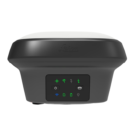
Page 42: Led Indicators On Gs18
3D viewer. Stake out the point. The values are valid for the tip of the pole. LED Indicators on GS18 LED indicators Description The GS18 instrument has Light Emitting Diode indicators. They indicate the basic instrument status. Operation... - Page 43 Undefined problem with tilt compensation RTK Base LED GS18 is in RTK rover mode or GS18 is switched off. green GS18 is in base mode, no RTK data is trans- mitted flashing GS18 is in base mode, RTK data is transmit- green ted to the selected port.
- Page 44 LED Status Status of the Instrument RTK Rover GS18 is in RTK base mode or GS18 is switched off. green GS18 is in rover mode, no RTK data is received via selected port. flashing GS18 is in rover mode, RTK data is received green via selected port.
-
Page 45: Guidelines For Correct Results With Gnss Surveys
Guidelines for Correct Results with GNSS Surveys Undisturbed satellite Successful GNSS surveys require undisturbed satellite signal reception, espe- signal reception cially at the instrument which serves as a base. Set up the instrument in loca- tions which are free of obstructions such as trees, buildings or mountains. Steady instrument for For static surveys, the instrument must be kept perfectly steady throughout the static surveys... -
Page 46: Care And Transport
Shipping When transporting the product by rail, air or sea, always use the complete orig- inal Leica Geosystems packaging, container and cardboard box, or its equiva- lent, to protect against shock and vibration. Shipping, transport of... - Page 47 Cables and plugs Keep plugs clean and dry. Blow away any dirt lodged in the plugs of the con- necting cables. Connectors with dust Wet connectors must be dry before attaching the dust cap. caps Care and Transport...
-
Page 48: Technical Data
The following accuracies, given as root mean square, are based on measure- ments processed using Leica Infinity and on real-time measurements. The use of multiple GNSS systems can increase accuracy by up to 30% relative to GPS only. -
Page 49: Technical Data
1.23/2.71 Recording Data (Leica GNSS raw data and RINEX data) can be recorded on the SD card. 1 GB is sufficient for over 1 year of raw data logging based on logging every 15 s from an average of 15 satellites. - Page 50 7 h continuously Base with cellular modem 6 h continuously with radio modem 5 h continuously 1 W output power Electrical data Type GS18 Voltage Current Frequency GPS L1 1575.42 MHz ü GPS L2 1227.60 MHz ü GPS L5 1176.45 MHz ü...
-
Page 51: Conformity To National Regulations
Hereby, Leica Geosystems AG, declares that the radio equipment type • GS18 is in compliance with the essential requirements and other rele- vant provisions of Directive 2014/53/EC and other applicable European Directives. The declaration of conformity can be consulted at http:// www.leica-geosystems.com/ce. -
Page 52: Gs18
Leica Geosystems has developed Guidelines on “How to carry Leica products” and “How to ship Leica products” with Lithium batteries. Before any transportation of a Leica product, we ask you to consult these guidelines on our web page (http://www.leica-geosystems.com/ dgr) to ensure that you are in accordance with the IATA Danger- ous Goods Regulations and that the Leica products can be transpor- ted correctly. -
Page 53: Software Licence Agreement
Leica Geosystems. Such software is protected by copyright and other laws and its use is defined and regulated by... -
Page 54: Appendix A Pin Assignments And Sockets
Appendix A Pin Assignments and Sockets Description Some applications require knowledge of the pin assignments for the instru- ment ports. In this chapter, the pin assignments and sockets for the instrument ports are explained. Pin assignments for port P1 PIN_001 Signal Function Direction... - Page 56 851580-1.0.0en Original text (851580-1.0.0en) Published in Switzerland © 2017 Leica Geosystems AG, Heerbrugg, Switzerland Leica Geosystems AG Heinrich-Wild-Strasse CH-9435 Heerbrugg Switzerland Phone +41 71 727 31 31 www.leica-geosystems.com...
Need help?
Do you have a question about the GS18 and is the answer not in the manual?
Questions and answers