Furuno NavNet 3D MFDBB Operator's Manual
Multi function display
Hide thumbs
Also See for NavNet 3D MFDBB:
- Installation manual (101 pages) ,
- Software instructions (9 pages) ,
- Installation manual (44 pages)
Table of Contents
Advertisement
Advertisement
Table of Contents

Related Manuals for Furuno NavNet 3D MFDBB


Summary of Contents for Furuno NavNet 3D MFDBB
- Page 1 MFDBB Multi Function Display www.furuno.co.jp...
-
Page 2: Important Notices
• Store this manual in a convenient place for future reference. • FURUNO will assume no responsibility for the damage caused by improper use or modification of the equipment (including software) by an unauthorized agent or a third party. -
Page 3: Safety Instructions
SAFETY INSTRUCTIONS The operator of this equipment must read these safety instructions before attempting to operate the equipment. Indicates a potentially hazardous situation which, if not avoided, WARNING could result in death or serious injury. Indicates a potentially hazardous situation which, if not avoided, CAUTION may result in minor or moderate injury. -
Page 4: Warning Labels
Warning labels are attached to the equipment. Code No.: 100-236-231 remove cover. No user-serviceable parts inside. Do not remove any label. If a label is missing or damaged, contact a FURUNO agent or dealer about replacement. Name: Warning Sticker WARNING... - Page 5 Safety Instructions This page is intentionally left blank.
-
Page 6: Table Of Contents
Table Of Contents Foreword ......................xi System Configuration ..................xiii Chapter 1: Operational Overview ..............1-1 Operating Controls .................... 1-1 Control Description ..................1-2 Inserting, Removing a Chart Card ..............1-4 Inserting a Chart Card..................1-4 Removing a Chart Card .................. 1-4 Precautions with Chart Cards ................. - Page 7 Table of Contents 2.10 Markers on the Chart Plotter Display ..............2-9 Boat Icon ......................2-9 Range Rings....................2-9 2.11 Chart Setup on the Chart Menu ..............2-10 2.12 Points ......................2-12 About Points ....................2-12 Entering a Point.................... 2-12 Following a Point ..................
- Page 8 Table of Contents Chapter 3: Radar Operation ................3-1 Transmitting, Stand-by ..................3-1 Adjusting the Gain ..................... 3-2 Suppressing Sea Clutter..................3-3 Suppressing Rain Clutter................... 3-4 Range Scale ...................... 3-5 Presentation Mode .................... 3-6 Description of Presentation Modes ..............3-6 Measuring the Range ..................
- Page 9 Table of Contents Track History Display ..................4-5 Selecting Track History Plotting Interval............4-5 Showing, Hiding the Track History Display ............ 4-5 ARPA Symbol Color..................4-6 Chapter 5: AIS Operation .................5-1 Enabling, Disabling AIS ..................5-1 AIS Target Symbols ..................5-1 Setting Acquisition Range .................
- Page 10 Table of Contents Troubleshooting....................8-3 General Troubleshooting ................8-3 Radar Troubleshooting ................... 8-3 Chart Plotter Troubleshooting ................. 8-4 Diagnostic Wizard....................8-4 Memory Test ....................8-4 Keyboard Test....................8-5 I/O Test ......................8-5 BBGPS Test....................8-5 Radar/ARPA Test ................... 8-5 GPS Status Display ................... 8-5 Restoring Default Settings.................
- Page 11 Table of Contents This page intentionally left blank.
-
Page 12: Foreword
3D series of multi function displays. We are confident you will see why the FURUNO name has become synonymous with quality and reliability. For over 50 years FURUNO Electric Company has enjoyed an enviable reputation for quality marine electronics equipment. This dedication to excellence is furthered by our extensive global network of agents and dealers. -
Page 13: Rotokeys
Foreword Other • Unique ROTOkeys (soft keys) provide quick access to functions of the active mode. • AIS Receiver FA-30 (option) receives AIS data (name of vessel, position, course, speed, etc.) from other vessels and shore stations and navigational aids and dis- plays this data. -
Page 14: System Configuration
System Configuration RADAR SENSOR RADAR SENSOR DRS2D/DRS4D DRS4A/DRS6A/DRS12A/DRS25A JOINT BOX POWER SUPPLY UNIT PSU-013 DISPLAY UNIT MU-155C/170C AIS RECEIVER, HEADING SENSOR or VIDEO IN EXTERNAL BUZZER (CCD CAMERA) GPS NAVIGATOR LINE OUT GP-320B (SPKR, ETC.) PROCESSOR UNIT MPU-001 USB DEVICE MIC IN (MOUSE, KYBD) (MICROPHONE) - Page 15 System Configuration This page is intentionally left blank.
-
Page 16: Chapter 1: Operational Overview
Chapter 1: Operational Overview This chapter provides the information necessary to get you started using your multi function display, from how to turn it on and off to how to read the main displays. This manual shows dedicated keys in bold face upper case letter; for example, DISP. All other labelled items such as ROTOkeys are shown in body text font. -
Page 17: Control Description
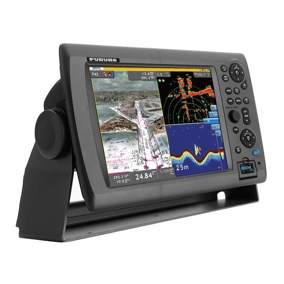
Chapter 1: Operational Overview Control Description The controls of your unit are shown in the figure below. Controls are backlit for easy viewing in nighttime use. DIsplay Control Unit (DCU12) GO TO LIST SHIP RANGE POINTS ROUTE DATA SAVE GAIN DISP MENU CANCEL... - Page 18 Chapter 1: Operational Overview Control description Key on PC or Label Function control on mouse SAVE/MOB SAVE(short push): Save current position as waypoint. MOB(long push): Save current position as MOB. CTRL key Switch active display. Scrollwheel. Spin or Rotary Knob •...
-
Page 19: Inserting, Removing A Chart Card
Chapter 1: Operational Overview 1.2 Inserting, Removing a Chart Card Before turning on the power, insert the chart card for your area in the card drive. Your multi function display can read C-MAP NT MAX/MAX2, Mapmedia and S52 cards. Inserting a Chart Card 1. -
Page 20: Turning The Power On/Off
Chapter 1: Operational Overview 1.3 Turning the Power On/Off Press the power switch to turn the power on. To turn the power off, press and hold down the switch until the screen goes blank. Shortly after the power is applied the lamp below the power switch lights (in green) and the start-up screen appears. -
Page 21: Selecting A Display
Chapter 1: Operational Overview 1.5 Selecting a Display Use the DISP key and ROTOkey to select a display. The displays available depend on the equipment you have in your NavNet system. In a later chapter you will learn how to customize the display selection to suit your needs and system configuration. 1. -
Page 22: Chart Plotter Display Overview
Chapter 1: Operational Overview 1.6 Chart Plotter Display Overview The chart plotter display provides a miniature world map. Detailed chart information is available when a chart card is inserted. The plotter section has facilities for waypoint entry and route construction and planning. A typical chart plotter display is shown in the illustration below. -
Page 23: Radar Display Overview
Chapter 1: Operational Overview 1.7 Radar Display Overview A radar system operates in the ultra-high-frequency (UHF) or microwave part of the radio-frequency (RF) spectrum, and is used to detect the position and movement of objects. Objects are shown on the radar display at their measured distances and bear- ings, in intensities according to echo strength. -
Page 24: Common Operations
Chapter 1: Operational Overview 1.8 Common Operations Moving the Cursor The cursor is the pointer you see on your display. Its main functions are • Find a position on the display • Select an item; for example, waypoint on the chart plotter To move the cursor, press on any of the four arrows on the Cursorpad to move the cursor in the direction indicated on the arrow pressed. -
Page 25: Display
Chapter 1: Operational Overview ROTOkeys The ROTOkeys are like "soft keys"; they change according to active display. The RO- TOkeys are hidden until you elect to display them. To display the ROTOkeys, simply rotate or push the Rotary Knob, and they appear at the right edge of the screen. By long-pushing the Rotary Knob you can display a greater quantity of ROTOkeys.
Need help?
Do you have a question about the NavNet 3D MFDBB and is the answer not in the manual?
Questions and answers