Furuno ECDIS FEA-2100 Chart Display Manuals
Manuals and User Guides for Furuno ECDIS FEA-2100 Chart Display. We have 3 Furuno ECDIS FEA-2100 Chart Display manuals available for free PDF download: Operator's Manual, Update Manual
Furuno ECDIS FEA-2100 Operator's Manual (470 pages)
Electronic Chart Display and Information System
Table of Contents
-
Introduction
25 -
-
Introduction29
-
Own Ship29
-
-
Chart Motion30
-
Chart Legend30
-
-
Chart Datum30
-
Cursor Datum30
-
Define Datum31
-
-
-
Move Chart31
-
Chart Type31
-
-
Alarms32
-
System Alarm32
-
-
-
-
Overview33
-
Positioning36
-
Monitoring38
-
-
ECDIS Screen
41 -
-
Verify Datum59
-
-
Introduction66
-
S57 Charts66
-
-
Introduction96
-
Permits96
-
Product List96
-
-
-
-
Telecomm129
-
-
Display Base139
-
-
-
ARCS Charts163
-
-
Chart Plan172
-
ARCS Catalogue182
-
-
-
-
Manual Updates
205-
Introduction205
-
-
Chart Alarms
221-
General221
-
Chart Alarms222
-
Route Planning229
-
Route Monitoring232
-
-
Navigation Tools
235-
Display Mode235
-
Navigation Marks236
-
-
Route Planning
239-
Introduction239
-
Select Datum241
-
-
Waypoint Sheet243
-
Prepare Sheet247
-
Optimization252
-
Backup to Floppy254
-
WP Table Report254
-
Full WP Report255
-
VOS Operations256
-
-
Route Monitoring
259-
Introduction259
-
How to Ask ETA264
-
-
-
Introduction267
-
Select Datum271
-
-
Point Sheet272
-
Symbol Sheet273
-
Line Sheet274
-
Tidal Sheet276
-
Area Sheet277
-
-
Backup to Floppy286
-
Point Report287
-
Line Report288
-
Symbols Report289
-
Full Report289
-
Report for Radar290
-
-
-
Introduction291
-
Select Datum293
-
Backup to Floppy297
-
-
Pilot Data
299-
Introduction299
-
Backup to Floppy306
-
-
-
Introduction307
-
Backup to Floppy309
-
-
-
Filter Operation322
-
Wind Sensor332
-
Depth Sensor333
-
Target Functions
335 -
-
Introduction343
-
-
Gain346
-
Noise Display348
-
Transparency348
-
Echo Stretch349
-
-
-
Introduction353
-
Voyage Recording354
-
Details Log354
-
Voyage Log355
-
Chart Usage Log359
-
Alarms Log363
-
-
-
Datum
365 -
Parameters Setup
367 -
-
Introduction377
-
-
Hand Steering378
-
Waypoint Mode378
-
Track Mode378
-
-
-
Course Control381
-
Radius Control381
-
Radar Steering382
-
-
-
Mode Goto Track384
-
Notes393
-
-
-
-
Notes408
-
Alarms
411-
Overview411
-
List of Alarms413
-
-
-
List of Terms431
-
Figure 1434
-
Figure 2434
-
Figure 3434
-
-
Appendix 1
435 -
Appendix 2
441-
-
Shallow Pattern443
-
-
Appendix 3
453-
C-MAP Charts453
-
-
Advertisement
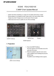
Furuno ECDIS FEA-2100 Update Manual (10 pages)
Furuno Marine GPS System User Manual
Brand: Furuno
|
Category: Marine GPS System
|
Size: 0 MB

Furuno ECDIS FEA-2100 Update Manual (10 pages)
Furuno Marine GPS System User Manual
Brand: Furuno
|
Category: Marine GPS System
|
Size: 0 MB
Advertisement
Advertisement