
Related Manuals for AvMap EKP-IV


Summary of Contents for AvMap EKP-IV
-
Page 1: User Manual
User Manual Via Caboto, 9 54036 Marina di Carrara - MS - ITALIA E-mail: info@avmap.it... - Page 2 In the event of a defect, AvMap, at its option, will repair or replace the product with no charge to the purchaser for parts or labor. The repaired or replaced product will be warranted for ninety (90) days from the date of return shipment, or for the balance of the original warranty, whichever is longer.
- Page 3 If too dry, the tissue won’t glide easily, and may damage the surface. Copyright 2004 AvMap Italy - All rights reserved No part of this User Manual may be reproduced or transmitted in any form or by any means, electronic or mechanical, including photocopying and recording, for any purpose other than the purchaser’s personal use...
- Page 4 User Manual...
-
Page 5: Table Of Contents
1.3.7 DATABASE .................... 18 2 The Basics ....................19 2.1 THE KEYBOARD ....................19 2.2 TURNING THE EKP-IV ON/OFF ............... 20 2.2.1 TURNING ON ..................20 2.2.2 TURNING OFF ..................21 2.3 CHANGING BRIGHTNESS & CONTRAST ..........21 2.4 SELECTING THE LANGUAGE ..............21 2.5 EXTERNAL CONNECTIONS .............. - Page 6 4 Navigation & Location ....................39 4.1 NAVIGATION & LOCATION DATA ..............39 4.2 SAVE CURRENT FIX AS USER WAYPOINT ............ 41 5 The HIS Screen ....................43 5.1 HSI DESCRIPTION ................... 43 5.2 HSI MENU ....................44 5.2.1 ADD MARK UNDER FIX ................. 44 5.2.2 SETUP DATAFIELDS ................
- Page 7 11.3 PRE TAKE-OFF ....................74 11.4 LANDING ....................74 12 Simulator ....................75 12.1 SIMULATING STRAIGHT MODE ..............75 12.2 SIMULATING ROUTE MODE ................75 12.3 TURNING THE SIMULATOR OFF ..............76 13 The Communication 77 13.1 NMEA OUTPUT ....................77 13.2 WAYPOINTS UPLOAD/DOWNLOADS ............
- Page 8 15 Operating Requirements ....................89 15.1 ANTENNA ASSEMBLY & PLACEMENT ............89 15.2 SECURING THE EKP-IV ................. 89 15.3 DIMENSIONS ....................90 15.4 TROUBLESHOOTING ..................91 15.4.1 POWER ....................91 15.4.2 GPS FIX ....................91 15.4.3 WHEN NOTHING ELSE WORKS ............92 15.4.4 CUSTOMER SUPPORT ...............
-
Page 9: Introduction
Designed as a sophisticated navigation information cen- ter, the features of the EKP-IV allow the user to Track information and navi- gate to points of interest. -
Page 10: Specifications
Power Cable (with cigarette lighter adapter) • Velcro Leg Strap • User Manual • Optional Accessories: C-Map NT + Regional Compact Flash • PC/Data cable • C-Map NT + Compact Flash (cartography and aeronautical data cards) are available through your local dealer. For additional information on C-MAP Cartography visit our web site at: http://aviation.c-map.com. -
Page 11: Physical Characteristics
Other Settings (User Points, Objects Overlap, Lat/Lon Grid) • Fix Functions DGPS • WAAS • Fix Symbol user selectable (Standard, Plane, Helicopter, Car) • Static Navigation • Course Predictor • Map Orientation (Track-up, Course-up, North-up) • Projected Radial • A-B measurement •... -
Page 12: Basic
1.2 BASIC Fig. 1.2 - How to insert the Compact Flash The EKP-IV is controlled by using 10 keys. As you press a key, a single audio beep confirms the key action; every time the key pressed is not valid, three rapid beeps sound indicating that no response is available. -
Page 13: Flying Start
EKP-IV. NOTE The EKP-IV is an aid to navigation. It does not replace paper charts and good judgement. 1.3.1 THE MOVING MAP Before starting, connect the EKP-IV to power and place the antenna with a clear view of the sky. -
Page 14: The Main Menu
To Change the Scale of the Moving Map Use ‘ZOOM IN’ and ‘ZOOM OUT’ to change the map display scale. To Select Position Use the cursor key to scroll to the location you want. 1.3.2 THE MAIN MENU From Moving Map press ‘MENU’ for 1 second to display the Main Menu: Fig. -
Page 15: Moving Map Icons
1.3.4 MOVING MAP ICONS The following icons are displayed on the Moving Map to represent Waypoints, navigation aids and airports. Fig. 1.3.4 - Moving Map Icons 1.3.5 COURSE PREDICTOR Indicates the projected position at the set time interval if the current speed and heading are kept. -
Page 16: Database
Waypoint and press ‘GOTO’. The GoTo menu box will open enabling you to activate the current cursor position or search the Database for a specific object to fly to. To activate the current cursor position, highlight “CURSOR” and press ‘ENTER’. To activate a GoTo Flight Plan to a specific Database item, select the category and press ‘ENTER’. -
Page 17: The Basics
The Power key ‘POWER’: press and hold to turn the EKP-IV On. ‘POWER’ 3 sec.: once the EKP-IV has been turned On turns the EKP-IV Off. ‘POWER’: (immediately release!) once the EKP-IV has been turned On displays the Brightness and the Contrast Menu. -
Page 18: Turning The Ekp-Iv On/Off
Before powering On the EKP-IV, check for the correct voltage (10-35 Volt DC). 2.2.1 TURNING ON Press and hold ‘POWER’ for 1 second. The EKP-IV emits one rapid beep sound and a Title page containing information about the Product name, Software version, library version and cartridges installed is displayed. -
Page 19: Turning Off
2.5 EXTERNAL CONNECTIONS 2.5.1 INTERNAL/EXTERNAL GPS SOURCE The EKP-IV has an internal GPS Receiver. Be sure the Fix Source is set to Internal GPS to receive data from this internal receiver. > ‘MENU’ 1 sec. + “SYSTEM SETUP” + ‘ENTER’ + “FIX SETUP” + ‘ENTER’ + “FIX SOURCE” + ‘ENTER’... -
Page 20: Nmea Outputs
NMEA sentences). Fig. 2.5.2 - NMEA Connections 2.5.3 DOWN OR UP-LOAD FLIGHT PLANS & TRACKS The EKP-IV can also send and receive Flight Plans from the C-MAP PC-PLAN- NER NT software program or another device compatible with it. This requires an optional power/data cable that can be purchased from your avionics dealer or C-MAP (see Fig. -
Page 21: System Setup Options
> ‘MENU’ 1 sec. + “COMMUNICATIONS” + ‘ENTER’ + “TRACK DOWNLOAD” + ‘ENTER’ 2.6 SYSTEM SETUP OPTIONS You may select how the EKP-IV displays primary information (such as how time is displayed) from the System Setup Menu. > ‘MENU’ 1 sec. + “SYSTEM SETUP” + ‘ENTER’... -
Page 22: Data Entry
2.7 DATA ENTRY Information is keyed into the EKP-IV when editing a Waypoint, entering a Flight Plan, using the calculator and searching the Database. When the field is highlighted: - Enter or edit data by pressing up/down cursor key to step through the avail- able characters until the desired character is displayed. -
Page 23: The Moving Maps
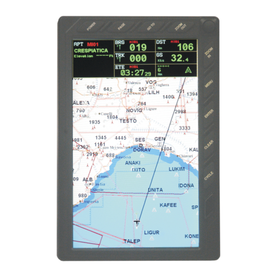
The Moving Maps The Moving Map is the default state of the software. This mode displays the Mov- ing Map screen and Data Window. The Moving Map displays map detail in Home, Auto Zoom or Cursor mode. The operation mode will determine the options available within the screen. -
Page 24: Auto Zoom Mode
NOTE Auto Zoom must be selected to Off in the Moving Map Menu. A slow flashing airplane icon will indicate your current position. The airplane will be pointing in the direction of movement. Home mode can display the map in North-up, Course-up or Track-up (see Moving Map Settings, Par. 3.5). To deactivate Home mode press ‘CLEAR’... -
Page 25: Automatic Info
3.3 AUTOMATIC INFO Automatic Info will provide details on cartographic objects, Waypoints and navaid items when the cursor is placed over them. This is a user setting that can be defined in Moving Map Menu. The default is Automatic Information to be displayed for aeronautical and terrestrial data. -
Page 26: Airspace Information
If no object is present, an error message stating “Ob- ject not found” will appear on the screen. The EKP-IV will store 10 radials. To project a radial, first select the object with the cursor, then: >‘ENTER’... -
Page 27: Waypoint Handling
A shadow of the icon will remain on the screen until the map is redrawn. 3.4.6 FLIGHTPLAN The EKP-IV provides storage for 10 Flight Plans of 100 legs each. From the Moving Map screen you can edit and create Flight Plans using the cursor. The Flight Plan edited or created will be the one that is currently viewed by the software (see Chapter 6). -
Page 28: Moving Map Menu
Map display. Here you can define the items for display, Map Orientation, Auto Zoom, se- lective display and other settings to customize the EKP-IV for your naviga- tional needs. From Moving Map press ‘MENU’ to display the Moving Map Menu. From here use the cursor key to select the item desired and press ‘ENTER’... -
Page 29: Viewed Fp
Fig. 3.5 - Moving Map Menu 3.5.1 VIEWED FP This item enables you to select the Flight Plan to display on the Moving Map from the list of stored Flight Plans. The Flight Plan that is “Viewed” can then be edited or activated from the Moving Map display. >... -
Page 30: Data Window Mode
Auto Zoom is On the Auto Zoom mode is activated (see Par. 3.1.3). > ‘MENU’ + “AUTO ZOOM” + “ON”+ ‘ENTER’ The Auto Zoom mode is used to keep the fix position and the destination (Target) visible on the map. The map is scrolled and zoomed automatically to keep the best view possible. -
Page 31: Default Datafields
Fig. 3.5.3 - Setup Data Fields > ‘MENU’ + “SETUP DATA FIELDS” + ‘ENTER’ After pressing ‘ENTER’, a box in the Data Window will be highlighted. Using the cursor key, select the box to be edited and press ‘ENTER’. The OPTIONS box will appear (see previous figure) allowing you to select the item to display in the highlighted is box. -
Page 32: Map Presentation Settings
> ‘MENU’ + “MAP ORIENTATION” + ‘ENTER’ The options are: Track-up - will rotate the map automatically to keep your Track pointed to- ward the top of the display (see Par. 14.2.6; System Setup + Fix Setup + Head Up Response). Course-up - will rotate the map automatically to keep your active leg pointed toward the top of the display. -
Page 33: Vfr, Airspace, Land, Marine And Other Settings
egory of detail selected will be displayed on the Moving Map automatically when the cursor is placed over the object. > ‘MENU’ + “AUTOMATIC INFO” + ‘ENTER’ The selection options are: OFF/AERO+TERREST /AERONAUTICAL/ TERRESTRIAL/MARINE (refer to Par. 3.3). If the category is turned Off, no details about objects will be displayed automatically. -
Page 34: Selective Display Settings
3.5.8.4 Marine Settings The Marine Settings menu controls the detail shown from a C-MAP Marine Compact Flash. Lights: ON/OFF/NO SECTOR. When Lights are On lights are shown on lighthouses and other lights that rotate, a light sector is displayed to show the range of coverage for the light. - Page 35 It is also possible tochoose the catrografic information to be shown based on the selected "Cycle" program. There are 3 programs available thatthe user can personalize through the 1/2/3 Cycle columns. For each of them it is possible to activate/deactivate any carto- graphic object.
- Page 36 User Manual...
-
Page 37: Navigation & Location
Navigation & Location The Navigation and Location screen displays a full page of navigation informa- tion with location coordinates. To access from the Main Menu: > ‘MENU’ 1 sec. + “NAV/LOCATION” + ‘ENTER’ Fig. 4 - Nav/Location screen 4.1 NAVIGATION & LOCATION DATA The Navigation data displayed in this window is based on the current Flight Plan leg or active Waypoint. - Page 38 To change the CDI scale press the left/right cursor key. The EKP-IV references navigation information to the next Waypoint in the active Flight Plan. When you reach the destination of one leg, the EKP-IV automatically switches to the next leg.
-
Page 39: Save Current Fix As User Waypoint
4.2 SAVE CURRENT FIX AS USER WAYPOINT You can save your current position as a User Waypoint while viewing the Nav/Location page by pressing ‘ENTER’. A warning box will appear to con- firm your desire to add the Waypoint, displaying the default Waypoint name. Press ‘ENTER’... - Page 40 User Manual...
-
Page 41: The His Screen
The HIS Screen The HSI screen presents the desired course to be flown and the current Track in a graphical format similar to the Horizontal Situation Indicator of an air- craft; using the compass rose as the center of the display. From Moving Map: >... -
Page 42: Hsi Menu
5.2 HSI MENU When on the HSI screen, pressing ‘MENU’ will access the HSI Menu with the following options: Add Mark under Fix, Setup Data Fields, Default Data Fields and Compass Orientation. 5.2.1 ADD MARK UNDER FIX While in HSI mode, it is possible to create a User Mark under the current position fix. -
Page 43: Flight Plan
Moving Map (see Par. 3.5) or in the Flight Plan Menu if all Waypoints are known objects. The EKP-IV can store up to 10 Flight Plans with up to 100 individual legs each. Additional Flight Plans can be stored via the User Compact Flash. -
Page 44: Creating A Flight Plan From The Database
is for the current “Viewed” Flight Plan. The Flight Plan name will appear at the top of the page. All actions within the Flight Plan menu are related to the currently “Viewed” Flight Plan. To select the Flight Plan to view: >... -
Page 45: Naming A Flight Plan
This will activate/deactivate the currently Viewed Flight Plan (See Sec.3.5.1.). 6.4 NAMING A FLIGHT PLAN The EKP-IV allows you to create a user defined name of 12 alphanumeric char- acters for each Flight Plan. This name will appear at the top of the page when viewed and in the Flight Plans List when viewing all Flight Plans. -
Page 46: Reverse A Flight Plan
Database menu will appear (see Chapter 8 for details on search- ing the Database Menu). Once the desired object has been found, press ‘GOTO’ to activate. NOTE ‘GOTO’ creates a temporary Flight Plan that is not stored in the EKP-IV memory. User Manual... -
Page 47: Nearest Search For Goto Flight Plan Activation
6.8 NEAREST SEARCH FOR GOTO FLIGHT PLAN ACTIVATION Pressing ‘PAGE’ at any time will provide a list of the 20 Nearest Database objects. The first page to appear will be the last chosen category of data. To select another category of data, press ‘MENU’ to display the available catego- ries. - Page 48 User Manual...
-
Page 49: The Global Positioning System
The Global Positioning System The Global Positioning System (GPS) is a constellation of satellites that orbit the earth twice a day, transmitting precise time and positioning information to anywhere on the globe, 24 hours a day. The system was designed and deployed by the U.S. Department of Defense to provide continuous, worldwide positioning and navigation data to U.S. -
Page 50: Gps Receiver Specifications
Azimuth and Elevation of the satellites used to compute a position fix. The Elevation is the height of the satellite above the horizon, with 5° (lowest) near the horizon and 90° (highest) being directly overhead (the EKP-IV does not normally use satellites with Elevations lower than 10°). Azimuth is the satellite’s location in relation to true north, measured clockwise as a bearing. -
Page 51: Accuracy
exactly where to find the best possible replacement). Three satellites are required for two-dimension positioning (which determines position only) and four satellites are required for three-dimension positioning (to determine position and elevation). 7.3.1 ACCURACY In general, an SPS receiver can provide position information with an error of less than 25 Meters and velocity information with an error of less than 5 Meters per second. -
Page 52: Monitoring & Controlling The Gps
ceiver accepts and demodulates the broadcast corrections, which are then re- layed to the GPS receiver. The GPS receiver applies the corrections to the navigation data it uses to compute a position solution and displays differen- tially corrected data. Care must be taken to ensure that the DGPS receiver and the GPS receiver are compatible for this procedure to be successful. -
Page 53: Waypoint & Database
Waypoint Database page. Like the Jeppesen Waypoints, they can be used in a Flight Plan, for the Nearest Search or GoTo functions. The EKP-IV can store up to 1,000 User-Defined Waypoints within the internal memory. The internal waypoint memory capacity is shared with Flight Plan waypoints;... -
Page 54: Saving Present Position - Moving Map Methods
a User Waypoint at the cursor position: > ‘ENTER’ + “ADD WAYPOINT” + ‘ENTER’ A name is automatically assigned in the format “USRxxx”, where “xxx” is a sequential number. You may use the default display name, LAT/LON and symbol or edit them. NOTE When editing the waypoint, select the “picture”... -
Page 55: Editing User Waypoints - Database Methods
> ‘MENU’ 1 sec + “DATABASE” + ‘ENTER’ Options are: Airports, VOR, NDB, Intersections, User Waypoints. A window shows the different categories of Database items within the EKP-IV. Highlight the category to be searched and press ‘ENTER’. Depending upon the category of object, the Database can be searched by one of three methods: identifier, name or city (and in the Pro version;... - Page 56 Upon entering the Database page for the selected item, (except User Waypoints) the EKP-IV will default the ID box for search criteria by placing a box around the field name. If you would like to search by another field, press the up/down cursor key to select the field and press ‘ENTER’...
- Page 57 within the same city, the double sided cursor key will scroll through each airport within the city. When displaying Airport data, press the left/right cursor key for additional details on the airport frequencies and runway data. Remember to key in the ICAO prefix (“K” for the United States) at the beginning of airport identifiers, where applicable (see Appendix 4 for details).
- Page 58 User Manual...
-
Page 59: Approach Data Procedures
Approach Data Procedures WARNING: The EKP-IV is not certified for use as the only navigation device during Instrument Flight Rules as established by the FAA. Instrument approach points displayed in the unit are for information only and do not establish authority for a pilot to fly the IFR approach procedure in actual instrument flying conditions. -
Page 60: Approach From Flight Plan Database
Flight Plan mode allows the pilot to plan and activate up to ten flight plans with up to 100 individual legs each. Now the EKP-IV allows the pilot to pre- program an approach at the destination end of the flight plan and to change the approach as desired. - Page 61 GOTO destination replacing them with the corresponding airport waypoint (that was originally selected). Activating a GOTO with an Approach from database If you are in the airports database page > ‘MENU’ + ‘MENU’ + “DATABASE” + “AIRPORTS” and the screen is displaying approach information, by pressing ‘GOTO’ you will activate a ‘GOTO’...
- Page 62 User Manual...
-
Page 63: Calculator
Calculator The Calculator functions assist the user in preflight and in-flight calculations for Vertical Navigation, Wind and Fuel consumption. In addition, clock func- tions and trip data can be found in this menu. The Calculator uses GPS data and user data for computations. All Calculator functions are based on the active Flight Plan. -
Page 64: Elapsed Timer
‘ENTER’ to confirm or ‘CLEAR’ to quit and continue the timer calculation. The default setting is Off (00:00:00). 10.3 TRIP COMPUTER The EKP-IV provides a calculation page which tracks speed, flying time, and distance traveled. This data is statistical in nature and is calculated based on GPS parameters. -
Page 65: Vertical Navigation
Fig. 10.3 - Trip Computer page Flying Avg: Speed values above 35 knots divided by flying time. Overall Avg: Speed values divided by Partial Distance. Maximum Speed: Fastest speed reached Current Speed: Current GPS speed. Flying Time: Total time when speed is greater than 35 knots. Stopped Time: Total time unit was on with a GPS fix and speed was less than 2 knots. - Page 66 for the values entered here are selected from Units Setup menu in the System Setup Menu, see Par. 14.5). This feature requires that a Flight Plan be activated. > ‘MENU’ 1 sec.+ “CALCULATOR” + ‘ENTER’ + “VERTICAL NAVIGATION” + ‘ENTER’ User data is entered in the fields at the bottom half of the screen.
-
Page 67: Wind Calculation
Fig. 10.4a - Vertical Navigation function Vertical Navigation can be activated (On) only if a Flight Plan is active (desti- nation present). Destination point for Vertical Navigation is the last point of the Route or destination of GoTo mode. Prior to the Descent Point being reached the Distance To Go displays TO, Time To Go to Descent point and Descent Rate from the current position. -
Page 68: Fuel Consumption
5%. 10.6 FUEL CONSUMPTION The EKP-IV computes Fuel Consumption for each leg of the active Flight Plan or the fuel used in flight, based on entries made by the pilot. This is a useful feature for flight planning purposes. Actual Fuel Consumption will vary based on flight conditions and engine settings. - Page 69 Press ‘CLEAR’ to return to the Calculator Menu. If your current Ground Speed is over 20 Knots, the EKP-IV will display “Ac- tual GS” and will not allow you to edit the value.
- Page 70 Fig. 10.6a - Sample Calculation User Manual...
-
Page 71: The Checklists
The Checklists The EKP-IV provides a checklist of standard procedures for Engine Start, Ground Check, Pre-Take-off, and Landing. NOTE Your aircraft may have additional items that require checking for each procedure. Consult your aircraft manual for a complete list. > ‘MENU’ 1 sec. + “CHECKLISTS” + ‘ENTER’... -
Page 72: Ground Check
11.2 GROUND CHECK > ‘MENU’ 1 sec. + “CHECKLISTS” + ‘ENTER’ + “GROUND CHECK” + ‘ENTER’ After pressing ‘ENTER’ select each item (Brakes/Steer, Props/Mags, Vacuum, Oil Tmp/Press, Fuel Pressure, Carb. Heat, Ammeter, Primer-Locked, Flt Con- trols, Lights). Press ‘ENTER’ to mark each item after checking is completed. If all the items of the list are not checked upon exit a warning message appears on the screen that states the check-list has not been completed. -
Page 73: Simulator
Simulator The built-in Simulator function allows you to become proficient in the use of the EKP-IV before ever taking it into the cockpit. No current position fix is required because the EKP-IV simulates position data internally. The EKP-IV simulates flight in two ways: a straight flight path or following a selected route. -
Page 74: Turning The Simulator Off
As stated earlier, in the Simulation mode the EKP-IV retains full functionality. It is recommended that the Simulator be used to experiment with the full range of capabilities contained within the EKP-IV so that you may get the most out of it when used in the cockpit. 12.3 TURNING THE SIMULATOR OFF... -
Page 75: The Communication
Fig. 13 - Communications Menu 13.1 NMEA OUTPUT The EKP-IV can be attached to external equipment that accepts GPS data in- put (see Chapter 15 for wiring). Once attached, the output of NMEA format- ted data can be enabled in the following manner: >... -
Page 76: Flight Plan Upload/Download
>‘MENU’ 1 sec. + “COMMUNICATIONS” + ‘ENTER’ + “WAYPOINTS DOWNLOAD” + ‘ENTER’ 13.3 FLIGHT PLAN UPLOAD/DOWNLOAD The Upload Flight Plan function allows the unit to receive a Flight Plan from the serial port using the NMEA0183 $WPL and $RTE sentences (see Appendix F): >... -
Page 77: The System Set-Up Menu
The System Set-up Menu The System Setup Menu allows the user to change how the EKP-IV displays information. System Setup options are arranged in sub-menus. For example, all options that relate to the Fix functions are in Fix Setup sub-menu and all options related to time or date are in Date Time Setup. -
Page 78: Scale Format
> ‘MENU’ 1 sec. + “SYSTEM SETUP” + ‘ENTER’ + “FIX SETUP” + ‘ENTER’ 14.2.1 FIX SOURCE The EKP-IV uses positioning information provided by the internal GPS-re- ceiver or by an external NMEA 0183, external Air Data, or External RNAVdata string. -
Page 79: Differential Correction Source
TION” + ‘ENTER’ 14.2.5 COURSE PREDICTOR The EKP-IV will display a line with a circle at the end to indicate the position your aircraft will reach at the set time, based on current direction of travel and speed. This is continuously updated to account for changes. -
Page 80: Alarm Set-Up
Setting options are: +/-5, +/-10, +/-15, +/-45, +/-90. The default setting is +/-15. 14.3 ALARM SET-UP The EKP-IV provides alarm settings for various functions. Here you can set the system for your navigational requirements. > ‘MENU’ 1 sec. + “SYSTEM SETUP” + ‘ENTER’ + “ALARM SETUP” + ‘ENTER’... -
Page 81: Airspace Ahead Alarm
(or ‘CLEAR’ to abort function). The message “DONE” will appear con- firming the action. 14.4 TRACK SET-UP Track is the actual course traveled, which the EKP-IV can display as a series of connected dots. The interval setting can be defined by the pilot. -
Page 82: Track Display
> ‘MENU’ 1 sec. + “SYSTEM SETUP” + ‘ENTER’ + “TRACK SETUP” + ‘ENTER’ + “TRACK DIS- PLAY” + ‘ENTER’ 14.4.2 TRACK RECORDING STEP The EKP-IV stores up to 5,000 data points to display a pattern of aircraft move- ment (Track). After 5,000 intervals the oldest is deleted with each new position fix point. The following options assist in getting the most track memory for your type of flying. -
Page 83: Distance Unit
14.5.1 DISTANCE UNIT > ‘MENU’ 1 sec. + “SYSTEM SETUP” + ‘ENTER’ + “UNITS SETUP” + ‘ENTER’ + “DISTANCE” + ‘ENTER’ Distance measurements can be displayed in Statute Miles (SM), Nautical Miles (NM) or kilometers (KM). The default setting is NM. 14.5.2 SPEED UNITS >... -
Page 84: North Reference
OSGB. The default setting is DDD MM.mm. 14.6 DATE & TIME SET-UP These functions control how the EKP-IV displays time and date settings. > ‘MENU’ 1 sec. + “SYSTEM SETUP” + ‘ENTER’ + “DATE & TIME SETUP” + ‘ENTER’ 14.6.1 TIME FORMAT >... -
Page 85: Data Format
> ‘MENU’ 1 sec. + “SYSTEM SETUP” + ‘ENTER’ + “DATE & TIME SETUP” + ‘ENTER’ + “DATE FORMAT” + ‘ENTER’ The EKP-IV displays dates as MM/DD/YY – Month/Day/Year or DD/MM/ YY – Day/Month/Year. The default setting is MM/DD/YY. 14.7 COLORS SET-UP >... -
Page 86: Factory Defaults
The message “DONE” will appear confirming the action. 14.10 FACTORY DEFAULTS This will restore the EKP-IV to all factory default settings. > ‘MENU’ 1 sec. + “SYSTEM SETUP” + ‘ENTER’ + “FACTORY DEFAULTS” + ‘ENTER’ After pressing ‘ENTER’ a window appears; press ‘ENTER’ to confirm , or ‘CLEAR’... -
Page 87: Operating Requirements
Operating Requirements The EKP-IV must be connected to a 10–35 V DC power source and the an- tenna requires a clear view of the sky in order to operate. Fig. 15 - Power and I/O Connector NOTE The cable that ends with wires is available as an optional part. Please contact your local C-MAP office for details. -
Page 88: Dimensions
Please contact your dealer for more details on these items. NOTE Yoke mounts may not be appropriate for your aircraft. Use care to ensure that the EKP-IV does not obscure the primary instruments. 15.3 DIMENSIONS Fig. -
Page 89: Troubleshooting
Selective Availability which was discontinued in April 2000. The EKP-IV is not obtaining position fixes — If the EKP-IV is using an internal GPS Receiver, proceed to the GPS status screen: >‘MENU’ 1 sec. + “GPS PAGE” + ‘ENTER’... -
Page 90: When Nothing Else Works
The EKP-IV may not be properly connected to the external device. Check all connections to be sure they are correctly made and secure. Navigate feature does not work — Blanks are displayed in the navigation data fields until a GPS fix has been obtained; this usually occurs within a few Min- utes. -
Page 91: System Test
Fig. 15.4.4 - About page If it is necessary to return your EKP-IV for repair, you must obtain a return authorization (RA) number from C-MAP Aviation prior to shipping the sys- tem. Include with the EKP-IV a description of the problem, your RA number, and your name and address. -
Page 92: C-Card Menu
cursor key to select the RAM Menu and press ‘ENTER’ to select RAM Test or RAM Clear. RAM Test • ‘ENTER’ on RAM Test to verify the integrity of the RAM. If the message “ERROR” appears the RAM is physically damaged. RAM Clear •... - Page 93 If the data displayed on the screen is unrecognizable, you may have selected the wrong input parameters for your particular receiver, for example, NMEA- 0182 instead of NMEA-0183. Check your receiver manual to be sure that you have selected the proper inter- face format.
-
Page 94: Appendix A - Terms
This section explains the terms that you may find unfamiliar. ACQUISITION Occurs when the EKP-IV locates a signal and collects data from a satellite. AIRPORT DATABASE A series of files of airport positions (described near the geographical center of the airport and as defined by ICAO), with runways, frequencies (with sectors) and services available information. - Page 95 Identified by a unique name, such as WGS84 or NAD27. DEFAULT The value or setting automatically chosen by the EKP-IV unless directed otherwise. DEGREE 1/360th of a circle. On a Great Circle, 1° = 60 min.
- Page 96 MASK ANGLE The Elevation (height above the horizon, measured in Degrees) below which the EKP-IV will not search for satellites. The Mask Angle used by the EKP-IV is variable. It starts at 8° and under certain condi- tions, may drop as low as 0°.
-
Page 97: Appendix C - Map Datum
UTC UNIVERSAL TIME - The current time at the Prime Meridian. Abbreviated as UT or UTC. Also ref. to as Zulu time (Z) USER COMPACT FLASH The EKP-IV uses the optional User COMPACT FLASH to save user data: it is a convenient medium to store and retrieve your information. - Page 98 tags, the ICAO codes minimize the possibility of duplicate identifiers and allow pilots to identify an airport’s region and nearby large city. ICAO codes for international airports use a 2-character identifier for the region, followed by 1 character that identifies the airport’s general area, then 1 character of the airport. For example, the ICAO code for Melbourne, Australia is YMML (IATA code MEL).
- Page 99 ICAO ICAO CODE NAME CODE NAME Botswana Antarctica (Aus/NZ) Brazzaville/Congo Greenland Swaziland Iceland Central African Republic Miquelon Island/St Pierre Island Equatorial Guinea (Canada) Canada Acension/St. Helena Mauritius Algeria Benin British Indian Ocean Tr/Chagos Archi- pelago Burkina Faso Cameroon Accra/Ghana Zambia Ivory Coast Antananarivo/Cormors/Madagascar/ Nigeria...
- Page 100 ICAO ICAO CODE NAME CODE NAME Dakar/Dakar Oceanic/Senegal Guatemala Mauritania Honduras Guinea Republic Jamaica Cape Verde/Sal Oceanic Mexico Ethiopia Nicaragua Burundi Panama Somalia Costa Rica Egypt El Salvador Djibouti Haiti Kenya/Nairobi Cuba Libya Cayman Islands Rwanda Bahamas Sudan Belize Tanzania Cook Islands Uganda Fiji Islands/Tonga...
-
Page 101: Appendix E - C-Map Aviation Cartridge Options
Appendix E - C-MAP Aviation Cartridge Options The EKP-IV displays land cartography and navigational data from C-MAP data cards. The system is designed with land cartography internal to the hardware and two Compact Flash slots for additional external data. Follow- ing are the data options for the EKP-IV. -
Page 102: Appendix F - C-Map Data Transfer
REGIONAL CARTOGRAPHY You can enhance the level of detail found in the internal memory with regional Compact Flashs. The additional street and lake information provides more detail and increased accuracy of the land cartography on the lower zoom levels of the unit. CUSTOMIZED REGIONAL COVERAGE AREA C-MAP’s customized regional coverage option can provide you with the opportunity to create a Compact Flash centered around your home town.
Need help?
Do you have a question about the EKP-IV and is the answer not in the manual?
Questions and answers