Table of Contents
Advertisement
Quick Links
Advertisement
Table of Contents

Subscribe to Our Youtube Channel
Related Manuals for Leica Viva GS10


Summary of Contents for Leica Viva GS10
- Page 1 Leica GS10/GS15 User Manual Version 4.1 English...
- Page 2 The type and serial number of your product are indicated on the type plate. tion Enter the type and serial number in your manual and always refer to this information when you need to contact your agency or Leica Geosystems authorised service work- shop. Type: _______________ Serial No.:...
- Page 3 Symbols The symbols used in this manual have the following meanings: Type Description DANGER Indicates an imminently hazardous situation which, if not avoided, will result in death or serious injury. WARNING Indicates a potentially hazardous situation or an unintended use which, if not avoided, could result in death or serious injury.
- Page 4 GS10/GS15, Introduction Validity of this This manual applies to the GS10/GS15. manual Available docu- Name Description/Format mentation GS10/GS15 Provides an overview of the product together with tech- Quick Guide nical data and safety directions. Intended as a quick reference guide. GS10/GS15 All instructions required in order to operate the product User Manual...
- Page 5 Manual ware functions intended for technical specialists. Refer to the following resources for all GS10/GS15 documentation/software: • the Leica Viva Series DVD • https://myworld.leica-geosystems.com myWorld@Leica Geosystems (https://myworld.leica-geosystems.com) offers a wide range of services, information and training material.
- Page 6 View the service history of your products in Leica Geosystems Service Centers and detailed information on the services performed on your products. For your products that are currently in Leica Geosystems Service Centers view the current service status and the expected end date of service.
-
Page 7: Table Of Contents
Table of Contents In this manual Chapter Page Description of the System System Components System Concept 1.2.1 Software Concept 1.2.2 Power Concept 1.2.3 Data Storage Concept Instrument Components User Interface Keyboard Operating Principles Operation Equipment Setup 3.1.1 Connecting to a Personal Computer 3.1.2 Connecting to the Web Server 3.1.3... - Page 8 GS10/GS15, Table of Contents 3.2.1 Operating Principles 3.2.2 Battery for GS10 3.2.3 Battery for GS15 Working with the Memory Device Working with the RTK Device 3.4.1 GS10 3.4.2 GS15 LED Indicators on GS10/GS15 Guidelines for Correct Results with GNSS Surveys Care and Transport Transport Storage...
- Page 9 Electromagnetic Compatibility EMC FCC Statement, Applicable in U.S. Technical Data GS10/GS15 Technical Data 6.1.1 Tracking Characteristics 6.1.2 Accuracy 6.1.3 Technical Data Antennas Technical Data Conformity to National Regulations 6.3.1 GS10 6.3.2 GS15 6.3.3 GFU24, Siemens MC75 6.3.4 GFU19 (US), GFU25 (CAN) CDMA MultiTech MTMMC-C 6.3.5 GFU28, Telit UC864-G 6.3.6...
- Page 10 GS10/GS15, Table of Contents International Limited Warranty, Software Licence Agreement Appendix A Pin Assignments and Sockets GS10 GS15 Index...
-
Page 11: Description Of The System
To receive the satellite signals from the GNSS satellites. LEICA Geo Office The office software including a series of help programs which support working with Leica Viva Series instruments. Instruments Depending on the satellite systems and signals configured, a maximum number of 120 channels is allocated. - Page 12 The GS GNSS instruments are additionally designed to support Compass. The Compass signal definition is not fully finalised, although, test signals have been tracked in a test environment. As changes can still occur, Leica Geosystems cannot guarantee full Compass compatibility.
-
Page 13: System Concept
System Concept 1.2.1 Software Concept Description All instruments use the same software concept. Software for all GS Software type Description GNSS instruments GS firmware This important software covers all functions of the instru- (GS_xx.fw) ment. The Web server application is integrated into the firmware and cannot be deleted. - Page 14 All GS models The software can be uploaded using the Leica Web server application or myWorld@Leica Geosystems. Ensure that a Leica SD card is inserted into the GS instrument before starting the upload. Refer to "3.3 Working with the Memory Device".
-
Page 15: Power Concept
General Use the Leica Geosystems batteries, chargers and accessories or accessories recom- mended by Leica Geosystems to ensure the correct functionality of the instrument. Power options Power for the instrument can be supplied either internally or externally. Up to two external power supplies can be connected. - Page 16 GS10/GS15, Description of the System For permanent operations use Uninterruptible Power Supply units as a back-up in a main power failure.
-
Page 17: Data Storage Concept
1 GB. While other SD cards can be used, Leica Geosystems recommends to only use Leica SD cards and is not responsible for data loss or any other error that can occur while using a non-Leica card. Unplugging connecting cables or removing the SD card during the measurement can cause loss of data. -
Page 18: Instrument Components
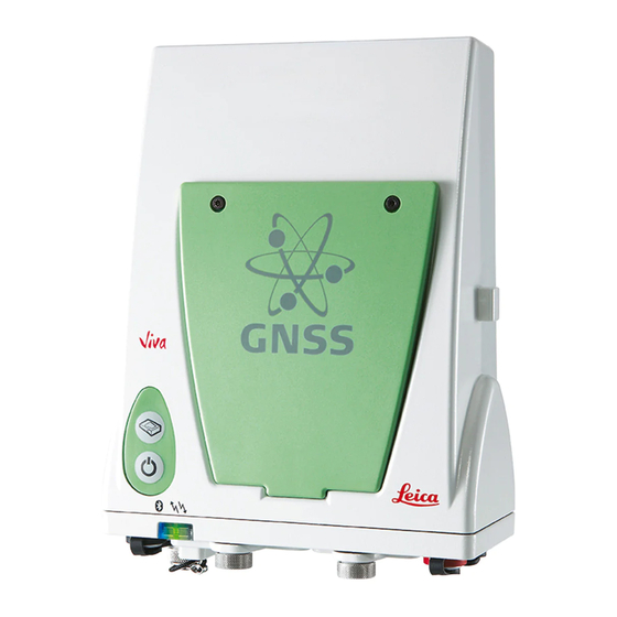
GS10/GS15, Description of the System Instrument Components The instrument can be preprogrammed using the Web server application running from the instrument on a web browser of a Windows device. In this case, the instrument is turned on by holding down the ON/OFF button for 2 s or off by holding down the ON/OFF button for 2 s. - Page 19 GS15 components a) RTK device compartment including port P3 b) RTK device LEDs c) Battery compartment 2 d) LEDs, ON/OFF button and Function button e) LEMO port P1 including USB port QN-connector for external UHF or digital cellular phone antenna g) LEMO port P2 h) Battery compartment 1 with SD card slot...
-
Page 20: User Interface
GS10/GS15, User Interface User Interface Keyboard Keyboard GS10 a) ON/OFF button b) Function button GS_082 Keyboard GS15 a) ON/OFF button b) Function button GS_080...
Need help?
Do you have a question about the Viva GS10 and is the answer not in the manual?
Questions and answers