Table of Contents
Advertisement
Advertisement
Table of Contents

Related Manuals for CHC X20+GPS


Summary of Contents for CHC X20+GPS
- Page 1 ETTING TARTED UIDE X20+GPS...
-
Page 2: Table Of Contents
5.3 PPK Configuration…………………………………………………………………………………………………………13 6.Download static data from X20+ receiver……………………………………………..…………………….……13 7. PPK surveying..........................18 7.1 Installation of the CHC PPK Software in PDA..............18 7.2 Launch the HCDiff to carry out Surveying Project..............19 7.2.1 Establish Bluetooth Connection with X20+ GPS............19 7.2.2 Carrying out PPK surveying..................20... -
Page 3: Introduction
Technical Assistance Your Comments Thank you for choosing CHC X20+GPS receiver. This Getting Started Guide is designed to help you rapidly familiarize yourself with your new equipment. 1.1 Technical Assistance If you have a problem and cannot find the information you need in... -
Page 4: Overview
Features Specification 2.1 Safety Information This manual describes CHC X20+ GPS Receives. Before using your receiver make sure that you have read and understood this publication, as well as safety requirements. 2.1.1 Warning and Cautions An absence of specific alerts does not mean that there are no safety risks involved. -
Page 5: Features
Overview 2.2 Features The X20+ receiver provides the following features: Single Lithium-ion rechargeable battery RS232 port for configuration and USB port for static Data Downloading 4GB Internal Memory for data storage PPK survey 2.3 Specifications Static Horizontal: ±... - Page 6 Overview Channel: 12 Channels* *Performance depends on environmental conditions * Channel Configuration: 12 channels L1 C/A code (SBAS is not activated) 10 channels L1 C/A code, 2 channels SBAS (SBAS is activated) X20+ GPS – 1.01 Rev A – September 2010...
-
Page 7: Preparation
Parts of the Receiver 3.1 Equipment Description The tables below provide an overview of the different items composing the CHC X20+. Depending on the different purchase, you may have some of the listed items. Basic Supply is the standard accessories for each kit. - Page 8 Preparation Transportation Cases Item Options Picture Transport Case Carry Pouch Metal Transport Case for Poles and Antenna Accessories Options Item Picture Double Bubbles Tribranch with High Adapter Single Bubble Tribranch with Lower Adapter External Power Cable 2 Meter Range Pole X20+ GPS –...
-
Page 9: Batteries And Power
Do not charge or use the battery if it appears to be damaged or leaking. Charge the Lithium-ion battery only in a CHC product that is specified to charge it. Be sure to follow all instructions that are provided with the battery charger. ... -
Page 10: External Power And Internal Battery
External Power There are two methods to provide the external power to the receiver by the CHC GPS to PC cable. The CHC GPS to PC cable has one Power port. In the office, the Power Adapter is connected with AC power ... -
Page 11: Charging The Battery
Preparation 3.2.2 Charging the battery The receiver is supplied with one rechargeable Lithium-ion battery, and a dual battery charger for each kit. The two batteries can be charged sequentially and take approximately three hours each to be fully charged. The battery charger comes with a separate universal AC Power Adapter with a 1.5 meter output cable. -
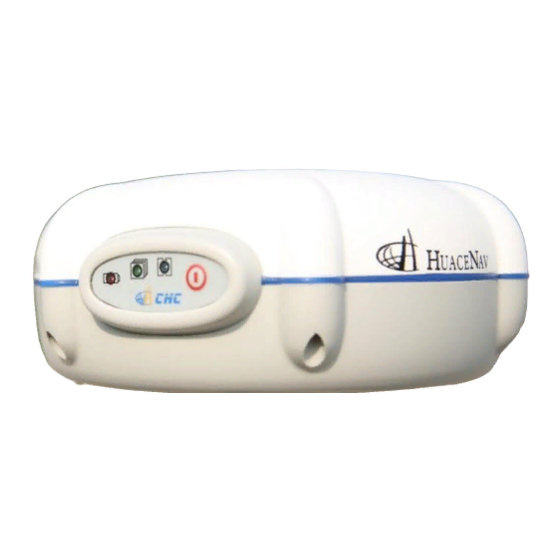
Page 12: Parts Of The Receiver (Control Panel)
To turn on X20+GPS, hold the power button pressed until the power lights up. Power LED This indicator is on when X20+GPS is on, and off when it is off. Satellite LED When you have turned on X20+GPS, the satellite LED will flash. -
Page 13: Bottom View
Preparation 3.3.2 Bottom view RS232 serial port RS232 serial port allows you to connect X20+GPS to PC through USB cable. Adaptor Connecting X20+GPS to tripod Battery Compartment Please put CHC made battery into the compartment properly and Figure3.3-2 make sure the battery away from fire. -
Page 14: Setting Up The Receiver As Static
Setting up the Receiver as Static 4. Setting up the Receiver as Static Prerequisites: You need a tripod to install the base. Put receiver on the control point and then do leveling off and centering. X20+ is not RTK base, it used in Static and post processing. Note: Mount the different items as shown on the picture. -
Page 15: Configuration
5. Configuration 5.1 Static configuration First, connect X20+GPS to your computer through RS232 cable, then run the software HC-loader. Click link icon to make the receiver connected with computer and then click setup icon to set the sample interval and mask degree of the receiver, make sure Data... -
Page 16: Nmea 0183 Output Configuration
5.2 NMEA 0183 output configuration First, connect X20+GPS to your computer through RS232 cable, then run the software HC-loader. Click link icon to make the receiver connected with computer and then click setup icon to set the sample interval and mask degree of the receiver, make sure Data Log-Manual and Port Configuration-NMEA0183 Format, then switch the receiver off after you click Apply. - Page 17 5.3 PPK configuration-Base Part and Rover Part Base part First, connect X20+GPS to your computer through RS232 cable, then run the software HC-loader. Click link icon to make the receiver connected with computer and then click setup icon to set the...
- Page 18 Rover Part First, connect X20+GPS to your computer through RS232 cable, then run the software HC-loader. Click link icon to make the receiver connected with computer and then click setup icon to set the sample interval and mask degree of the receiver, make sure Data...
- Page 19 6. Download static data from X20+ receiver 1. Switch on X20+ and connect X20+ with PC by USB cable. After a while, you will see Removable Disk appear on your PC. 2. Double click Removable Disk and you will see Folder 201209017(this folder and its date are created by X20+ automatically, its date is decide by the GPS time when you start to do static rather than your local time.
-
Page 20: Ppk Surveying
Launch the HCDiff to carry out Surveying Project 7.1 Installation of the CHC PPK Software in PDA CHC PPK software is installed in CAB format. Copy the installation file to PDA and double click the file, then the software will install automatically. -
Page 21: Launch The Hcdiff To Carry Out Surveying Project
7.2 Launch the HCDiff to carry out Surveying Project 7.2.1 Establish Bluetooth Connection with X20+ GPS Double click the HCDiff and open the main software. Go to File->New to key in the Job name and Time Zone. Tap set->Com configuration. Please select the connection type and GPS type. -
Page 22: Carrying Out Ppk Surveying
7.2.2 Carrying out PPK surveying Tap set->Init setup; please do setting the PPK surveying. Setting Int.time(s) Col.time PntFlagFreq(s) Explain The initialize The time of The point flag frequency time surveying when surveying point time Also you can define the environment of survey by tapping Set->Quality control setup. - Page 23 Line collect: tap line collect to start the line collecting. Tap line collect again to finish the Line collecting. The PtFlag is the points on the line Figure7.2-5 X20+ GPS – 1.01 Rev A – September 2010...
-
Page 24: Post Process The Ppk Data In Cgo
7.2.3 Post process the PPK data in CGO For Post Process PPK data, please refer to CGO user guide. Last review by Johnny 29 Aug 2013 More qustions please send email to support@chcnav.com, or add skpye to get online support: Skpye ID: chc_support X20+ GPS –...
Need help?
Do you have a question about the X20+GPS and is the answer not in the manual?
Questions and answers