Sign In
Upload
Manuals
Brands
BENDIXKing Manuals
GPS
AV8OR ACE
BENDIXKing AV8OR ACE Navigation System Manuals
Manuals and User Guides for BENDIXKing AV8OR ACE Navigation System. We have
2
BENDIXKing AV8OR ACE Navigation System manuals available for free PDF download: User Manual
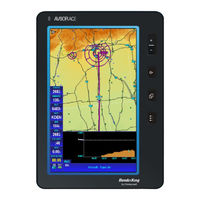
BENDIXKing AV8OR ACE User Manual (419 pages)
Brand:
BENDIXKing
| Category:
GPS
| Size: 6 MB
Table of Contents
Honeywell Customer Support
7
Honeywell Aerospace Technical Publications
8
Table of Contents
11
1 Getting Started
29
Introduction
29
Figure 1-1: on the Ground
29
Figure 1-2: in the Air
29
Unit Overview
30
Figure 1-4: AV8OR ACE Controls
30
Displays and Controls
31
Table 1-1 Displays and Controls
31
Supplied Software and Equipment
34
Charging the Internal Battery
35
Optional Equipment
35
Table 1-3 Optional Equipment
35
Using AV8OR Ace
36
Understanding Terms
36
Table 1-4: Battery Charge Level
36
Turning AV8OR ACE On/Off
37
Figure 1-5: AV8OR ACE Power up
37
AV8OR ACE Sleep Mode
38
Figure 1-6: AV8OR ACE Power off
38
Figure 1-7: AV8OR ACE Sleep Mode
38
Turn Sleep Mode on and off
38
Main Menu
39
Figure 1-8: Main Menu
39
Getting Satellite Signals
40
Figure 1-9: Settings Page
40
View GPS Status from Settings
40
Current Position
41
Figure 1-10: GPS Signal Strength Page - Locked and Unlocked
41
GPS Signal Strength
41
Figure 1-11: GPS Information of Current Position
42
Figure 1-12: GPS Data Flow
42
GPS Data Flow
42
Figure 1-13: GPS Reset
43
Satellite Acquisition Reset
43
2 Aviation Mode Operation
45
Basic Operation
45
Program Startup
45
Figure 2-1: Initial Title Page
45
Figure 2-2: Self Test Failed
46
Figure 2-3: Self Test Failed Caution
46
Figure 2-4: SELF TEST COMPLETED Page
47
Figure 2-5: Final Title Page
47
Demo Mode
48
Aviation Main Menu Page
49
Figure 2-6: Demo Mode
49
Figure 2-7: Map Page
49
Figure 2-8: Main Menu Page
50
Figure 2-9: Flight Plan - Flight Plan Index Page
51
Figure 2-10: Panel - Panel Page
51
Figure 2-11: Messages - Messages Info Page
52
Figure 2-12: Weather - Weather Map Page
53
Figure 2-13: Traffic Main Page
54
Figure 2-14: System Setup - System Setup Menu Page
54
Portrait or Landscape Mode
55
Figure 2-15: Map Page - Portrait Mode
55
VFR Moving Map Function
56
Map Display Window
56
Figure 2-16: Map Display
57
Map Page Controls and Indications
58
Fast Access
60
Figure 2-17: Fast Access
60
Image Overlays
61
Table 2-1: Image Overlays on Primary Maps
62
Figure 2-18: Topo on Map - Overlay Setup
64
Map Page Pointer/Non-Pointer
64
Figure 2-19: Map - Non-Pointer Map Mode
65
Figure 2-20: Map - Pointer Map Mode
65
Data Fields
66
Figure 2-21: Map - Pointer Tag Window / Title Window
66
Figure 2-22: Map - Without Soft Keys
66
Table 2-2 Course Deviation Limits
67
Table 2-3 Calculated Time en Route
69
Not Shown Data Field
71
Table 2-4 Time Zones
72
Figure 2-23: Map - Map View Setup
76
Map View
76
Map Zooming
76
VFR Moving Map Operation
76
Figure 2-24: Map - Smart Profile on
77
Smart Profile
77
Auto Zoom
78
Figure 2-25: Smart Profile - Airspace Vertical Boundaries
78
Figure 2-26: Auto Zoom Mode
78
Change View
79
Figure 2-27: Auto Zoom Suspended
79
Figure 2-28: Map Type Selection Screen
80
Figure 2-29: Map - Topo off
80
Figure 2-30: Map - Relative Terrain
81
Table 2-5 Relative Terrain
81
Figure 2-31: High Altitude IFR Enroute Chart
83
Figure 2-32: Low Altitude IFR Enroute Chart
84
Figure 2-33: Map - VFR Sectional Chart
85
Airports
86
Rnwys Tab
86
Figure 2-34: Airport - more INFO
86
SELECT RUNWAY Soft Key
87
Figure 2-35: Airport - Rnwys Page
87
Figure 2-36: Airports - Extended Centerline on Map Page
88
CHARTS Soft Key
89
Figure 2-37: Airports - Deselect Runway
89
Airport Information Window
90
Figure 2-38: CHARTS Soft Key
90
Figure 2-39: Charts/Procedure Page
90
Comms Tab
91
Fuel Tab
91
Figure 2-40: Airport - Comms Page
91
Figure 2-41: Airport - Fuel Page
92
Svcs Tab
93
Figure 2-42: Nearby Fuel Price Comparison
93
Local Tab
94
Figure 2-43: Airport - Svcs Page
94
NEAREST - Select Nearest Destination
95
Figure 2-44: Airport - Local Page
95
Figure 2-45: Map - Nearest Database Selection
96
Nearest Airports
96
Figure 2-46: Nearest Airports
97
Figure 2-47: Map - Airport Filter
98
Nearest Vors
98
Figure 2-48: Nearest Vors
99
Nearest User Wpts
99
Figure 2-49: Nearest User Waypoints
100
Nearest Towns and Cities
100
Waypoint Alert
101
Figure 2-50: Nearest Towns and Cities
101
Turn Anticipation
102
Figure 2-51: Waypoint Alert
102
DIRECT-TO Navigation
103
Create a Direct-To Course from the Map
103
Figure 2-52: Turn Anticipation
103
Create a Direct-To Course from the Keyboard Entry (no Flight Plan)
104
Figure 2-53: Map - Navigate to a NAVAID Point
104
Figure 2-54: Map - Virtual Keyboard
105
Re-Center Aircraft When Direct-To Is Already Enabled
106
Figure 2-55: Map - Entered Direct-To Info
106
Bypass a WPT with a Flight Plan Active
107
Enter a Direct-To WPT with a Flight Plan Active
108
Figure 2-60: Enter New WPT - Flight Plan Active - Step 2
109
Ptr Menu
110
Create a User Waypoint
110
Figure 2-61: Enter a New WPT - Flight Plan Active - Step 6
110
Figure 2-62: Map -PTR MENU - Save Waypoint
111
Figure 2-63: Map - User Defined Waypoint
111
Center the Map Around Pointer Position
112
Figure 2-64: MAP - User Defined Waypoint - more INFO
112
PTR MENU - DIRECT-TO Navigation
113
To Select a User Defined Point on the Map
113
PTR MENU - OBS Navigation
113
To Select a NAVAID Point on the Map
113
Figure 2-65: Map Centered on Pointer
113
To Select a User Defined Point on the Map
114
Figure 2-66: OBS Course to NAVAID
114
Figure 2-67: OBS Course Correction Keypad
114
Center Map
115
Figure 2-68: OBS - New Course Entered on Keypad
115
Center to Wpt/Center Aircraft
116
Figure 2-69: Map - Center to Waypoint
116
Selectable GPS Data Source
117
Autonav
117
Figure 2-70: Map - Center to Aircraft
117
Stop Watch
119
Flight Plan Function
120
User Waypoints
120
Figure 2-71: Flight Plan Index Page
120
Figure 2-72: Flight Plan - User Waypoint List
121
Figure 2-73: Flight Plan - New/Edit User Waypoint
121
Figure 2-74: Flight Plan - WPT Range and Bearing Config
122
User Waypoint Icons
122
Figure 2-75: Select User Waypoint Icon
123
User Airport Entry
123
Figure 2-76: User Airport Entry
124
Figure 2-77: User Airport Entry
124
Creating New Flight Plan Using the Virtual Keyboard
125
Figure 2-78: Flight Plan - Index Page with no Flight Plan
125
Figure 2-79: New Flight Plan Page
126
Figure 2-80: Enter Waypoint Identifier
126
Figure 2-81: Waypoint Entry Window
127
Inserting Victor Airways into the Flight Plan
128
Figure 2-82: All Wpts Entered into Flight Plan
128
Figure 2-83: Flight Plan Saved
128
Figure 2-84: Stored Flight Plan
129
Figure 2-85: Select Airway Segment
130
Figure 2-86: Select Entry and Exit Points
130
Smart Airways
131
Figure 2-87: Updated Flight Plan with Victor Airway
131
Figure 2-88: Smart Airways Entry Screen
132
Figure 2-89: Smart Airways - Segment Details
132
Creating New Flight Plan Using MAP Selections
133
Figure 2-90: Flight Plan - Map Selection of Wpts
133
Figure 2-91: Flight Plan - Waypoint Detail
134
Figure 2-92: Flight Plan - Selected Waypoint Detail Information
134
Figure 2-93: Flight Plan - Stored Flight Plan with a Waypoint
135
Figure 2-94: Flight Plan - Save Waypoint
135
Stored Flight Plans Processing
136
Figure 2-95: Flight Plan - Flight Plan Accepted
136
DATA VIEW Mode
137
Edit a Flight Plan
137
Figure 2-96: Flight Plan Index Page
137
Figure 2-97: Flight Plan - DATA VIEW
138
MAP VIEW Mode
138
Figure 2-98: Flight Plan Selected WPT from Map
139
Figure 2-99: Flight Plan - FPLAN ADMIN
139
Flight Plan Administration
139
COPY a Flight Plan
140
Figure 2-100: Flight Plan - COPY FPLAN
140
Invert a Flight Plan
140
New Flight Plan
140
Delete a Flight Plan
142
Figure 2-104: Delete Flight Plan
142
Figure 2-105: Flight Plan - FLY FPLAN
143
Fly a Flight Plan
143
Active Flight Plan
144
Figure 2-106: Flight Plan - Active Flight Plan
144
Top of Descent Function
144
Descent Profile Entry Window
145
Figure 2-107: Top of Descent Window
145
Figure 2-108: Top of Descent Overhead View
146
Figure 2-109: Top of Descent Profile View
146
Charts and Procedures
148
Figure 2-110: Charts/Procedure Page
149
Selected Airport
149
Approach Chart Page
150
Figure 2-111: Charts - Airport Selection Window
150
Figure 2-112: Approach Chart Page
151
Table 2-6: Approach Chart Page
151
Airport Diagram Page
152
Figure 2-113: Airport Chart Page
152
Table 2-7: Airport Chart Page
153
Figure 2-114: SID Chart Page
154
SID Chart Page
154
Table 2-8: SID Chart Page
154
STAR Chart Page
155
Figure 2-115: STAR Chart Page
156
Table 2-9: STAR Chart Page
156
Flight Logging
158
Text Format (Bendix/King) Flight Log
158
Google Earth© Flight Log
159
Jeppesen Flitestar© Flight Log
159
Memory Map Flight Log
160
Weather Function
161
Hardware Accessory
161
Receiving Weather Data
161
Figure 2-116: WX - no Data Received
163
Figure 2-117: WX - Initial Page
163
XM Weather Information Products
163
Figure 2-118: WX - Choose Product
164
Figure 2-119: WX - NEXRAD - Composite Reflectivity
165
NEXRAD Composite Reflectivity (USA and Canada)
165
Figure 2-120: WX - NEXRAD Legend
166
Figure 2-121: WX NEXRAD Map - Overlay Setup
166
Figure 2-122: WX - NEXRAD & Storm Cells Overlay
167
Graphical Metars (USA and Canada)
167
Figure 2-123: WX - Graphical Metars
168
Figure 2-124: WX: - Graphical Metars Data Box
169
Figure 2-125: WX: - Text Metars Page
169
Figure 2-126: WX - Graphical Pireps
170
Graphical Pireps (USA Only)
170
Figure 2-127: WX - Graphical Pireps Popup Window
171
Figure 2-128: WX - Graphical Pireps Legend
171
Figure 2-129: WX - Text Pireps
172
Graphical Airmets (USA Only)
172
Figure 2-130: WX - Airmets
173
Table 2-10 Graphical AIRMET Types
173
Figure 2-131: WX - Graphical AIRMET Popup Window
174
Figure 2-132: WX: - Graphical AIRMET LEGEND
174
Figure 2-133: WX - Text AIRMET Page
175
Figure 2-134: WX - Graphical Sigmets
175
Graphical Sigmets (USA Only)
175
Figure 2-135: WX - Graphical SIGMET Popup Window
176
Figure 2-136: WX - Graphical SIGMET Legend
176
Figure 2-137: WX - Text Sigmets
176
Figure 2-138: WX - Graphical Conv Sigmets
177
Graphical Conv-Sigmets (USA Only)
177
Figure 2-139: WX - Graphical CONV SIGMET Popup
178
Figure 2-140: WX - Graphical Conv SIGMET Legend
178
Figure 2-141: WX - Text CONV Sigmets Page
179
Graphical Winds Aloft (USA Only)
179
Figure 2-142: Graphical Winds Aloft
180
Figure 2-143: Graphical Winds Aloft - Speed and Direction
181
Figure 2-144: Winds Aloft Legend
181
Select Flight Level
181
Winds Aloft Legend
181
Figure 2-145: Select Flight Level
182
Graphical Freezing Level
182
Figure 2-146: Graphical Freezing Level
183
Figure 2-147: Graphical Freezing Level - Pointer Tag Window
184
Figure 2-148: Freezing Level Legend
184
Freezing Level Legend
184
Figure 2-149: WX - Text Metars
185
Text Metars (USA and Canada)
185
Figure 2-150: WX - Text Tafs
186
Text Tafs (USA and Canada)
186
Figure 2-151: WX -Text Pireps
187
Text Pireps (USA Only)
187
Figure 2-152: Text Airmets
188
Text Airmets (USA Only)
188
Figure 2-153: Text Sigmets
189
Text Sigmets (USA Only)
189
Figure 2-154: Text Conv-Sigmets
190
Text Conv-Sigmets (USA Only)
190
Figure 2-155: WX - Pointer Mode
191
Legend
191
XM Overlays
192
Figure 2-156: WX - Legend Info
192
Figure 2-157: Topo on Map - Overlay Setup
193
Graphical Metar Overlays
193
Figure 2-158: Graphical Metar Overlay on Map Page
194
Graphical TFR Overlays
194
Figure 2-159: TFR Overlay
195
Figure 2-160: TFR Overlay - Popup
195
Figure 2-161: TFR Overlay - more INFO
196
Figure 2-162: Lightning Strikes on Map Page
196
Lightning Overlays
196
Cloud Top Overlay
197
Figure 2-163: Cloud Top Overlay on Nexrad Page
197
Storm Cell Overlay
197
Figure 2-164: WX -Storm Cells Overlay on Nexrad Page
198
Traffic Function
199
Hardware Accessory
199
Traffic Main Page
200
Figure 2-165: Traffic Main Page
200
Fields on the Traffic Page
201
Traffic Setup
201
Enable/Disable Pop-UP
202
Figure 2-166: Traffic Page - Traffic Setup
202
Flight Level
202
Figure 2-167: Traffic Page - Enable Pop-Up
203
Figure 2-168: Traffic Page - Disable Pop-Up
204
Panel Function
205
Panel Page
205
Controls
205
Figure 2-169: Panel Page
205
Compass Rose
206
Figure 2-170: Panel Page: with Data Windows
206
Rate of Turn
206
Panel Page ACE Portrait Orientation
207
Figure 2-171: Panel Page - Portrait Orientation
208
Auxillary Function
209
Messages Page
209
Figure 2-172: Messages
209
Table 2-11 Messages
210
Messages Soft Keys
212
Checklist
212
Figure 2-173: Checklist Page
214
Figure 2-174: Checklist Page
214
Wind Vector Calculator Page
215
Figure 2-175: Wind Vector Calculation Page
215
Weight and Balance Page
216
Figure 2-176: Enter Magnetic Heading
216
Figure 2-177: Weight and Balance Opening Page
216
C.G. Graph
217
Data Entry
217
Envelope
217
Figure 2-178: W&B Data Entry Page with Profile and Envelope Tabs Filled out
217
Layout
217
Profile
217
Figure 2-179: W&B - FILE Options Page
218
C.G. Graph
219
Figure 2-180: W&B COG Graph with Profile and Envelope Tabs Filled out
219
Figure 2-181: W&B - Aircraft Loaded Beyond C.G. Limits
219
Figure 2-182: W&B Layout Page with Profile and Envelope Tabs Filled out
220
Figure 2-183: W&B Profile Page
221
Figure 2-184: W&B Envelope Page
222
Creating a New Weight and Balance Profile
223
System Setup Function
225
System Setup Menu
225
Figure 2-185: System Setup - System Setup Menu Page
225
General System Setup
226
Figure 2-186: System Setup - General System Setup Options
226
Figure 2-187: System Setup - Setting Values
227
Map Setup
229
Figure 2-188: Map System Setup Options
229
Figure 2-189: Map System Setup -- Select Map Layer
231
Figure 2-190: Map System Setup - Point Feature Setup
232
Figure 2-191: Map System Setup - Line Feature Setup
232
Figure 2-192: Map System Setup - Airspace Setup
233
Navigation Setup
234
Data Field Setup
238
Figure 2-195: Data Field Setup
238
Flight Plan Data Setup
240
Figure 2-196: Data Field Setup - Wide Windows
240
Demo Mode Setup
241
Figure 2-197: Flight Plan Data Setup
241
Figure 2-198: Demo Mode Setup
242
Figure 2-199: Demo Mode Ident Settings
242
Figure 2-200: Demo Mode Setup Ident Details
243
Figure 2-201: Device Setup Menu
244
Status Page
245
Figure 2-202: System Setup - Status Page
246
Figure 2-203: Status Page Setup - Internal GPS Status
247
Figure 2-204: Status Page Setup - External GPS Status
247
Figure 2-205: Status Page Setup - Map Information Page
248
Figure 2-206: Status Page Setup - Software and DB Version
249
Figure 2-207: Status Page Setup - System Information Page
250
Figure 2-208: Status Page Setup - Traffic Status Page
250
Figure 2-209: Status Page Setup - Weather Status Page
250
Refresh Mode
252
Figure 2-210: NMEA Output Setup Page
253
Device Setup Page
254
NMEA Output Setup
254
NMEA Output Setup Options
254
Transmit Default NMEA Sentences
254
Transmit Selected NEMA Sentences
254
Figure 2-211: Exit Go Fly Warning Screen
256
Shut down
256
Figure 2-212: Go Fly Exit Screen
257
3 Automotive Mode Operation
259
Warnings and Safety Information
259
Map Updates
259
Glossary
260
Getting Started
262
Figure 3-1: AV8OR ACE Main Menu
262
Figure 3-2: Simple Mode
263
Figure 3-3: Advanced Mode
263
Simple and Advanced Modes
264
Table 3-1: Simple Versus Advanced Mode
264
Soft Keys and Controls on the Screen
266
Using Keyboards
268
Additional Controls
269
Using the Map
270
Checking the Details of a Map Location
271
Figure 3-4: Map Screen
271
Manipulating the Map
272
Status Information and Hidden Controls on the Map
274
Using the Cursor (the Selected Map Location)
280
Advanced Functions
281
Smart Zoom
281
Current GPS Position and Lock-On-Road
282
Position Markers
282
Returning to Normal Navigation
282
Original Position in the Cursor Menu
283
Selected Location (Cursor)
283
Color Scheme in Tunnels
284
Daytime and Night Color Schemes
284
Route Calculation and Recalculation
284
Figure 3-5: Itinerary
285
Itinerary
285
POI (Points of Interest)
287
Route Demonstration
287
Track Logs
287
Managing POI
288
Road Safety Cameras
288
Saving POI
288
Camera Types
289
Camera Warning
289
Saving Road Safety Cameras
289
Camera Directions
291
Speed Limit Warning
292
TMC (Traffic Message Channel)
292
Advanced Features in Godrive Version 8.3
293
ROUTE Navigation
294
Selecting the Destination of a Route
294
Figure 3-6: Guidance Stripes
294
Figure 3-7: Highway Signposts
294
Selecting the Cursor as the Destination
295
Entering an Address (Europe)
296
Entering an Address or Part of an Address
296
Figure 3-8: Enter an Address (Europe)
296
Entering an Address (North America, Australia)
298
Figure 3-9: Find an Address - USA
298
Entering an Address if House Numbering Is Restarted
300
Enter an Address Without Knowing the District/Suburb
302
Selecting an Intersection as the Destination
303
Selecting a City Center as the Destination
305
Entering an Address with a Postal Code
306
Tips on Entering Addresses Quickly
307
Selecting the Destination from the Pois
308
Selecting the Destination from Your Favorites
308
Selecting the Destination with Saved POI Search Criteria
310
Selecting the Destination by Entering Its Coordinate
311
Selecting the Destination from the History
311
Creating a Multi-Point Route (Inserting a Via Point)
312
Creating a Multi-Point Route (Append a New Destination)
313
Editing the Route
314
Viewing Whole Route on the Map (Fit to Screen)
315
Watching the Simulation of the Route
316
Enabling Safety Mode
316
Pausing the Active Route
317
Deleting the Next Via Point from the Route
317
Deleting the Active Route
317
Using Track Logs
318
Recording the Travelled Path (Creating a Track Log)
318
Simulating a Track Log on the Map
318
Changing the Color of a Track Log
319
Saving a Route
319
Loading a Saved Route
320
Reference Book (Advanced Mode)
321
Map Screen
322
Figure 3-10: Map Screen Advanced Mode
322
Icons on the Map
326
Battery, GPS Position Quality, Vehicle Type Indicator
327
Status Indicator Strip
328
Next Two Route Events (Turn Preview Fields)
329
Objects on the Map
331
Detour Menu
333
Streets and Roads
333
Cursor Menu
334
Position Menu
337
Route Information Screen
337
Figure 3-11: Route Information Screen
338
Trip Information Screen
340
Figure 3-12: Trip Information Screen
341
Trip Computer Screen
344
Quick Menu
345
Figure 3-13: Quick Menu
346
Figure 3-14: GPS Status
348
GPS Data Screen
348
Find Menu
351
Route Menu
352
Manage Menu
353
Manage History
354
Manage Saved Routes
354
Manage Track Logs
354
Manage Favorites
356
Manage Pois
356
Manage Saved Search Criteria
358
User Data Management
359
Figure 3-15 Settings Menu
360
Settings Menu
360
Map Screen Settings
362
Sound Settings
362
Route Planning Options
363
Regional Settings
366
Navigation Settings
368
Warning Settings
369
GPS Settings
371
Menu Settings
371
Device Settings
372
Track Log Settings
373
4 Multimedia
375
Music Player
375
Figure 4-1: Multimedia Menu
375
Photos
376
Figure 4-2: Music Player - Searching for a Music File
376
Figure 4-3: Music Player - Playing Music
376
Figure 4-4: Photo Browser - Searching for a Photo
377
Movie Player
378
Figure 4-5: Photo Browser - Viewing a Photo
378
Ebook Reader
379
Figure 4-6: Movie Player - Searching for a Movie
379
Figure 4-7: Movie Player - Playing a Movie
379
Figure 4-8: Ebook Reader - Searching for a Book
380
Figure 4-9: Ebook Reader
380
XM Tuner
381
XM Weather and Radio Setup
381
Figure 4-10: XM Radio Page
381
Figure 4-11: XM Status Page
382
XM Radio Tuning
383
Figure 4-12: XM Categories Page
383
Downloading Multimedia Files
384
System Settings
385
GPS Status
385
Backlight
385
Figure 5-1: Settings Page
385
Backlight Control Bar
386
Backlight Shutdown Setting
386
Volume
386
Figure 5-2: Backlight Page
386
Enable/Disable Audio Output
387
Figure 5-3: Volume Control
387
Volume Control Bar
387
System Info
388
Bluetooth
388
Figure 5-4: System Info Screen
388
Figure 5-5: Bluetooth Manager Page
388
Figure 5-6: Bluetooth - Add Device Page
389
Figure 5-7: Bluetooth - Pair Device Page
390
Figure 5-8: Bluetooth - Passkey Requested Page
391
Figure 5-9: Bluetooth - Service Providers Page
391
Service Providers Page
391
DUN Favorite Provider Selection Page
392
DUN Setup Page
392
Figure 5-10: Bluetooth - DUN Setup Page
392
Figure 5-11: Bluetooth - DUN Favorite Provider Page
393
Initial Setup
393
Figure 5-12: Initial Setup Menu Page
394
6 Appendix
395
Acronyms and Abbreviations
395
Downloading/Uploading Files From/To PC
399
Figure 6-1: Connection to USB Port
399
Figure 6-2: Configure AV8OR ACE as External Drive
400
Table 6-1 Directory Structure
400
Mini Usb/Serial Port
403
Table 6-2: Mini USB Connections
403
Connection to an External GPS Source
404
Bendix/King KLN-94
404
Garmin© GNS 430/430W/530/530W
404
Figure 6-3: External GPS Setup Screen
405
Table 6-3 KLN 94 Pinouts
405
Table 6-4 GNS 430/430W/530/530W Pinouts
405
Connection to an External Weather Source
406
Bendix/King KDR-610 Setup
406
Figure 6-4: Weather Setup - KDR-610
406
Table 6-5 KDR 610 Pinouts
407
Wxworx XM Weather Receiver Serial Setup
408
Figure 6-5: Wxworx XM Weather Setup
408
Wxworx XM Weather Receiver Bluetooth Setup
409
Figure 6-6: Wxworx Bluetooth Receiver Setup
409
Figure 6-7: Bluetooth Manager Page
410
Figure 6-8: Add Bluetooth Device
411
Figure 6-9: Bluetooth - Pair Device
411
Figure 6-10: Bluetooth Passkey Required
412
Figure 6-11: Bluetooth Connecting
412
Figure 6-12: Bluetooth Wxworx Connection Established
413
Connection to an External Traffic Source
414
Zaon XRX - Serial Setup
414
Configuration of AV8OR
414
Configuration of the Zaon XRX
414
Zaon XRX - Bluetooth Setup
415
Figure 6-13: Device Setup Page - Traffic
415
External Flight Plans
416
Jeppesen Flitestar© PC Application
416
Subscriptions and Updates
417
Bendix/King Subscriptions
417
Figure 6-14: Navigation Data Subscription Coverage
417
Gofly Fuel Pricing and Airport Services
417
Gofly Navigation Data Subscriptions
417
Other Subscriptions
418
FAA Chart Data
418
Godrive Automotive Maps
418
Gofly XM Weather
418
Figure 6-15: AV8OR Ace Upgrade Screen
419
Updates
419
Advertisement
BENDIXKing AV8OR ACE User Manual (2 pages)
Basic Operation
Brand:
BENDIXKing
| Category:
Monitor
| Size: 0 MB
Table of Contents
User Manual
1
Basic Operation
1
Multimedia Features
2
Settings and Configuration
2
FCC Statement
2
Advertisement
Related Products
BENDIXKing AV8OR
BENDIXKing AV80R
BENDIXKing AeroPower
BENDIXKing AeroNav 800 FMS/GPS/NAV/COM
BENDIXKing AeroNav 780 FMS/GPS
BENDIXKing AeroNav 905
BENDIXKing AeroNav 910
BENDIXKing KLN 90B
BENDIXKing KLN 94
BENDIXKing KLX 135A
BENDIXKing Categories
GPS
Transceiver
Avionics Display
Autopilot System
Monitor
More BENDIXKing Manuals
Login
Sign In
OR
Sign in with Facebook
Sign in with Google
Upload manual
Upload from disk
Upload from URL