Sign In
Upload
Manuals
Brands
BENDIXKing Manuals
Car Navigation system
AeroNav 800 FMS/GPS/NAV/COM
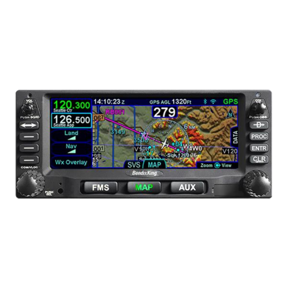
BENDIXKing AeroNav 800 FMS/GPS/NAV/COM Manuals
Manuals and User Guides for BENDIXKing AeroNav 800 FMS/GPS/NAV/COM. We have
1
BENDIXKing AeroNav 800 FMS/GPS/NAV/COM manual available for free PDF download: Pilot's Manual
BENDIXKing AeroNav 800 FMS/GPS/NAV/COM Pilot's Manual (374 pages)
Brand:
BENDIXKing
| Category:
Car Navigation system
| Size: 9 MB
Table of Contents
Table of Contents
5
1 System Overview
11
Intended Function
12
Aeronav 780
13
Functional Overview
14
Basic Concepts
16
Page Function Keys
16
Line Select Keys
16
Right Knob Labeling
17
Color Philosophy
17
General Aeronav Operations
19
Aeronav 800 Bezel Layout
19
Aeronav 780 Bezel Layout
20
Power Control
22
Brightness Controls
23
Start-Up Sequence
24
Database Currency States
27
Page Layout and Formats
29
Com-Nav
31
Frequency List
37
Transponder Control and Display
38
Direct-To Operations
41
Function Keys
43
Touch Screen
45
Use of External Keyboard
49
Dual Aeronav Operations
50
Wifi (Network) Operations
55
WAAS Vs Non-WAAS Operations
58
Interaction with External Devices
59
Before Takeoff Techniques
60
2 FMS Subsystem
61
Fpl (Flight Plan) Tab
62
FMS Basic Concepts
62
Creating a New Flight Plan
64
Previewing Flight Plans
66
Selecting a Departure
68
Inserting a Waypoint
70
Inserting an Airway
71
Deleting a Waypoint
72
Editing a Waypoint
73
Adding Altitude Constraints
73
Entering and Intercepting a Radial
74
Deleting a Flight Plan
76
Creating a Holding Pattern
76
Circular Orbits
78
Deleting a Holding Pattern
79
Editing a Holding Pattern
80
Activating a Flight Plan
80
Flight Plan Sequencing
80
Lateral Offsets
81
Flight Plan Discontinuities (Gaps)
82
Enroute Descents
83
Entering an Arrival and Approach
86
Activating a Leg
90
Use of the Map FPL Split Page
90
Info Tab
92
Route Tab
96
Creating a New Route
97
Editing a Route
97
Naming a Route
97
Copying a Route
98
Inverting a Route
99
Activating a Route
100
Deleting a Route
100
Wpt (User Waypoints) Tab
102
Creating a User Waypoint
102
Naming a User Waypoint
103
Deleting a User Waypoint
103
Designating a User Waypoint as an Airfield
103
Nrst (Nearest) Tab
105
3 Map Subsystem
109
Map Tab
110
Map Controls
110
Other Map Features
113
Fuel Range Rings
118
Decluttering the Map
119
Map Panning
120
Graphical Flight Planning ("Rubber Banding")
121
Altitude Constraints on Map
122
Map Information Pop-Up Boxes
123
Datalink Weather Overlays and Operations
125
Datalink Radar
126
Weather Overlays on Map
128
Tfrs
132
Indications of Data Age
133
Weather Radar Selection for Map Overlay
134
Terrain
135
Terrain Awareness (Ta)
136
Forward Looking Terrain Alerting (FLTA)
137
500' Callout
140
Terrain Alerting Warning System (Taws)
141
Premature Descent Alert (PDA)
144
Excessive Descent Rate (EDR)
145
Negative Climb Rate / Altitude Lost after Takeoff
146
TAWS Inhibit Control
148
TAWS Self-Test
148
Degraded or no TAWS Conditions
148
Traffic Display
149
Synthetic Vision (Svs) Tab
158
Radar Tab
163
4 Aux Subsystem
171
Audio Tab
172
Volume Control
172
Satellite Radio Tuning
174
Com Presets
176
Util (Utilities) Tab
178
Timers
178
Calculators
181
Electronic Checklist
185
Setup Tab
189
Datablock Setup
189
Map Setup
209
FMS Setup
210
User Options
210
Sys (System) Tab
233
Fuel Management
233
System Status
233
Alert Tab
244
5 Navigation
245
Nav Source Knob/Button
250
Obs Mode
254
Vor Course Depiction
257
Armed Vs Engaged/Active Indications
258
Fms Hooks
259
Course Changes and Holds
262
Auto Vloc Tuning
263
Transition Altitudes/Levels
264
Navigation Mode/CDI Scale Changing
266
Approach Procedures
268
Automatic Mode Switching
269
Precision Approaches
270
Non-Precision Approaches
271
Back Course Approaches
271
WAAS Approaches
272
Missed Approach
276
Retry Approach
279
Rnp/Rnav Operations
281
Recommended Icao Equipment Codes
282
6 General
283
Caution Advisory System (Cas) / Alerts
284
Master Caution Lamps
284
Warning-Caution-Advisory Message Bar
285
Self Test Output
308
System Failures
309
Power Distribution
309
Loss of Aeronav
309
Loss of Display
310
Loss of Bezel Controls
311
Loss of Touchscreen Control
311
Loss of GPS (Dead Reckoning)
312
Other Anomalies
313
Subscriptions
314
Night Operations
315
Aeronav DISPLAY BRIGHTNESS
315
Aeronav Bezel Brightness
315
Charts Lighting Scheme
315
Display of Terrain on Map
316
High Temperature Operations
317
Cold Temperature Operations
318
Low Power Operations
319
High Power Operations
321
Use of Gloves
322
Charging from the Usb
324
Integration with the Ifd100 Mobile App
325
Demo Mode
326
Data Transfer To/From External Devices
329
Regulatory Compliance Statements
333
Radio Regulatory Compliance Statements
333
Déclaration(S) de Conformité Réglementaire
334
Maintenance Mode
335
Starting Maintenance Mode at Power up
335
Starting Maintenance Mode from Flight Mode
335
Exiting Maintenance Mode
337
Database Updates
338
Software Updates
345
Datalogs Download
346
User Data Backup/Restoration Procedure
351
Saving User Data
351
Reloading Previously Stored User Data
352
Configuring Wifi
353
Defining WIFI Network Configurations
353
Selecting a Network Configuration
356
Configuring Wired Ethernet
357
Configuring as a Network Server
357
Configuring as a Network Client
357
Configuring as a Client with a Static IP
357
Pairing a Bluetooth Keyboard
359
Verification of Successful Pairing
362
Cleaning the Display
365
Slide-In Replacement Details
366
Advertisement
Advertisement
Related Products
BENDIXKing AeroNav 780 FMS/GPS
BENDIXKing AV8OR
BENDIXKing AV8OR ACE
BENDIXKing AV80R
BENDIXKing AeroPower
BENDIXKing KNS 80
BENDIXKing Categories
GPS
Transceiver
Avionics Display
Autopilot System
Monitor
More BENDIXKing Manuals
Login
Sign In
OR
Sign in with Facebook
Sign in with Google
Upload manual
Upload from disk
Upload from URL