
Subscribe to Our Youtube Channel
Related Manuals for GeoSlam ZEB-GO


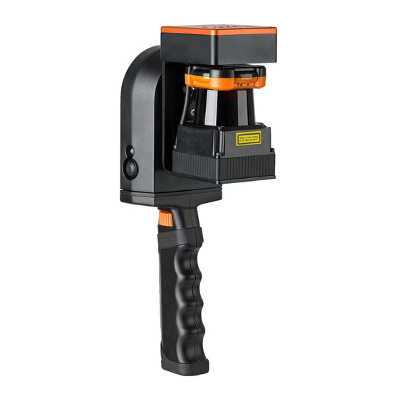
Summary of Contents for GeoSlam ZEB-GO
- Page 1 Copyright ZEB-GO™ User Guide © 2020 GeoSLAM Ltd. All rights reserved. ZEB-GO User Guide © 2021GeoSLAM ZEB‐GO User Guide v1.0.7...
- Page 2 GeoSLAM Ltd. GeoSLAM Ltd. provides this guide “as is”, without warranty of any kind and reserves the right to make improvements and/or changes to the product described in this guide at any time and without notice.
-
Page 3: Table Of Contents
Duration of scanning ................12 Survey areas with restricted or difficult access......... 12 Moving objects in the environment ............12 Data Processing ..................... 13 GeoSLAM Hub Software ................13 Battery ......................14 Specification ..................... 14 Recharging ....................14 Charge Indicator ..................14 Battery care .................... -
Page 4: Introduction
INTRODUCTION The ZEB-GO portable laser scanner provides a rapid and simple means of capturing 3D point cloud data. Data is captured as the user walks through the area of interest. The ZEB-GO negates the need for time consuming scanner set-ups and data registration associated with traditional terrestrial laser scanning methods. -
Page 5: Principal Of Operation
PRINCIPAL OF OPERATION The ZEB-GO consists of a 2D time-of-flight laser range scanner rigidly coupled to an inertial measurement unit (IMU) mounted on a motor drive. The motion of the scanning head on the motor drive provides the third dimension required to generate 3D information. A novel 3D simultaneous localization and mapping (SLAM) algorithm is used to combine the 2D laser scan data with the IMU data to generate accurate 3D point clouds. -
Page 6: Safety
Ruddington, UK for proper treatment with the objectives of the WEEE. INSTALLATION The ZEB-GO can be used as a handheld device using the supplied removable handle or can be mounted to mobile platform using the supplied mounting plate (see Section 7.2). -
Page 7: Data Capture
Connect the ZEB-GO main cable to the socket on the side of ZEB-GO scanner head. Use red dots to align correctly. Connect the other end of the ZEB-GO cable to the ZEB (white) socket on the DL2600 data logger. Use red dots to align correctly. -
Page 8: Collecting Data
COLLECTING DATA The process of collecting data using the ZEB-GO scanning system is highly automated. However, care must be taken to ensure that the collected data can be successfully processed into a 3D point cloud using GeoSLAM’s unique SLAM algorithm. It is strongly recommended that the user conducts a survey plan, taking into account the recommendations set out in the Usage Guidelines in chapter 4, before commencing data collection. -
Page 9: Downloading The Raw Scan Data
DOWNLOADING THE RAW SCAN DATA To download the raw scan data, switch on the ZEB-DL2600 data logger or leave it running after a scan is complete and the data has compressed (Step 5 above). Connect the DL2600 download cable to the AUX socket (with blue socket marker) and connect the supplied USB memory stick to the download cable. - Page 10 Red flash x 1 Error – IMU not detected Red flash x 2 Error – neither scanner nor IMU detected Red flash x 3 Table 0-1: ZEB-GO LED status summary AUX LED Description Green Copying data to USB memory stick ...
-
Page 11: Usage Guidelines
Ensure that whatever limited features are available are scanned repeatedly as you move through the environment by pointing the ZEB-GO in the direction of the feature. By doing so more measurement points are made of the feature increasing the likelihood that it will be used by the SLAM algorithm. This is particularly important when the feature is at long range (>10m). -
Page 12: Minimum And Maximum Range
MINIMUM AND MAXIMUM RANGE Data within a small range value is not processed (by default) to eliminate data from the scanner operator being included in the final point cloud. Avoid close proximity to walls and ceilings. The maximum range of the scanner is 30m. This range will only be achieved in optimal conditions (indoors with good target reflectivity). -
Page 13: Data Processing
Further instructions for data export and the other post processing options in GeoSLAM Hub are described in the separate GeoSLAM Hub User Guide. Once the data has processed, select the Export button to save the data in its preferred format, as described in the GeoSLAM Hub User Guide. -
Page 14: Battery
BATTERY SPECIFICATION Output voltage 12V nominal Capacity 4Ah or 8Ah (+/-5%) 96Wh Charge voltage 12.6V Weight 0.6kg Charging temperature C to 45 Life cycle >300 cycles Protection Over charge, over discharge and short circuit protected Transportation UN 38.3 transportation test certified Table 6-1 Battery Specification RECHARGING Plug the charger into the AC mains –... -
Page 15: Appendices
APPENDIX 1 - USB PREPARE TOOL The USB Prepare application in the Tools folder in the GeoSLAM Windows Program Group enables users to perform some basic interaction with the ZEB DL-2600 data logger. The Program Group is accessed via the Windows Start button. -
Page 16: Appendix 2 - Dimensional Drawings
APPENDIX 2 – DIMENSIONAL DRAWINGS Dimensional drawings with optional mounting plate on rear face © 2021GeoSLAM ZEB‐GO User Guide v1.0.7... - Page 17 Dimensional drawings with optional mounting plate on bottom face © 2021GeoSLAM ZEB‐GO User Guide v1.0.7...
Need help?
Do you have a question about the ZEB-GO and is the answer not in the manual?
Questions and answers