Nextar ME Software Instruction Manual
Automotive navigation system (gps)
Hide thumbs
Also See for ME:
- Instruction manual (26 pages) ,
- User manual (80 pages) ,
- Quick start manual (1 page)
Table of Contents
Advertisement
Quick Links
Advertisement
Table of Contents

Related Manuals for Nextar ME


Summary of Contents for Nextar ME
- Page 2 Nextar Navigation System right away. This document is the detailed description of the software. You can easily discover Nextar Navigation System while you are using it; however, we still recommend that you read this manual to understand the screens and the features of Nextar Navigation System.
-
Page 3: Table Of Contents
Table of contents 1 Warnings and Safety information ... 6 2 Getting started with Nextar Navigation System ... 7 2.1 Simple and Advanced modes ... 10 2.2 Buttons and other controls on the screen... 12 2.2.1 Using keyboards... 14 2.3 Using the map ... 15 2.3.1 Checking the details of a map location... - Page 4 3.1 Selecting the destination of a route ... 37 3.1.1 Selecting the Cursor as the destination... 38 3.1.2 Entering an address or part of an address ... 39 3.1.2.1 Entering an address (North America) ... 39 3.1.2.2 Entering an address if house numbering is restarted ... 41 3.1.2.3 Entering an address without knowing the district/suburb 43 3.1.2.4 Selecting an intersection as the destination...
- Page 5 4.1 Map screen... 67 4.1.1 Icons on the map ... 71 4.1.1.1 Battery, GPS position quality and Vehicle type indicator 71 4.1.1.2 Status indicator strip ... 73 4.1.1.3 Next two route events (Turn Preview fields)... 74 4.1.2 Objects on the map... 75 4.1.2.1 Streets and roads ...
- Page 6 4.5.3 Route Planning options ... 107 4.5.4 Regional settings ... 110 4.5.5 Navigation settings... 112 4.5.6 Warning settings... 113 4.5.7 GPS settings ... 115 4.5.8 Menu settings ... 115 4.5.9 Device settings ... 116 4.5.10 Track Log settings... 116 5 Glossary ... 118 6 End User Licence Agreement...
-
Page 7: Warnings And Safety Information
Nextar Navigation System recommended, Nextar Navigation System changes the instructions accordingly. Never place Nextar ME where it obstructs the driver's view, where it is in the deployment zone of an airbag or where it might cause injuries in an accident. -
Page 8: Getting Started With Nextar Navigation System
2 Getting started with Nextar Navigation System Nextar Navigation System is optimized for in-car use. You can use it easily by tapping the screen buttons and the map with your fingertips. Nextar Navigation System can plan routes throughout the whole installed map set;... - Page 9 Tasks • • • • • Gestures You do not need gestures to access the basic (drag&drop) navigation features. You need to drag and drop the screen only in cases like: • • • • Instructions Tap and hold screens: the Navigation menu appears. Tap and hold any of the , and screen: you can rotate, tilt or scale the map...
- Page 10 Tasks Start using Nextar Navigation System When Nextar Navigation System is started the first time, you need to do the following: Select the written language of the application interface. Later you can change it in Settings (page 110). Select the language and speaker used for voice guidance messages.
-
Page 11: Simple And Advanced Modes
The typical way of using Nextar Navigation System is to select a destination, and start navigating. You can select your destination in the following ways (not all of them are available in Simple mode): • Use the selected location on the map (the Cursor) (page 38). - Page 12 To switch from Simple mode to Advanced mode: on the startup screen (Navigation Menu), tap To switch from Advanced mode to Simple mode: on the startup screen (Navigation Menu), tap The features and settings available in each mode are as follows: Type of action Navigating to a selected map point...
-
Page 13: Buttons And Other Controls On The Screen
When you are using Nextar Navigation System, you usually tap buttons on the touch screen. You only need to confirm selections or changes in Nextar Navigation System if the application needs to restart, it needs to perform a major reconfiguration, or you are about to lose some of your data or settings. - Page 14 When you need to select from several options, they appear in a list. When feature several different unnamed values, Nextar Navigation System shows an indicator on a gauge that displays and sets a value from a range. How to use it Tap it once.
-
Page 15: Using Keyboards
Virtual keyboard 2.2.1 Using keyboards You only need to enter letters or numbers in Nextar Navigation System when you cannot avoid it. You can type with your fingertips on the full-screen keyboards and you can switch between various keyboard layouts, for example ABC, QWERTY, or numerical. -
Page 16: Using The Map
Entering symbols Finalising the keyboard entry 2.3 Using the map The map screen is the most frequently used screen of Nextar Navigation System. It can be accessed from the Navigation menu by tapping Details lowercase letters, initial capitals or all capitals. -
Page 17: Checking The Details Of A Map Location
For further information about the map screen, see page 67. 2.3.1 Checking the details of a map location • If you are interested in the details of your current position during navigation: Check the bottom line of the map. It shows the current street and house number information. -
Page 18: Manipulating The Map
If GPS position is available and you have moved the map, the Tap this button to return to the GPS position. Tap this button to show or hide the following map control buttons: •... - Page 19 3D mode. Changes the horizontal view angle of the map in 3D mode. When GPS position is available, Nextar Navigation System always rotates the map so its top faces your direction of travel (Track-Up orientation). You can turn away from Track-Up with these buttons.
- Page 20 • If the next turn is at a distance, Nextar Navigation System zooms out and lowers the view angle to show you the road in front of you.
- Page 21 Tap&hold any of the buttons to set its value to the current tilt and zoom levels, or to reset it to its original value. Nextar Navigation System shows the scale of the map in 2D mode. This button does not appear on the Map screen.
-
Page 22: Status Information And Hidden Controls On The Map
Some dots need to turn green to be able to navigate. GPS position and Tap this area to make an active route are Nextar Navigation System available, but recalculate the automatic off-route recommended route. recalculation is switched off, and you deviated from the route. - Page 23 Details Nextar Navigation Nothing happens if you tap System is this area of the screen. calculating or recalculating the route. Tap this area to open the GPS position and Route Information screen.
- Page 24 Icon Informati Second When GPS position route event and an active route (maneuver after the this field shows the next route maneuver) follows the next route event shown in the above described area. Stops the This running during simulation Over, Simulation, and Track Log playback.
-
Page 25: Icon Description
The following symbols appear in the Indicator strip: Icon The sound output of Nextar Navigation System is muted. The sound output of Nextar Navigation System is enabled. Nextar Navigation System records a Track log when GPS position is available. Track log recording is disabled. - Page 26 Distance remaining to reach the next via point • Current altitude More information A higher number of lit bars indicates better GPS position accuracy. The device is running on battery power. The number of lit bars represent the remaining capacity.
-
Page 27: Using The Cursor (The Selected Map Location)
Cursor menu. Action In the active route, uses the Cursor as the start point by replacing the current GPS position (available in Advanced mode only) In the active route, uses the Cursor as the destination by replacing the previous destination... -
Page 28: Nextar Navigation System Concepts
• While driving without an active route in Nextar Navigation System: Smart Zoom will zoom in if you drive slowly and zoom out when you drive at high speed. -
Page 29: Position Markers
Smart Zoom if necessary. 2.4.2 Position markers 2.4.2.1 Current GPS position and Lock-on-Road When your GPS position is available, Nextar Navigation System marks your current position with the location of the position marker depends on the vehicle type used for route calculation. -
Page 30: Returning To Normal Navigation
GPS position and re-enable Track-up map orientation (automatic map rotation). Note! Even if you move the map while you are driving, Nextar Navigation System continues navigating if there is an active route: it plays the voice instructions and displays the turn preview icons according to your current GPS position. -
Page 31: Original Position In The Cursor Menu
Cursor menu was opened, and the icon appears again. 2.4.3 Daytime and night color schemes Nextar Navigation System uses different color schemes during the day and during the night. • Daytime colors are similar to paper road maps. -
Page 32: Color Scheme In Tunnels
However, roads and streets keep their original colors from the daytime or night color scheme currently used. After leaving the tunnel, the original colors return. 2.4.5 Route calculation and recalculation Nextar Navigation System calculates the route based on your preferences: • Route calculation method: •... -
Page 33: Itinerary
• Cross-border Planning • Carpool Lanes (appears only when used in the USA) Nextar Navigation System automatically recalculates the route if you deviate from the proposed itinerary. For further information about Route Planning options, see page 107. 2.4.6 Itinerary The Itinerary is the list of the route events, that is, the driving instructions. - Page 34 • In Advanced mode, tap the following buttons: You have the following options on the Itinerary screen: Button Any of the list Opens the map with the selected maneuver in the items middle. Changes the detail level of the Itinerary. The levels are as follows: •...
-
Page 35: Track Logs
2.4.7 Track Logs Nextar Navigation System can log the track that you drive (page 62). A Track Log is a recording of how your GPS position changed and it is independent of the route Nextar Navigation System calculated. Track Logs can be recorded, renamed, replayed, shown on the map, exported to a memory card in GPX format, and deleted. -
Page 36: Poi (Points Of Interest)
2.4.9 POI (Points of Interest) A point of interest (POI) is a location that someone might find useful or interesting. Nextar Navigation System is delivered with thousands of POIs and you can also create your own POIs in the application. -
Page 37: Speed Limit Warning
(ask your local dealer) or may not be fully correct for all roads on the map. You can configure Nextar Navigation System to warn you if you exceed the current limit. Tap the following buttons: When you exceed the speed limit, the following happens: •... -
Page 38: Navigating With Nextar Navigation System
3 Navigating with Nextar Navigation System You can set up your route in Nextar Navigation System in several ways: • if you need a simple route (a route with only one destination, without any intermediate via points), you can select the destination and start navigating to it right away •... -
Page 39: Selecting The Cursor As The Destination
Tip! If you are going to use a route later, save it before you start navigating. Tap the following buttons: 3.1.1 Selecting the Cursor as the destination Locate your destination on the map: move and scale the map as needed (page 17). Tap the location that you want to select as your destination. -
Page 40: Entering An Address Or Part Of An Address
Tap the following buttons: (Advanced mode). By default, Nextar Navigation System proposes the country, state and city where you are. If needed, tap the button with the name of the country, and select a different one from the list. If... - Page 41 you select a new country, you also need to select the state, or is in. If you have not changed the country, you still have the possibility to change the state. Tap the button with the name of the state, and select from the list. If needed, change the city: •...
-
Page 42: Entering An Address If House Numbering Is Restarted
• After entering a couple of characters, the names that match the string appear in a list. • before it appears automatically. Select the street from the list. Enter the house number: Enter the house number on the keyboard. The map appears with the selected point in the middle. Tap (Advanced mode) from the Cursor menu. - Page 43 By default, Nextar Navigation System proposes the country/state and city where you are. If needed, tap the button with the name of the country/state, and select a different one from the list. If needed, change the city: • To select the city from the list of recently used ones, tap •...
-
Page 44: Entering An Address Without Knowing The District/Suburb
The procedure is explained starting from the Navigation menu. Tap the following buttons: (Advanced mode). By default, Nextar Navigation System proposes the country/state and city where you are. If needed, tap the button to open the list of results to finish entering the address. - Page 45 with the name of the country/state, and select a different one from the list. If needed, change the city: • To select the city from the list of recently used ones, tap • To enter a new city: Tap the button with the name of the city, or if you have changed the country/state, tap Start entering the city name on the keyboard.
-
Page 46: Selecting An Intersection As The Destination
The procedure is explained starting from the Navigation menu. Tap the following buttons: (Advanced mode). By default, Nextar Navigation System proposes the country/state and city where you are. If needed, tap the button with the name of the country/state, and select a different one from the list. - Page 47 • To select the city from the list of recently used ones, tap • To enter a new city: Tap the button with the name of the city, or if you have changed the country/state, tap Start entering the city name on the keyboard. Get to the list of search results: •...
-
Page 48: Selecting A City Center As The Destination
The procedure is explained starting from the Navigation menu. Tap the following buttons: (Advanced mode). By default, Nextar Navigation System proposes the country/state and city where you are. If needed, tap the button with the name of the country/state, and select a different one from the list. -
Page 49: Entering An Address With A Zip Code
• To enter a new city: Tap the button with the name of the city, or if you have changed the country/state, tap Start entering the city name on the keyboard. Get to the list of search results: Select the city from the list. Tap the The map appears with the selected point in the middle. - Page 50 By default, Nextar Navigation System proposes the country/state and city where you are. If needed, tap the button with the name of the country/state, and select a different one from the list. Tap the button with the name of the city, and enter the ZIP code: Start entering the ZIP code on the keyboard.
-
Page 51: Tips On Entering Addresses Quickly
3.1.2.7 Tips on entering addresses quickly • When you are entering the name of a city or a street, Nextar Navigation System only displays those characters that appear in possible search results. The other characters are greyed out. -
Page 52: Selecting The Destination From Your Favorites
3.1.4 Selecting the destination from the POIs You can select your destination from the POIs included with Nextar Navigation System or from the ones you have previously created. The procedure is explained starting from the Navigation menu. - Page 53 : The map appears with the Cursor in the middle. Modify the location of the Cursor if necessary, then tap given location. • current GPS position. • destination of the active route. • a given point, but by the size of the detour it adds to the active route.
-
Page 54: Selecting The Destination With Saved Poi Search Criteria
POI search criteria can be saved in the POI section of the Manage menu, but Nextar Navigation System is already shipped with some saved criteria you can use instantly when searching for a POI. The procedure is explained starting from the Navigation menu. -
Page 55: Selecting The Destination From The History
Tap the following buttons: (Advanced mode). Select one of the saved criteria, and the list of matching POIs appears. Tap the desired POI in the list. The map appears with the selected point in the middle. Tap (Advanced mode) from the Cursor menu. The route is then automatically calculated, and you can start navigating. -
Page 56: Selecting The Destination By Entering Its Coordinates
The map appears with the selected point in the middle. Tap (Advanced mode) from the Cursor menu. The route is then automatically calculated, and you can start navigating. 3.1.7 Selecting the destination by entering its coordinates This feature is available in Advanced mode only. The procedure is explained starting from the Navigation menu. -
Page 57: Creating A Multi-Point Route (Inserting A Via Point)
3.2 Creating a multi-point route (inserting a via point) Multi-point routes are created from simple routes, so a route must be active first. One of the ways of expanding the route is to keep the destination, and to add via points (intermediate destinations). This feature is available in Advanced mode only. -
Page 58: Creating A Multi-Point Route (Appending A New Destination)
Button The route is optimized. The start point and the destination remain at their position, but the via points are reordered to make the shortest possible route. The selected point is removed from the route. The route remains as it was before adding the new point. Every time a new point is added, the route is recalculated automatically, and you can start navigating right away. -
Page 59: Editing The Route
Every time a new point is added, the route is recalculated automatically and you can start navigating right away. 3.4 Editing the route This feature is available in Advanced mode only. Tap the following buttons: The list of route points appear with the start point at the top of the list and the final destination at the bottom. -
Page 60: Viewing The Entire Route On The Map (Fit-To-Screen)
3.5 Viewing the entire route on the map (Fit-to-Screen) The map can be moved and scaled to show the whole line of the route. You do not need to manipulate the map manually. The Plan on Map feature does it for you. In Advanced mode you have the following options to enter Plan on Map: •... -
Page 61: Enabling Safety Mode
• to give you a quick overview of the route. • speed and with voice guidance instructions announced. This option is for demonstration purposes, or for checking difficult parts of the route in advance. The simulation can be aborted any time by tapping 3.7 Enabling Safety Mode This feature is available in Advanced mode only. -
Page 62: Pausing The Active Route
3.8 Pausing the active route You do not need to pause the active route: when you start driving again, Nextar Navigation System restarts the voice instructions from your position. 3.9 Deleting the next via point from the route The easiest way to delete the upcoming route point (the next via point) -
Page 63: Using Track Logs
Route Information screen. Tap whole route. 3.11 Using Track Logs Nextar Navigation System can record the track (how your GPS position changed) that you drive. Tip! You do not need to select a destination and create a route for this;... -
Page 64: Simulating A Track Log On The Map
Repeat the above steps, then tap the recording. Nextar Navigation System labels the Track Log with a time stamp. (As an alternative, you can tap the start, and later to stop the Track Log recording.) Simulating a Track Log on the map... -
Page 65: Saving A Route
The procedure is explained starting from the Map screen. Tap the following buttons: Enter a name for the saved route, and then tap When you save a route, Nextar Navigation System not only saves the route points but the whole itinerary: •... - Page 66 If you choose this option, automatic off-route recalculation will be disabled. • If you choose to keep the current GPS position as the start point, the route will be recalculated starting from your current position. The map appears, and you can start navigating.
-
Page 67: Reference Guide (Advanced Mode)
4 Reference Guide (Advanced mode) On the following pages you will find the description of the different menu screens of Nextar Navigation System in Advanced mode. In Simple mode, these functions work the same way, but only a few of them are available. -
Page 68: Map Screen
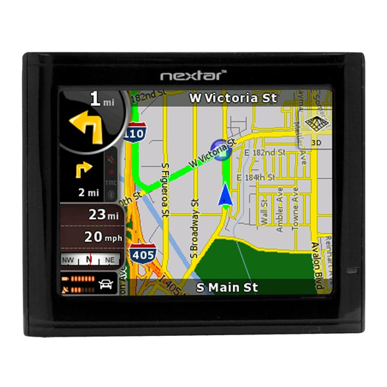
4.1 Map screen Nextar Navigation System is primarily intended for land navigation. That is why maps in Nextar Navigation System look similar to paper road maps. However, Nextar Navigation System provides much more than regular paper maps: you can customize the look and the content of the map. - Page 69 Symbol Battery status GPS position quality Vehicle used in route calculation Top row Next street Bottom row Current house numbers on left and right Map view modes Menu Detour Position menu (appears when navigating a route) Name Opens the Quick menu...
- Page 70 Symbol Cursor menu (appears when there is no GPS position or the Cursor is not at the current GPS position) Open/Close Map control buttons Rotate left, rotate right Tilt up, tilt down Zoom in, zoom out Name Opens the Cursor menu...
- Page 71 Symbol Return to GPS position (appears when GPS position is available and you have moved the map) Enable Smart Zoom (replaces the previous button if there is no GPS position or the map has not been moved) Zoom preset buttons...
-
Page 72: Icons On The Map
• Sound status (muted or enabled) • Track log recording status 4.1.1.1 Battery, GPS position quality and Vehicle type indicator This area is a multiple status indicator, and also acts as a button that opens the Quick menu. Name levels, or to reset it to its original value. - Page 73 You need to recharge the battery. GPS reception quality shows the current accuracy of the position information. Icon Nextar Navigation System has no connection to the GPS receiver: GPS navigation is not possible. Devices permanently connected. On such devices, the icon does not appear in normal circumstances.
-
Page 74: Status Indicator Strip
4.1.1.2 Status indicator strip This is a multiple status indicator. It indicates the following status information on a single strip: Icon The sound output of Nextar Navigation System is muted. The sound output of Nextar Navigation System is enabled. Description Vehicle type... -
Page 75: Next Two Route Events (Turn Preview Fields)
Icon Nextar Navigation System records a Track log when GPS position is available. Track log recording is disabled. 4.1.1.3 Next two route events (Turn Preview fields) There are two fields reserved on the Map screen to display the next two maneuvers (route events that are listed in the Itinerary). Both the type of the event (turn, traffic circle, exiting highway, etc.) and its... -
Page 76: Objects On The Map
4.1.2 Objects on the map 4.1.2.1 Streets and roads Nextar Navigation System shows the streets in a way that is similar to how the paper road maps show them. Their width and colors correspond to their importance: you can easily tell a highway from a small street. -
Page 77: Object Types
3D when you navigate. To fine-tune 3D visualization on the map, tap the following buttons: 4.1.2.3 Elements of the active route Nextar Navigation System shows the route in the following way: Symbo Name... - Page 78 The first point of the route. Normally if GPS position is available, it is the start point of the route. If there is no valid GPS position, Nextar Navigation System uses the last known GPS position as the start point.
- Page 79 You can choose whether you want to use or avoid certain road types (page 107). However, when Nextar Navigation System cannot avoid such roads, the route will include them and it will show them in a color that is...
-
Page 80: Detour Menu
4.1.3 Detour menu This screen contains quick detour possibilities during navigation. It can be opened directly from the Map screen by tapping You have the following options: • On the main part of the screen you can see the first page of Saved Search Criteria. -
Page 81: Button Description
In order to show a part of the map with the Cursor menu, it contains only a few buttons first. Tap Button Description Closes the Cursor menu, and returns to the previous screen. Zooms out the map. Zooms in the map. With the Cursor menu open, you can still move or scale the map, and tap the map anywhere to place the Cursor to a new location, but when... - Page 82 If the Cursor is at or near the selected start point, this button replaces the previous one and deletes the start point from the route. The current GPS position is used again as the start point, and Automatic Off-route Recalculation is re-enabled.
-
Page 83: Position Menu
4.1.5 Position menu When you follow the recommended route on the map (the Cursor is the current GPS position), the Position menu replaces the Cursor menu. It does not contain buttons that modify the current route, as the GPS position is not useful as a route point. - Page 84 • It can be opened directly from the Map screen by tapping the Turn Preview field • In Advanced mode, from the Navigation menu tap the following buttons: In the top section of the screen you see information about the current route.
- Page 85 Name route. The calculation cannot take into account traffic jams and other possible delays. Distance Left Shows the distance you need to travel on the route before reaching your final destination. Time Left Shows the time needed to reach the final destination of the route based on information available for the remaining segments of the route.
-
Page 86: Trip Information Screen
Name Appears only if at least one via point exists. Appears only if there are no via points in the route. 4.1.7 Trip Information screen The Trip Information screen has both route and travel data you might need during your journey. It can be opened directly from the Map screen by tapping the Trip Data field ( The fields on this screen are continuously updated while you keep the screen open. - Page 87 fields concerning your route display data for the next via point. Tap the button repeatedly to toggle between the two options. You have the following data and functions on this screen: Name Shows whether the route data fields show information about the final destination (checkered flag) or about the next via point (yellow flag) .
- Page 88 GPS Time Shows the current time corrected with time zone offset. The accurate time comes from the GPS satellites, and the time zone information comes from the map or it can be set manually in Regional settings. Altitude Shows the elevation if it is provided by the GPS receiver.
-
Page 89: Trip Computer Screen
Name Most of the fields on this screen have a symbol shows whether the field it is attached to is shown on the map as a Trip Data. It also shows the position of the data as follows: Symbol This value is not shown on the map screen. This value appears on the map screen in the Trip Data area. -
Page 90: Quick Menu
This button replaces the previous one if it has been activated. Tap it to resume collecting trip data. Resets all counters of the currently shown trip. Collecting trip data is restarted only when Nextar Navigation System receives a position from the GPS. Cycles through all trips. - Page 91 If you only adjust the volume, you need to use this button to return to the Map screen. Mutes all sounds of Nextar Navigation System. Switches between the daytime and night color schemes manually. This will not disable the automatic...
-
Page 92: Gps Data Screen
4.1.9 GPS Data screen Tap the following buttons: to open the GPS Data screen and to see the status of GPS reception. Icon Color Green Yellow Grey , and then Name GPS position Nextar Navigation System quality indicator has a connection to the... - Page 93 Color Green, blinking Yellow, blinking Red, blinking Sky view circle Name Nextar Navigation System has no connection to the GPS receiver. Since the device has a built-in GPS receiver, this status should not appear under circumstances. Nextar Navigation System connection...
-
Page 94: Find Menu
If you know at least a part of the address, this is the quickest way to find the location. You can select your destination from the thousands of POIs included with Nextar Navigation System or from the ones you have previously created. The destinations that you have already entered in Nextar Navigation System are available in the History list. -
Page 95: Route Menu
Save, load and edit your routes. Tap the following buttons: Button Opens a screen with useful route data. You can browse the driving instructions that Nextar Navigation System follows during maneuvers or streets to adjust the route to your preferences. -
Page 96: Manage Menu
You can run a demonstration of the route at high speed. You can run a demonstration of the route at normal speed. 4.4 Manage menu You can manage the content that Nextar Navigation System stores. Tap the following buttons: Description (start point,... -
Page 97: Manage Saved Routes
Button Renaming or deleting saved routes Deleting History items Recording, simulating, renaming or deleting track logs, assigning color to them to be shown on the map Renaming or deleting Favorites Creating, updating or deleting POIs Creating, updating or deleting POI groups Modifying POI visibility settings Creating, renaming or deleting Saved Search Criteria... -
Page 98: Manage History
Button 4.4.2 Manage History You can manage the list of locations you used lately. Tap the following buttons: Button 4.4.3 Manage Track Logs You can record Track Logs, then play them back, display them on the map, and view their details. Tap the following buttons: Moves between pages for additional list items. - Page 99 Button Starts recording the track that you drive. (You can also start recording a track log in the Quick menu.) Stops the ongoing Track Log recording. (You can also stop track log recording in the Quick menu.) Button with the Shows the details of the selected Track Log.
-
Page 100: Manage Favorites
4.4.4 Manage Favorites You can manage the list of your Favorites. Tap the following buttons: Button Button with the name of the Favorite 4.4.5 Manage POIs You can manage your POIs, and set POI visibility for both your POIs and the ones that came with the product. Tap the following buttons: Button / Icon Button with the Opens the list of the subgroups of this POI group. - Page 101 Button / Icon Tap to filter the list to contain only the POIs that you saved. Tap to see all POIs in the list. Creates a new POI group at the given group level. Moves between pages for additional list items. This POI group is not shown on the map.
-
Page 102: Manage Saved Search Criteria
When a POI item is open for editing: Button Button with the name of the POI Button with the icon of the POI 4.4.6 Manage Saved Search Criteria You can manage the list of search criteria previously saved to easily find frequently searched POI types. -
Page 103: User Data Management
Button 4.4.7 User Data Management You can manage the data you have saved (Pins, POIs, Favorites, History, and Track logs) and the settings you have made in the program. Tap the following buttons: Button Remove Pins Backup User Data Restore User Data Delete User Data Moves between pages for additional list items. -
Page 104: Settings Menu
Reset Factory Settings 4.5 Settings menu You can configure the program settings, and modify the behaviour of Nextar Navigation System. Tap the following buttons: The Settings menu has two pages of submenus. Tap the other options. Button You can fine-tune the appearance and content of the Map screen. - Page 105 You can control how Nextar Navigation System behaves during navigation. You can enable some useful warnings, and disable the touch screen in a moving vehicle with Safety Mode.
-
Page 106: Map Screen Settings
3D when you navigate. Nextar Navigation System is able to show the map and the menus in different colors during the day and during the night. Select the color... -
Page 107: Sound Settings
Button Lane Information 4.5.2 Sound settings You can adjust the sounds of Nextar Navigation System. Tap the following buttons: Button Master Volume Voice Guidance Volume Key Sounds Description immediately. Some maps contain lane information to help you position your car in the upcoming intersection. -
Page 108: Route Planning Options
When driving at high speed, the noise in the car may be too loud to clearly hear the voice guidance and other sounds. Using Dynamic Volume you can instruct Nextar Navigation System to increase the volume when your speed exceeds a certain minimum, and reach its highest volume at the given maximum speed. - Page 109 Toll By default Nextar Navigation System includes toll roads (pay roads roads where there is a per-use charge) in the routes. If you disable toll roads, Nextar Navigation System plans the best toll-free route.
- Page 110 You might need a permit or permission from the owners to needed use certain roads or to enter certain areas. Ferries Nextar Navigation System includes ferries in a planned route by default. However, a map does not necessarily contain information about the accessibility of temporary ferries. You might also need to pay a fare on ferries.
-
Page 111: Regional Settings
Fast route, but it takes other roads as well to save fuel. Easy Results in a route with fewer turns. With this option, you can make Nextar Navigation System to take, for example, the highway instead of series of smaller roads or streets. 4.5.4 Regional settings... -
Page 112: Time And Time Zone Settings
You can access time and time zone settings. Nextar Navigation System helps you with correcting the device time to the ever accurate GPS time. Nextar Navigation System can also help you set the time zone based on your current GPS position. -
Page 113: Navigation Settings
Button Compare GPS and device times 4.5.5 Navigation settings You can control how Nextar Navigation System behaves during navigation. Tap the following buttons: Button Keep Position on Road Off-route Recalculation Description time. The current time of the GPS receiver and the device clock are displayed. -
Page 114: Warning Settings
Button Warn When Maps may contain information about the speed Speeding limits of the road segments. Nextar Navigation Description automatically disable this feature. If you have moved or rotated the map during navigation, this feature moves the map back to... - Page 115 Button System is able to warn you if you exceed the current limit. This information may not be available for your region (ask your local dealer), or may not be fully correct for all roads in the map. This setting lets you decide whether you wish to receive the warnings.
-
Page 116: Gps Settings
4.5.7 GPS settings You can set up the connection to the GPS receiver. Tap the following buttons: Button GPS receiver ... GPS Enabled 4.5.8 Menu settings You can modify the look and behaviour of the Menu screens. Tap the following buttons:... -
Page 117: Device Settings
4.5.9 Device settings You can change some device settings to control the screen backlight when Nextar Navigation System is running. Tap the following buttons: Button Power Management You can set how the backlight will behave when Backlight Intensity at Daytime... - Page 118 Independently of the normal track log, you can instruct Nextar Navigation System to record the native GPS data received from the GPS device. These logs are saved as separate text files on the memory card, and they cannot be shown or replayed in Nextar Navigation System.
-
Page 119: Glossary
2D reception is possible. Active route The currently navigated route. You can save and load routes in Nextar Navigation System, but only one route can be active at any given time, and it is always active until you delete it, reach your destination or you quit Nextar Navigation System. -
Page 120: Overview Mode
Nextar Navigation System works with digital maps which are not simply the computerised versions of traditional paper maps. Similarly to the paper road maps, the 2D mode of digital maps show you streets, roads, and elevation is also shown by colors. - Page 121 2D and 3D modes, and they display shades or shadows in different ways in 3D mode. One daytime scheme and one night scheme is always selected. Nextar Navigation System uses them when it switches from day to night and back. Track-up map orientation In Track-up mode the map is rotated so its top always points in the current driving direction.
-
Page 122: End User Licence Agreement
6 End User Licence Agreement 1 The contracting parties 1.1 Contracting parties to this Agreement are, on the one hand: Nav N Go Kft. (23 Bérc utca, H-1016 Budapest, Hungary; Hungarian reg.no.: 01-09-891838) as Licensor the legal user (as defined in Section 2) of the object of this Agreement according to Section 4, hereinafter referred to as User on the other hand (hereinafter jointly referred to as Parties). - Page 123 3.2 This agreement is issued in NOTE TO TRANSLATOR - PLEASE INSERT YOUR LANGAUGE and in Hungarian. In case of dispute the Hungarian text shall prevail. 4 The object of the Agreement 4.1 The object of this Agreement shall be the navigation guidance software product of Licensor (hereinafter referred to as Software Product).
- Page 124 5.5 By concluding this Agreement, Licensor shall withhold all rights vested in the Software Product, except for those that the User is entitled to according to explicit legal regulations or that of this Agreement. 6 Rights of the User 6.1 The User is entitled to install the Software Product on one hardware device (desktop, handheld, portable computer, navigation device) at a time, and to run and use one copy thereof.
- Page 125 8.1 Licensor hereby informs the User that although the greatest care was taken in producing the Software Product, yet with respect to the essence of the Software Product and the technical limitations, the Licensor does not warrant for the Software Product being completely error-free, and the Licensor is not bound by any contractual obligation by which the Software Product obtained by the User should be completely error-free.
- Page 126 9.1.2 claim ceasing the breach and ordering the person under breach from continuing such; 9.1.3 claim that the person under breach give proper compensation (even by way of publicity, to the expense of the person under breach); 9.1.4 claim the return of the increase of assets due to the breach; 9.1.5 claim ceasing the breaching situation, the restitution of the state before the breach, to the expense of the person in breach, and may claim the destruction of instruments and materials used for the breach,...
-
Page 127: Copyright
Nextar, Inc. Any unauthorized distribution of this manual is expressly forbidden. Nextar may find it necessary to modify, amend, otherwise change, or update this manual. We reserve the right to do this at any time, without any prior notice. All specifications and features are subject to change without notice.