Garmin GNS 430 Pilot's Manual And Reference
Hide thumbs
Also See for GNS 430:
- Pilot's manual & reference (267 pages) ,
- Operating manual (27 pages) ,
- Quick reference (23 pages)
Table of Contents
Advertisement
Quick Links
Advertisement
Table of Contents

Subscribe to Our Youtube Channel
Related Manuals for Garmin GNS 430


Summary of Contents for Garmin GNS 430
- Page 1 GNS 430/430A Pilot’s Guide and Reference...
- Page 3 7/00 Updated Power On, Wind Vector, Crossfill, DME, and Fuel Plan 5/03 Added FDE Section, updated per SW 5.01, misc. changes 5/06 Changed to 8 inch x 8.5 inch format. Added TERRAIN, misc. changes GNS 430 Pilot’s Guide and Reference...
- Page 4 Garmin®, AutoLocate®, and PhaseTrac12® are registered trademarks of Garmin Ltd. or its subsidiaries and may not be used without the express permission of Garmin. GNS™ and Spell’N’Find™ are trademarks of Garmin Ltd. or its subsidiaries and may not be used without the express permission of Garmin.
-
Page 5: Table Of Contents
8.4 Nearest NDB Page ............ 8-6 SECTION 2: COM ..............2-1 8.5 Nearest VOR Page ............ 8-6 2.1 Communicating using the GNS 430...... 2-1 8.6 Nearest User Waypoint Page ......... 8-8 8.7 Nearest Center (ARTCC) Page........ 8-8 SECTION 3: NAV PAGES .......... - Page 6 Always use pressure altitude displayed by pressure altimeters in the aircraft. WARNING: The Jeppesen database used in the GNS 430 system must be updated regularly in order to ensure that its information remains current. Updates are released every 28 days. A database information packet is included in the GNS 430 package.
- Page 7 WARNINGS, CAUTIONS, AND NOTES WARNING: Use the GNS 430 at your own risk. To reduce the risk of unsafe operation, carefully review and understand all aspects of the GNS 430 Pilot’s Guide documentation and the GNS 430 Flight Manual Supplement.
- Page 8 Garmin retains the exclusive right to repair or replace the unit or software, or to offer a full refund of the purchase price, at its sole discretion.
-
Page 9: Section 1: Introduction
INTRODUCTION SECTION 1: INTRODUCTION The Garmin dealer performs the installation and configuration of the GNS 430. The GNS 430 is secured in the installation rack with the proper wiring connections 1.1 ACCESSORIES AND PACKING LIST performed. After installation, the NavData card and the Terrain Data card (if applicable) are installed into the Congratulations on choosing the finest, most advanced... -
Page 10: Key And Knob Functions
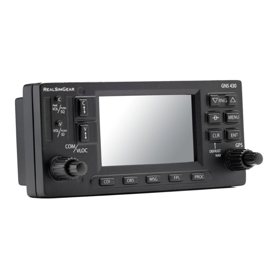
Experiment with the unit and refer to the reference sections for more information. The GNS 430 is designed to make operation as simple Data is entered using the large and small knobs. as possible. The key and knob descriptions (Figure Experiment with them to become efficient at entering data. - Page 11 The small right knob is also used to move the target pointer up (turn clockwise) or down (counterclockwise) when the map panning function is active. GNS 430 Pilot’s Guide and Reference...
- Page 12 SECTION 1 INTRODUCTION Bottom Row Keys NOTE: When the GNS 430 is displaying a list of information that is too long for the display The CDI Key is used to toggle which navigation source screen, a scroll bar appears along the right-hand (GPS or VLOC) provides output to an external HSI or side of the display (Figure 1-2).
-
Page 13: Takeoff Tour
fields, etc.) have been changed, the pictures shown here may not exactly match what is shown on the GNS 430. Prior to using the GNS 430 for the first time, Garmin recommends that the aircraft be moved to a location that is well away from buildings and other aircraft so the unit can collect satellite data without interruption. - Page 14 The Database Confirmation Page (Figure 1-4) appears next, which shows the current database information on To ensure that the GNS 430 and any connected the NavData card (with the valid operating dates, cycle instruments are working properly, check for the following number, and database type indicated).
- Page 15 Once instrument operation has been verified with the Instrument Panel Self-test Page displayed, press the ENT Key. NOTE: The GNS 430 can hold up to nine checklists with up to 30 entries in each checklist. Figure 1-7 ‘Set Full Fuel?’ Highlighted Press the ENT Key and verify that fuel on board (‘FOB’) now matches the fuel capacity (CAP)
- Page 16 fix is being operating condition. determined. Following the first-time use of the GNS 430, the time required for a position fix varies, usually from one to two minutes.
- Page 17 Press the COM Flip-flop Key (Figure 1-12). minute to dial in the active and standby frequencies to be used for the first phase of the flight. The GNS 430’ s display is divided into separate ‘windows’ (or screen areas), including a COM Window, VLOC Window, and the GPS Window (Figure 1-11).
- Page 18 (WPT), auxiliary NOTE: *Eight NAV pages are available when (AUX) functions such as flight planning or unit settings, and the GNS 430 installation includes connection listings for nearest (NRST) airports or other facilities. to traffic and/or weather information sources.
- Page 19 To change the map range, press the up arrow (to zoom out) or the down arrow (to zoom in) of the RNG (map After the GNS 430 acquires satellites and computes range) Key. The current map range is depicted in the a position, the Map Page (Figure 1-14) appears lower left corner of the Map Display.
- Page 20 Course Deviation TO/FROM Flag Indicator (CDI) Figure 1-19 ‘Select Field Type’ Window Figure 1-17 Default NAV Page Press the ENT Key to select the desired data item and return to the Default NAV Page. 1-12 GNS 430 Pilot’s Guide and Reference...
- Page 21 (departure, arrival, and enroute) for the flight plan or direct-to. Continue to turn the small right knob until the desired airport is selected. Press the ENT Key to display the frequency list for the selected airport. GNS 430 Pilot’s Guide and Reference 1-13...
- Page 22 Press the ENT Key to display a list of available procedures for the arrival (when using approaches or STARs) or departure (when using SIDs) airport. Turn the small right knob to select the desired procedure and press the ENT Key. 1-14 GNS 430 Pilot’s Guide and Reference...
- Page 23 COM or VLOC field by airport is replaced with the sequence of waypoints highlighting the frequency with the cursor and pressing contained within the selected procedure. the ENT Key. GNS 430 Pilot’s Guide and Reference 1-15...
- Page 24 (The pilot still has the option of returning to the flight plan by cancelling the direct-to; see Section 4.1, Cancelling Direct-to Navigation.) Figure 1-25 Scrolling the Nearest Airport List 1-16 GNS 430 Pilot’s Guide and Reference...
- Page 25 • If the aircraft has entered an airspace, the message ‘Inside airspace’ appears. Figure 1-27 ‘Activate?’ Highlighted Press the ENT Key again to navigate to the nearby airport. Figure 1-28 Nearest Airspace Page GNS 430 Pilot’s Guide and Reference 1-17...
- Page 26 By default, airspace alert messages are turned off. When turned on, the message (MSG) annunciator located directly The GNS 430 lets the pilot create up to 20 flight plans above the MSG Key flashes to alert the pilot to the airspace with up to 31 waypoints in each flight plan.
- Page 27 Since using flight plans is arguably one of the more for the flight plan have been entered (Figure complex features of the GNS 430, it will be discussed only 1-33). briefly here, with focus on creating a new flight plan and activating it to use for navigation.
- Page 28 SECTION 1 INTRODUCTION Blank Page 1-20 GNS 430 Pilot’s Guide and Reference...
-
Page 29: Section 2: Com
2-1), using the small and large left knobs to dial in the desired frequency. The standby frequency always appears The GNS 430 features a digitally-tuned VHF COM radio below the active frequency. The active frequency is that provides a seamless transition from communication... - Page 30 Window, press the small left knob momentarily left knob momentarily to place the cursor in the VLOC (Figure 2-3). Window. Additional instructions for VOR/localizer/ILS operations are available in Sections 6 and 9. Figure 2-3 Standby Frequency of 135.325 GNS 430 Pilot’s Guide and Reference...
- Page 31 To display the entire list of frequencies for a nearby airport and select from that list: The GNS 430’ s auto-tune feature allows the pilot to Start with the desired airport highlighted on quickly select any database frequency in the GPS Window the Nearest Airport Page (as described in the as the standby frequency.
- Page 32 Press the ENT Key to return to the NAV/COM Page with the frequencies for the selected airport. Turn the large right knob to highlight the desired frequency. Press the ENT Key to place the highlighted frequency in the standby COM Window field. GNS 430 Pilot’s Guide and Reference...
- Page 33 Emergency Channel To select a COM frequency for any airport in the database: The GNS 430’ s emergency channel select provides Turn the large right knob to select the NRST a quick method of selecting 121.500 MHz as the Page Group.
- Page 34 COM transmitter automatically times out (ceases transmitting) after 35 seconds of continuous broadcasting. A ‘COM push-to- talk key stuck’ message (Figure 2-11) is displayed as long as the condition continues. Figure 2-11 Message Page GNS 430 Pilot’s Guide and Reference...
-
Page 35: Section 3: Nav Pages
3.1 MAIN PAGE GROUPS Default NAV Page. Turn the large right knob to select the desired page group (Table 3-1 and The GNS 430’ s main pages are divided into four Figure 3-1). separate page groups: NAV, WPT, AUX, and NRST To select the desired page within the (Table 3-1). -
Page 36: Default Nav Page
SECTION 3 NAV PAGES 3.3 DEFAULT NAV PAGE NOTE: The GNS 430 always navigates TO a waypoint unless the OBS switch is set The first NAV page is the Default NAV Page (Figure (preventing automatic waypoint sequencing), 3-3). This page may be quickly selected from any page by or if the aircraft has passed the last waypoint pressing and holding the CLR Key. - Page 37 If no flight plan or direct-to destination has been selected, only speed, track, altitude, and minimum safe altitude data may be displayed. All other data types appear as blank lines on the Default NAV Page until a destination is selected. GNS 430 Pilot’s Guide and Reference...
- Page 38 A ‘Crossfill?’ option is also provided for the Default NAV Page. This option transfers a direct-to destination or flight plan to a second Garmin 400 Series unit. See Section 10.2, Flight Planning: Crossfill for additional details on using the crossfill option.
-
Page 39: Map Page
VORTAC Current Page Group Figure 3-8 Map Page TACAN NOTE: If the GNS 430 is unable to determine a GPS position, the present position (airplane) symbol does not appear on the Map Page. Locator Outer Marker The Map Display can be set to 23 different range... - Page 40 Section 3.4. The four data fields can also be removed from the map to show a larger map image, as described in Figure 3-9 Overzoom on Map Page Section 3.4. GNS 430 Pilot’s Guide and Reference...
- Page 41 Turn the large right knob to move right (turn Press the CLR Key to exit the information clockwise) or left (counterclockwise). page(s). To cancel the panning function and return to the present position, press the small right knob. GNS 430 Pilot’s Guide and Reference...
- Page 42 The direct-to function can be used anywhere on the map. If nothing currently exists at the target pointer location, a new waypoint called ‘+MAP’ (Figure 3-13) is created at the target pointer location before the direct-to is initiated. GNS 430 Pilot’s Guide and Reference...
- Page 43 Press the ENT Key to display an options menu (Figure 3-15). Many of the GNS 430’ s functions are menu driven. Each of the main pages has an options menu, allowing customization of the corresponding page to the pilot’ s preferences and/or selection of special features which specifically relate to that page.
- Page 44 Map Display to the current track NOTE: Large, medium, and small classifications heading. are used on the GNS 430 for airports and cities. Large airports are those with a runway longer than 8100 feet. Medium airports include those with a runway longer than 5000 feet or with a control tower.
- Page 45 From the Map Page Menu, turn the large right Press the ENT Key to accept the selected knob to highlight ‘Setup Map?’ and press the option. ENT Key. Turn the small right knob to select ‘Map’ and press the ENT Key. GNS 430 Pilot’s Guide and Reference 3-11...
- Page 46 fields are off, ‘Data Fields On?’ appears as an option instead. Figure 3-20 Map Page Menu Press the ENT Key, an on-screen reference pointer appears on the Map Display at the Figure 3-22 Full Screen Map present position. 3-12 GNS 430 Pilot’s Guide and Reference...
- Page 47 ‘Change Fields?’ (Figure additional data types. Traffic information is only 3-23) and press the ENT Key. available when the GNS 430 installation includes connection to traffic information sources. See 400 Series Pilot’s Guide Addendum, part number 190-00140-13.
-
Page 48: Terrain Page
Select the TERRAIN Page and press the MENU NOTE: The TERRAIN Page does not appear on Key. GNS 430 units that are not properly equipped Select ‘View 360˚?’ (Figure 3-27). with or configured for TERRAIN. See Section 11 for a full description of TERRAIN functions. -
Page 49: Inhibit Mode
100 nm (Figure 3-28). Figure 3-29 TERRAIN Page Menu Inhibit Mode The Garmin TERRAIN system provides an ‘inhibit mode’. This mode is designed to deactivate terrain alerting when deemed unnecessary by the pilot. Flying VFR into an area where unique terrain exists could cause the system to annunciate nuisance alerts. - Page 50 >1000 feet AGL <1000 feet AGL Key. ‘Enable Terrain?’ is selected by default. Press the ENT Key. The TERRAIN system is functional again. Lighted Potential Obstacles Impact Points >1000 feet AGL Figure 3-32 TERRAIN Symbols 3-16 GNS 430 Pilot’s Guide and Reference...
-
Page 51: Nav/Com Page
Arrival Airport (when applicable) Figure 3-34 Airport Window Position of Current Page within Current Page Group Frequency Type Number of Pages in Current Page Group Current Page Group Figure 3-33 NAV/COM Page GNS 430 Pilot’s Guide and Reference 3-17... - Page 52 Figure 3-37 Restriction Information Page • ‘TX’ - Transmit only To return to the NAV/COM Page, press the ENT • ‘RX’ - Receive only Key. • ‘PT’ - Part time frequency 3-18 GNS 430 Pilot’s Guide and Reference...
-
Page 53: Position Page
Figure 3-40 Select Field Type Window within approximately ten miles of the present position. MSA is calculated from the information contained in the database and generally takes into account mountains, buildings, and other permanent features. GNS 430 Pilot’s Guide and Reference 3-19... - Page 54 3-41). waypoint. Press the ENT Key to confirm the selected waypoints. Press the small right knob to remove the cursor. Figure 3-41 Waypoint Type Field Highlighted Figure 3-43 Reference Waypoint Field Highlighted 3-20 GNS 430 Pilot’s Guide and Reference...
- Page 55 Figure 3-44 Mode Window Figure 3-45 Position Page Menu Press the small right knob momentarily to remove the cursor from the page. Turn the large right knob to highlight ‘Restore Defaults?’ and press the ENT Key. GNS 430 Pilot’s Guide and Reference 3-21...
-
Page 56: Satellite Status Page
Signal Strength Bars Excluded Satellite Current Page Group Figure 3-47 Hollow Signal Strength Bars Number of Pages in Current Page Group Positon of Current Page within Current Page Group Figure 3-46 Satellite Status Page 3-22 GNS 430 Pilot’s Guide and Reference... - Page 57 (solid signal strength bar, see Figure 3-46). Once the GPS Level (HUL) figures. DOP measures satellite geometry receiver has determined the present position, the GNS 430 quality (i.e., number of satellites received and where they indicates position, track, and ground speed on the other are relative to each other) on a scale from one to ten.
-
Page 58: Vertical Navigation Page
NOTE: To use the vertical navigation features, ground speed must be greater than 35 knots The GNS 430’ s Vertical Navigation Page (the last NAV and the pilot must be navigating to a direct-to page, see Figure 3-48) creates a three-dimensional profile destination or using a flight plan. - Page 59 (Figure 3-52) and press the ENT Key. If the target altitude should occur at the target reference waypoint, enter a distance of zero. Figure 3-53 VS Profile Field Selected Figure 3-52 Reference Distance Selected GNS 430 Pilot’s Guide and Reference 3-25...
- Page 60 Vertical navigation messages can be turned on or off. (By default the messages are off.) Turning the messages off allows the pilot to keep the previous profile settings, without having them generate messages when the feature isn’t needed. 3-26 GNS 430 Pilot’s Guide and Reference...
-
Page 61: Section 4: Direct-To Navigation
The GNS 430’ s direct-to function provides a quick method of setting a course to a destination waypoint. Once a direct-to is activated, the GNS 430 establishes a point-to-point course line (great circle) from the present position to the selected direct-to destination. Navigation Figure 4-2 Waypoint Identifier Field Selected... - Page 62 City destination waypoint (Figure 4-5). When In addition to selecting a destination by identifier, the spelling the facility name or city, the GNS 430’s Select Direct-to Waypoint Page (Figure 4-4) also allows the Spell’N’Find™ feature selects the first entry pilot to select airports, VORs and NDBs by facility name in the database based upon the characters or city location.
- Page 63 Press the ENT Key to confirm the selected waypoint. airport, and press the ENT Key again to activate Press the ENT Key to confirm the selected the direct-to function. waypoint, and press the ENT Key again to activate the direct-to function. GNS 430 Pilot’s Guide and Reference...
- Page 64 Figure 4-10), the desired waypoint must be highlighted desired waypoint. with the cursor before pressing the Direct-to Key. Press the Direct-to Key followed by the ENT Key twice. Figure 4-9 Single Waypoint Displayed Figure 4-10 Nearest List GNS 430 Pilot’s Guide and Reference...
- Page 65 Selecting a Direct-to destination from the Map Cancelling Direct-to Navigation Page Once a direct-to is activated, the GNS 430 provides navigation guidance to the selected destination until the Direct-to destinations may also be selected from the direct-to is replaced with a new direct-to or flight plan, Map Page.
- Page 66 Specifying a Course to a Waypoint Turn the small and large right knobs to select the desired course (Figure 4-14) and press the When performing a direct-to, the GNS 430 sets a direct ENT Key. great circle course to the selected destination. The course to the destination can also be manually defined using the...
-
Page 67: Section 5: Flight Plans
5.1 FLIGHT PLAN CATALOG PAGE The Flight Plan Catalog Page allows the pilot to create, The GNS 430 lets the pilot create up to 20 different edit, activate, delete, and copy flight plans. Flight plans flight plans, with up to 31 waypoints in each flight plan. - Page 68 Turn the large right knob to select the point to add the new waypoint. If an existing waypoint Figure 5-6 Edited Flight Plan Page is highlighted, the new waypoint is placed directly in front of this waypoint (Figure 5-4). GNS 430 Pilot’s Guide and Reference...
- Page 69 Flight Plan Key when finished. Catalog Page. Figure 5-7 Comment Line Selected Once all changes have been made, press the small right knob to return to the Flight Plan Catalog Page. GNS 430 Pilot’s Guide and Reference...
- Page 70 Flight Plan?’ and press the ENT Key (Figure Key. The original flight plan remains intact in 5-8). its flight plan catalog storage location. Figure 5-8 Flight Plan Catalog Page Menu Figure 5-9 Flight Plan Catalog Page Menu GNS 430 Pilot’s Guide and Reference...
- Page 71 flight plan number, use the small and large right knobs to enter a different number and press the ENT Key. With ‘Yes?’ highlighted, press the ENT Key to copy the flight plan. GNS 430 Pilot’s Guide and Reference...
- Page 72 ‘Transfer’ field. Use the small and large right knobs to enter the number of the flight plan or the name of the user waypoint to be transferred. GNS 430 Pilot’s Guide and Reference...
- Page 73 flight plan from the database or user waypoint memory. • ‘Delete All Flight Plans?’ - Allows the pilot to remove all flight plans from memory. GNS 430 Pilot’s Guide and Reference...
-
Page 74: Active Flight Plan Page
Figure 5-17 Flight Plan Catalog Page Menu To access the Active Flight Plan Menu Page: Press the FPL Key to view the Active Flight Plan Page. Press the MENU Key (Figure 5-19). Figure 5-19 Active Flight Plan Page Menu GNS 430 Pilot’s Guide and Reference... - Page 75 Activate Leg which is currently used for navigation guidance). Allows the pilot to transfer the active flight plan between two 400- or 500-series Garmin units Crossfill in a dual unit installation. See Section 10.2, Flight Planning: Crossfill for additional information on this feature.
- Page 76 (Figure 5-21) and press the ENT Key. A confirmation window appears. With ‘Activate?’ highlighted, press the ENT Key. Figure 5-21 Select Field Type Window Press the small right knob to remove the cursor. 5-10 GNS 430 Pilot’s Guide and Reference...
- Page 77 For precision approaches, a reminder window Figure 5-24 Approach Window appears indicating that GPS guidance on such approaches is strictly for monitoring only. To confirm this reminder, highlight ‘Yes?’ and press the ENT Key. GNS 430 Pilot’s Guide and Reference 5-11...
- Page 78 A second window appears listing available transitions for the departure. Turn the small right knob to highlight the desired transition Figure 5-27 Arrivals Window waypoint and press the ENT Key. With ‘Load?’ highlighted, press the ENT Key. 5-12 GNS 430 Pilot’s Guide and Reference...
- Page 79 Figure 5-31 Closest Point of Flight Plan Window A confirmation window appears listing the procedure to be removed. With ‘Yes?’ The GNS 430 displays the bearing (BRG) and highlighted, press the ENT Key. distance (DIST) to the closest point along the flight plan, from the selected reference waypoint.
- Page 80 Press the CLR Key to display a confirmation window (Figure 5-34). Figure 5-32 Highlight Item To Be Deleted Figure 5-34 Remove Waypoint Window With ‘Yes?’ highlighted, press the ENT Key to remove the selected procedure. 5-14 GNS 430 Pilot’s Guide and Reference...
- Page 81 Figure 5-35 Destination Waypoint Highlighted Press the Direct-to Key twice to display an ‘Activate Leg’ confirmation window (Figure 5-36). Figure 5-37 Procedure Header Highlighted Figure 5-36 Activate Leg Window With ‘Activate?’ highlighted, press the ENT Key. GNS 430 Pilot’s Guide and Reference 5-15...
- Page 82 SECTION 5 FLIGHT PLANS Blank Page 5-16 GNS 430 Pilot’s Guide and Reference...
-
Page 83: Section 6: Procedures
All available approaches are stored on the Jeppesen NavData card, and are automatically updated when the new card is inserted into the GNS 430. Subscription information for NavData cards is included in the GNS 430 package. - Page 84 ILS approaches, for example, must be flown by tuning the VLOC receiver to the proper frequency and coupling the VLOC receiver to the external CDI (or HSI). Figure 6-4 ‘GPS’ Designations GNS 430 Pilot’s Guide and Reference...
-
Page 85: Non-Precision Approach Operations
ENT Key. NDB, RNAV, etc.) more accurately using GPS. Many overlay approaches are complex (in comparison to GPS-only approaches). The GNS 430 displays and provides guidance through each leg of the approach, automatically sequencing through each of these legs, up to the missed approach point (MAP). - Page 86 ‘Select’ and ‘Load’ the ap- approach and skip the ‘Load’ process outlined proach in the preceding step 3. The GNS 430 provides both options. Approaches with Procedure Turns ‘Activate’ the ap- The procedure turn portion of an approach is stored proach as one of the legs of the approach.
- Page 87 COM Flip-flop Key to make the ATIS frequency active. Figure 6-10 Procedures Page Figure 6-11 Approach and Transitions Windows Figure 6-9 NAV/COM Page Press the PROC Key, select ‘ActivateApproach?’ and press the ENT Key to activate the approach. GNS 430 Pilot’s Guide and Reference...
- Page 88 Figure 6-12 Sample Approach with Procedure Turn Refer to Figure 6-12 for the following steps: Within 30 nm of the destination airport, the GNS 430 switches from ‘enroute’ mode to ‘terminal’ mode (as indicated in the lower left Figure 6-14 Active Flight Plan Page corner of the screen).
- Page 89 Figure 6-17 Sequence to Inbound Leg Turn to the final approach course. Within 2.0 nm of the FAF (LYH), the GNS 430 switches from terminal mode to ‘approach’ mode. CDI scaling is tightened from 1.0 to 0.3 nm, full scale deflection.
- Page 90 After passing the MAP, if the runway isn’t in sight the Figure 6-18 Sequence to MAP pilot must execute a missed approach. The GNS 430 continues to give guidance along an extension of the final NOTE: When viewing the Map Page, note that course segment (FAF to MAP) until the pilot manually the final course segment is displayed in magenta...
- Page 91 Follow the missed approach procedures, as published on the approach plate, for proper Figure 6-23 Hold Timer climb and heading instructions. The GNS 430 guides the pilot to the holding pattern, along The GNS 430 provides course guidance only the 053° radial from LYH VOR.
- Page 92 The pilot may review the approach sequence by pressing the small right knob and turning the large right knob. Press the FPL Key to Figure 6-25 Select Direct-To Waypoint Page return to the navigation pages. 6-10 GNS 430 Pilot’s Guide and Reference...
- Page 93 As in the last example, within 30 nm of the 10) When crossing the IAF, ‘SUSP’ appears above airport, the GNS 430 switches from enroute to the OBS Key (Figure 6-31), indicating that terminal mode, and the CDI scale transitions automatic sequencing of approach waypoints from 5.0 to 1.0 nm, full scale deflection.
- Page 94 Section 5.2. Figure 6-33 Waypoint Alert 12) At 2.0 nm from the FAF (DEPOY intersection), the GNS 430 switches from terminal mode to approach mode. CDI scaling is tightened from DO NOT USE FOR 1.0 to 0.3 nm, full scale deflection.
- Page 95 (the active leg of the Figure 6-35 Missed Approach flight plan always appears in magenta) and a dashed line extends the course beyond the MAP. Do not follow this extended course. Instead, follow published missed approach procedures. GNS 430 Pilot’s Guide and Reference 6-13...
- Page 96 NOTE: As this manual was being written, the letter/number DME arc names were being replaced with standard five-letter intersection Figure 6-38 Procedures Page names. Either naming convention may be used for an approach. 6-14 GNS 430 Pilot’s Guide and Reference...
- Page 97 10°, a Refer to Figure 6-40 for the following steps. ‘Set course to ###°’ message appears on the Within 30 nm of KTOP, the GNS 430 switches Message Page. from enroute mode to terminal mode and the CDI scale transitions from 5.0 to 1.0 nm, full...
- Page 98 When approaching the FAF, ‘NEXT DTK 214°’ nm, full scale deflection. appears in the lower right corner of the screen (Figure 6-45). Select this course on the CDI (or HSI) using the OBS knob. Figure 6-45 Final Approach Fix 6-16 GNS 430 Pilot’s Guide and Reference...
- Page 99 final approach course. There are several ways to select ‘vectors to final’ with the GNS 430. The first two options below normally require the least workload to accomplish: • When the approach is first selected, choose Figure 6-46 Final Course Segment ‘VECTORS’...
- Page 100 (magenta is used to depict the active leg of the 6.1. flight plan) and ‘VTF’ appears as part of the active leg on the Default NAV Page (as a reminder that the approach was activated with vectors-to-final). 6-18 GNS 430 Pilot’s Guide and Reference...
- Page 101 ATC instructs the pilot to turn right to a heading Figure 6-51 for the following steps): of 175° to intercept the final approach course. Within 30 nm of KTOP, the GNS 430 switches When converging with the final approach course from enroute mode to terminal mode and the the needle moves toward the center.
- Page 102 Figure 6-56 Approach Mode When approaching the FAF, a waypoint alert (‘NEXT DTK 214°’) appears in the lower right corner (Figure 6-57). Figure 6-58 Final Approach 6-20 GNS 430 Pilot’s Guide and Reference...
- Page 103 Jeppesen database contain course from fix flight At the initial approach fix (PMD), a waypoint plan legs. The GNS 430 is able to load these legs into the alert (‘NEXT DTK 070°’) appears in the lower flight plan along with the rest of the procedure data, and right corner of the screen.
- Page 104 OBS Key, indicating that automatic sequencing of approach waypoints is suspended at the MAP. If a missed approach is required, use the OBS Key to initiate the missed approach sequence, as outlined below. 6-22 GNS 430 Pilot’s Guide and Reference...
- Page 105 Note that within a few seconds of pressing the OBS Key to release suspend mode and start the approach sequence, ‘SUSP’ re-appears above the OBS Key as the GNS 430 returns to suspend mode. This is normal when flying a course from fix to altitude leg and indicates Figure 6-67 Waypoint Alert that automatic leg sequencing is suspended.
- Page 106 Flight Plan Page and the Default NAV Page: of the holding pattern. COASTAL ONE DEPARTURE Note that the GNS 430 again displays ‘SUSP’ (CSTL1.CCC) above the OBS Key. Automatic waypoint DEPARTING BARNES MUNI,...
- Page 107 Figure 6-71 Waypoint Alert and ‘SUSP’ appears directly above the OBS When the OBS Key is pressed, the GNS 430 Key, which indicates the aircraft is now on the automatically sequences to each waypoint ‘course from fix to manual sequence’...
-
Page 108: Ils Approaches
VLOC Window (left side of screen) and the CDI output set to ‘VLOC’. The GNS 430 can be set to automatically switch the external CDI output from GPS to VLOC as the pilot intercepts the final approach course. When the ILS approach is activated, the GNS 430 automatically switches within 1.2 nm left or right of the final approach course. - Page 109 Select Flagstaff Pulliam (KFLG) as the approach examples (refer to Figure 6-73 for the following destination, using the Direct-to Key or as the steps). last waypoint in a flight plan (Figure 6-74). Figure 6-74 Select Waypoint GNS 430 Pilot’s Guide and Reference 6-27...
- Page 110 When an ILS approach is loaded or activated, the ILS frequency is automatically placed in the standby field of the VLOC Window. To use this frequency, press the VLOC Flip-flop Key to place it in the active frequency field. 6-28 GNS 430 Pilot’s Guide and Reference...
- Page 111 SECTION 6 PROCEDURES Within 30 nm of KFLG, the GNS 430 switches Press the VLOC Flip-flop Key to activate the from enroute mode to terminal mode and the ILS frequency. If this step is forgotten, the GNS CDI scale transitions from 5.0 to 1.0 nm, full 430 displays a reminder message (within 3 nm scale deflection.
- Page 112 HSI is now coupled to the VLOC receiver. GPS After approximately one minute, make a turn approach mode is not activated for precision to intercept the ILS. The GNS 430 sequences to approaches, since the VLOC receiver must be the inbound leg and ‘NEXT DTK 210°’ (Figure used for primary navigation.)
- Page 113 Map Page as in Figure 6-87, note that the final course segment is displayed in magenta (the active leg of the flight plan always appears in magenta), and a dashed line extends the course beyond the MAP.) GNS 430 Pilot’s Guide and Reference 6-31...
-
Page 114: Points To Remember For All Approaches
APPROACHES automatic sequencing of approach waypoints is suspended at the MAP. A ‘FROM’ indication • The GNS 430 is designed to complement printed is displayed on the CDI and Default NAV Page, approach plates and vastly improve situational but course guidance along the final approach awareness throughout the approach. - Page 115 FAF (depending upon the performance characteristics of the autopilot and aircraft). In such cases, the pilot should manually fly the approach or refer to the documentation provided with the autopilot. GNS 430 Pilot’s Guide and Reference 6-33...
- Page 116 SECTION 6 PROCEDURES Blank Page 6-34 GNS 430 Pilot’s Guide and Reference...
-
Page 117: Section 7: Wpt Pages
7.1 WPT PAGE GROUP skipped if the unit is already displaying any of the main pages.) Section 3.1 introduced the GNS 430’ s main page groups Turn the large right knob to select the WPT (Table 7-1)—NAV, WPT, AUX, NRST—and described Page Group. - Page 118 Figure 7-4 VOR Page name or location (city) field. Turn the small right knob to select the desired To remove the flashing cursor, press the small character (Figure 7-2). right knob. Figure 7-2 Airport Location Page GNS 430 Pilot’s Guide and Reference...
- Page 119 When entering an identifier, facility name, or location, the GNS 430’ s Spell’N’Find feature scrolls through the database, displaying those waypoints matching the characters that have been entered to that point.
-
Page 120: Airport Location Page
Airport Identifier, Symbol, and Type Field Elevation and Available Fuels Airspace Type Best Available Approach Current Page Group Position of Current Page within Current Page Group Number of Pages in Current Page Group Figure 7-8 Airport Location Page GNS 430 Pilot’s Guide and Reference... -
Page 121: Airport Runway Page
Press the ENT Key to display information for Current Page Group the selected runway on the Airport Runway Figure 7-9 Airport Runway Page Page (Figure 7-11). Figure 7-11 Airport Runway Page To remove the flashing cursor, press the small right knob. GNS 430 Pilot’s Guide and Reference... -
Page 122: Airport Frequency Page
Current Page Group Current Page Group Figure 7-12 Airport Frequency Page To scroll through the frequency list and tune to a desired frequency on the list: Press the small right knob to activate the cursor. GNS 430 Pilot’s Guide and Reference... - Page 123 (Figure 7-16). Figure 7-14 Frequency Moved to Standby Field To remove the flashing cursor, press the small right knob. Figure 7-16 Restriction Information Page To return to the Airport Frequency Page, press the ENT Key. GNS 430 Pilot’s Guide and Reference...
-
Page 124: Airport Approach Page
To scroll through the available approaches and transitions: Press the small right knob to activate the cursor. Turn the large right knob to place the cursor on the approach (APR) procedure name field (Figure 7-17). GNS 430 Pilot’s Guide and Reference... - Page 125 (Figure 7-19). Continue turning the small right knob to select the desired transition or select ‘VECTORS’ for guidance only along the final course segment of the approach. Figure 7-19 Transitions Window GNS 430 Pilot’s Guide and Reference...
- Page 126 Approach Page, follow the steps above, but select ‘Load Select the desired approach and transition and Activate?’ in step 3. using the steps outlined in Section 6.1 (Figure 7-20). Press the MENU Key to display the Airport Approach Page Menu. 7-10 GNS 430 Pilot’s Guide and Reference...
-
Page 127: Airport Arrival Page
Figure 7-24 Transitions Window Turn the large right knob to place the cursor on the arrival (ARVL) procedure name field Press the ENT Key. The cursor moves to the (Figure 7-22). runway field. GNS 430 Pilot’s Guide and Reference 7-11... - Page 128 Press the ENT Key. To remove the flashing cursor, press the small right knob. Figure 7-26 Airpoirt Arrival Page Menu The Active Flight Plan Page appears. Press the FPL Key to return to the Airport Arrival Page. 7-12 GNS 430 Pilot’s Guide and Reference...
-
Page 129: Airport Departure Page
(Figure 7-28). Continue turning the small right transition. knob to select the desired departure. Press the ENT Key. To remove the flashing cursor, press the small right knob. GNS 430 Pilot’s Guide and Reference 7-13... -
Page 130: Intersection Page
NOTE: The VOR displayed on the Intersection Page is the nearest VOR, not necessarily the VOR used to define the intersection. Intersections may only be selected by identifier, as described in Section 7.1. 7-14 GNS 430 Pilot’s Guide and Reference... -
Page 131: Ndb Page
As mentioned in Section 7.1, VORs may be selected by identifier, facility name, or location (city). The VOR Page may also be used to quickly tune the VLOC receiver to the selected VOR’ s frequency. GNS 430 Pilot’s Guide and Reference 7-15... - Page 132 Key when finished. Figure 7-35 Frequency Field Highlighted To activate the standby VLOC frequency, press the VLOC Flip-flop Key (Figure 7-36). Figure 7-34 VOR Identifier Field Selected Figure 7-36 Activate the Standby Frequency 7-16 GNS 430 Pilot’s Guide and Reference...
-
Page 133: User Waypoint Page
Jeppesen NavData card, waypoint, simply enter its name (identifier) and position, the GNS 430 allows the pilot to store up to 1,000 user- or reference another waypoint by radial and distance. defined waypoints. The User Waypoint Page (Figure 7-37) displays the waypoint name (up to five characters... - Page 134 The cursor moves to the distance (DIS) field. Use the small and large right knobs to enter the distance from the reference waypoint to the new user waypoint. Press the ENT Key to accept the selected distance. 7-18 GNS 430 Pilot’s Guide and Reference...
-
Page 135: Capture And Save Present Position
VOR. However, the pilot can select any waypoint by identifier to use as a reference in this field. The GNS 430 can store user-defined waypoints which are generated from other equipment in the panel. For example,... -
Page 136: Modifying User Waypoints
Press the ENT Key to save the new waypoint. Figure 7-45 Position Field Selected The cursor moves to the ‘Modify?’ action field. Press the ENT Key to modify the waypoint. Press the small right knob to remove the flashing cursor. 7-20 GNS 430 Pilot’s Guide and Reference... - Page 137 ‘from’ or ‘to’ waypoint in the active knobs to change the radial from the reference flight plan, the GNS 430 alerts the pilot with the waypoint, if desired. Press the ENT Key to ‘Can’t change an active waypoint’ or ‘Waypoint accept the selected radial.
- Page 138 Figure 7-51 User Waypoint Page Menu ‘Crossfill?’ allows the pilot to transfer a user waypoint to another 400/500 series unit (if installed). Please refer to Sections 5.1 and 10.1 for detailed information on crossfill. 7-22 GNS 430 Pilot’s Guide and Reference...
- Page 139 To exit the User Waypoint Page, turn the large right knob to highlight ‘Done?’ and press the ENT Key. Figure 7-54 Rename Waypoint Window GNS 430 Pilot’s Guide and Reference 7-23...
- Page 140 With ‘Yes?’ highlighted, press the ENT Key to is displayed (Figure 7-57). With ‘Yes?’ delete the selected user waypoint. highlighted, press the ENT Key to delete all user waypoints from memory. Figure 7-57 Delete All Waypoints Window 7-24 GNS 430 Pilot’s Guide and Reference...
-
Page 141: Section 8: Nrst Pages
8.1 NRST PAGE GROUP step may be skipped if any of the main pages are already displayed. Section 3.1 introduced the GNS 430’ s main page groups (Table 8-1)—NAV, WPT, AUX, NRST—and described each page in the NAV group. This fourth page group... - Page 142 (Figure 8-4). Figure 8-5 Nearest FSS Page Press the small right knob to remove the Scroll flashing cursor. Figure 8-4 Nearest Airport Page GNS 430 Pilot’s Guide and Reference...
- Page 143 Direct-to Waypoint Page (Figure 8-7). The NRST pages can be used in conjunction with the GNS 430’ s direct-to function to quickly set a course to a nearby facility. This feature can be a real time saver compared to retrieving information from the database using the WPT pages.
-
Page 144: Nearest Airport Page
The pilot may wish to use this feature to exclude seaplane bases or runway lengths which would be difficult or impossible to land upon. See Section 10.5, Setup Page 2: Nearest Airport Criteria for additional details. Figure 8-11 Frequency Moved to Standy Field GNS 430 Pilot’s Guide and Reference... - Page 145 Figure 8-15 Additional WPT Page To return to the Nearest Airport Page, verify that ‘Done?’ is highlighted by the flashing cursor and press the ENT Key (or press the CLR Key). Figure 8-13 Desired Airport Highlighted GNS 430 Pilot’s Guide and Reference...
-
Page 146: Nearest Intersection Page
NDB Page and follow the preceding steps 2 through 4. Position of Current Page within Current Page Group Number of Pages in Current Page Group Current Page Group Figure 8-16 Nearest VOR Page GNS 430 Pilot’s Guide and Reference... - Page 147 ‘Done?’ is highlighted by the flashing cursor selected frequency. and press the ENT Key (or press the CLR Key). Press the small right knob to remove the Press the small right knob to remove the flashing cursor. flashing cursor. GNS 430 Pilot’s Guide and Reference...
-
Page 148: Nearest User Waypoint Page
Press the COM Flip-flop Key to activate the the Nearest Center Page: selected frequency. Select the Nearest Center Page, using the steps Press the small right knob to remove the outlined in Section 8.1. flashing cursor. GNS 430 Pilot’s Guide and Reference... -
Page 149: Nearest Flight Service Station (Fss) Page
(COM frequency[ies] or VOR frequency for duplex operation). Position of Current Page within Current Page Group Number of Pages in Current Page Group Current Page Group Figure 8-22 Nearest FSS Page Figure 8-24 Frequency Field Highlighted GNS 430 Pilot’s Guide and Reference... -
Page 150: Nearest Airspace Page
• If aircraft is within two nautical miles of an airspace and the current course will not take it inside the airspace, the message ‘Near airspace less than 2nm’ appears. The Nearest Airspace Page shows the airspace as ‘Ahead < 2nm’. 8-10 GNS 430 Pilot’s Guide and Reference... - Page 151 ‘Ahead < 2nm’, etc., as described on the preceding cursor. page), and a time to entry (if applicable). By selecting any airspace name listed on the Nearest Airspace Page, additional details are provided—including controlling agency, communication frequencies, and floor/ceiling limits. GNS 430 Pilot’s Guide and Reference 8-11...
- Page 152 To return to the Nearest Airspace Page, verify that ‘Done?’ is highlighted by the flashing cursor and press the ENT Key. Press the small right knob to remove the Figure 8-33 Frequency Moved to Active Field flashing cursor. 8-12 GNS 430 Pilot’s Guide and Reference...
- Page 153 • 5000ft agl (5000 feet above ground level) • MSL (at mean sea level) • NOTAM (Notice to Airmen) • Unknown • Unlimited Figure 8-36 Airspace Page for Prohibited Area • See Chart • Surface GNS 430 Pilot’s Guide and Reference 8-13...
- Page 154 SECTION 8 NRST PAGES Blank Page 8-14 GNS 430 Pilot’s Guide and Reference...
-
Page 155: Section 9: Vloc Receiver
RECEIVER OPERATIONS NOTE: The tuning cursor normally appears in the COM Window, unless placed in theVLOC Window The GNS 430 includes digitally-tuned VOR/localizer by pressing the small left knob. When the tuning and glideslope receivers with the desired frequency cursor is in the VLOC Window, it automatically... - Page 156 Turn the large right knob to highlight the frequency for the desired VOR (Figure 9-5). Figure 9-4 Select VOR Kilohertz Frequency To make the standby frequency the active Figure 9-5 Highlight Frequency frequency, press the VLOC Flip-flop Key. GNS 430 Pilot’s Guide and Reference...
- Page 157 Section 6.1. press the ENT Key. (The approach ‘Vectors’ option assumes the pilot will receive vectors to the final course segment of the approach and will provide navigation guidance to intercept this final course.) GNS 430 Pilot’s Guide and Reference...
- Page 158 Turn the large right knob to highlight ‘Load?’ or ‘Activate?’ (Figure 9-8) and press the ENT The GNS 430’ s CDI Key is used to couple the GPS Key. (‘Load?’ adds the procedure to the or VLOC receiver to the external CDI (or HSI). When flight plan without immediately using it for...
-
Page 159: Section 10: Aux Pages
10-2). If any of the main pages are already being displayed, this step may be skipped. Section 3.1 introduced the GNS 430’ s main page groups (Table 10-1)—NAV, WPT, AUX, NRST—and described each page in the NAV group. The third page group (AUX) allows the pilot to change unit settings. -
Page 160: Flight Planning Page
(via ‘menu options’) to E6B functions for fuel planning, trip planning, density altitude/true airspeed/winds aloft calculations and a ‘Crossfill’ function to transfer flight plans/user waypoints to a second GNS 430. When a menu option is selected, the corresponding page appears providing additional information and features. - Page 161 One-time, periodic, and event-based messages are allowed. One-time messages appear once the timer expires and reappear each time the GNS 430 is powered on, until the message is deleted. Periodic messages automatically reset to the original timer value, once the message is displayed.
- Page 162 flight plan, or select ‘Cum’ to apply fuel planning calculations to the entire flight plan. Figure 10-8 Fuel Planning Page Menu Figure 10-10 Fuel Planning Page Flight Plan 10-4 GNS 430 Pilot’s Guide and Reference...
- Page 163 finished. data. Press the ENT Key to select the data configuration. With all variables entered, the following information is provided (Figure 10-12): Figure 10-13 Select Field Type Window GNS 430 Pilot’s Guide and Reference 10-5...
- Page 164 MENU Key to display the Flight Planning Page Menu for the other leg Figure 10-15 Trip Planning Page, Flight Plan Leg mode, then press the ENT Key to accept the other leg mode. 10-6 GNS 430 Pilot’s Guide and Reference...
- Page 165 • DIS - Distance ENT Key when finished. • ETE - Estimated time enroute • ESA - Enroute safe altitude • ETA - Estimated time of arrival Figure 10-18 Calibrated Airspeed Field Selected GNS 430 Pilot’s Guide and Reference 10-7...
- Page 166 NOTE: If the installation includes components Figure 10-22 Flight Plan Page Menu (such as an airdata sensor) to provide any of the variables above, the Density Alt/TAS/Winds Page data defaults to the values provided by these components. 10-8 GNS 430 Pilot’s Guide and Reference...
- Page 167 ‘Manual’ (Figure 10-23). ‘Auto’ automatically transfers any selection of (or any change to) a direct-to destination or active flight plan to a second 400 or 500 Series Garmin unit. Figure 10-25 Transfer Window GNS 430 Pilot’s Guide and Reference 10-9...
- Page 168 Transfer?’ confirmation field (Figure plan to/from a second 400-Series Garmin unit 10-26). Press the ENT Key to transfer the (GNS 430/GNC 420/GPS 400) in a dual unit selected data. installation. This option is the default when selecting ‘Crossfill’ from the Active Flight Plan Page.
- Page 169 Time is entered as hours/minutes/seconds (hhh:mm:ss). Event- based messages expire at a specific date and time. Press the ENT Key when finished. GNS 430 Pilot’s Guide and Reference 10-11...
-
Page 170: Utility Page
Departure and total trip time recording can be configured to run either any time To select a menu option from the Utility GNS 430 power is on, or only when the ground Page: speed exceeds 30 knots. - Page 171 GPS receiver, COM transceiver, VOR/localizer approach operations and warns the pilot if RAIM receiver, glideslope receiver, and main processor is not available. In such cases, use the GNS 430’ s board. VLOC receiver instead for many of the non- • Database Versions - Displays the current Jeppesen...
- Page 172 Press the ENT Key when finished. (Up to nine different checklists can be created and stored in the GNS 430.) Figure 10-35 Desired Checklist Item Highlighted Use the small and large right knobs to enter...
- Page 173 With the Checklists Page displayed, press the MENU Key to display an options menu. Turn the large right knob to select ‘Sort List By Entry?’ or ‘Sort List By Name?’ and press the ENT Key. Figure 10-37 Count Window GNS 430 Pilot’s Guide and Reference 10-15...
- Page 174 To reset the total trip time, turn the large right reset mode (Figure 10-38). (‘Pwr-on’ records knob to highlight ‘Reset?’ (Figure 10-39) and a departure time when the GNS 430 is turned press the ENT Key. on. ‘GS>30kt’ records a departure time once the GPS-computed ground speed exceeds 30 knots.)
- Page 175 • Reset Odometer? - Resets odometer readout only • Reset All? - Resets all trip statistics readouts Turn the large right knob to select the desired reset option and press the ENT Key. GNS 430 Pilot’s Guide and Reference 10-17...
- Page 176 The flashing cursor moves to ‘Compute RAIM?’ (Figure 10-44). Press the ENT Key to begin RAIM prediction. Once calculations are complete, the GNS 430 displays one of the following in the RAIM status field: Figure 10-45 Sunrise Sunset Highlighted The flashing cursor highlights the waypoint field.
- Page 177 The Software Versions Page (Figure 10-48) displays software version information for each of the various Utility Page: Terrain Database Versions subsystems contained within the GNS 430. This page is for information purposes only—no user functions are The Terrain Database Versions Page (Figure 10-50) available from this page.
-
Page 178: Setup 1 Page
Turn the large right knob to select the desired • ‘CDI/Alarms’ - Allows the pilot to define the scale menu option (Figure 10-52), and press the ENT for the GNS 430’ s on-screen course deviation indicator. The scale values represent full scale Key (Figure 10-53). - Page 179 0.3 nm ± (approach) Terminal Table 10-2 CDI Scales An ‘auto’ ILS CDI selection allows the GNS 430 Approach to automatically switch the external CDI from the GPS receiver to the VLOC receiver, when Figure 10-54 CDI Scales established on the final approach course (Section 6.3).
- Page 180 If using a chart based on another datum, the pilot must set the GNS 430 to use the same datum. Using a map datum that does not match the Figure 10-55 Airspace Alarms Highlighted charts used by the pilot can result in significant...
- Page 181 field. Turn the small right knob to select the desired CDI scale. The selected scale and any Figure 10-60 ILS CDI Window lower scale settings are used during the various phases of flight as described at the beginning of this section. GNS 430 Pilot’s Guide and Reference 10-23...
- Page 182 Turn the large right knob to highlight the desired the beginning of this section. units of measure category (Figure 10-63). The following categories, and corresponding units of measure, are available: Figure 10-61 Units/Mag Var Highlighted 10-24 GNS 430 Pilot’s Guide and Reference...
- Page 183 Universal Polar Stereographic grids Select ‘Position Format/Map Datum’ from the Setup 1 Page (Figure 10-64), using the steps Press the ENT Key to accept the selected described at the beginning of this section. format. GNS 430 Pilot’s Guide and Reference 10-25...
- Page 184 Setup 1 Page: Date/Time Figure 10-68 Time Offset Field Highlighted To display local time or UTC: Select ‘Date/Time’ from the Setup 1 Page, using the steps described at the beginning of this section. 10-26 GNS 430 Pilot’s Guide and Reference...
-
Page 185: Setup 2 Page
Page Menu (Figure 10-69). Figure 10-70 Setup 2 Page Press the small right knob momentarily, to activate the flashing cursor (Figure 10-70). Figure 10-69 Date/Time Page Menu With ‘Restore Defaults?’ highlighted, press the ENT Key. GNS 430 Pilot’s Guide and Reference 10-27... - Page 186 The pilot may Figure 10-73 Display Highlighted also select manual control of the display contrast and backlighting of the GNS 430’ s display. The flashing cursor highlights the backlight mode field.Turn the small right knob to select the desired mode: Auto or Manual (Figure 10-74).
- Page 187 If ‘Manual’ is selected, the flashing cursor moves to the contrast level field. Turn the small right knob to select the desired level. Press the ENT Key to accept the selection. GNS 430 Pilot’s Guide and Reference 10-29...
- Page 188 ENT Key. spacing field (Figure 10-78). Turn the small right knob to select the desired channel spacing: 8.33 kHz or 25.0 kHz. Press the ENT Key when finished. Figure 10-78 Channel Spacing Window 10-30 GNS 430 Pilot’s Guide and Reference...
-
Page 189: Section 11: Terrain Interface
flight into terrain (CFIT). TERRAIN The TERRAIN function displays altitudes of terrain functionality is a standard feature found in GNS 430 units and obstructions relative to the aircraft’ s altitude and are with main software version 5.01 or above, along with advisory in nature only. -
Page 190: Terrain Operation
(Figure 11-2 and Table 11-1). During power-up of the GNS 430 unit, the terrain and obstacle database versions are displayed along with a disclaimer (Figure 11-1). At the same time, the TERRAIN... - Page 191 Pilots must if a newer version is available). Updated terrain data cards familiarize themselves with the appropriate sectional may be obtained by calling Garmin at one of the numbers charts for safe flight. listed in the front of this document.
- Page 192 Navigation Database Coverage As explained in the ‘Premature Descent Alerting (PDA)’ section (Section 11.3), the Garmin TERRAIN premature The following describes the area of coverage available descent alerting (PDA) algorithms utilize data contained in each database. Regional definitions may change without in the Navigation Database.
- Page 193 Terminal or Approach Mode from Enroute mode. If the pilot makes an emergency landing at an airport that did not show up in the Nearest Airport List, FLTA alerts would be issued throughout the descent. GNS 430 Pilot’s Guide and Reference 11-5...
- Page 194 Altitude are used to calculate and ‘predict’ the aircraft’ s Garmin TERRAIN uses information provided by the flight path in relation to the surrounding terrain and GNS 430 GPS receiver to provide a horizontal position obstacles. In this manner, the Garmin TERRAIN system and altitude.
-
Page 195: Terrain Alerts
200 feet AGL while within 0.5 nm of the approach runway or is below 125 feet AGL while within 1 nm of the threshold. GNS 430 Pilot’s Guide and Reference 11-7... - Page 196 • ‘TERRAIN AHEAD’ alert (flashing) - Estimated potential impact in approximately 30 seconds after pop-up alert and annunciation (Figure 11-7). Similarly, an ‘OBSTACLE AHEAD’’ alert is also provided. Figure 11-7 ‘TERRAIN AHEAD’ Alert (flashing) 11-8 GNS 430 Pilot’s Guide and Reference...
- Page 197 125 feet AGL while within 1 nm of the threshold. Glideslope Intercept Final Approach Fix 200' below FAF Altitude Runway Threshold CAUTION PDA Alert is 0.7 Below Glideslope 15 nm Figure 11-9 ILS Approach PDA Alert Threshold GNS 430 Pilot’s Guide and Reference 11-9...
- Page 198 In response to PDAs, the pilot should always PDA alerting is provided for both non-published visual ascertain the appropriate altitude is being flown in approaches and published instrument approaches to consideration of atmospheric conditions. airports. 11-10 GNS 430 Pilot’s Guide and Reference...
- Page 199 ‘TERRAIN NOT AVAILABLE’ is displayed on the TERRAIN Page (Figure 11-12). Figure 11-11 ‘TERRAIN has failed’ Message Figure 11-12 ‘TERRAIN NOT AVAILABLE’ Annunciation GNS 430 Pilot’s Guide and Reference 11-11...
- Page 200 Required Obstacle Clearance (ROC) Advisory Required Obstacle Clearance (ROC) Alert (FLASHING) (FLASHING) Imminent Obstacle Impact (IOI) Advisory Imminent Obstacle Impact (IOI) Alert (FLASHING) (FLASHING) Premature Descent Alert (PDA) Table 11-4 TERRAIN Alerts Summary 11-12 GNS 430 Pilot’s Guide and Reference...
-
Page 201: Section 12: Fault Detection And Exclusion
Oceanic/Remote Operations’ per FAA Notice N8110.60. interaction during flight. On the Satellite Status Page, The oceanic flight phase is used by the GNS 430 when the the pilot can view information related to FDE operation. aircraft is more than 200 nm from the nearest airport. FDE To enhance safety, FDE functionality is provided for requires no pilot interaction during flight, but predicting... - Page 202 ‘400/500 Series FDE Prediction Instructions’ (190-00643-00) are available on • Oceanic/Remote operation where GPS is to be the Garmin’ s web site for free download (www.garmin.com). sole source of navigation per FAA Notice 8110.60 • U.S. Area Navigation (RNAV) routes, Standard...
-
Page 203: Section 13: Messages, Abbreviations, And Nav Terms
If the problem persists, contact a Garmin dealer and check the The GNS 430 uses a flashing ‘MSG’ annunciator at the installation and installation settings. When this bottom of the screen (directly above the MSG Key) to message occurs, no pilot action is required if alert the pilot of any important information or warnings. - Page 204 Garmin dealer for assistance. condition. For excessive temperatures, check for adequate ventilation or check cooling air flow. If COM has failed - The GNS 430 has detected a the message persists, contact a Garmin dealer for failure in its communications transceiver. The assistance.
- Page 205 No waypoint detected a failure in the display backlighting. The was specified on the Crossfill Page. Select a user unit should be taken to your Garmin dealer for waypoint and attempt the transfer again. service. Data transfer cancelled (version mismatch)
- Page 206 FPL waypoint moved - The position data for one or more flight plan (FPL) waypoints moved at GPS needs service - The GNS 430 has detected a least 0.33 arc minutes in the current NavData card failure in its GPS receiver. The GPS receiver may (database change).
- Page 207 430 has detected a failure in the main system action is required if enough satellites are available processor. The GNS 430 is not usable and should for a 3D position fix (provided no RAIM warnings be taken to a Garmin dealer for service.
- Page 208 Power down and re-initialize - The GNS 430 and the scheduler message is displayed. cannot calculate a position due to abnormal Searching the sky - The GNS 430 is searching satellite conditions. The unit is unusable the sky for GPS satellite almanac data or the GPS until power has been cycled off and back on.
- Page 209 2) the turn requires a course VLOC has failed - The GNS 430 has detected a change greater than 175°, or 3) during a DME arc failure in its VLOC receiver. The VLOC receiver is...
- Page 210 Waypoint memory is full - The pilot has used all 1000 user waypoint locations in the GNS 430’ s memory. Delete unwanted waypoint to make room for new entries. WGS 84 datum has been selected - The system...
-
Page 211: Abbreviations
Communications Transceiver FLOW Total Fuel Flow CRSR Cursor Fuel On Board Flight Plan ICAO Control Area CTAF Common Traffic Advisory Frequency Feet Per Minute Center (ARTCC) FREQ Frequency Course To Steer Flight Service Station GNS 430 Pilot’s Guide and Reference 13-9... - Page 212 Multicom Kilograms Kilohertz NATNL National Kilometers Navigation Kilometers Per Hour NAVAID Navigational Aid Knots Non-Directional Radio Beacon Nautical Miles LAT/LON Latitude/Longitude NRST Nearest Pounds Number Local LFOB Left-over Fuel On Board Omnibearing Selector 13-10 GNS 430 Pilot’s Guide and Reference...
- Page 213 Omnidirectional Radio Range STAR Standard Terminal Arrival Route Vertical Speed Special Use Airspace Vertical Speed Required °T Degree True Waypoint TACAN Tactical Air Navigation Weather True Airspeed Total Air Temperature Crosstrack Error TEMP Temperature GNS 430 Pilot’s Guide and Reference 13-11...
-
Page 214: Navigation Terms
Figure 13-2 Illustrated Vertical NAV Terms meters. ESA (enroute safe altitude) - The recommended minimum altitude within ten miles, left or right, of the desired course on an active flight plan or direct-to. 13-12 GNS 430 Pilot’s Guide and Reference... - Page 215 LRES (left-over fuel reserve) - The amount of fuel remaining on board after the completion of a one or more legs of a flight plan (or a direct-to), expressed in time and based upon a known fuel consumption (flow) rate. GNS 430 Pilot’s Guide and Reference 13-13...
- Page 216 SECTION 13 – MESSAGES, ABBREVIATIONS, & NAV TERMS Blank Page 13-14 GNS 430 Pilot’s Guide and Reference...
-
Page 217: Appendix Adata Card Use
Card (if applicable) supplied with the GNS 430 can be Terrain Data Card. installed or removed when the GNS 430 is on or off. If the NavData card is not present when the unit is turned on, a To insert the NavData or Terrain Data card ‘No Jeppesen Aviation Database - Limited to user defined... - Page 218 GNS 430 unit. Grasp the top and bottom surfaces of the swing arm handle between your thumb and forefinger, and pull directly away from the face of the GNS 430 unit to remove the data card. GNS 430 Pilot’s Guide and Reference...
-
Page 219: Appendix B: Specifications
Once per second, continuous with 28 Vdc power only. For questions on a particular Accuracy: Position - 15 meters (49 ft) RMS** installation, please refer to a Garmin authorized Velocity - 0.1 knot RMS steady state service center. Dynamics: 999 kts maximum velocity... - Page 220 APPENDIX B SPECIFICATIONS Blank Page GNS 430 Pilot’s Guide and Reference...
-
Page 221: Appendix C: Map Datums
Marco Astro Salvage Islands Dos 1968 Gizo Island Massawa Eritrea (Ethiopia) (New Georgia Islands) Merchich Morocco Easter Island 1967 Easter Island Midway Astro 1961 Midway Island Minna Nigeria NAD27 Alaska North American 1927- Alaska GNS 430 Pilot’s Guide and Reference... - Page 222 Old Hawaiian Oahu Zanderij Oahu Surinam Oman Oman Ord Srv Grt Britain England, Isle of Man, Scotland, Shetland Islands, Wales Pico De Las Nieves Canary Islands Pitcairn Astro 1967 Pitcairn Island PORTUGUESE 1973 Portugal POTSDAM Germany GNS 430 Pilot’s Guide and Reference...
- Page 223 RAIM is available nearly 100% of the time. Because of the tighter protection limit on approaches, there may be times when RAIM is not available. The GNS 430 automatically monitors RAIM and warns the pilot with an alert message (Section 12) when it is not available, and the INTEG annunciator appears at the bottom left corner of the screen.
- Page 224 When OBS mode is cancelled, automatic waypoint sequencing is selected, and the GNS 430 automatically selects the next waypoint in the flight plan once the aircraft has crossed the present Figure D-2 Active Flight Plan Page active-to waypoint.
- Page 225 OBS Key to again suspend When OBS mode is active, the GNS 430 allows the waypoint sequencing. An example of this operation is pilot to select the desired course to/from a waypoint using an approach which begins with a holding pattern at the the HSI (much like a VOR) and display a to/from flag for...
- Page 226 The most common application for using the OBS Key The GNS 430 allows the pilot to manually select any is the missed approach. The GNS 430 suspends automatic approach, departure, or arrival leg as the active leg of the waypoint sequencing (indicated by a ‘SUSP’...
- Page 227 When does the CDI scale change, and what 1 nm does it change to? The GNS 430 begins a smooth CDI scale transition from the 5.0 nm (enroute/oceanic mode) to the 1.0 nm (terminal mode) scale 30 nm from the destination airport (Figures D-6 and D-7).
- Page 228 See Section 6.1 for more information on selecting To comply with TSO specifications, the GNS 430 does not and activating approaches. automatically sequence past the MAP. The active-to waypoint sequences to the first waypoint in the missed approach...
- Page 229 Bearing 1-6, 1-11, 1-12, 3-3, 3-7, 3-12, 3-13, 3-20, 3-21, 10-3, 13-7, 13-12, 13-13 5-9, 5-13, 8-4, 8-6, 8-8, 8-9, 13-9, 13-12 Direct-to key 1-3 Bottom row keys 1-4 Direct-to navigation 4-5 Display backlighting 13-2, 13-3 Display contrast 10-28, 10-29 GNS 430 Pilot’s Guide and Reference...
- Page 230 MAP (missed approach point) 4-1, 6-3 6-23, 6-25, 10-3, 10-5, 10-7, 10-12, 10-16, 10-17, Map datums 10-20, 10-22, 10-26 13-13 Map direct-to 3-7 Ground track 1-11, 1-12, 3-3, 3-14, 3-19, 13-13 Map orientation 3-9, 3-10 GNS 430 Pilot’s Guide and Reference...
- Page 231 Nearest FSS 1-15, 8-2, 8-9 Roads 3-7, 3-12 Nearest intersection page 1-15 RTC 11-5, 11-7, 11-12 Nearest NDB page 1-15 Runway information 1-15, 8-5 Nearest user waypoints page 1-15 Nearest VOR page 1-15 NRST page group 1-16, 8-1 GNS 430 Pilot’s Guide and Reference...
- Page 232 WPT page group 5-15, 7-1, 7-2, 7-16 Terrain separation iv Timers 10-12, 10-15 Track (TRK) 1-6, 1-11, 1-12, 3-3, 3-6, 3-10, 3-12, 3-13, 3-14, 3-19, 3-23, 5-8, 6-15, 6-23, 6-25, 6-30, 6-33, 10-3, 10-7, 10-21, 13-7, 13-12, 13-13, D-6 GNS 430 Pilot’s Guide and Reference...
- Page 234 Unit 5, The Quadrangle Abbey Park Industrial Estate Romsey, SO51 9DL, U.K. p: 44/0870.8501241 f: 44/0870.8501251 Garmin Corporation No. 68, Jangshu 2nd Road Shijr, Taipei County, Taiwan p: 886/2.2642.9199 f: 886/2.2642.9099 www.garmin.com © 2006 Garmin Ltd. or its subsidiaries 190-00140-00 Rev. J...
Need help?
Do you have a question about the GNS 430 and is the answer not in the manual?
Questions and answers