
Related Manuals for Uniden IGO500


Summary of Contents for Uniden IGO500
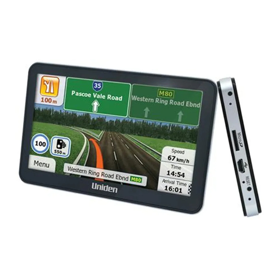
- Page 1 IGO500 IGO430 In-Car Navigation For more exciting new products please visit our website: Australia: www.uniden.com.au New Zealand: www.uniden.co.nz...
- Page 2 Thank you for purchasing this Uniden product. Read the Quick Start Guide first and start using your device right away. This document is the detailed description of the navigation software. You can easily discover your device while you are using it;...
-
Page 3: Table Of Contents
Table of Contents What Do I Do First? Make Sure These Items Arrived in the Box Plug it in Hardware Keys How Do I Put It in My Car? Safety considerations Attaching the Windshield Mount Adjusting the Windshield Mount Mount to the Windshield Removing the Windshield Mount 1 Warnings and Safety information 2 Getting started... - Page 4 3 Navigating 3.1 Selecting the destination of a route 3.1.1 Entering an address or part of an address 3.1.1.1 Entering an address 3.1.1.2 Entering an address starting with the street name 3.1.1.3 Entering the midpoint of a street as the destination 3.1.1.4 Selecting an intersection as the destination 3.1.1.5 Selecting a town/suburb centre as the destination 3.1.1.6 Entering an address with a postal code...
- Page 5 3.4.9 Changing the road types used in route planning 3.5 Saving a location as a Favourite destination 3.6 Saving a location as an alert point 3.7 Editing an alert point 3.8 Watching the simulation of the route 4 Off-road navigation 4.1 Selecting the destination of the route 4.2 Navigating in off-road mode 5 Reference Guide...
-
Page 6: What Do I Do First
Make Sure These Items Arrived in the Box If anything listed here is missing or damaged, contact your place of purchase immediately. IGO500 or IGO430 GPS navigation device Press and hold the power button at the TOP of the device to start or resume the navigation programme. -
Page 7: Plug It In
Plug it in Connect the power adapter to the power connector on the lower left side of the device. Plug the other end into your car’s cigarette lighter (or any standard 12VDC - 24VDC outlet). Only use the power adapter that comes with your device. Any other adapter might damage the device. -
Page 8: Hardware Keys
If the device fails to operate properly, try resetting the device. Press the reset button by using the touch pen or a similar tool. LCD Display Screen LCD Display Screen *IGO500 touch-pen location is shown. IGO430 touch-pen is fitted on the windshield mount. Page 8... -
Page 9: How Do I Put It In My Car
How Do I Put It in My Car? Safety Considerations Don’t install any device where it will block your view (including your mirrors!) while you’re driving. Keep your attention on the road! Don’t try to operate or focus on any device while you’re driving. -
Page 10: Attaching The Windshield Mount
Attaching the Windshield Mount Assemble the Windshield mount. 1) Loosen the locking collar on part 2. 2) Push the ball joint of Part 1 through the locking collar into part 2. Part 1 Part 2 Locking collar Insert the bracket hook into the notches at the bottom of the device. -
Page 11: Adjusting The Windshield Mount
Adjusting the Windshield Mount Locking collar Turn the windshield mount arm to a suitable angle for mounting. Suction lock Mount on the Windshield Make sure the device does not block your view of the road or your mirrors. Once you decide where you want the device, hold the suction cup in that position, then adjust the mount so you have the best view of the device. -
Page 12: Warnings And Safety Information
1 Warnings and Safety information The navigation system helps you find your way to your destination with the built-in GPS receiver. The software does not transmit your GPS position; others cannot track you. If you accept this when first using the application, it collects usage information and GPS logs that may be used for improving the application and the quality and coverage of maps. -
Page 13: Getting Started
2 Getting started The software is optimised for in-car or pedestrian use. There is no need to use a stylus. You can use it easily by tapping the screen buttons and the map with your fingertips. When using the navigation software for the first time, an initial setup process starts automatically. - Page 14 4. Select the language and speaker used for voice guidance messages. Later you can change it in Regional settings (page 118). 5. If needed, modify the time format and unit settings. Later you can change them in Regional settings (page 118). 6.
-
Page 15: Startup Screen: The Map And Navigation Menu
After the initial setup, the Map screen appears and the device looks for GPS signal. A view of the sky is required to lock onto GPS. For the initial start this may take a few minutes. you can start using the software. This is the screen you see every time navigation starts. -
Page 16: Buttons And Other Controls On The Screen
• to start navigating on the map. The button itself is a miniature live map that shows your current position, the recommended route and the surrounding map area. Tap the button to enlarge the map to the full screen. • to stop navigation and exit the software. - Page 17 List When you need to Grab the list select from several anywhere and slide options, they appear your finger up or in a list. down. Depending on the speed of the sliding, the list will scroll fast or slow, only a bit or till the end.
-
Page 18: Using Keyboards
Virtual Alphabetic and Each key is a touch keyboard alphanumeric screen button. keyboards to enter text and numbers. 2.2.1 Using keyboards You only need to enter letters or numbers when you cannot avoid it. You can type with your fingertips on the full-screen keyboards and you can switch between various keyboard layouts, for example English, Greek or numerical. -
Page 19: Beyond Single Screen Tap
Entering numbers and symbols to switch to a keyboard offering numeric and symbol characters. Finalising the keyboard entry (accepting the suggested search result) Finalising the keyboard entry (opening the list of search results) Tap Finalising the keyboard entry (saving your input) Cancelling the keyboard entry (returning to the previous screen) 2.2.2 Beyond single screen tap... -
Page 20: Map Screen
Gestures You need to drag and drop the screen only in cases like: (drag&drop) • Moving the handle on a slider. • Scrolling the list: grab the list anywhere and slide your finger up or down. Depending on the speed of the sliding, the list will scroll fast or slow, only a bit or till the end. - Page 21 When GPS position is available, the Vehimarker is displayed in full colour, now showing your current position. There are screen buttons and data fields on the screen to help you navigate. During navigation, the screen shows route information. By default, only one data field is displayed in the bottom right corner. Tap this field to see all route data fields.
-
Page 22: Position Markers
Field Description Shows your current speed given by the GPS receiver. Shows the speed limit of the current road if the map contains it. Shows the current time corrected with time zone offset. The accurate time comes from the GPS satellites, and the time zone information comes from the map or it can be set manually in Regional settings. -
Page 23: Selected Map Location (Cursor) And Selected Map Object
The exact location of the Vehimarker depends on the vehicle type used for route calculation. The vehicle type can be selected in Route settings (page 107). • If you choose pedestrian: The Vehimarker is at your exact GPS position. The direction of the icon shows your current heading. -
Page 24: Turn Preview And Next Street
2.3.3.2 Turn preview and Next street When navigating a route, the top section of the Map screen shows information about the next route event (manoeuvre) and the next street or the next city/town. There is a field in the top left corner that displays the next manoeuvre. Both the type of the event (turn, roundabout, exiting motorway, etc.) and its distance from the current position is displayed. -
Page 25: Lane Information And Signposts
Turn sharp left. Keep left. Continue straight in the intersection. Go left on the roundabout, 3rd exit (next manoeuvre). Enter roundabout (second next manouvre). Enter motorway. Exit motorway. Board ferry. Leave ferry. Approaching a waypoint. Approaching the destination. 2.3.3.3 Lane information and Signposts When navigating on multilane roads, it is important to take the appropriate lane in order to follow the recommended route. -
Page 26: Junction View
to the lane(s) to be taken; all others are darker. 2.3.3.4 Junction view If you are approaching a motorway exit or a complex intersection and the needed information exists, the map is replaced with a 3D view of the junction. The lanes you need to take are displayed with arrows. -
Page 27: Object Types
2.3.3.6 3D object types Your software supports the following 3D object types: Type Description 3D terrain 3D terrain map data shows changes in terrain, elevations or depressions in the land when you view the map in 2D, and use it to plot the route map in 3D when you navigate. -
Page 28: Elements Of The Active Route
2.3.3.7 Elements of the active route Your software shows the route in the following way: Symbol Name Description Current GPS Your current position displayed on the map. position and • In pedestrian mode it is the exact GPS position. Start point •... - Page 29 Action Button(s) Description Moving the No buttons You can move the map in any direction: tap and map with hold the map, and move your finger towards the drag&drop direction you want to move the map. Zooming in Changes how much of the map is displayed on the and out screen.
-
Page 30: Quick Menu
Rotating left Changes the horizontal view angle of the map. and right Tap the button once to modify the view in large steps, or tap and hold the button to modify it continuously and smoothly. 2D or 3D Tap this button to switch between the 3D view perspective and 2D top-down map view modes. - Page 31 The menu will close after a few seconds of inactivity or if you tap The menu will also close if you initiate simple controls like muting the device. In other cases tapping a button will open a new screen with options. Most of these functions are shortcuts.
- Page 32 Tap this button to select one of your Find / Favourite (page Favourite destinations. Tap this button to select one of your Find / History (page previous destinations in the History list. Tap this button to edit the route. My Route / Edit Route Tap this button to change route More / Settings / Route related settings.
- Page 33 This function opens the Visual More / Settings / Visual Guidance settings screen. Guidance (page 115) This function lets you bypass parts of My Route / Avoidances the recommended route. This function opens the Trip Monitor More / Trip Monitor screen where you can manage your (page 101) previously saved trip logs and track...
-
Page 34: Checking The Details Of The Current Position (Where Am I?)
2.3.6 Checking the details of the current position (Where Am I?) This screen contains information about the current position (or about the last known position if GPS reception is not available) and a button to search for useful Places nearby. You can access this screen from the map in one of the following ways: •... - Page 35 You can also perform some actions on this screen: to save the current position as a Favourite destination. You can search for assistance near your current position. Tap to open a new screen for the Quick search: The following services can be searched around the current position or the last known position: •...
-
Page 36: Navigating
3 Navigating When first started, the software calculates routes using the road network of the high quality vector maps provided with the product. You can set up your route in different ways: • If you need a route for immediate navigation, you can select the destination and start navigating to it right away (normal navigation). -
Page 37: Entering An Address Or Part Of An Address
3.1.1 Entering an address or part of an address If you know at least a part of the address, it is the quickest way to select the destination of the route. Using the same screen, you can find an address by entering: •... - Page 38 a. Tap . The town/suburb of your current location is offered by default. For a local search, tap to accept it, otherwise continue with entering the destination town/suburb name. b. Start entering the name of the town/suburb on the keyboard. c.
- Page 39 results before it appears automatically, tap ). Select the street from the list. 6. Enter the house number: a. Tap b. Enter the house number on the keyboard. (To enter letters, tap c. Tap to finish entering the address. (If the entered house number cannot be found, the midpoint of the street is selected as the destination.) 7.
-
Page 40: Entering An Address Starting With The Street Name
to modify route parameters, or tap and start your journey. If you know that you will use this destination frequently, before tapping to confirm the destination, put it on the list of your Favourites first: tap then , give a name for the new Favourite, and tap to save the location. - Page 41 4. Enter the street name: a. Tap b. Start entering the street name on the keyboard. c. Find the street you need: • The most likely street name is always shown in the input field. To accept it, tap • If the desired name does not show up, the names that match the string appear in a list after entering a couple of characters (to open the list of results before it appears automatically, tap...
-
Page 42: Entering The Midpoint Of A Street As The Destination
6. A full screen map appears with the selected point in the middle. If necessary, tap the map somewhere else to modify the destination. The Cursor ( appears at the new location. Tap to confirm the destination, or tap to select a different destination. 7. - Page 43 a. Tap b. Start entering the street name on the keyboard. c. Find the street you need: • The most likely street name is always shown in the input field. To accept it, tap • If the desired name does not show up, the names that match the string appear in a list after entering a couple of characters (to open the list of results before it appears automatically, tap ).
-
Page 44: Selecting An Intersection As The Destination
to select a different destination. 7. After a short summary of the route parameters, the map appears showing the entire route. The route is automatically calculated. Tap to modify route parameters, or tap and start your journey. 3.1.1.4 Selecting an intersection as the destination To enter an address as the destination, do as follows: 1. - Page 45 string appear in a list after entering a couple of characters (to open the list of results before it appears automatically, tap ). Select the street from the list. 5. Enter the intersecting street name: a. Tap • If only a few intersecting streets exist, their list appears immediately. •...
-
Page 46: Selecting A Town/Suburb Centre As The Destination
entire route. The route is automatically calculated. Tap to modify route parameters, or tap and start your journey. 3.1.1.5 Selecting a town/suburb centre as the destination The town/suburb centre is not the geometric centre of the settlement but an arbitrary point the map creators have chosen. - Page 47 5. Instead of entering the street name, tap . This way the centre of the displayed town/suburb becomes the destination of the route. 6. A full screen map appears with the selected point in the middle. If necessary, tap the map somewhere else to modify the destination. The Cursor ( appears at the new location.
-
Page 48: Entering An Address With A Postal Code
3.1.1.6 Entering an address with a postal code All of the above address searching possibilities can be performed with entering the postal code instead of the settlement name. Find below an example with a full address: 1. If you are on the Map screen, tap to return to the Navigation menu. - Page 49 5. Enter the street name: a. Tap b. Start entering the street name on the keyboard. c. Find the street you need: • The most likely street name is always shown in the input field. To accept it, tap • If the desired name does not show up, the names that match the string appear in a list after entering a couple of characters (to open the list of results before it appears automatically, tap...
-
Page 50: Tips On Entering Addresses Quickly
7. A full screen map appears with the selected point in the middle. If necessary, tap the map somewhere else to modify the destination. The Cursor ( appears at the new location. Tap to confirm the destination, or tap to select a different destination. 8. -
Page 51: Selecting The Destination From The Places Of Interest
• After entering a couple of letters, tap to list the items that contain the specified letters. • You can speed up finding an intersection: • Search first for the street with a less common or less usual name; fewer letters are enough to find it. -
Page 52: Quick Search For A Place Of Interest
3.1.2.1 Quick search for a Place of Interest The Quick search feature lets you quickly find a Place by its name. The search is always carried out • along the recommended route if it exists or • around your current location if there is no destination given. 1. -
Page 53: Searching For A Place Of Interest Using Preset Categories
4. (optional) The Places in the list are ordered by the length of the necessary detour (when navigating a route) or by their distance from the current position (when no destination is given). If you need to reorder the list, tap 5. - Page 54 1. If you are on the Map screen, tap to return to the Navigation menu. 2. In the Navigation menu, tap the following buttons: 3. The preset search categories appear: • • If an active route exists, petrol stations are searched along the route. •...
- Page 55 • If there is no active route (destination is not selected), they are searched around the current position. • If the current position is not available either (no GPS signal), they are searched around the last known position. • • If an active route exists, accommodation is searched around the destination of the route.
-
Page 56: Searching For A Place Of Interest By Category
8. If necessary, tap the map somewhere else to modify the destination. The Cursor ( ) appears at the new location. Tap to confirm the destination, or tap to select a different destination. 9. After a short summary of the route parameters, the map appears showing the entire route. - Page 57 • to search for a place within a selected city or town. (The result list will be ordered by the distance from the centre of the selected city/town.) • to search for a place around the destination of the active route.
- Page 58 7. Select one of the Place subcategories (e.g. Hotel or Motel) or tap to list all Places in the selected main category around the selected location or along the route. 8. Sometimes the list of brands in the selected Place subcategory appears. Select one brand or tap to list all Places in the selected subcategory around the selected location or along the route.
- Page 59 10. (optional) The Places in the list are ordered by their distance from the current or last known position, from the selected town/suburb, from the destination or by the length of the necessary detour. If you need to reorder the list, tap 11.
-
Page 60: Searching For A Place Of Interest By Name
3.1.2.4 Searching for a Place of Interest by name You can search for Places of Interest by their names. You can search around different locations or along your route in the whole Place database or in one Place category or subcategory only. 1. - Page 61 5. (optional) If you have selected , select the city/town to search in. 6. Tap to search in all Places, or select one of the main Place categories (e.g. Accommodation) to search in. 7. Tap to search in the selected Place category or select one of the Place subcategories (e.g.
- Page 62 8. Tap if you have not done it before. 9. Using the keyboard, start entering the name of the Place. 10. After entering a few letters, tap to open the list of Places with names containing the entered character sequence. 11.
-
Page 63: Selecting Nearby Assistance From 'Where Am I
13. (optional) Tap to see the details of the selected Place. Tap return to the map. 14. If necessary, tap the map somewhere else to modify the destination. The Cursor ( ) appears at the new location. Tap to confirm the destination, or tap to select a different destination. - Page 64 2. Tap , and then 3. The Quick search categories appear, all for searching around the current position (or around the last known position if the current position is not available): • : Car repair and roadside assistance services • : Medical and emergency services •...
-
Page 65: Selecting A Map Location As The Destination
6. Browse the list if necessary and tap one of the list items. A full screen map appears with the selected point in the middle. The name and address of the Place is displayed at the top of the screen. 7. -
Page 66: Selecting The Destination From Your Favourites
4. Tap the location that you want to select as your destination. The Cursor ( appears. 5. Tap to select the Cursor as the destination. 6. After a short summary of the route parameters, the map appears showing the entire route. The route is automatically calculated. Tap modify route parameters, or tap and start your journey. - Page 67 • If you are in the Navigation menu, tap and then tap The list of Favourite destinations is displayed. 3. Tap the Favourite that you want to set as your destination. If necessary, browse down to see more of the list or tap and enter a few letters from the name of the Favourite destination.
-
Page 68: Selecting The Most Likely Destination (Smart History)
3.1.5 Selecting the most likely destination (Smart History) The destinations that you have set earlier appear in the History list. Two of those recent destinations are shown in the Destination menu for easy access. Smart History offers these locations based on your navigation habits, using parameters like the current time of day, the day of week, and the current location. -
Page 69: Selecting The Destination From The History
3.1.6 Selecting the destination from the History The destinations that you have set earlier appear in the History. 1. Access the History: • If you are on the Map screen, tap and then tap • If you are in the Navigation menu, tap and then tap 2. -
Page 70: Entering The Coordinate Of The Destination
to select a different destination. 5. After a short summary of the route parameters, the map appears showing the entire route. The route is automatically calculated. Tap modify route parameters, or tap and start your journey. 3.1.7 Entering the coordinate of the destination You can also select a destination by entering its coordinate. -
Page 71: Navigate To A Location Stored In A Photo
coordinate in UTM format. When finished, tap 7. A full screen map appears with the selected point in the middle. If necessary, tap the map somewhere else to modify the destination. The Cursor ( appears at the new location. Tap to confirm the destination, or tap to select a different destination. -
Page 72: Building The Route From The List Of Destinations (Create Route)
3. Open the tab and tap 4. The list of photos stored in the device appears. Select one photo from the list. 5. A full screen map appears with the selected point in the middle. If necessary, tap the map somewhere else to modify the destination. The Cursor ( appears at the new location. - Page 73 4. There is only one line in the list of route points, the start point of the route, normally the current GPS position. 5. Tap to select the destination. 6. The Destination menu appears and you can select the destination of the route the same way as described in the previous sections.
-
Page 74: Viewing The Entire Route On The Map
3.2 Viewing the entire route on the map It is easy to get a map overview of the active route. Do as follows: 1. If you are on the Map screen, tap to return to the Navigation menu. 2. In the Navigation menu, tap 3. -
Page 75: Modifying The Route
• The route planning method (e.g. Fast). 4. You have the following options on this screen (for detailed instructions on how to use them, see the next chapter): • to edit the route: to add or remove destinations or change their sequence. -
Page 76: Setting A New Starting Position For The Route
• to plan a new route to the newly selected location. The previous destination and waypoint(s) are deleted. • to add the newly selected location as an intermediate destination to your route. The other destinations of the route remain intact. Note: the new waypoint is placed among destinations to keep the route optimal. - Page 77 4. The first line is the start of the route, normally the current GPS position. and confirm your action at the warning message. 5. The Destination menu appears and you can select the start point of the route the same way you select a destination. 6.
-
Page 78: Editing The List Of Destinations (Edit Route)
7. The map returns with a transparent Vehimarker (showing that there is no GPS reception). If an active route already existed, it is now recalculated starting from the selected location. 8. To return to normal navigation, tap 3.4.3 Editing the list of destinations (Edit Route) You can edit the route by modifying the list of destinations. -
Page 79: Pausing The Active Route
• to modify the start point of the route. • to reorder the list. You can do it manually or you can let the application optimise the route for you. 3.4.4 Pausing the active route You do not need to pause the active route: when you start driving again, the software restarts the voice instructions from your position. - Page 80 3. Tap 4. You see the basic details of three route alternatives with the selected route planning method. Tap any of them to see it on the map. 5. Or if you cannot find a good alternative, tap and scroll down for routes with different routing methods.
- Page 81 3.4.7 Changing the route planning method (route alternatives) To recalculate the active route with a different route planning method, you can modify the Route settings (page 106). Another way for this is to compare these alternatives. Do as follows: 1. If you are on the Map screen, tap to return to the Navigation menu.
-
Page 82: Changing The Vehicle Used In Route Planning
6. Or if you cannot find a good alternative, tap and scroll down for routes with different routing methods. 7. Select one of the route alternatives then tap and hold for a few seconds to return to the Map screen. The software recalculates the route. The orange line now shows the new recommended route. -
Page 83: Changing The Road Types Used In Route Planning
2. Tap , and then tap one of the following: • • • • • • 3. The software recalculates the route optimised for the new vehicle type. The orange line now shows the new recommended route. If you select and you forget to change it back to a vehicle later, the software warns you when you travel with a speed that is too high for a pedestrian. -
Page 84: Saving A Location As A Favourite Destination
2. Tap any of the listed road types to modify the route. If needed, scroll the list for all road types. You have the following options (their order depends on the selected vehicle type): • - You might need to avoid motorways when you are driving a slow car or you are towing another vehicle. -
Page 85: Saving A Location As An Alert Point
3. Tap 4. (optional) Using the keyboard, you can change the name offered for the Favourite. Tap to enter numbers or symbols. 5. Tap to save the location as a new Favourite destination. 3.6 Saving a location as an alert point You can save any map location as an alert point (for example a speed camera or a railway crossing). -
Page 86: Editing An Alert Point
3. Scroll down the list and tap 4. On the newly opened screen, select the type of the alert point, the direction from which you expect the alert, and (if applicable) the speed limit for this alert point. 5. Tap to save the location as a new alert point. -
Page 87: Watching The Simulation Of The Route
3. Scroll down the list and tap 4. On the newly opened screen, modify the type of the alert point, the direction from which you expect the alert, or (if applicable) the speed limit for this alert point. 5. Tap to save the changes to the alert point. - Page 88 4. Scroll down the list and tap . The simulation starts from the starting point of the route, and using a realistic speed, it leads you through the whole recommended route. 5. (optional) You have the following controls during the simulation (the control buttons disappear after a few seconds but you can open them again if you tap the map): •...
-
Page 89: Off-Road Navigation
4 Off-road navigation When first started, the software calculates routes using the road network of the high quality vector maps provided with the product. You can switch the application to off-road mode in Navigation settings in one of the following ways: •... - Page 90 You see a orange line drawn between your current position and the next destination to reach. The Turn Preview field in the top left corner shows a compass with your bearing and the distance of the next destination. When you reach a waypoint, the orange line will show the direction to the next destination.
-
Page 91: Reference Guide
5 Reference Guide On the following pages you will find the description of the different concepts and menu screens of the software. 5.1 Concepts 5.1.1 Smart Zoom Smart Zoom provides much more than just a usual automatic zoom feature: • While following a route: when approaching a turn, it will zoom in and raise the view angle to let you easily recognise your manoeuvre at the next junction. -
Page 92: Route Calculation And Recalculation
The top-down overview of the tunnel helps you orientate yourself. The remaining distance in the tunnel is also displayed. After leaving the tunnel, the original map view returns. This feature can be turned off in Settings (page 85). 5.1.4 Route calculation and recalculation Your software calculates the route based on your preferences: •... - Page 93 • Vehicle types: • • Manoeuvre restrictions and directional constraints are taken into account when planning a route. • Roads are used only if access for cars is allowed. • Private roads and resident-only roads are used only if they are inevitable to reach the destination.
- Page 94 • • All manoeuvres are available in intersections. • Directional constraints are taken into account the way that opposite direction is allowed with a low speed. • A private road is used only if the destination is there. • Walkways are excluded from routes. •...
-
Page 95: Green Routing
• • Whenever data exists, route calculation takes into account statistical traffic data for the given day of week and time of day. Your software automatically recalculates the route if you deviate from the proposed itinerary. For further information about Route settings, see page 106. 5.1.5 Green routing Route calculation is not only about finding the quickest or shortest route. -
Page 96: Road Safety Cameras And Other Proximity Alerts Points
If the selected route planning method is not Green, and you have allowed the application to show the green alternative, the price, fuel consumption and CO emission differences between your selected route and the Green route are also shown on this screen: Tap the field with these details to switch the route to Green immediately. -
Page 97: Speed Limit Warning
• Visual warning: the type of the alert point, its distance and the related speed limit appear on the Map screen while you are approaching one of these cameras. The distance from the camera is also displayed. For some of the alert points, the enforced or expected speed limit is available. For these points, the audio alert can be different if you are below or above the given speed limit. -
Page 98: Battery And Gps Position Quality Indicators
5.1.8 Battery and GPS position quality indicators You can find useful information in the top corners of menu screens. The battery symbol in the top left corner, next to the current time shows information about the rechargeable battery of the device. Icon Description The battery is charging. -
Page 99: Traffic Information In Route Planning
Altitude information is available, the position is a 3D position. GPS navigation is possible. 5.1.9 Traffic information in route planning The function is subject to data availability. The recommended route is not always the same between two points. Offline statistical traffic information (historical speed information or traffic patterns) can be taken into account in the route calculation based on the time of day and the day of week whenever suitable data exists. -
Page 100: More' Menu
5.2 ‘More’ menu The ‘More’ menu provides you with various options and additional applications. Tap the following buttons: Button Description You can configure the program settings, and modify the behaviour of the software. Fine-tune route planning options, change the look of the Map screen, turn on or off warnings, or restart the Configuration wizard, etc. - Page 101 The scientific calculator helps you in all your calculation needs. Tap the Mode button for additional functions and use the memory to save your results. The Fuel consumption monitor helps you keep track of the consumption of your car even if you do not use navigation for all your journeys.
-
Page 102: Settings Menu
5.3 Settings menu You can configure the program settings, and modify the behaviour of the software. Tap the following buttons: The Settings menu has several options. Tap or scroll with your finger to see the full list. Button Description Adjust the sound volume, mute your device or change the voice guidance language. -
Page 103: Sound And Warnings
Settings related to guidance on the map screen can be adjusted here. Display related settings include menu animations, separate skins for daytime and night use and the brightness of the display. These settings allow you to customise the application for your local language, measurement units, time and date settings and formats, as well as to choose the time zone. - Page 104 This button shows the current voice guidance profile. By tapping the button, you can select a new profile from the list of available languages and speakers. Tap any of these to hear a sample voice prompt. Just tap when you have selected the new spoken language.
- Page 105 Maps may contain information about the speed limits of the road segments. The software is able to warn you if you exceed the current limit. This information may not be available for your region (ask your local dealer), or may not be fully correct for all roads in the map.
- Page 106 You can set the alert for the different alert point categories individually. The following alert types are available: • Audio warning: beeps can be played (natural voice) or the type of the alert can be announced (TTS) while you are approaching one of these points, and an extra alert can warn you if you exceed the given speed limit while approaching.
-
Page 107: Customise Quick Menu
Turn off the attention tone preceding verbal instructions or adjust its volume. These controls affect the volume of the alert sounds (beeps). Key sounds provide audible confirmation of either pressing hardware buttons or tapping the touch screen. These controls affect key sounds. Controls for each sound type: Button Description... - Page 108 On-road navigation creates a turn by turn itinerary using the road network on the map. Switch to off-road navigation to navigate between destinations in a straight line. The route calculation can be optimised for different situations and vehicle types by changing the planning method. See below for details.
- Page 109 The software includes ferries in a planned route by default. However, a map does not necessarily contain information about the accessibility of temporary ferries. You might also need to pay a fare on ferries. The software excludes unsealed roads by default: unsealed roads can be in a bad condition and usually you cannot reach the speed limit on them.
- Page 110 Button Description Tap this button to rename the profile for something meaningful. Enter the average consumption of your vehicle when used in built-up areas. The unit for consumption can be set in Regional Settings. Enter the average consumption of your vehicle when used on highways.
- Page 111 Select one or more hazard types if the vehicle carries Freight dangerous material. Vehicle types: • • Manoeuvre restrictions and directional constraints are taken into account when planning a route. • Roads are used only if access for cars is allowed. •...
- Page 112 • Speed limits are not used in route calculation and an average cycling speed is used when calculating the estimated time of arrival. • • All manoeuvres are available in intersections. • Directional constraints are taken into account the way that opposite direction is allowed with a low speed.
-
Page 113: User Profiles
Gives a quick but fuel efficient route based on the fuel consumption data given in Green Routing settings (page 95). Travel cost and emission calculations are estimations only. They cannot take elevations, curves and traffic conditions into account. For vehicle types where Green routing is not available, this method combines the benefits of Fast and Short: The software calculates as if it were calculating the Fast route, but it takes other roads as well to save fuel. -
Page 114: Map Settings
5.3.5 Map settings You can fine-tune the appearance of the Map screen. Adjust the map view to your needs, choose suitable colour themes from the list for both daytime and night use, change the blue arrow to a 3D car model, show or hide 3D buildings, turn track logging on or off, and manage you Place visibility sets (which Places to show on the map). - Page 115 Replace the default position marker to one of the 3D vehicle models. You can select separate icons for different vehicle types selected for route planning. Separate icons can be used for car, pedestrian and the other vehicles. Show or suppress 3D landmarks, 3D artistic or block representations of prominent or well-known objects.
-
Page 116: Visual Guidance Settings
5.3.6 Visual guidance settings Settings related to guidance on the map screen can be adjusted here. The data fields in the corner of the Map screen can be customised. Tap this button and select the values you want to see. The values can be different when you navigate a route from when you are just cruising without a given destination. - Page 117 When you slow down while driving on a motorway, there is a chance that you are in a traffic jam so the software offers you a detour using the next exit. The message shows you distance of the exit and the difference in distance and estimated time compared to the original route.
-
Page 118: Display Settings
If you leave the recommended route and suddenly exit the motorway, the application offers different alternatives near the exit like petrol stations or restaurants. Also, if there are avoidable parts of the original route ahead (like a tunnel, a toll road or a ferry), you will find them in the list in case you want to bypass them with the help of the software. -
Page 119: Trip Monitor Settings
You can set the distance units to be used by the program. Your software may not support all the listed units in some voice guidance languages. Select between 12 and 24 hours time display and the various international date display formats. By default, time zone is taken from the map information and adjusted by your current location. - Page 120 5.3.10 Log Collection settings If you accept this when first using the application, it collects usage information and GPS logs that may be used for improving the application and the quality and coverage of maps. The data is processed anonymously; no one will be able to track any personal information.
-
Page 121: Glossary
6 Glossary 2D/3D GPS reception The GPS receiver uses satellite signals to calculate its (your) position and needs at least four signals to give a three-dimensional position, including elevation. Because the satellites are moving and because objects can block the signals, your GPS device might not receive four signals. - Page 122 You can use digital maps interactively: you can zoom in and out (increase or decrease the scale), you can tilt them up and down, and rotate them left and right. In GPS-supported navigation, digital maps facilitate route planning. North-up map orientation In North-up mode the map is rotated so its top always faces North.
-
Page 123: End User Licence Agreement
7 End User Licence Agreement 1 The contracting parties 1.1 This Agreement has been entered into by and between Nav N Go Kft. (registered seat: 23 Bérc utca, H-1016 Budapest, Hungary; Company reg.no.: 01- 09-891838) as Licensor (hereinafter: Licensor) and You as the User (hereinafter: User;... - Page 124 4.2 The Software Product shall include the operating computer program, its complete documentation, the map database pertaining thereto and any third- party content and services accessible through the Software Product (hereinafter: Database). 4.3 Any form of display, storage, coding, including printed, electronic or graphic display, storage, source or object code, or any other as yet undefined form of display, storage, or coding, or any medium thereof shall be deemed parts of the Software Product.
- Page 125 thereon. 6.2 The User undertakes and accepts that the Software Product and/or its certain elements and/or contents provided by third parties may require separate action (registration/activation) within the time period specified in the Software product to achieve its partial or full functionality. 6.3 The User is entitled to make one backup copy of the Software Product.
- Page 126 7.2 The User acknowledges that the Software Product may prohibit or block partly or completely the use of the Software Product and/or its parts and/or third party contents if the separate action (activation/registration) as specified in Section 6 is not met within the time defined in the Software Product. 7.3 The User may only use the contents available through the Software Product and provided by third parties for his/her own personal benefit and at his/her own risk.
- Page 127 responsibility for any damages occurred in relation to use of the Software Product in a motor vehicle. 8.6 By concluding the Agreement, the User shall, in particular, acknowledge the information stated in Section 8 above. 9 Sanctions 9.1 The Licensor hereby informs the User that, if the Licensor finds its rights under the Copyright Act to be breached, the Licensor may 9.1.1 seek judicial recognition of this breach;...
- Page 128 The relevant information and data in connection with the contents and services provided by third parties are available at www.navngo.com. The User hereby acknowledges that the contents and services provided by third parties may only be used at the risk of the User and for the personal benefit of the User. 9.4 Contents and services provided by the Licensor or an agent of the Licensor The Licensor or a contractual partner may offer various products and services to the User through www.naviextras.com.
-
Page 129: Limited One Year Warranty
(1) year from the date of the original retail sale. If a warranty claim is made, this warranty will not apply if the Product is found by Uniden to be: (A) Damaged or not maintained in a reasonable manner or as recommended in the relevant Uniden Owner’s Manual;... - Page 130 Product, together with satisfactory evidence of your original purchase (such as a legible copy of the sales docket) to Uniden at the addresses shown below. You should contact Uniden regarding any compensation that may be payable for your expenses incurred in making a warranty claim.
- Page 131 Notes Page 131...
- Page 132 ThaNk you for buyINg a uNIdeN produCT. © 2012 Uniden Australia Pty Limited. Uniden New Zealand Ltd. Printed in PRC.
Need help?
Do you have a question about the IGO500 and is the answer not in the manual?
Questions and answers