DeLorme Earthmate GPS PN-20 User Manual
Hide thumbs
Also See for Earthmate GPS PN-20:
- User manual (98 pages) ,
- Getting started manual (6 pages) ,
- Quick start manual (2 pages)
Table of Contents
Advertisement
Quick Links
We Bring Technology Down to Earth
™
Since its incorporation in 1976, DeLorme has developed an unprecedented reputation as a leader in the mapping industry. From early beginnings as a paper
atlas publisher, the company quickly emerged as a pioneering technological innovator. DeLorme not only embraced new technologies, it developed them.
In the mid-1990s, before GPS usage was widespread, DeLorme was pioneering laptop GPS solutions that today include the popular Earthmate GPS LT-20.
Subsequent development led to industry-first GPS solutions for Pocket PC and Palm OS devices and more recently for Bluetooth GPS solutions.
For more information, visit www.delorme.com.
D
LORME
E
Earthmate GPS PN-20
An All-in-One Handheld GPS Solution from DeLorme, the Leading
Digital Mapping and GPS Company
®
User Manual
Advertisement
Table of Contents

Related Manuals for DeLorme Earthmate GPS PN-20


Summary of Contents for DeLorme Earthmate GPS PN-20
- Page 1 ™ Since its incorporation in 1976, DeLorme has developed an unprecedented reputation as a leader in the mapping industry. From early beginnings as a paper atlas publisher, the company quickly emerged as a pioneering technological innovator. DeLorme not only embraced new technologies, it developed them.
-
Page 2: Table Of Contents
GPS PN-20 Accessories ® Getting Started ........................2 We offer a variety of products designed to help you get the most out of your Earthmate GPS PN-20. Basic Functions ........................9 For more information, be sure to visit www.delorme.com/pn20. Scenarios ..........................11 The Satellites Page ...................... -
Page 3: Getting Started
Getting Started Getting Started To turn off the Earthmate GPS PN-20, press the Power button and then press the ENTER button to confirm you want to turn the Earthmate GPS PN-20 off. Thank you for purchasing the DeLorme Earthmate GPS PN-20. This versatile and compact GPS Step 3 —... - Page 4 The Mark button is labeled with a push pin and can be used to mark a waypoint at your current GPS PN-20 off. If you do not wish to turn the Earthmate GPS PN-20 off, wait five seconds or press location or the cursor location (if panning).
- Page 5 The data from these three satellites provides the receiver with a two-dimensional location. This manual describes all of the functionality found in each Page on the Earthmate GPS PN-20. See Data acquired from a fourth satellite pinpoints the receiver’s exact location. This additional position- the Table of Contents to find the headings that are most important to you.
-
Page 6: Basic Functions
DeLorme does not guaran- (by highlighting the waypoint tee compatible operation. • You are tracking with the Earthmate GPS PN-20 when the GPS is on, but a route is not being information, pressing ENTER, and then modifying the infor- followed. -
Page 7: Scenarios
Once they find a cache, they use Topo USA to see the geocache on the map and then download a on while connected. If you want to use the Earthmate GPS PN-20 while it is charging, it must be map package of the area. - Page 8 Once they arrive at the cache, they take a trinket from the cache and leave a pencil they bought while Bird Watching on a recent trip to Niagara Falls and then update the waypoint symbol on the Earthmate GPS PN-20 Earthmate GPS PN-20 is a perfect companion while bird watching. With PN-20 Aerial Data Packet to the geocache found symbol.
- Page 9 17. Press the Power button to turn the Earthmate GPS PN-20 off. Press ENTER when prompted. he arrives at the location he parks his truck, turns on the Earthmate GPS PN-20, waits until he gets Once he’s finished for the day, he turns the GPS device back on, waits until he gets a 2-D or 3-D fix, a 2-D or 3-D fix, places a waypoint to represent the parking lot, modifies his tracking settings, and and then follows his track to where he started-ensuring that he won’t get lost.
-
Page 10: The Satellites Page
6. Press PAGE until the Map Page displays to view the location in real time. you of your current GPS status, the number of satellites the Earthmate GPS PN-20 is acquiring data The GPS device not only tells them where they are in real-time, but also keeps a record (track) of from, the signal strength, and the GPS accuracy (only available when a 2-D or 3-D fix is obtained). - Page 11 There are many features on the Earthmate GPS PN-20 that do not require a GPS fix. You can turn the • Red—Indicates your GPS receiver is tracking the satellite, but it is not receiving data from it.
-
Page 12: The Map Page
Note: If Show Info Fields displays in the list, the information fields are already hidden. Choose • A flashing red arrow indicates that the Earthmate GPS PN-20 cannot obtain a GPS signal. Show Info Fields to display the information fields. - Page 13 Battery Life Displays the percentage of battery power that is left on the Earthmate GPS PN-20. ETA at Next Stop The Estimated Time of Arrival at the next stop in the route (expressed as hours:minutes AM/PM). ETA is based on the...
- Page 14 The Map Page Information Field Option Description Information Field Option Description Next Turn The label of the next turn, as it appears in the route directions. Time to Finish The calculated time to the route finish based on road class- A symbol displays the direction of the turn/route direction ifications and default speed settings.
- Page 15 Prioritizing Your Data Next Turn, Dist to Finish, Time to Turn, Dist to Turn Since many different data types can be used on the Earthmate GPS PN-20, you can prioritize the data (when navigating) layers that you want to display on the map using the Data Layering menu option. Data layers with a Use the steps below to reset the information fields to their default settings.
- Page 16 Press QUIT to return to the Data Management screen. loaded on the Earthmate GPS PN-20. The data type at the top of the list has the highest priority. 6. If the check box next to the map is selected and you want to hide the map from view, press The data type at the bottom of the list has the lowest priority.
- Page 17 Changing the Level of POI Detail Restoring the Default Settings in the Map Setup Screen The Map Page Several compatible data types contain points of interest (such as trails, mountains, accommodations, The Map Setup screen also offers a Restore Defaults option which allows you to change any of the restaurants, etc.) that display as symbols on the map.
-
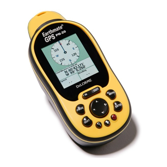
Page 18: The Compass Page
(following a route) or tracking. fields display if the Earthmate GPS PN-20 is in large text mode). Each field is customizable with one of the many available information field options (see pages 22-25 for a table that contains all of the The compass rotates so that the heading is always up. -
Page 19: The Find Page
To Reset the Trip Information The Find Page The Find Page Use the Reset Info option in the Trip Info menu if you want to start a new trip and reset the odometer, Using the Find Page speed information, and/or elevation information. Tip: Interested in seeing how Notes: You can use the Find button (the button that displays with a magnifying glass) to search for addresses,... - Page 20 ENTER. A confirmation message displays. Use the arrow keypad to highlight the OK button and Topo USA data will pro- the letters you enter with the keyboard. Then, highlight OK and then press ENTER. and then press ENTER to delete the waypoint from the Earthmate GPS PN-20. vide more geographic feature results).
- Page 21 The Find Page To create a route from your current location to the search result, use the arrow keypad to high- ments. Press ENTER once you’ve edited each group of information. light the Route button and then press ENTER. Use the arrow keypad to update the route name, Note: Not all map data types add another point to the route, and to select a calculation method.
- Page 22 The Find Page 9. To search within a country other than the U.S., use the arrow keypad to highlight the Country want to change and use the keypad again to move the letter/number up or down. field and then press ENTER. Enter the country name by highlighting each letter of the country’s 5.
- Page 23 The Find Page you enter with the keyboard. Then, highlight OK and then press ENTER. If your current Find setting is Find By Name and you want to search for cities that are near the Note: If you want to search for all cities within a state, leave the City field blank. map center, use the arrow keypad to select the Find Near Map Center option.
-
Page 24: The Waypoints Page
You can use the Mark button (the button that displays as a push pin) on Earthmate GPS PN-20 to 8. To save the waypoint to the Earthmate GPS PN-20, use the arrow keypad to highlight the Save ment. - Page 25 Use the arrow keypad to highlight the Yes button and then press ENTER to Press ENTER when finished. delete the waypoint from the Earthmate GPS PN-20. AND/OR To change the date and time the waypoint was added, use the arrow keypad to highlight the Time/Date field and then press ENTER.
-
Page 26: The Routes Page
7. Use the arrow keypad to highlight the Calculation Method drop-down list and press ENTER. Tip: To exit Navigation Mode, There are many ways to create routes on the Earthmate GPS PN-20. You can create a route: Then, highlight the desired calculation method (Road or Direct) and press ENTER again. - Page 27 The Routes Page Note: To select a route point that is on the map, highlight the Use Map button and press 4. Press MENU. ENTER to pan to the location on the map that you want to use as a route point. Once you move 5.
-
Page 28: The Tracks Page
6. To view the track, highlight the View button and then press ENTER. Note: The View button Tip: Select to enter more Earthmate GPS PN-20 is set to record GPS tracks by default. That means that the device will create a toggles with the Hide button. than one line of text in a com- track (“breadcrumb trail”) of your travels until you turn recording off. - Page 29 To View a Saved Track To Delete All Saved Track Logs The Tracks Page 1. Ensure the Tracks Page is displaying. You can use the Track menu to delete all of the track logs you have saved on your device. 2.
-
Page 30: The Sun/Moon Page
The Sun/Moon Page The Sun/Moon Page The graphic on the left shows the current position of the sun/moon (in relation to a compass). The gray bar represents the sun’s shadow. The graphic on the right shows where the sun/moon currently Using the Sun/Moon Page is as it moves from east to west. -
Page 31: The Tide Page
The Device Setup Page Using the Tide Page The Device Setup Page options let you modify the default settings on the Earthmate GPS PN-20 such as the battery type, backlight settings, and more. Use the Tide Page to view high and low tide information based on a specific time, date, and tide Tip: When viewing the Device station. - Page 32 Mass Storage: SD/MMC Card as the USB setting. • Winter (blue) • Select DeLorme if you are using the device with compatible DeLorme mapping software. • Midnight (high contrast-black/gray/dark blue; helpful for nighttime use) 4. Press QUIT to return to the Device Setup Page.
- Page 33 To Modify the Units Settings The Device Setup Page 3. To change the Page order, highlight the Page you want to move up or down in the list. If you want to move the highlighted Page up in the list, use the arrow keypad to highlight the up 1.
-
Page 34: Appendix A
Restore Factory Defaults Appendix A Appendix A The Restore Factory Defaults option in the Device Setup screen restores all of the settings on the Earthmate Below is a table which provides an overview of what you can view/do on each Page as well as each GPS PN-20 to their “out-of-the-box”... - Page 35 Appendix A With this Page... You Can... And Use the Page’s MENU to... With this Page... You Can... And Use the Page’s MENU to... Trip Info View user-selected information • Change/reset information fields Routing • Create a route • Reverse a route •...
- Page 36 º 1400mW • Modify Page Order Update Rate: 1/second continuous Change º Interfaces: USB DeLorme Binary, USB Mass Storage, RS232 w/NMEA 0183 Add a Page º Maximum Velocity: 1000 knots Hide a Page º Operating temperature range -20 ºC to +70 ºC •...
- Page 37 Part 15 of the FCC rules. These limits are designed to provide reasonable protection against manship for 1 year from the date of purchase. If your Earthmate GPS PN-20 fails in normal use, harmful interference in a residential installation. This equipment generates, uses, and can radiate DeLorme will, at its sole option, either repair or replace the unit.
- Page 38 DeLorme Support • Your return shipping address • Your daytime telephone number If you have contacted DeLorme Support and have been instructed to send the device in for warranty service, send the unit to: DeLorme Earthmate GPS PN-20 Service Department...
- Page 39 Appendix C Waypoint Symbols Appendix C Waypoint Symbols Fish Jeep Public Airport American Flag Birch Tree Danger Fishing Pole Kayaking Radio Tower Flower Garden Anchor Bird Tracks Deciduous Tree Lighthouse Railroad Crossing Animal Tracks Bird Deer Tracks Four-wheel ATV Lodging Restroom Gas Station Military Airport...
- Page 40 (available in red, dark (available in red, dark Traffic Light red, yellow, dark yellow, red, yellow, dark yellow, Base Map—A low-detail map which comes pre-loaded on the Earthmate GPS PN-20. green, dark green, blue, green, dark green, blue, Truck dark blue, turquoise, dark dark blue, turquoise, dark Battery Life—The percentage of battery life that is left on the device.
- Page 41 Scale—The relationship between the extent of features in the real world and the size at which they Waypoints—Marked positions with specific coordinates. are portrayed on the map. The scale on the Earthmate GPS PN-20 is a linear graph/bar that is divided Wide Area Augmentation System (WAAS)—A program developed by the Federal Aviation into units of actual distance on the portion of the earth represented by the map.
- Page 42 Charging the device ..... 10, 18 Find Page ........35-43 Changing ........21 Units ..........63 Compass Page ........32 Finding Descriptions ......22-25 Contacting DeLorme .....72-73 Addresses ......39-40 Restoring ........26 Contains ..........35 Cities........42-43 Showing ........21 Navigating ..........9 Creating a route ........48...
- Page 43 Index Routes Symbols ........74-76 Orientation .........29 Creating ........48 Deleting ........50-51 Tides Page ..........58 Volume ..........61 Editing...........49 Time settings ........62 Page button ..........3 Reversing........50 Tracking ..........9 Page Order .........62 Simulating ........49 Tracks WAAS ........... 17, 59 Pages ..........65-68 Clearing ........53 Warranty ..........71 Panning the map ......4, 9 Deleting .........
Need help?
Do you have a question about the Earthmate GPS PN-20 and is the answer not in the manual?
Questions and answers