DeLorme Earthmate GPS PN-20 User Manual
Hide thumbs
Also See for Earthmate GPS PN-20:
- User manual (98 pages) ,
- Getting started manual (6 pages) ,
- Quick start manual (2 pages)
Advertisement
Quick Links
D
D
LORME
LORME
E
E
Earthmate GPS
Earthmate GPS
GPS for wherever you go
GPS for wherever you go
O
O
F
F
F
F
-
-
R
R
O
O
A
A
®
®
D
D
...
...
Updated for
Updated for
PN-20
PN-20
O
O
N
N
-
-
R
R
O
O
A
A
D
D
...
...
1
1
.5 Firmware Release
.5 Firmware Release
User Manual
User Manual
O
O
N
N
-
-
W
W
A
A
T
T
E
E
R
R
Advertisement

Related Manuals for DeLorme Earthmate GPS PN-20


Summary of Contents for DeLorme Earthmate GPS PN-20
- Page 1 LORME LORME Earthmate GPS Earthmate GPS PN-20 PN-20 ® ® GPS for wherever you go GPS for wherever you go … … … … Updated for Updated for .5 Firmware Release .5 Firmware Release User Manual User Manual...
-
Page 2: Table Of Contents
T T able of able of Contents Contents Getting Getting Started ...... Started .............................................................2 ......2 Basic Basic Functions .............. Functions ..............................................9 ..........9 Scenarios Scenarios ........................................................................11 The S The Satellites Pag atellites Page.......... -
Page 3: Started
To install the batteries, unscrew the D-rings on the back of the Earthmate GPS PN-20 until you can To install the batteries, unscrew the D-rings on the back of the Earthmate GPS PN-20 until you can... - Page 4 To turn off the Earthmate GPS PN-20, press the Power button and then press the ENTER button to To turn off the Earthmate GPS PN-20, press the Power button and then press the ENTER button to Getting Started Getting Started confirm you want to turn the Earthmate GPS PN-20 off.
- Page 5 Find Find The Find button is labeled with a magnifying glass. Use it to search for a point of interest, waypoint, The Find button is labeled with a magnifying glass. Use it to search for a point of interest, waypoint, address, coordinate, and more.
- Page 6 Getting Started Getting Started Use the Power button to turn the Earthmate GPS PN-20 on and off, to change the backlight set- Use the Power button to turn the Earthmate GPS PN-20 on and off, to change the backlight set-...
- Page 7 Note: Large maps may take Large maps may take This manual describes all of the functions found in each page on the Earthmate GPS PN-20. See This manual describes all of the functions found in each page on the Earthmate GPS PN-20. See longer to transfer to the device.
- Page 8 Frequently Asked Questions Frequently Asked Questions Can I install non-De Can I install non-De Lorme maps on the Earthmate GPS PN-20? Lorme maps on the Earthmate GPS PN-20? ® ® DeLorme’s professional GIS software, XMap DeLorme’s professional GIS software, XMap...
- Page 9 Why does it take so long to find satellites? Acquiring satellite data takes longer if the batteries are low or if the Earthmate GPS PN-20 does not Acquiring satellite data takes longer if the batteries are low or if the Earthmate GPS PN-20 does not have a clear view of the sky.
-
Page 10: Basic Basic Functions
You are are tracking tracking with the Earthmate GPS PN-20 when the GPS is on, but you are not following with the Earthmate GPS PN-20 when the GPS is on, but you are not following (by highlighting the waypoint... - Page 11 Earthmate GPS PN-20. To charge the device with the USB cable, the device must be cable to the Earthmate GPS PN-20. To charge the device with the USB cable, the device must be content.
-
Page 12: Scenarios Scenarios
Before they leave for their adventure, they visit www.geocaching.com to find a cache in their area. Once they find a cache, they use their compatible DeLorme mapping program to see the geocache Once they find a cache, they use their compatible DeLorme mapping program to see the geocache on the map and then download a map package of the area. - Page 13 tool and then click the grids on the map that cover the map area you want to export to the Earthmate GPS PN-20. grids on the map that cover the map area you want to export to the Earthmate GPS PN-20.
- Page 14 Bird Watching Bird Watching The Earthmate GPS PN-20 is a perfect companion for bird watching. With aerial imagery loaded on the The Earthmate GPS PN-20 is a perfect companion for bird watching. With aerial imagery loaded on the Earthmate GPS PN-20, bird watchers can see clearings, tree cover, geological features, and more. In Earthmate GPS PN-20, bird watchers can see clearings, tree cover, geological features, and more.
- Page 15 Once the map of the location is saved on the Earthmate GPS PN-20, Tom leaves for his bird watch- Once the map of the location is saved on the Earthmate GPS PN-20, Tom leaves for his bird watch- ing trip.
- Page 16 Scenarios Scenarios tree and wants to use his Earthmate GPS PN-20 to mark a waypoint at the bird location. tree and wants to use his Earthmate GPS PN-20 to mark a waypoint at the bird location. While at the spot of the tree, press the Mark Mark button.
- Page 17 button and press ENTER to see a snapshot of where you went on the trail. When they arrive home, they download the track and waypoint information into their DeLorme soft- When they arrive home, they download the track and waypoint information into their DeLorme soft- Editing track details ...
- Page 18 The Earthmate GPS PN-20 is ideally suited to handle these needs; you can transfer virtually any type of data from DeLorme software onto the device for use in the eld, and then use the Earthmate type of data from DeLorme software onto the device for use in the eld, and then use the Earthmate GPS PN-20 to map new assets and the conditions of existing assets.
- Page 19 Using the Earthmate GPS PN-20 in the field With all the data transferred to the Earthmate GPS PN-20, the field crew for each quadrant is ready With all the data transferred to the Earthmate GPS PN-20, the field crew for each quadrant is ready to head into the field to update and verify the utility data.
- Page 20 4. 4. When the field When the field crew is crew is finished, they return finished, they return to the to the office and download the office and download the waypoints and waypoints and Scenarios Scenarios tracks to XMap. Then they review the data to update any labels that need clarification and put tracks to XMap.
- Page 21 Satellites Page displays. The Satellites Page informs s you of your current GPS status, the number of satellites the Earthmate GPS PN you of your current GPS status, the number of satellites the Earthmate GPS PN-20 is acquiring data -20 is acquiring data...
- Page 22 The accuracy of the Earthmate GPS PN-20 is +/- 10 meters. to your map scale. The accuracy of the Earthmate GPS PN-20 is +/- 10 meters. that in turn transmit the GPS that in turn transmit the GPS signal back to Earth.
- Page 23 There are many features on the Earthmate GPS PN-20 that do not require a GPS fix. You can turn There are many features on the Earthmate GPS PN-20 that do not require a GPS fix. You can turn...
- Page 24 Information Fields on page 24) or change the number of 24) or change the number of Several data types are compatible with the Earthmate GPS PN-20: Several data types are compatible with the Earthmate GPS PN-20: information elds that display information elds that display...
- Page 25 The list above shows the default layering of the data types from top to bottom. To change the data The list above shows the default layering of the data types from top to bottom. To change the data layering, see layering, see Layering Your Data ...
- Page 26 The Map Page The Map Page To Change the Information Fields To Change the Information Fields You can customize the information fields to display the information that is most important to you. You can customize the information fields to display the information that is most important to you. You may want to change the information that displays based on the type of activity you are doing.
- Page 27 Information Information Field Field Option Option Description Description Bearing Bearing The direction direction of of travel travel from from the the current current location location to to the the desti- desti- nation (finish or next stop). Expressed in degrees. Displays nation (finish or next stop).
- Page 28 The Map Page The Map Page Information Information Field Field Option Option Description Description ETA at at Finish Finish The Estimated Estimated Time Time of of Arrival Arrival at at the the route route finish. finish. Expressed Expressed as hours:minutes AM/PM.
- Page 29 Information Information Field Field Option Option Description Description Speed: Speed: Average Average The average average speed speed of of the the device device including including stop stop time. time. Expressed in distance per unit of time. This field may be Expressed in distance per unit of time.
- Page 30 Information Information Field Field Option Option Description Description The Map Page The Map Page Time Time to to Sunri Sunrise/s se/set et The time time remain remaining ing until until the the sun sun rises rises and and sets. sets.
- Page 31 To Measure Distance and Area To Measure Distance and Area Your Earthmate GPS PN-20 has a measurement tool that allows you to measure the distance of a Your Earthmate GPS PN-20 has a measurement tool that allows you to measure the distance of a line or perimeter and area of a polygon.
- Page 32 You can use the Data Layering menu option to prioritize the order in which to display the many different data types available for use on the Earthmate GPS PN-20. Data layers at the top of the list different data types available for use on the Earthmate GPS PN-20. Data layers at the top of the list display first when available.
- Page 33 Earthmate GPS PN-20. The data type at the top of the list has the highest priority. The data Earthmate GPS PN-20. The data type at the top of the list has the highest priority. The data type at the bottom of the list has the lowest priority.
- Page 34 Note: If you want to perma- If you want to perma- nently remove the map from nently remove the map from the Earthmate GPS PN-20, the Earthmate GPS PN-20, If the If the check box...
- Page 35 Changing the Map Style Changing the Map Style You can change the map style using the Map Style drop-down list in the Map Setup screen. Topo You can change the map style using the Map Style drop-down list in the Map Setup screen. Topo View displays all topographic data as it was saved in the map package;...
- Page 36 Showing/Hiding Waypoint Symbols Showing/Hiding Waypoint Symbols The Map Page The Map Page The Hide Waypoint Symbols option lets you show or hide waypoint symbols on the map. The Hide Waypoint Symbols option lets you show or hide waypoint symbols on the map. 1.
- Page 37 Satellite Satellite Imager Imagery y Custom Custom Vector Vector (X (XMap Map only) only) DeLorme DeLorme Topographic Topographic Data Data Orientation Orientation Heading Heading Up POI Detail Detail Show Show All All POIs POIs...
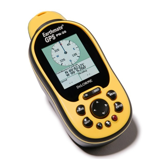
- Page 38 The Compass Page The Compass Page The Compass Page The Compass Page Viewing the Compass Page Viewing the Compass Page The Compass Page is a graphic representation of a traditional oating needle compass. Its appear The Compass Page is a graphic representation of a traditional oating needle compass. Its appear- - ance differs if you are navigating a route or tracking.
- Page 39 1. 1. From From the the Compass Page, Compass Page, press press MENU. MENU. 2. 2. Use Use the the arrow arrow keypad keypad to to highlight highlight Change Info Fields Change Info Fields . . 3. 3. Press Press ENTER.
- Page 40 The Trip Info Page includes eight information fields that occupy the entire screen (three information fields display if the Earthmate GPS PN-20 is in large text mode). You can customize each field with fields display if the Earthmate GPS PN-20 is in large text mode). You can customize each field with one of the many available information field options (see page 25 for a table of the information field...
- Page 41 4. 4. To To change which change which information fields information fields display in display in large te large text: a) a) Press Press MENU, MENU, highlight highlight the the Change Info Fields Change Info Fields option, and press ENTER. option, and press ENTER.
- Page 42 Note Note : Resetting Trip Values resets the trip odometer for the current Trip Info reading, while : Resetting Trip Values resets the trip odometer for the current Trip Info reading, while The Trip Info Page The Trip Info Page resetting Device Odometer resets the cumulative odometer for all trips on the device.
-
Page 43: The Fi The Find Page
The Find Page The Find Page Notes: Notes: • Press a button during a search • Press a button during a search Using the Find Page Using the Find Page to halt the search process. to halt the search process. Select Select Continue Search ... - Page 44 press ENTER to delete the waypoint from the Earthmate GPS PN-20. press ENTER to delete the waypoint from the Earthmate GPS PN-20. The Find Page The Find Page To center center the the map...
- Page 45 To center center the the map map on on the the location, use location, use the the arrow arrow keypad keypad to to highlight highlight the the View View button and button and press ENTER. press ENTER. ...
- Page 46 The Find Page The Find Page To create create a a route route from from your current your current location to location to the search the search result, use result, use the the arrow arrow keypad to keypad to highlight the...
- Page 47 To Find a Coordinate To Find a Coordinate 1. 1. Press Press the the Find Find button. The Find Page displays. button. The Find Page displays. 2. 2. Use Use the the arrow arrow keypad keypad to to highlight the highlight the Show Show field, press ENTER, and then select field, press ENTER, and then select Coordi-...
- Page 48 The Find Page The Find Page Narrow Narrow this this search search by by completing one completing one or or more more of of the the remaining remaining fields. Highlight fields. Highlight the the field field and press ENTER to use the keyboard to enter the search information.
- Page 49 press ENTER. Use the arrow keypad to update the label, coordinates, elevation, and com- press ENTER. Use the arrow keypad to update the label, coordinates, elevation, and com- ments. Press ENTER after you edit each group of information. ments.
- Page 50 To Find Recent Searc Find Recent Searc h Results h Results The Find Page The Find Page You can view a history of your past ten search results. You can view a history of your past ten search results. 1.
- Page 51 Using the Mark Button You can use the Mark button (the button with a push pin) on the Earthmate GPS PN-20 to mark a You can use the Mark button (the button with a push pin) on the Earthmate GPS PN-20 to mark a waypoint at your current GPS location or, if panning, at the cursor position.
- Page 52 Comment Details to display the entire comment. • • To save the waypoint to the Earthmate GPS PN-20, use the arrow keypad to highlight the To save the waypoint to the Earthmate GPS PN-20, use the arrow keypad to highlight the Save Save ...
- Page 53 the waypoint, based on the current GPS heading. The Distance information field displays the the waypoint, based on the current GPS heading. The Distance information field displays the distance from your current location to the selected waypoint. distance from your current location to the selected waypoint. 2.
- Page 54 Note Note : If the comment length exceeds the comment area, press MENU and highlight View The Waypoints Page The Waypoints Page : If the comment length exceeds the comment area, press MENU and highlight View Comment Details to display the entire comment. Comment Details to display the entire comment.
- Page 55 Yes Yes button and press ENTER to delete the waypoints button and press ENTER to delete the waypoints with that symbol from the Earthmate GPS PN-20. with that symbol from the Earthmate GPS PN-20. To Delete All Waypoints To Delete All Waypoints 1.
- Page 56 Using the Route Page There are many ways to create routes on the There are many ways to create routes on the Earthmate GPS P Earthmate GPS PN-20. N-20. You can create a route: You can create a route: • • From your From your current GPS location to current GPS location to a waypoint.
- Page 57 arrow keypad to highlight arrow keypad to highlight Current Position Current Position and press ENTER. Use the arrow keypad to and press ENTER. Use the arrow keypad to highlight highlight Remove Remove and then press ENTER. and then press ENTER. highlight the Calculation Method Calculation Method drop- 5.
- Page 58 To Edit a Route To Edit a Route The Routes Page The Routes Page From the Routes Page, use the arrow keypad to highlight the route that you want to edit and press From the Routes Page, use the arrow keypad to highlight the route that you want to edit and press ENTER.
- Page 59 To Reverse a Route To Reverse a Route 1. 1. From the From the Routes Page, use Routes Page, use the arrow the arrow keypad to keypad to highlight the route highlight the route that you that you want to want to reverse.
- Page 60 For Direct, choose Automatic to continuously recalculate from the current GPS location to For Direct, choose Automatic to continuously recalculate from the current GPS location to The Routes Page The Routes Page the next stop in the route. Choose Prompt to alert you when you are off track; you can then the next stop in the route.
- Page 61 Using the Tracks Page Using the Tracks Page Your Earthmate GPS PN-20 is set by default to record GPS tracks. That means the device creates Your Earthmate GPS PN-20 is set by default to record GPS tracks. That means the device creates Note: ...
- Page 62 Clear Clear button and press ENTER. button and press ENTER. The active track is cleared from the Earthmate GPS PN-20. The active track is cleared from the Earthmate GPS PN-20. Tip: Tip: Select Select...
- Page 63 To Customize the Logging Preferences To Customize the Logging Preferences Use the following steps to designate if you want the device to log GPS points based on time or dis- Use the following steps to designate if you want the device to log GPS points based on time or dis- tance intervals.
- Page 64 3. 3. To To enable the Reset enable the Reset Info screen Info screen if the if the check box check box is cleared, highlight is cleared, highlight the the Prompt to Reset Prompt to Reset The Tracks Page The Tracks Page Trip Info Trip Info check box and press ENTER.
- Page 65 The Sun/Moon Page The Sun/Moon Page Using the Sun/Moon Page Using the Sun/Moon Page Use the Sun/Moon Page to view the sunrise/sunset and moonrise/moonset information and the Use the Sun/Moon Page to view the sunrise/sunset and moonrise/moonset information and the moon phase information for your current GPS location.
- Page 66 To View the Sun and Moon Rise/Set Information To View the Sun and Moon Rise/Set Information The Sun/Moon Page The Sun/Moon Page The Sun/Moon rise and set information is found underneath the Sun/Moon graphics. The informa- The Sun/Moon rise and set information is found underneath the Sun/Moon graphics. The informa- tion displays the time that both the sun and moon will rise and set based on the current time and tion displays the time that both the sun and moon will rise and set based on the current time and date settings.
- Page 67 The Tide Page The Tide Page Using the Tide Page Using the Tide Page Use the Tide Page to view high and low tide information based on a specific time, date, and tide Use the Tide Page to view high and low tide information based on a specific time, date, and tide station.
-
Page 68: The Hunt/Fish Page
The Hunt/Fish Page The Hunt/Fish Page The Hunt/Fish Page The Hunt/Fish Page Using the Hunt/Fish Page Using the Hunt/Fish Page Use the Hunt/Fish page to view a prediction of the type of day it will be for hunting or fishing, the Use the Hunt/Fish page to view a prediction of the type of day it will be for hunting or fishing, the best times to hunt or fish, and good times to hunt or fish for your current GPS location. - Page 69 Tip: When viewing the Device When viewing the Device Use the Device Setup Page options to modify the default settings on the Earthmate GPS PN-20, Use the Device Setup Page options to modify the default settings on the Earthmate GPS PN-20,...
- Page 70 • • Select Select DeLorme DeLorme if you are using the device with compatible DeLorme mapping software. if you are using the device with compatible DeLorme mapping software. 3. 3. Press QUIT Press QUIT to to return return to to the Device the Device Setup Page.
- Page 71 To Modify the Sound Settings To Modify the Sound Settings To modify the device’s button press sound, message sound, power sound, turn alert sound, and/ To modify the device’s button press sound, message sound, power sound, turn alert sound, and/ or the volume of all sounds, from the Device Setup Page, highlight the or the volume of all sounds, from the Device Setup Page, highlight the Sound Sound option and press...
- Page 72 To Modify the Page Order Se Modify the Page Order Se ttings ttings The Device Setup Page The Device Setup Page To change the page order, add a page to the page button sequence, or hide a page, from the Device To change the page order, add a page to the page button sequence, or hide a page, from the Device Setup Page, highlight the Setup Page, highlight the Page Order...
- Page 73 To Modify the Units Settings To Modify the Units Settings From the Device Setup Page, highlight the Units Units option and press ENTER. Press QUIT at any time From the Device Setup Page, highlight the option and press ENTER. Press QUIT at any time to return to the Device Setup Page.
-
Page 74: The The Device Device Setup Setup Page
Device Setup screen restores all of the settings on the settings on the Earthmate GPS PN-20 to their “out-of-the-box” status and also deletes all tracks, routes, waypoints, etc. Earthmate GPS PN-20 to their “out-of-the-box” status and also deletes all tracks, routes, waypoints, etc. - Page 75 Appendix Appendix A: Page Function Table A: Page Function Table This table provides an overview of what you can view/do on each page, as well as each page’s This table provides an overview of what you can view/do on each page, as well as each page’s menu functions: menu functions: W W i i t t h h t t h h i i s s P P a a g g e e .
- Page 76 Appendix A Appendix A W W i i t t h h t t h h i i s s P P a a g g e e ..Y Y o o u u C C a a n n ..A A n n d d U U s s e e t t h h e e P P a a g g e e ’...
- Page 77 W W i i t t h h t t h h i i s s P P a a g g e e ..Y Y o o u u C C a a n n ..A A n n d d U U s s e e t t h h e e P P a a g g e e ’...
- Page 78 Appendix A Appendix A W W i i t t h h t t h h i i s s P P a a g g e e ..Y Y o o u u C C a a n n ..A A n n d d U U s s e e t t h h e e P P a a g g e e ’...
- Page 79 W W i i t t h h t t h h i i s s P P a a g g e e ..Y Y o o u u C C a a n n ..A A n n d d U U s s e e t t h h e e P P a a g g e e ’...
- Page 80 Appendix B: Specifications Appendix B: Specifications Appendix B Appendix B Physical Specifications Physical Specifications Case: IPX-7 waterproof, impact resistant Case: IPX-7 waterproof, impact resistant Size: 5.25” x 2.43” x 1.5” Size: 5.25” x 2.43” x 1.5” Weight: 0.33 lb Weight: 0.33 lb T T echnical echnical Specifications...
- Page 81 Earthmate GPS PN-20 fails in normal fails in normal use, DeLorme will, at its sole option, either repair or replace the unit. DeLorme reserves the right to use, DeLorme will, at its sole option, either repair or replace the unit. DeLorme reserves the right to...
- Page 82 Such repairs or replacements will be made at no charge for labor or materials; however, the cus- tomer will be responsible for any shipping charges incurred to send the device to DeLorme. The re- tomer will be responsible for any shipping charges incurred to send the device to DeLorme. The re-...
- Page 83 If you have contacted DeLorme Support and have been instructed to send the device in for war- If you have contacted DeLorme Support and have been instructed to send the device in for war- ranty service, send the unit to:...
-
Page 84: Appendix C Waypoint Symbols
Appendix C Appendix C Appendix C Appendix C Waypoint Symbols Waypoint Symbols Birch Tree Birch Tree Danger Danger American Flag American Flag Bird Tracks Bird Tracks Deciduous Tree Deciduous Tree Anchor Anchor Bird Bird Deer Tracks Deer Tracks Animal Tracks Animal Tracks Boat Launch... - Page 85 Waypoint Symbols Waypoint Symbols Fish Fish Jeep Jeep Public Airport Public Airport Radio Tower Radio Tower Fishing Pole Fishing Pole Kayaking Kayaking Flower Garden Flower Garden Lighthouse Lighthouse Railroad Crossing Railroad Crossing Four-wheel ATV Four-wheel ATV Lodging Lodging Restroom Restroom Gas Station...
- Page 86 Waypoint Symbols Waypoint Symbols Appendix C Appendix C Push Pin Push Pin Tow Truck Tow Truck Small Dot Small Dot (available in red, dark (available in red, dark (available in red, dark (available in red, dark red, yellow, dark yellow, red, yellow, dark yellow, red, yellow, dark yellow, red, yellow, dark yellow,...
- Page 87 Back on Course— The direction of travel needed to return to the course. The direction of travel needed to return to the course. Base Map— Base Map— A low-detail map that comes pre-loaded on the Earthmate GPS PN-20. A low-detail map that comes pre-loaded on the Earthmate GPS PN-20. Battery Life—...
- Page 88 The relationship between the extent of features in the real world and the size at which they are portrayed on the map. On the Earthmate GPS PN-20, you can choose Bar, Zoom, or Ratio. are portrayed on the map. On the Earthmate GPS PN-20, you can choose Bar, Zoom, or Ratio.
- Page 89 Time to Next Turn— Time to Next Turn— The estimated time to the next turn in the route based on road classifications The estimated time to the next turn in the route based on road classifications and speed settings. and speed settings.
- Page 90 Compass Page ..Page ........... 37-38 37-38 Addresses ........45 Addresses ........45 Contactin Contacting DeLorm g DeLorme e ......81 ......81 Cities Cities................47-4 47-48 8 Contains ..........42 Contains ..........42 Coordinates ........46 Coordinates ........46 Creating Creating a route a route ........55...
- Page 91 Draw Layers .........48 Draw Layers .........48 Natural Natural feature features ..s ........44 44 -45 Points of Points of intere interest ..st .......4 ..4 3- 3- 44 Search Search results results .......49 .......49 Keyboard...
- Page 92 Restorin Restoring g ..............29 29 30 Showing........24 Showing........24 Orientation .........33 Orientation .........33 Index Index Editing........Editing........58 58 -5 -59 9 Page Page button button ..........3 ..........3 Reversing........58 Reversing........58 Page Page order order ..........71 ..........71 Simulating ........56...
- Page 93 Tide Page ...........66 Tide Page ...........66 WAAS ..WAAS ..............20-21, 20-21, 68 Time settings ........71 Time settings ........71 Warranty Warranty ................79 ..79 -8 -8 0 0 Tracking ..........
Need help?
Do you have a question about the Earthmate GPS PN-20 and is the answer not in the manual?
Questions and answers