Table of Contents
Advertisement
Quick Links
Advertisement
Table of Contents

Related Manuals for Leica Zeno GG04 plus


Summary of Contents for Leica Zeno GG04 plus
- Page 1 Leica Zeno GG04 plus User Manual Version 1.5 English...
- Page 2 All other trademarks are the property of their respective owners. Validity of this This manual applies to all models of the Leica GG04 plus GNSS instrument. manual Where there are differences between the various instruments they are clearly described.
- Page 3 Description myProducts Add all products that you and your company own and explore your world of Leica Geosystems: View detailed information on your products and update your products with the latest software and keep up- to-date with the latest documentation.
-
Page 4: Table Of Contents
3.2.2 Battery for GG04 plus Equipment Setup as a Real-Time Rover 3.3.1 Setup with Leica Zeno GIS Hardware and Software 3.3.2 Setup with Third-Party Mobile Devices Connection with Leica Zeno GIS Software Correction Service Spot Lite and Spot Prime (PPP) -
Page 5: Safety Directions
Safety Directions General Introduction Description The following directions enable the person responsible for the product, and the person who actually uses the equipment, to anticipate and avoid opera- tional hazards. The person responsible for the product must ensure that all users understand these directions and adhere to them. -
Page 6: De昀椀Nition Of Use
Use of products with recognisable damage or defects • • Use with accessories from other manufacturers without the prior explicit approval of Leica Geosystems Inadequate safeguards at the working site • Controlling of machines, moving objects or similar monitoring applications •... -
Page 7: Responsibilities
• To be familiar with local regulations relating to safety and accident pre- • vention To stop operating the system and inform Leica Geosystems immediately if • the product and the application become unsafe • To ensure that the national laws, regulations and conditions for the oper-... - Page 8 WARNING Inadequate securing of the working site This can lead to dangerous situations, for example in traf昀椀c, on building sites and at industrial installations. Precautions: ▶ Always ensure that the working site is adequately secured. ▶ Adhere to the regulations governing safety, accident prevention and road traf昀椀c.
- Page 9 Risk of injuries to users and equipment destruction due to lack of repair knowledge. Precautions: ▶ Only authorised Leica Geosystems Service Centres are entitled to repair these products. CAUTION Not properly secured accessories If the accessories used with the product are not properly secured and the product is subjected to mechanical shock, for example blows or falling, the product may be damaged or people can sustain injury.
-
Page 10: Batteries
CAUTION Keeping the device too close to the human body during operation Health risk Precautions: ▶ Use the device at least 10 mm apart from the human body. ▶ This device has been tested for typical operations near the human body, for example handheld mode, with the device kept at 10 mm from the user’s body. -
Page 11: Electromagnetic Compatibility (Emc)
Using the product after incorrect attempts were made to carry out repairs. Precautions: ▶ Do not open the product! ▶ Only authorised Leica Geosystems Service Centres are entitled to repair these products. Electromagnetic Compatibility (EMC) Description The term Electromagnetic Compatibility is taken to mean the capability of... - Page 12 Although the product meets the strict regulations and standards which are in force in this respect, Leica Geosystems cannot completely exclude the possib- ility that the function of the product may be disturbed in such an electromag- netic environment.
- Page 13 Precautions: ▶ Although the product meets the strict regulations and standards which are in force in this respect, Leica Geosystems AG cannot completely exclude the possibility that other equipment can be disturbed or that humans or animals can be affected.
-
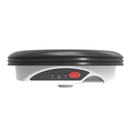
Page 14: Description Of The System
Firmware concept The instrument is delivered with the latest 昀椀rmware version installed. If a new 昀椀rmware version is released at a later point in time, use the Leica Zeno GIS software on Windows to upload this version by a Bluetooth connection. - Page 15 Component Description Bluetooth To wireless pair with Leica Zeno GIS or third-party hardware. Battery The battery compartment holds the GEB212 battery for power supply. LEDs Indication of power, Bluetooth and signal reception. LEMO-1 connector Serial by RS232 or USB communication.
-
Page 16: Data Collection
Leica Zeno GIS Software Description All Leica Zeno GIS hardware and software can utilise the GG04 plus with a survey pole. The compatible hardware includes the Zeno 5, Zeno 10, Zeno 15, Zeno Tab 1, Zeno Tab 2, CS25, CS25 plus, CS25 GNSS, CS25 LRBT and selected Android, iOS or Windows devices. -
Page 17: Accessories
Accessories Description Extra equipment such as cables and universal pole holders are listed in the setup sections. Any further description of accessories is not part of this manual. Refer to the LeicaZeno GIS Equipment List. Description of the System... -
Page 18: Operation
It is normal for the battery to become warm during charging. Using the • chargers recommended by Leica Geosystems, it is not possible to charge the battery once the temperature is too high For new batteries or batteries that have been stored for a long time •... -
Page 19: Equipment Setup As A Real-Time Rover
This chapter shows a possible pole setup with Leica Zeno GIS hardware and software. Connection between the GG04 plus instrument and the 昀椀eld controller is made through Bluetooth. All hardware is 昀椀xed on a Leica carbon pole in this example. The antenna is mounted directly using screw 昀椀tting. -
Page 20: Setup With Third-Party Mobile Devices
Zeno Connect to utilise the position in a third-party software. Connection between the GG04 plus instrument and the mobile device is made through Bluetooth. All hardware is 昀椀xed on a Leica carbon pole in this example. The antenna is mounted directly using screw 昀椀tting. -
Page 21: Connection With Leica Zeno Gis Software
☞ eral minutes. Principle of Zeno Connect is the con昀椀guration software for your Leica GG04 plus Smart Zeno Connect Antenna. With Zeno Connect the highly accurate position achievable with the GG04 plus antenna can be utilised by location aware applications running on iOS, Android or Windows. - Page 22 Different versions There are three different versions of Zeno Connect available. One for iOS, one available for for Android and one for Windows. Zeno Connect Zeno Connect for iOS and Android is available for download from the respect- ive App Stores. A valid internet connection is necessary. Unlike the Windows Zeno Connect version, a license for Zeno Connect on Android smartphones and tablets or iPhone and iPad is included with the GG04 plus antenna pur- chase.
- Page 23 Leica Zeno Mobile is an Android app available on selected Android phones and Zeno Mobile tablets and the Leica Zeno 20 handheld data collector. The aim of Zeno Mobile is to keep things simple while still offering a host of professional data capture functions to increase productivity in the 昀椀eld.
-
Page 24: Correction Service Spot Lite And Spot Prime (Ppp)
When paired with the Leica GG04 plus Smart Antenna, Zeno Mobile captures points, line and polygon data down to 1‑2 centimetres accuracy in even the most demanding GNSS environments. Different versions available for Zeno Mobile There are two different versions of Zeno Mobile available for download from... - Page 25 Spot corrections include GLONASS, Galileo and BeiDou information. ☞ To optimize the GG04 plus spot performance, think about adding GNSS options to support those satellite systems. Service activation After ordering the subscription service, activate the respective Spot option once within 30 days of the order date. To complete the activation process, switch on the antenna and leave it running in very good GNSS conditions for up to three hours.
-
Page 26: Care And Transport
Shipping When transporting the product by rail, air or sea, always use the complete original Leica Geosystems packaging, container and cardboard box, or its equi- valent, to protect against shock and vibration. Shipping, transport of When transporting or shipping batteries, the person responsible for the... - Page 27 Cables and plugs Keep plugs clean and dry. Blow away any dirt lodged in the plugs of the connecting cables. Care and Transport...
-
Page 28: Technical Data
Technical Data Tracking Characteristics GG04 plus Satellite reception Multi-frequency Instrument channels ☞ Depending on the satellite systems and signals con昀椀gured, a max- imum number of 555 channels is allocated. Supported signals System Signal L1 C/A, L2P, L2C, L5 GLONASS L1, L2 Galileo E1, E5a, E5b, AltBOC, E6 BeiDou... -
Page 29: Technical Data
Measurement precision, accuracy and reliability depend upon various factors including number of available satellites, geometry proximity to base station, multipath effects or ionospheric conditions. Post-processed Type Accuracy accuracy Baseline mode L1 Phase 10 mm + 1 ppm RMS Measurement precision, accuracy and reliability depend upon various factors including number of available satellites, geometry proximity to base station, multipath effects or ionospheric conditions. -
Page 30: Conformity To National Regulations
115200/N/8/1/N RTS/CTS Conformity to National Regulations Hereby, Leica Geosystems AG declares that the radio equipment type GG04 plus is in compliance with Directive 2014/53/EU and other applicable European Directives. The full text of the EU declaration of conformity is avail- able at the following Internet address: http://www.leica-geosys-... -
Page 31: Fcc Statement, Applicable In U
5.4.1 FCC Statement, Applicable in U.S. Labelling GG04 plus Model: GG04 plus Art.No.: 867128 Equip.No.: 12345678 S.No.: 1234567 Leica Geosystems AG, CH 9435 Heerbrugg Manufactured: 20YY, Made in Switzerland Power: 7.4 V nominal / 0.5 A max. IP66 IP68 202-SMF096... - Page 32 Consult the dealer or an experienced radio/TV technician for help. • Changes or modi昀椀cations not expressly approved by Leica Geosystems for compliance could void the user's authority to operate the equipment. Canada CAN ICES-003 B/NMB-003 B...
-
Page 33: Ised Statements (En/Fr), Applicable In Canada
Leica Geosystems has developed Guidelines on “How to carry Leica ☞ products” and “How to ship Leica products” with Lithium batteries. Before any transportation of a Leica product, we ask you to consult these guidelines on our web page (IATA Lithium... -
Page 34: Software Licence Agreement/Warranty
Property Rights, Limitation of Liability, Exclusion of other Assurances, Govern- ing Law and Place of Jurisdiction. Please make sure, that at any time you fully comply with the terms and conditions of the Leica Geosystems Software Licence Agreement. Such agreement is provided together with all products and can also be referred to and downloaded at the Leica Geosystems home page at Hexagon −... -
Page 35: Appendix A Firmware Upgrade
Connect the GG04 plus to your computer by Bluetooth. Use Leica Zeno Firmware Upload Tool to upgrade the latest 昀椀rm- ware version. Refer to the corresponding software documentation on how to connect the instrument to your device and how to use Leica Zeno GIS Tools. -
Page 36: Appendix B Pin Assignments And Sockets
Appendix B Pin Assignments and Sockets Description Some applications require knowledge of the pin assignments for the instru- ment ports. In this chapter, the pin assignments and sockets for the instrument ports are explained. Port at the instru- ment underside Lemo port (USB and serial) 012547_001... - Page 38 868033-1.5.0en Original text Published in Switzerland, © 2023 Leica Geosystems AG Leica Geosystems AG Heinrich-Wild-Strasse 9435 Heerbrugg Switzerland www.leica-geosystems.com...
Need help?
Do you have a question about the Zeno GG04 plus and is the answer not in the manual?
Questions and answers