Table of Contents
Advertisement
Quick Links
Advertisement
Table of Contents

Related Manuals for Leica RTC360


Summary of Contents for Leica RTC360
- Page 1 Leica RTC360/RTC360 LT User Manual Version 3.1 English...
- Page 2 United States and other countries All other trademarks are the property of their respective owners. Leica Geosystems On the last page of this manual, you can find the address of Leica Geosystems address book headquarters. For a list of regional contacts, please visit http://leica-geosystems.com/contact-us/sales_support.
- Page 3 It covers the benefits of course using it, how it works and how to use it. https://learning.leica-geosystems.com/course/ view.php?id=142 Refer to the following resources for all RTC360/RTC360 LT documenta- tion/software: The supplied USB documentation card • https://myworld.leica-geosystems.com •...
-
Page 4: Table Of Contents
Table of Contents Safety Directions General Introduction Definition of Use Limits of Use Responsibilities Hazards of Use Laser Classification 1.6.1 General 1.6.2 Scanning Laser Electromagnetic Compatibility (EMC) FCC Statement, Applicable in U.S. ISED Statements (EN/FR), Applicable in Canada Description of the System Packing / Unpacking the Instrument Container Contents Backpack Contents... - Page 5 General Technical Data of the Product System Performance Laser System Performance Electrical Data 6.4.1 Pin Assignment of Lemo Ports Environmental Specifications 6.5.1 RTC360/RTC360 LT 6.5.2 GEB361 Battery and GEV282 AC/DC Power Supply Dimensions Weight Accessories Conformity to National Regulations 6.9.1 RTC360/RTC360 LT 6.9.2...
-
Page 6: Safety Directions
Safety Directions General Introduction Description The following directions enable the person responsible for the product, and the person who actually uses the equipment, to anticipate and avoid opera- tional hazards. The person responsible for the product must ensure that all users understand these directions and adhere to them. -
Page 7: Limits Of Use
Suitable for use in dry environments only and not under adverse conditions. Responsibilities Manufacturer of the Leica Geosystems AG, CH-9435 Heerbrugg, hereinafter referred to as product Leica Geosystems, is responsible for supplying the product, including the User Manual and original accessories, in a safe condition. Safety Directions... -
Page 8: Hazards Of Use
To be familiar with local regulations relating to safety and accident pre- • vention To inform Leica Geosystems immediately if the product and the applica- • tion become unsafe To ensure that the national laws, regulations and conditions for the oper- •... - Page 9 If the instrument moves unexpectedly during operation, stop the instrument ☞ via user interface (display, key) or alternatively remove the battery or main power source to prevent further movements. CAUTION Not properly secured accessories If the accessories used with the product are not properly secured and the product is subjected to mechanical shock, for example blows or falling, the product may be damaged or people can sustain injury.
- Page 10 Always prevent access to the product by unauthorised personnel. Product-specific treatment and waste management information can be received from your Leica Geosystems distributor. Applies only for California. The product contains CR Lithium Cell(s) ☞ with perchlorate material inside – special handling may apply.
- Page 11 Risk of injuries to users and equipment destruction due to lack of repair knowledge. Precautions: ▶ Only authorised Leica Geosystems Service Centres are entitled to repair these products. For the AC/DC power supply and the battery charger: WARNING Unauthorised opening of the product...
-
Page 12: Laser Classification
These products are safe under reasonably foreseeable conditions of operation and are not harmful to the eyes provided that the products are used and maintained in accordance with this User Manual. Description RTC360 RTC360 LT Wavelength 1550 nm 1550 nm Maximum pulse energy 1.5 µJ... -
Page 13: Electromagnetic Compatibility (Emc)
Class 1 Laser Product according to IEC Laser beam 60825-1 Vertical laser scanning area (2014-05) Horizontal laser scanning area RTC360 LT 90° Model: RTC360 LT Art. No.: 877118 S.No.: 3005001 0° Equip. No.: 1234567 360° WLAN PW: 12345678 Power : 24V 75W max. - Page 14 Although the product meets the strict regulations and standards which are in force in this respect, Leica Geosystems cannot completely exclude the possib- ility that function of the product may be disturbed in such an electromagnetic environment.
-
Page 15: Fcc Statement, Applicable In U
Precautions: ▶ Although the product meets the strict regulations and standards which are in force in this respect, Leica Geosystems cannot completely exclude the possibility that other equipment can be disturbed or that humans or animals can be affected. ▶... - Page 16 / 5.6 Ah Made in China 15 A / 62 Wh Leica Geosystems AG, CH-9435 Heerbrugg This device complies with part 15 of the FCC Rules. Operation is subject to the following two conditions: (1) This device may not cause harmful interference, and (2) this device must accept any interference received, including interference that may cause undesired operation.
-
Page 17: Ised Statements (En/Fr), Applicable In Canada
Labelling GEV282 16773_001 ISED Statements (EN/FR), Applicable in Canada WARNING This Class (B) digital apparatus complies with Canadian ICES-003. Cet appareil numérique de la classe (B) est conforme à la norme NMB-003 du Canada. Canada Compliance Statement This device contains licence-exempt transmitter(s)/receiver(s) that comply with Innovation, Science and Economic Development Canada’s licence- exempt RSS(s). -
Page 18: Description Of The System
Use caution due to the weight of the instrument (6 kg). ☞ Container Contents Container contents RTC360/RTC360 LT laser scanner GEB361 Lithium-Ion batteries GKL341 Multicharger Professional 5000 RTC360 USB flash drive 256 GB RTC360 rain cover RTC360/RTC360 LT Quick Guide RTC360 System USB card Tribrach* Tribrach adapter* RTC360 transport con-... -
Page 19: Backpack Contents
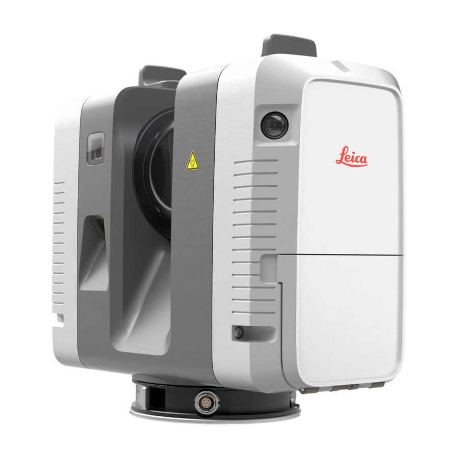
Lightweight tripod 0016153_001 Instrument Components Instrument components Antennas Rotating mirror/laser aperture HDR cameras Cameras for visual inertial sys- tem (RTC360 only) Quick release LED indicator Battery compartment Touch screen On/Off button Ventilation slots USB slot Socket for power supply, 5 pin... -
Page 20: System Components
The instrument comes with two Leica MS256 USB sticks (exFAT formatted) which fit into the USB slot of the instrument. ☞ Only use the Leica MS256 USB stick. Other devices are not compatible and may damage the instrument. ☞ Unplugging connecting cables or removing the USB stick during the measure- ment can cause loss of data. - Page 21 Data transfer The LeicaMS256 USB stick is used to transfer data from the instrument to external computers. All data recorded by the instrument and all meta data created by the field app on the remote tablet is stored on the USB stick. Type Description Data...
-
Page 22: User Interface
User Interface Power Button Power button Power button 0016145_001 5 001 Power button when the instrument is THEN Press and hold the off. The instrument switches button 1 sec. on and the Power button starts blinking yellow. Press and hold the on and ready. - Page 23 Operation mode Power LED indicator Instrument status button The instrument is off. The instrument is booting The instrument is ready. The instrument is recording. The instrument is being moved and the visual inertial system is recording (RTC360 only). User Interface...
-
Page 24: Screen
Power LED indicator Instrument status button The instrument is shutting down. An unrecoverable system error occurred. Follow the instructions in the display. If necessary, shut down the instrument and reboot again. If status does not change, contact the instrument sup- port. -
Page 25: Operation
Operation Instrument Setup 4.1.1 General Information Use the tripod The instrument should always be set up on its tripod. Using the tripod spe- cified for the scanning system guarantees maximum stability during scanning operations. Always set up the instrument on its tripod. Do not set up the instru- ☞... -
Page 26: Heavy Duty Tripod Setup
4.1.3 Heavy Duty Tripod Setup Instrument setup step-by-step 16155_002 Extend the tripod legs to allow for a comfortable working posture. Ensure that the tripod plate is roughly horizontal. Place the tribrach on the tripod and secure it with the central fixing screw. -
Page 27: Power Supply
For Li-Ion batteries, a single discharging and charging cycle is sufficient. • We recommend carrying out the process when the battery capacity indic- ated on the charger or on a Leica Geosystems product deviates signific- antly from the actual battery capacity available. Operation/discharging The batteries can be operated from −20 °C to +55 °C/−4 °F to +131 °F. -
Page 28: Operation - Getting Started
Insert and remove the exchangeable batter- 16149_002 Open the battery compartment. Remove the left battery from the battery compartment by pushing the upper red button to the right. Remove the right battery from the battery compartment by pushing the lower red button to the left. Insert the new batteries into the battery compartment. - Page 29 Start the instrument and wait until the user interface is visible. held device On the handheld device select Settings and tap WLAN. step-by-step Select the network RTC360-298xxxx/RTC360LT-3005xxx in the WLAN settings to be connected. ☞ The number 298xxxx/3005xxx is the serial number of the instrument.
-
Page 30: Imaging
☞ Imaging Description The instrument has two different types of image sensors: Three calibrated cameras for HDR, 360° spherical image acquisition. • Five calibrated cameras for the visual inertial system VIS (RTC360 only). • Imaging 16151_002 16151 002 0016150_001 3 cameras for HDR imaging... -
Page 31: Onboard Controls
The Start screen is displayed after the system boot process. Once it is visible screen the instrument is ready for scanning. 16630_001 19620_001 RTC360 RTC360 LT Element Description Status field WLAN enabled Status of exchangeable battery 100% - 75% of capacity left... - Page 32 Element Description Battery not inserted When facing the battery compartment: Left battery icon indicates the status • of the battery on the left side of the battery compartment. Right battery icon indicates the status • of the battery on the right side of the battery compartment.
- Page 33 High scan resolution: 3 mm@10 m, maximum range 65 m HDR image acquisition enabled HDR image acquisition disabled Double Scan enabled Double Scan disabled Visual inertial system VIS enabled (RTC360 only) Visual inertial system VIS disabled (RTC360 only) Setup field Number of setups in current job Click the Setup field to open the setups list with a thumbnail for each setup.
-
Page 34: Settings
Tap the checkbox to enable HDR image acquisition. Tap the checkbox to enable Double Scan. Tap the checkbox to enable the visual inertial system VIS (RTC360 only). Instrument Tap the checkbox to enable settings WLAN. The storage space available on the USB stick is displayed. - Page 35 Element Description ☞ Formatting is irreversible. Make sure to back up the data from USB stick before formatting to avoid loss of data. When quick Format is per- formed the content of the USB stick is deleted and default directories "RTC360Store" and "Languages"...
- Page 36 If an incorrect PIN code has consecutively been entered five times, the instrument is locked. An unlocking key must be loaded to unlock the instrument. In order to get the unlocking key, con- tact the Leica support. Language Tap the arrow to select one of settings the available languages from the list.
- Page 37 When the transfer is complete a message is dis- played. Check & Tap Start to start the Check & Adjust Adjust procedure. ☞ Before performing the Check & Adjust, read the separate RTC360/RTC360 LT Check & Adjust User Manual. Operation...
-
Page 38: Troubleshooting
Element Description ☞ Refer to section 5.2 Check & Adjust for more information about the Check & Adjust. ☞ Do not remove the USB stick during Check & Adjust procedure. System Tap View to get displayed information information like: Instrument Type •... -
Page 39: Field Of View (Fov)
Troubleshooting - If you experience problems with your instrument, e-mail the scanner's log files support contacts to your local support: For America: • us-support@hds.leica-geosystems.com For South America: • suporte@leica-geosystems.com.br For Europe, Middle East and Africa: • euro-support@hds.leica-geosystems.com For Asia: •... -
Page 40: Working With The Usb Data Storage Device
USB stick. 16468_002 Open the USB compartment at the bottom of the instrument. To insert the MS256 USB stick, hold the stick with the Leica logo facing to the right. Slide it into the USB slot until it clicks into position. -
Page 41: Care And Transport
• instrument. Refer to the separate RTC360/RTC360 LT Check & Adjust User Manual: for more information about the Check & Adjust, • how to select a suitable location to perform a Check & Adjust. -
Page 42: Cleaning And Drying
Li-Ion battery Refer to 6.5.2 GEB361 Battery and GEV282 AC/DC Power Supply • information about storage temperature range. Remove batteries from the product and the charger before storing. • After storage recharge batteries before using. • Protect batteries from damp and wetness. Wet or damp batteries must be •... -
Page 43: Maintenance
Do not use air from the pneumatic power system as this is always slightly • oily! Maintenance An inspection of the product must be done in a Leica Geosystems authorized ☞ service workshop. Leica Geosystems recommends an inspection of the product every 12 months. -
Page 44: Technical Data
White balancing Automatic Automatic, 5 brackets Minimum range 0.5 m Additional internal The RTC360/RTC360 LT is a multi-sensor system equipped with various integ- sensors rated sensors to allow for automated (RTC360 only) or semi-automated online registration in the field. Sensor Description... -
Page 45: Laser System Performance
Laser scanning The scanning system is a high speed time-of-flight unit, enhanced by Wave- system data form Digitising (WFD) technology with a maximum scan rate of: RTC360: 2.000.000 points/second • RTC360 LT: 1.000.000 points/second • Laser unit: Scanning laser Value Classification Laser Class 1 (in accordance with IEC 60825‑1... -
Page 46: Electrical Data
Medium High density Scan duration for 3 settings: Point density mode Resolution Estimated scan [mm @ 10 m] duration [MM:SS] for a full dome scan RTC360 RTC360 LT 00:25 00:50 Medium 00:50 01:40 High density 01:40 03:25 Image capturing time:... -
Page 47: Pin Assignment Of Lemo Ports
Power consumption: Instrument 30 W typical; 75 W max. GEB361 exchangeable Supply Value battery Type Li-Ion Voltage 11.1 V Capacity 5.6 Ah Battery operating and Exchangeable Value charging times battery Operating time up to 60 setups per battery set, typical continuous use: at room temperature, •... -
Page 48: Environmental Specifications
Name Function PWR_IN Power-In, 24 V Do not connect Ground Ground PWR_IN Power-In, 24 V Environmental Specifications 6.5.1 RTC360/RTC360 LT Environmental spe- Temperature range: cifications RTC360/ Type Operating temperature Storage temperature RTC360 LT [°C] [°C] RTC360/RTC360 LT −5 to +40 −40 to +70... -
Page 49: Geb361 Battery And Gev282 Ac/Dc Power Supply
GAD120 tribrach 104.5 × 81.2 4.1 × 3.2 adapter GAD121 adapter 104.5 × 35 5.7 × 1.4 plate for flexible mounting GAD122 adapter to 104.5 × 40 4.1 × 1.6 mount a RTC360 on top of a Leica tripod Technical Data... - Page 50 RTC360/RTC360 LT laser scanner: 16234_002 GAD120 tribrach adapter: Ø 104.5 16236_003 GAD121 adapter plate for flexible mounting: Ø 104.5 16237_002 GAD122 adapter to mount a RTC360 on top of a Leica tripod: Ø 104.5 16830_002 Technical Data...
-
Page 51: Weight
RTC360 tribrach adapter GAD120 • RTC360 adapter plate for flexible mounting GAD121 • Adapter to mount a RTC360 on top of a Leica tripod GAD122 • RTC360 backpack GVP730 • Range of Customer Care Products (CCP) that include support and hard- •... -
Page 52: Dangerous Goods Regulations
Leica Geosystems has developed Guidelines on “How to carry Leica ☞ products” and “How to ship Leica products” with Lithium batteries. Before any transportation of a Leica product, we ask you to consult these guidelines on our web page (http://www.leica-geosystems.com/dgr) to ensure that you are in accordance with the IATA Dangerous Goods Regulations and that the Leica products can be transported correctly. -
Page 53: Software Licence Agreement/Warranty
International Limited This product is subject to the terms and conditions set out in the International Warranty Limited Warranty which you can download from the Leica Geosystems home page at www.leica-geosystems.com/internationalwarranty or collect from your Leica Geosystems distributor. Software Licence... - Page 54 870891-3.1.0en Original text Printed in Switzerland © 2020 Leica Geosystems AG, Heerbrugg, Switzerland Leica Geosystems AG Heinrich-Wild-Strasse CH-9435 Heerbrugg Switzerland Phone +41 71 727 31 31 www.leica-geosystems.com...
Need help?
Do you have a question about the RTC360 and is the answer not in the manual?
Questions and answers
I am moving some scanning equipment (RTC360) back from Mexico for another job. The scanner got stuck in customs and requires the FDA Accession Number. Can you please provide the affirmations of compliance for this product?