Table of Contents
Advertisement
]
This device's electronic chat system(ECS) is developed for the
navigational aid only and chart itself does not obtain any approvals; has
not been certified from the government authorities. If operator needs
safe navigation then must use an official chart that has been approved
by government agencies; also operator is fully responsible for using this
device.
Caution
Contents
1. GPS PLOTTER ........................................................................................................................................ 3
1. GPS Overview .................................................................................................................................. 4
2. FEATURES .............................................................................................................................................. 5
1. GPS Antenna & Receiver .................................................................................................................. 6
2. Main Unit Features & Functions ........................................................................................................ 7
3. Standard Components ......................................................................................................................10
3. Device & Display .....................................................................................................................................12
1. Main Unit .........................................................................................................................................13
2. Remote Controller Button .................................................................................................................15
3. Power ON/OFF ................................................................................................................................16
4. Menu Composition ...........................................................................................................................17
5. Plotter Display ..................................................................................................................................18
4. Operating Instruction ...............................................................................................................................23
1. Data .................................................................................................................................................24
1.1 Track Data ..............................................................................................................................24
1.2 Mark Data ...............................................................................................................................32
1.3 User Coast Line ......................................................................................................................40
1.4 Waypoint Data.........................................................................................................................46
1.5 Route Data ..............................................................................................................................53
1.6 Disc Format ............................................................................................................................55
1.7 The Seabed Symbols ..............................................................................................................56
1.8 Software Update .....................................................................................................................57
2. Set Up .............................................................................................................................................58
2.1 Navigation Set Up ...................................................................................................................58
2.2. Alarm functions ......................................................................................................................69
2.3 How to set up Vessel ...............................................................................................................75
2.4 Cursor Setup ...........................................................................................................................79
2.5 Ship Tracking ..........................................................................................................................82
2.6 Simulation ...............................................................................................................................85
2.7 Miscellaneous Set ...................................................................................................................86
3. System.............................................................................................................................................91
3.1 Satellite Information ................................................................................................................91
3.2 Print-Out (USB - TBA) .............................................................................................................94
3.3 Keyboard Test .........................................................................................................................96
3.4 System Set .............................................................................................................................97
3.5 System Information ...............................................................................................................106
5. System Maintenance & Diagnosis .........................................................................................................107
1
2
Advertisement
Table of Contents

Related Manuals for Samyung ENC SGP-330


Summary of Contents for Samyung ENC SGP-330
-
Page 1: Table Of Contents
Contents 1. GPS PLOTTER ............................3 1. GPS Overview ..........................4 2. FEATURES .............................. 5 1. GPS Antenna & Receiver ........................6 2. Main Unit Features & Functions ......................7 3. Standard Components ........................10 3. Device & Display .............................12 1. Main Unit ............................13 2. -
Page 2: Gps Plotter
1. GPS Overview Global Positioning System IS based on the radio navigational system and satellites which provide an unlimited number of users with accurate three dimensional positions, velocity and time in straight 24 hours, worldwide coverage, under any weather condition. GPS has two types of Positioning such as 3D and 2D. -
Page 3: Features
1. GPS Antenna & Receiver GPS Antenna Type : All-weather Micro strip patch antenna FEATURES Power Supply : Receiver Module Size & Weight : 102 x 65mm (+150mm mounting bar) 0.2kg 2. FEATURES This chapter provides Features of NAVIS GPS Plotter. ... -
Page 4: Main Unit Features & Functions
2. Main Unit Features & Functions Navigation(1) Main specification RGB Signal Output: All monitors compatible with RGB input are available, such Drawing Method : Mercator s as CRT and Flat type Monitor Scale Range : 1/2,500 ~ 1/37,500,000(about 0.2nm ~ 5,000nm) ... -
Page 5: Standard Components
3. Standard Components SGP-330 Plotter Navigation(2) Item Specification Q’ty Remark Auxiliary Memory Unit: Coast Line, TRACK, Event, Waypoint, GPS Plotter SGP-330 User s Line to be saved. GPS Antenna SAN-60 Antenna Cable RG-58C/U 10/20m Disk save and SD card available. -
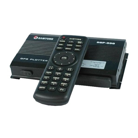
Page 6: Device & Display
Device & Display 3. Device & Display This Chapter explains Device and Display about SGP-330. 공 란 Main Unit Remote Controller Button Power ON/OFF Plotter Display... - Page 7 Rear Panel 1. Main Unit Front Panel GPS – ANT: RGB Output: DATA in/out: Power Switch: All monitors supportive with RGB Interface with other Receiving Main switch for power- input, such as CRT, flat monitor, products which Active ANT signal On/Off.
-
Page 8: Power On/Off
2. Remote Controller Button Frequency High/Low selecting 3. Power ON/OFF Button when used Fish Finder. (TBA) Power Button Main Power ON/OFF Sensitivity Button Sea Bottom Range Button (later on) Change sensitivity (Later on) It is designed to keep ON/OFF main power through “Rocker Switch” placed in rear panel of the Main Unit and when the switch is “ON”... -
Page 9: Menu Composition
4. Menu Composition 5. Plotter Display GPS Plotter Display 1.Data 1. Track Date 2.Set 1. Navigation Set 2, Mark Data 2. ALARM SET 3. User’s Line 3. Own Ship Set 4. Waypoint Data 4. Cursor Set 5, Route Data 5. - Page 10 Definition Description Own Ship Latitude Own ship’s Latitude position Own Longitude Own ship’s current Longitude Own Ship Speed Current own ship’s speed, SOG(Speed of Ground) . Own Ship Course Present own ship’s course , COG(Course of Ground) . GPS Status If no GPS or DGPS signal, Displays "Not-Ready"...
- Page 11 Day/Night Mode in Plotter Display Press ) Open the menu such as Transparency, Day/Night mode...
-
Page 12: Operating Instruction
1. Data 1.1 Track Data 1.1.1 Track Set It is a function to set own ship s Track in navigation. Operating Instruction Total track to be saved is 20,000 points, When it comes to be full memory, delete point one by one 4. - Page 13 1.1.2 Track Clear Use this function to erase the TRACK line of the vessel. Track Memory Interval Set Up Time setup [1.Data] [1.Track Data] [1.Set] [3.Time] • Distance setup [1.Data] [1.Track Data] ...
- Page 14 1.1.3 Track CALC Use this function to calculate the Vessel’s TRACK 1.1.4. Track Save Use this function to save TRACK DATA to selected device while vessel navigates. All track CALC. Save Track in built-in ROM [1.Data] [1.Track Data] ...
- Page 15 Saving Track by Transmitting Data 1.1.5 Track Load - It is the function to save after transmitting to other product through external in/output terminal Use this function to load saved file from “1.1.4 Track Save” and Display on the plotter screen. ...
-
Page 16: Mark Data
1.1.6 Track Erase Use this function to erase the TRACK file from storage device at '1.1.4 Track Save'. 1.2 Mark Data Take care when using the erase menu. Files erased during this process cannot be recovered. 1.2.1 Mark Select Use this function to select which MARK type to show on the screen. There are 21 unique MARK types. ... - Page 17 1.2.2 MARK Append Use this function to append MARK at location of vessel or certain Latitude/Longitude. Mark Append at own ship’s position [1.Data] [2.Mark Data] [2.Append] [1.Own ship’s position] Mark append to a certain Longitude/Latitude ...
- Page 18 1.2.3 Mark Clear '1.2.2 Function to clear a mark Clear MARK in Lat/Long [1.Data] [2.Mark Data] [3.Clear] [4.Lat/Lon] After selecting Lat., press after selecting Lon., press [REF] Shortcut to clear the Mark On the plotter screen, place on the mark to clear by using direction key...
- Page 19 1.2.4 MARK SAVE '1.2.2 MARK is saved to saving device as a file. 1.2.5 MARK Load '1.2.4 Display a mark on the plotter screen after recalling a saved file from a storage device. SAVE in built-in ROM [1.Data] ...
- Page 20 1.2.6 MARK ERASE '1.2.4 Erasing a saved MARK file from a storage device. 1.3 User Coast Line Take care when using the erase menu, files erased during this process cannot be recovered. 1.3.1 Coast Line Mark This function is used to display a coastal line drawn by a user onto the plotter screen. In the ON setting, the coastal line drawing is displayed.
- Page 21 1.3.2 Coastal Line Drawing Displays a coastal line drawn by a user. Up to 999 of each line drawing, MARKs or characters can be registered. [REF] 1. Line color can be changed by pressing button. How to erase coastal line ...
- Page 22 1.3.3 Coastal Line Storage '1.3.2 Coastal data’ is saved into a storage device in a coastal drawing. 1.3.4 Coastal Line Load '1.3.3 Display a mark in a Plotter Screen after recalling a saved file from a storage device. Coastal line storage in built-in ROM (only 1 file can be saved) ...
-
Page 23: Waypoint Data
1.3.5 Coastal Line Erase 1.4 Waypoint Data '1.3.3 Delete a coastal line file from a storage device. 1.4.1 Waypoint Mark Take care when using the erase menu, files erased during this process cannot be recovered. Use this function to place a waypoint onto a Plotter screen. ON , the waypoint is placed on the screen. - Page 24 1.4.2 Waypoint Edit Use this function to register a point of an important or frequent navigation. Up to 999 waypoints can be registered into memory. How to erase waypoint data registered On the waypoint edit window Select the blank number, (Converted to Center) ...
- Page 25 1.4.3 Waypoint Storage Use this function is to save the Lat/Long of a waypoint, MARK or name registered onto an available storage device as A file. Waypoint Storage by sending Data - It is a function to save by sending to another device using external in/out terminal. ...
- Page 26 1.4.4 WAYPOINT RECALL This function displays a waypoint on the Plotter screen after recalling a saved file from a storage device. 1.4.5 WAYPOINT ERASE '1.4.3 Deleted a coastal line file from a storage tool. Must be careful to command this erase due to no-recover the file. ...
- Page 27 1.5 Route Data 1.5.1 Route Edit Use this function to record a waypoint into a navigation route. Up to 20 waypoints can be recorded per route. The Lat/Lon of the waypoint can be recorded into [1.DATA] [4.WAYPOINT DATA] [2.EDIT] in advance to register to a route DATA.
-
Page 28: Disc Format
1.6 Disc Format New SD cards must be formatted prior to first use. No data will store until formatted. 1.7 The Seabed Symbols Use this function to place bottom feature symbols on the plotter chart. How to format a disk ... -
Page 29: Software Update
1.8 Software Update 2. Set Up Use this function to update the plotter software if it becomes necessary. 2.1 Navigation Set Up 2.1.1 How to set up waypoint navigation This function is used when the vessel navigates between two voluntary waypoints is registered on '1.4.2 WAYPOINT EDIT’... - Page 30 2.1.2 HOW TO SET UP A ROUTE NAVIGATION Set up a Navigation Route by using a menu This function is used when course navigating along a registered route on '1.5.1 ROUTE EDIT’. To cancel Waypoint Navigation Press on remote controller.
- Page 31 To cancel Route Navigation Press on remote controller. (☞ Refer to '2.1.4 NAVIGATION CLEAR)
- Page 32 Route Navigation Set by quick button Route Navigation Move a cursor to waypoint, (Register first route, waypoint no 9980) Move a cursor next waypoint, (Register second route, waypoint 9981: Able to register max. 20 pcs.) (Disappear cursor and cursor line.) ...
- Page 33 2.1.3 ANCHOR Use Anchorage Setup to establish the anchorage range so that the equipment can alert the operator when the vessel drifts out of the preset range. This function is using with '2.2.3 ANCHORAGE ALARM’. ANCHOR set [2.SET] ...
- Page 34 [REF] A red circle with alarm indicates Anchorage range when '2.2.3 ANCHOR ALARM' is ON. 2.1.4 EXIT WPT/RTE/ANCHOR This function cancel Waypoint/Route Navigation, Anchor(Position) Set. EXIT WPT/RTE/ANCHOR [2.SET] [1.NAVIGATION SET] [4.EXIT WPT/RTE/ANCHOR] For quick way to EXIT WPT/RTE/ANCHOR Press on remote controller.
-
Page 35: Alarm Functions
2.2. Alarm functions 2.2.2 Cross Track Error Alarm (XTE) 2.2.1 Arrival Alarm While using in the Navigation Mode, this function sounds an alarm to alert the operator of an off-course While using Waypoint Navigation and Route Navigation, this function is designed to sound an alarm once condition. - Page 36 2.2.3 Anchorage Alarm When using “2.1.3 Anchor (POS.) Set”, this function is to be alarmed when the vessel drifts out of the anchor set range due to tide and weather. Anchorage Alarm ON/OFF [2.SET] [2.ALARM SET] [3.ANCHOR ALARM] (Whenever press, [ON/OFF] repeatedly selected) ...
- Page 37 2.2.4 Underwater Cable Alarming This function is used to create an alarm zone around any underwater cables to aid in safe anchorage. 2.2.5 Water Depth Alarm This function is used to alert the operator when it senses any specific water depth within the preset alarm range.
-
Page 38: How To Set Up Vessel
2.3 How to set up Vessel RADIUS SET This function set is used to configure a variety of information on the vessel. - To indicate the radius in red circle, making the vessel as a starting point. [2.SET] ... - Page 39 HEADING SIZE SET [2.SET] [3.SHIP SET] [7.HEADING SIZE] (Whenever press, [SMALL/MID/LARGE] selected in order. HEADING COLOR 차적으로 선택됨 [2.SET] [3.SHIP SET] [8.HEADING COLOR] (Whenever press, [RED/GREEN/BLUE] selected in order.) HEADING SHAPE select ...
-
Page 40: Cursor Setup
2.4 Cursor Setup This enables the operator to set up the Cursor shown on the plotter display. CURSOR SHAPE [2.SET] [4.CURSOR SET] [3.CURSOR SHAPR] (Whenever press, [THIN/THICK] repeatedly selected.) CURSOR SIZE [2.SET] [4.CURSOR SET] ... -
Page 41: Ship Tracking
CURSOR LINE Has no this function) 2.5 Ship Tracking - When press cursor button, it is the function to ON/OFF of cursor line in blue color from own ship to cursor position. 2.5.1 Ship Tracking To track a vessel’s position and waypoint by inputting vessel ID to vessel. If you are willing to make this function is ON , it should be set '2.5.2 SHIP TRACK EDIT' first. - Page 42 Has no this function) 2.5.2 Ship Tracking Edit( [REF] Input “000000000”to delete a vessel ID and then press To input vessel ID, name, call interval to be used for ship tracking. Input a blank to delete a vessel name and then press ...
-
Page 43: Simulation
2.6 Simulation This enables the operators to display artificial data required for demonstration or testing purposes. 2.7 Miscellaneous Set User can set up many additional functions on SYSTEM and Plotter. Simulation Set 1. PLOTTER [2.SET] [6.SIMULATION] ... - Page 44 MAGNETIC VAR. SET - True North differs slightly from Magnetic North. This is 'Magnetic Bearing Deviation' and Magnetic North is meant for magnetic compass’s north. [2.SET] [7.ETC. SET] [2. MAGNETIC VAR.] Input value of magnetic north deviation, (Whenever press repeatedly, select “NM/KM/MM”) [REF] Except using Magnetic North if necessary, it should be always used True North .
- Page 45 WRECK DISPLAY [REF] How to display in another way [2.SET] [7.ETC. SET] [5. WRECK DISPLAY] on chart plotter [5.WRECK DISPLAY] and press Press (Whenever press, [ON/OFF] repeatedly selected) FISHING AREA - To display the info. Of fishing area by thick blue colored line. ...
-
Page 46: System
3. System 3.1 Satellite Information This function is to set up the relative information on GPS and DGPS for navigation. It is basically similar to DGPS (Differential GPS) but it also provides the more preciseness of position Date/Time Set information to decrease the position differentiation, through receiving the position correction signal from a - User can set up the information on the date and time. -
Page 47: Print-Out (Usb - Tba)
DGPS Mode 3.2 Print-Out (USB - TBA) [3.SYSTEM] [1.SATELLITE INFO] [6.DGPS MODE SET] To printout a current plotter screen by using printer. (Whenever press, Auto/Manual/WASS selected. ※ In case of select Manual Mode Input frequency ... -
Page 48: Keyboard Test
3.3 Keyboard Test Users can make a self-test to see if the remote works okay. How to test keyboard [3.SYSTEM] [3.KEYBOARD TEST] Check button’s reversal by pressing each button ... -
Page 49: System Set
Input PORT Set - Data input port of SYSTEM can be set up 3.4 System Set [3.SYSTEM] [4.SYSTEM SET] [1.INPUT PORT SET] Users can set up Input/Output ports used for system, AIS, memory, chart, language in use etc. (Whenever press, [Internal/External] selected repeatedly) [REF] ... - Page 50 Output PORT Set - Selection Range Available As a function to set up the data output of SYSTEM, it can be compatibly set up with other equipment. [3.SYSTEM] [4.SYSTEM SET] [2.OUTPUT PORT SET] Select Speed (bps) ...
- Page 51 AIS SET (Display Set) [3.SYSTEM] [4.SYSTEM SET] [3.AIS SET] [2.Display Set] AIS Target Color Set Press on target wishing to display (Check .) - Set a color by MID (Marine Identification No or Country Code) ...
- Page 52 Basic Information on AIS-mounted ships displayed on Screen Ship Name: Named for ship MMSI: ID Number assigned for ship to be identified SOG: Current speed of ship under voyage COG: Current course of ship under voyage ...
-
Page 53: System Information
MEMORY CLEAR - Delete all memory data and then make the equipment-initialized status. 3.5 System Information Users can display the system information such as LCD, Plotter Model, Program, Chart, PIC Version. [3.SYSTEM] [4.SYSTEM SET] [4.MEMORY CLEAR] ... -
Page 54: System Maintenance & Diagnosis
1. System Maintenance and Repair Routine maintenance and troubleshooting for the equipment ensures its normal performance. Maintenance and troubleshooting means periodical checking and cleaning the system. Item Contents Connector & Terminal Check whether Connector and terminal at the rear of the unit is properly System Maintenance &... - Page 55 1. Check LCD contact point. (RGB-OUT connector) line appears. 2. Clean contact point for LCD connector. (RGB-OUT connector) Screen color is sometimes This Chapter describes the appendix related to the operation of SGP-330. changing. Position coordinator 1. Check for selection of KOREA at Geodetic device ...
Need help?
Do you have a question about the SGP-330 and is the answer not in the manual?
Questions and answers