Sign In
Upload
Manuals
Brands
Furuno Manuals
GPS
GP-1870
Furuno GP-1870 Manuals
Manuals and User Guides for Furuno GP-1870. We have
3
Furuno GP-1870 manuals available for free PDF download: Operator's Manual, Quick Manual
Furuno GP-1870 Operator's Manual (143 pages)
PLOTTER
Brand:
Furuno
| Category:
GPS
| Size: 16.3 MB
Table of Contents
Important Notices
3
Safety Instructions
4
Table of Contents
6
Foreword
10
System Configuration
12
Equipment Lists
13
1 Operational Overview
15
Controls
15
Control Description
15
Rotokey TM and Soft Controls
19
How to Turn the Power on or off
20
How to Adjust the Display Brilliance
20
2D Plotter Displays
20
The Cursor
23
Navigation Data Boxes
24
How to Select the Data to Display in a Box
24
Home Screen (Display Selection)
25
How to Select a Display
25
How to Switch the Active Screen
25
How to Customize the Home Screen
26
Description of Home Screen Displays
28
Display Range
32
Orientation Mode
32
How to Move the Chart
33
Menu Operation
34
Object Information
35
Simple Information
35
Detailed Information
35
Context-Sensitive Menus
36
Man Overboard (MOB)
38
How to Mark MOB Position
38
How to Stop Navigating to a MOB Mark
38
How to Erase an MOB Mark
38
How to Take a Screenshot
38
Tide Information
39
Tide Height Information
39
Tide Stream Information
40
2 Track
41
How to Show, Hide All Track
41
How to Stop Recording Track
41
How to Select Recording Method, Recording In-Terval
41
How to Change the Color of Your Boat's Track
42
How to Change the Color of Your Boat's Track with Sea Surface Temperature
42
How to Show, Hide Track by Color
42
How to Delete Track by Color
43
How to Find Track Information
43
3 Points
45
What Is a Point
45
How to Enter a Point
45
How to Enter a Point at the Current Position
45
How to Enter a Point at the Cursor Position
46
How to Enter a Position Manually on the Plotter Screen
47
How to Enter a Point from the Points List
47
How to Find Detailed Point Information
48
How to Move a Point
48
How to Move a Point on the Screen
48
How to Move a Point from the Points List
48
How to Select Visibility for Points
49
How to Search, Sort Points on the Points List
49
How to Search Points
49
How to Sort Points
49
How to Filter Points by Shape on the Points List
50
How to Delete Points
50
How to Delete a Point from the Screen
50
How to Delete Points from the Points List
50
4 Routes
51
What Is a Route
51
How to Create a Route
51
How to Create a Route from the Rotokey Menu
51
How to Create a Route from the Routes List
52
How to Create a Route with the Easy Routing Feature
53
How to Extend a Route on the Screen
56
How to Insert a Point on a Route on the Screen
57
How to Move a Point in a Route on the Screen
57
How to Delete a Point from a Route on the Screen
57
Routes List
58
How to Display the Routes List
58
Functions Available in the Routes List
58
Route Report, Route Calculator
60
How to Display a Route on the Screen
61
How to Connect Two Routes
61
Simple Route Information
61
How to Rename a Route on the Screen
62
How to Delete Routes
62
How to Delete a Route on the Screen
62
How to Delete Routes from the Routes List
62
5 Navigation
63
How to Navigate to a Quick Point
63
How to Navigate to a Saved Point
64
How to Navigate to a Saved Point Selected on the Screen
64
How to Navigate to a Point Selected from the Points List
64
How to Select a Route for Navigation
64
On-Screen Route
64
Route Selected from the Routes List
65
How to Start Navigation from a Point on a Route
65
Functions Available When You Follow a Route
66
Restart Navigation
66
Follow a Route in Reverse Order
66
Stop Following a Route
66
Skip a Leg in a Route
66
6 Map Settings, 2D Perspective/3D Displays and Satellite Overlay
67
Map Setup
67
Perspective Display
71
Display
72
Display Description
72
How to Tilt and Rotate the 3D Display
73
How to Make the 3D View Clearer
73
Satellite Photo Overlay
74
7 Alarms
75
ALARMS Menu
75
Audio Alarm Conditions
76
Arrival Alarm
76
XTE Alarm
77
Temperature Alarm
77
Shear Alarm
78
Depth Alarm
78
Anchor Alarm
79
Trip Alarm
79
Speed Alarm
79
Fuel Tank Alarm
80
Water Tank Alarm
80
Black Water Tank Alarm
80
8 Memory Card Operations
81
The Memory Card Screen
81
How to Initialize SD Cards
81
How to Eject an SD Card
82
How to Save Data to an SD Card
82
How to Rename Files on an SD Card
82
How to Delete Files from an SD Card
83
How to Delete Individual Files from an SD Card
83
How to Delete All Files from an SD Card
83
How to Import Data from an SD Card
83
How to Process Screenshots
84
How to Select Source of Screenshots (Internal Memory or SD Card)
84
How to Save Screenshots in the Internal Memory to an SD Card
84
How to Delete Screenshots
85
9 Other Functions
87
AIS Operations
87
AIS Target Symbols
87
How to Find AIS Target Information
88
AIS Activation Range
88
CPA and TCPA Alarms
88
DSC Message Information
89
How to Select a Device for DSC Message Information
89
Stopwatch, Timer
90
How to Select Input, Output Data
91
Input Data
91
Output Data
92
Engine Display Setup (INSTRUMENTS Menu)
93
10 Customizing Your Unit
95
GENERAL Menu
95
PLOTTER Menu
96
SYSTEM Menu
97
11 Maintenance, Troubleshooting
101
11. Maintenance
101
How to Replace the Fuse
102
Troubleshooting
102
GPS Status Display
103
How to Restore Defaults, Clear Memory
104
System Information
105
12 Installation
107
Installation of Display Unit
107
Installation of Antenna Unit
108
Wiring
109
Initial Settings
112
INSTALLATION SETTINGS Menu
112
CAN Bus Input/Output
114
Appendix 1 Menu Tree
119
Appendix 2 Abbreviations, Symbols
123
Appendix 3 Jis Cable Guide
128
Specifications
129
Index
138
Advertisement
Furuno GP-1870 Operator's Manual (142 pages)
GPS Plotter
Brand:
Furuno
| Category:
Plotter
| Size: 11.91 MB
Table of Contents
Safety Instructions
4
Table of Contents
6
Foreword
10
System Configuration
12
Equipment Lists
13
1 Operational Overview
15
Controls
15
Control Description
15
Rotokey TM and Soft Controls
19
How to Turn the Power on and off
20
How to Adjust the Display Brilliance
20
2D Plotter Displays
20
The Cursor
23
Navigation Data Boxes
24
Home Screen (Display Selection)
25
How to Select a Display
25
How to Switch the Active Screen
25
How to Customize the Home Screen
26
Description of Home Screen Displays
28
Display Range
32
Orientation Mode
32
How to Move the Chart
33
Menu Operation
34
Object Information
35
Simple Information
35
Detailed Information
35
Context-Sensitive Menus
36
Man Overboard (MOB)
38
How to Mark MOB Position
38
How to Stop Navigating to a MOB Mark
38
How to Erase an MOB Mark
38
How to Take a Screenshot
38
Tide Information
39
Tide Height Information
39
Tide Stream Information
40
2 Track
41
How to Show, Hide All Track
41
How to Stop Recording Track
41
How to Select Recording Method, Recording Interval
41
How to Change the Color of Your Boat's Track
42
How to Change the Color of Your Boat's Track with Sea Surface Temperature
42
How to Hide, Show Track by Color
42
How to Delete Track by Color
43
How to Find Track Information
43
3 Points
45
What Is a Point
45
How to Enter a Point
45
How to Enter a Point at the Current Position
45
How to Enter a Point at the Cursor Position
46
How to Enter a Position Manually on the Plotter Screen
47
How to Enter a Point on the Points List
47
How to Find Detailed Point Information
48
How to Move a Point
48
How to Move a Point on the Screen
48
How to Move a Point from the Points List
48
How to Select Visibility for Points
49
How to Search, Sort Points on the Points List
49
How to Search Points
49
How to Sort Points
49
How to Filter Points by Shape on the Points List
50
How to Delete Points
50
How to Delete a Point from the Screen
50
How to Delete Points on the Points List
50
4 Routes
51
What Is a Route
51
How to Create a Route
51
How to Create a Route from the Rotokey Menu
51
How to Create a Route from the Routes List
52
How to Create a Route with the Easy Routing Feature
53
How to Extend a Route on the Screen
56
How to Insert a Point on a Route on the Screen
57
How to Move a Point in a Route on the Screen
57
How to Delete a Point from a Route on the Screen
57
Routes List
58
How to Display the Routes List
58
Functions Available in the Routes List
59
Route Report, Route Calculator
60
How to Display a Route on the Screen
61
How to Connect Two Routes
61
Simple Route Information
61
How to Rename a Route on the Screen
62
How to Delete Routes
62
How to Delete a Route on the Screen
62
How to Delete Routes from the Routes List
62
5 Navigation
63
How to Navigate to a Quick Point
63
How to Navigate to a Saved Point
64
How to Navigate to a Saved Point Selected on the Screen
64
How to Navigate to a Point Selected from the Points List
64
How to Select a Route for Navigation
64
On-Screen Route
64
Route Selected from the Routes List
65
How to Start Navigation from a Point on a Route
65
Functions Available When You Follow a Route
66
Restart Navigation
66
Follow a Route in Reverse Order
66
Stop Following a Route
66
Skip a Leg in a Route
66
6 Map Settings, 2D Perspective/3D Displays and Satellite Overlay
67
Map Setup
67
Perspective Display
71
Display
72
Display Description
72
How to Tilt and Rotate the 3D Display
73
Satellite Photo Overlay
74
7 Alarms
75
ALARMS Menu
75
Audio Alarm Conditions
76
Arrival Alarm
76
XTE Alarm
77
Temperature Alarm
77
Shear Alarm
78
Depth Alarm
78
Anchor Alarm
78
Trip Alarm
79
Speed Alarm
79
Fuel Tank Alarm
79
Water Tank Alarm
80
Black Water Tank Alarm
80
8 Memory Card Operations
81
The Memory Card Screen
81
How to Initialize SD Cards
81
How to Eject an SD Card
82
How to Save Data to an SD Card
82
How to Rename Files on an SD Card
82
How to Delete Files from an SD Card
83
How to Delete Individual Files from an SD Card
83
How to Delete All Files from an SD Card
83
How to Import Data from an SD Card
83
How to Process Screenshots
84
How to Select Source of Screenshots (Internal Memory or SD Card)
84
How to Save Screenshots in the Internal Memory to an SD Card
84
How to Delete Screenshots
85
9 Other Functions
87
AIS Operations
87
AIS Target Symbols
87
How to Find AIS Target Information
88
AIS Activation Range
88
CPA and TCPA Alarms
88
DSC Message Information
89
How to Activate, Deactivate the DSC Message Feature
89
Stopwatch, Timer
90
How to Select Input, Output Data
91
Input Data
91
Output Data
92
Engine Display Setup (INSTRUMENT Menu)
93
10 Customizing Your Unit
95
GENERAL Menu
95
PLOTTER Menu
96
SYSTEM Menu
97
11 Maintenance, Troubleshooting
101
11. Maintenance
101
How to Replace the Fuse
102
Troubleshooting
102
GPS Status Display
103
How to Restore Defaults, Clear Memory
104
System Information
104
12 Installation
107
Installation of Display Unit
107
Installation of Antenna Unit
108
Wiring
109
Initial Settings
112
INSTALLATION SETTINGS Menu
112
CAN Bus Input and Output Data
114
Appendix 1 Menu Tree
119
Appendix 2 Abbreviations, Symbols
123
Appendix 3 Jis Cable Guide
129
Specifications
130
Index
139
Furuno GP-1870 Quick Manual (2 pages)
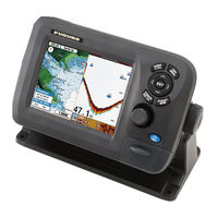
7" WIDE GPS/WAAS CHART PLOTTER
Brand:
Furuno
| Category:
GPS
| Size: 0.98 MB
Advertisement
Advertisement
Related Products
Furuno GP-1870F
Furuno GP-150
Furuno GP-1610C
Furuno GP-1670
Furuno GP-1670F
Furuno GP-150-Dual
Furuno GPS Plotter GP1600
Furuno GP-170
Furuno GP-1640
Furuno GP150D
Furuno Categories
Marine Radar
Marine Equipment
Sonar
Monitor
GPS
More Furuno Manuals
Login
Sign In
OR
Sign in with Facebook
Sign in with Google
Upload manual
Upload from disk
Upload from URL