Table of Contents
Advertisement
Quick Links
Download this manual
See also:
Quick Manual
Advertisement
Table of Contents
Troubleshooting

Related Manuals for Furuno GP-1670


Summary of Contents for Furuno GP-1670
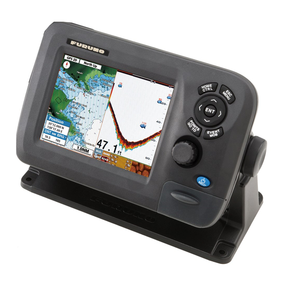
- Page 1 GPS PLOTTER GP-1670/GP-1870 Model www.furuno.com...
- Page 2 ・FURUNO Authorized Distributor/Dealer 9-52 Ashihara-cho, Nishinomiya, 662-8580, JAPAN A : JUN 2012 Printed in Italy All rights reserved. C2 : DEC . 10, 2013 Pub. No. OME-44760-C2 ( DAMI ) GP-1670/GP-1870 0 0 0 1 7 6 5 8 7 1 2...
-
Page 3: Important Notices
How to discard a used battery Some FURUNO products have a battery(ies). To see if your product has a battery, see the chapter on Maintenance. Follow the instructions below if a battery is used. Tape the + and - terminals of battery before disposal to prevent fire, heat generation caused by short circuit. -
Page 4: Safety Instructions
Electrical shock can result. power at the switchboard and contact a FURUNO service technician. Use the proper fuse. Electrical current flows to the pins of Use of the wrong fuse can cause fire or the transducer connector when the electrical shock. - Page 5 SAFETY INSTRUCTIONS CAUTION Do no turn on the equipment with the transducer out of water. The transducer can be damaged. The picture is not refreshed when picture advancement is stopped. Maneuvering the vessel in this condition can result in a dangerous situation. Adjust the gain correctly.
-
Page 6: Table Of Contents
TABLE OF CONTENTS FOREWORD .........................viii SYSTEM CONFIGURATION ...................x EQUIPMENT LISTS ......................xi OPERATIONAL OVERVIEW .................1-1 1.1 Controls........................1-1 1.1.1 Control description ..................1-1 1.2 RotoKey and Soft Controls ..................1-5 1.3 How to Turn the Power On or Off................1-6 1.4 How to Adjust the Display Brilliance................1-6 1.5 2D Plotter Displays..................... - Page 7 TABLE OF CONTENTS 3.2.3 How to enter a position manually on the plotter screen .........3-3 3.2.4 How to enter a point from the Points List ............3-3 3.3 How to Find Detailed Point Information ..............3-4 3.4 How to Move a Point ....................3-4 3.4.1 How to move a point on the screen..............3-4 3.4.2...
- Page 8 TABLE OF CONTENTS 6.3 3D Display........................6-6 6.3.1 3D display description ..................6-6 6.3.2 How to tilt and rotate the 3D display .............. 6-7 6.3.3 How to make the 3D view clearer ..............6-7 6.4 Satellite Photo Overlay....................6-8 ALARMS ........................7-1 7.1 ALARMS Menu ......................
- Page 9 TABLE OF CONTENTS 11. MAINTENANCE, TROUBLESHOOTING ............11-1 11.1 Maintenance ......................11-1 11.2 How to Replace the Fuse ..................11-2 11.3 Troubleshooting......................11-2 11.4 GPS Status Display ....................11-3 11.5 How to Restore Defaults, Clear Memory ..............11-4 11.6 System Information....................11-5 12. INSTALLATION ....................12-1 12.1 Installation of Display Unit ..................12-1 12.2 Installation of Antenna Unit..................12-2 12.3 Wiring ........................12-3 12.4 Initial Settings ......................12-6...
-
Page 10: Foreword
Thank you for considering and purchasing FURUNO equipment. Features The GP-1670 and GP-1870 provide a totally integrated GPS receiver and color video plotter. The built-in GPS receiver provides highly accurate position, course and speed information. The com- pact display unit and optional antenna unit permit installation where space is limited. - Page 11 FOREWORD • DSC (Digital Selective Calling) function alerts to DSC messages received and position re- quests. (Requires DSC capable radiotelephone.) Open Source Acknowledgement This product makes use of the following open source software: FreeType (www.freetype.org) Portions of this software are copyright ©2009 The FreeType Project (www.freetype.org).
-
Page 12: System Configuration
Display unit Protected from the weather GPS antenna unit Exposed to the weather, or protected from the weather in case of internal antenna Other units Protected from the weather GP-1670 Antenna Unit GPA-017 or GPA-017S Display Unit GP-1670F CAN bus... -
Page 13: Equipment Lists
000-021-070 1 set w/CP14-07101, MJ-A3SPF0013A- Materials 035C (power cable) Spare Parts SP14-03501 001-184-710 1 set Accessories FP14-03001 001-184-730 1 set For GP-1670 FP14-03201 001-183-120 1 set For GP-1870 Optional equipment Name Type Code no. Remarks Replacement Kit OP14-72 001-184-750 Waterproofing Cap... - Page 14 EQUIPMENT LISTS Name Type Code no. Remarks Cable Assy. M12-05BM+05BF-060 001-105-770-10 w/connectors (light), 6 m Cable Assy. M12-05BFFM-010 001-105-780-10 w/connectors (light), 1 m Cable Assy. M12-05BFFM-020 001-105-790-10 w/connectors (light), 2 m Cable Assy. M12-05BFFM-060 001-105-800-10 w/connectors (light), 6 m Cable Assy. CB-05PM+05BF-010 000-167-968-10 w/connectors (heavy), 1 m...
-
Page 15: Operational Overview
1.1.1 Control description The controller for this system is either the GP-1670 or the GP-1870. A key that has two text labels has two functions. The top label is the main function and the bottom label is the secondary function. Short-push to access the main function and long-push (approximately three seconds) to access the secondary function. - Page 16 1. OPERATIONAL OVERVIEW Control Description Short push: Display the base RotoKey soft controls for the current RotoKey mode. Long push: Display the full RotoKey soft controls for the current mode. Rotate: Zoom in or out the display range for the chart. Select a menu item.
- Page 17 1. OPERATIONAL OVERVIEW Tested SD cards The SD cards tested for use in this equipment are listed in the table below. Size Maker, Type 2 GB 4 GB 8 GB 16 GB 32 GB ADTEC AD-SDH (SD) [AD-SDH2G] BUFFALO RSDC-S (SD) [RSDC-S2G] RSDC-G Hi-Performance (SD) [RSDC-G2G] Hagiwara System T series (SD) [PSDB0487A]...
- Page 18 1. OPERATIONAL OVERVIEW Size Maker, Type 2 GB 4 GB 8 GB 16 GB 32 GB San Disk SanDisk (SD) [SDSDB-2048-J60] SanDisk (SDHC) [SDSDBR-4096-J85] SanDisk Ultra II (SDHC) CLASS 4 [SDSDRH-8192-903] SanDisk Ultra II (SD) [SDSDH-2048-903] SanDisk Ultra II (SDHC) [SDSDRH-4096-903] SanDisk Extreme III (SDHC) [SDSDRX3-4096-903] SanDisk Extreme (SDHC) [SDSDX3-016G-J31A] SanDisk Extreme (SDHC) [SDSDX3-032G-J31A]...
-
Page 19: Rotokey Tm And Soft Controls
1. OPERATIONAL OVERVIEW RotoKey and Soft Controls The main function of the RotoKey is to display the RotoKey menu, a set of revolving soft controls that change with the operating mode. There are two sets of RotoKey menus: base and full. A short push of the key shows the base set for the current mode, and a long push displays the full compliment of soft controls for the current mode. -
Page 20: How To Turn The Power On Or Off
1. OPERATIONAL OVERVIEW How to Turn the Power On or Off To turn the power ON, press approx two seconds. Release when the FURUNO logo appears. It takes approx. 25-30 seconds to start the system, in the sequence shown below. - Page 21 1. OPERATIONAL OVERVIEW 2D plotter display, vector chart A vector chart is a series of points and lines that make up the features on a chart. Vec- tor charts look computer generated. Details on the chart can be turned on and off. Ob- jects on the chart can be clicked on to learn more details.
- Page 22 1. OPERATIONAL OVERVIEW 2D plotter display, vector/satellite The vector chart plus a satellite photo. See chapter 6 for how to adjust the satellite dis- play. 2D plotter display, raster A raster chart is a direct copy or scan of an existing paper chart. Raster charts look identical to paper charts.
-
Page 23: The Cursor
1. OPERATIONAL OVERVIEW The Cursor The cursor has the functions shown below. • Find, when put on respective item: • Position, range and bearing to cursor location • Point information • Route information • Track information • AIS target information •... -
Page 24: Navigation Data Boxes
1. OPERATIONAL OVERVIEW Navigation Data Boxes The navigation data boxes, displayed at the bottom of the screen, show various navi- gation data fed from the sensors connected to the display unit. Two or four boxes can be displayed and you can freely change the data shown in each box. The data that you can show depends on your system configuration. -
Page 25: Home Screen (Display Selection)
1. OPERATIONAL OVERVIEW Home Screen (Display Selection) 1.8.1 How to select a display The home screen has eight displays from which to choose. Press the HOME/CTRL key to show the home screen. Operate the CursorPad or rotate the RotoKey select a display. The current selection is circumscribed with a red rectangle. Press the RotoKey or ENT key to confirm your selection. -
Page 26: How To Customize The Home Screen
1. OPERATIONAL OVERVIEW 1.8.3 How to customize the home screen The home screen has seven screens that you can customize. (The full-screen plotter display cannot be customized. If you try to customize this display, the message “Can’t customize this display.” appears.) You can split the screen in up to four separate seg- ments. - Page 27 1. OPERATIONAL OVERVIEW 5. Select a display then push the RotoKey . For example, select the plotter dis- play. The chosen display appears at the location selected and the rectangle cur- sor moves to the adjacent screen. 6. Select a display for the right half then push the RotoKey .
-
Page 28: Description Of Home Screen Displays
1. OPERATIONAL OVERVIEW 1.8.4 Description of home screen displays Full screen displays Plotter: See page 1-7. Tide & Celestial: Your plotter provides for calculation of the tide heights for any date. Additionally this display shows the time of sunrise, sunset, moonrise and moonset. See section 1.17. - Page 29 1. OPERATIONAL OVERVIEW Wind meter+navigation data x2: The wind meter provides analog and digital indications of wind angle. The wind meter is fixed; however, the two boxes of navigation data can be changed. Meter+navigation data x2: This display provides a meter plus two navigation data boxes.
- Page 30 1. OPERATIONAL OVERVIEW Quarter screens The figure below shows the available quarter screens. Like with the half screens you can select the navigation data to display in a quarter screen. Navigation data x1 Navigation data x2 Navigation data x3 Navigation data x4 Steering Wind angle Meter x1 (ex.
- Page 31 1. OPERATIONAL OVERVIEW How to select the data to display in a quarter screen, half screen navigation data 1. Display a home screen that has a quarter screen or a half screen with navigation data. 2. Long press the HOME/CTRL key to select the data display to change.
-
Page 32: Display Range
1. OPERATIONAL OVERVIEW Display Range You can change the chart scale to change the amount of in- formation shown, or zoom in or out at the location you select, in the plotter and steering displays. The selected chart scale appears at the bottom right-hand position on the screen. The 20 NM available ranges depends on latitude and chart area. -
Page 33: How To Move The Chart
1. OPERATIONAL OVERVIEW Auto course-up: The course or heading is at the top of screen at the moment the auto course-up mode is selected. PT00001 5 NM 1.11 How to Move the Chart Move the chart in the following conditions. •... -
Page 34: Menu Operation
1. OPERATIONAL OVERVIEW 1.12 Menu Operation This section shows you how to operate the menu. There are eight menus, [General], [Map], [Plotter], [Alarms], [System], [Instruments] and [Interface]. 1. Long-push the ESC/MENU key to show the main menu. 2. Rotate the RotoKey to select a menu then push the key or the ENT key to dis- play that menu. -
Page 35: Object Information
• Point: [DETAILED] • Route: [INFO] • Chart object: [FULL INFO] Name PT0001 Position 34º41.006N The right figure shows detailed information for a 135º41.629E point. Time 02-24-12 12:46PM Temp 11.3º Depth 85.7 m Comment FURUNO Detailed point information 1-21... -
Page 36: Context-Sensitive Menus
1. OPERATIONAL OVERVIEW 1.14 Context-Sensitive Menus The context-sensitive menus let you quickly access the functions related to the cursor- selected item. Select an applicable item then press the ENT key to show the related context-sensitive menu. Use the RotoKey to select a function. The table below shows the context-sensitive menus available in each category. - Page 37 1. OPERATIONAL OVERVIEW Item Context-sensitive menu Description Route [STOP]: Stop navigating the active route. STOP (active) [RESTART]: Restart navigating the active route. RESTART [REVERSE]: Follow the points in the active route in reverse order. REVERSE [INSERT]: Add a new point to the cursor position INSERT of the active route.
-
Page 38: Man Overboard (Mob)
1. OPERATIONAL OVERVIEW Item Context-sensitive menu Description Screenshots [SAVE]: Copy the screenshots in the internal SAVE (INTERNAL) memory to the SD card. DELETE [DELETE]: Delete the screenshots. RENAME [RENAME]: Give the file a new name. PREVIEW [PREVIEW]: Show the screenshots selected on the screen. -
Page 39: Tide Information
1. OPERATIONAL OVERVIEW 1.17 Tide Information Your chart contains worldwide tide height and tidal current information. 1.17.1 Tide height information The tide station symbol appears at the locations of tide height recording stations. To get tide information from a tide station, put the cursor on the tide station symbol, press the ENT key then select [FULL INFO] from the context-sensitive menu to show the [OBJECTS] menu. -
Page 40: Tide Stream Information
1. OPERATIONAL OVERVIEW 1.17.2 Tide stream information This page is intentionally left blank. The tidal stream information is made from the tide stream data received from tide stream station. Tidal streams are marked with arrows. The size and color of the arrow indicate tide stream speed, Yellow, slow;... -
Page 41: Track
TRACK Your boat’s track is plotted on the display with position information fed from the inter- nal GPS navigator. This section shows you how to process track, from how to show or hide the track to how to change its color. How to Show, Hide all Track By soft control: Open the RotoKey menu then select [Track] to toggle the track dis- play ON and OFF. -
Page 42: How To Change The Color Of Your Boat's Track
2. TRACK How to Change the Color of Your Boat’s Track You can select the color for your boat’s track among red, green, light green, yellow, purple, orange, brown, and black. It is useful to change the color at regular intervals to distinguish tracks at different times of a day, for example. -
Page 43: How To Delete Track By Color
2. TRACK How to Delete Track by Color When the screen becomes cluttered with track, you may want to delete some track to clear up the display. You can delete track from the context-sensitive menu or the menu. How to delete track color from the menu 1. - Page 44 2. TRACK This page is intentionally left blank.
-
Page 45: Points
POINTS What is a Point? In navigation terminology, a point is any location you mark on the plotter display. A point can be a fishing spot, reference point and other important locations. You can use a point you have entered to set a destination and create a route. This unit has 30,000 points into which you can enter position information. -
Page 46: How To Enter A Point At The Cursor Position
3. POINTS 3.2.2 How to enter a point at the cursor position 1. Operate the CursorPad to put the cursor where desired then press the POINTS/ GOTO key. The “point” pop-up appears and shows point name, latitude and longitude position of the point, and distance and bearing to the point. -
Page 47: How To Enter A Position Manually On The Plotter Screen
3. POINTS [Hide]: Hide the icon and its name. [Icon]: Show only the icon. 8. Use [Comment] to enter a comment about the point, with the CursorPad. The de- fault comment is the time and date of entry of the point. A comment may have a maximum of 64 alphanumeric characters. -
Page 48: How To Find Detailed Point Information
3. POINTS How to Find Detailed Point Information You can find detailed point information with the point information pop-up. Put the cur- sor on the point then press the ENT key. (A point is correctly selected if the “point” box appears. -
Page 49: How To Select Visibility For Points
3. POINTS How to Select Visibility for Points Points can be shown or hidden individually or collectively. 1. Open the [PLOTTER] menu and select [POINTS] to show the [Points List]. 2. Select the point to edit then press the ENT key. Note: If you want to assign visibility globally, select any point. -
Page 50: How To Filter Points By Shape On The Points List
3. POINTS How to Filter Points by Shape on the Points List You may filter points on the [Points List] by icon shape. This is useful when you are looking for points of a specific shape. 1. Open the [PLOTTER] menu and select [POINTS] to show the [Points List]. 2. -
Page 51: Routes
ROUTES What is a Route? Often a trip from one place to another involves several course changes, requiring a series of route points (waypoints) which you navigate to, one after another. The se- quence of waypoints leading to the ultimate destination is called a route. The equip- ment can store 1,000 routes, with a maximum of 50 points per route. -
Page 52: How To Create A Route From The Routes List
4. ROUTES 4.2.2 How to create a route from the Routes List A route can also be created from the [Routes List], with the points you have entered. 1. Open the [PLOTTER] menu and select [ROUTES] to show the [Routes List]. 2. -
Page 53: How To Create A Route With The Easy Routing Feature
Always remember that you should navigate with the most detailed and up-to-date chart available from FURUNO, and new information from National Hydrographic Offices may render your charts obsolete at any time. - Page 54 4. ROUTES How to set the safe values for Easy Routing Follow the procedure below to set the safe values to use in Easy Routing. 1. Open the [PLOTTER] menu and select [EASY ROUTING]. 6.6 ft 39.4 ft 0.0022 NM 5.0 min 2.
- Page 55 4. ROUTES 4. Select [EASY ROUTING] followed by [DESTINA- TION]. ER CALCULATING The destination point is marked with a green flag, Calculating route labeled [ER DEST]. Please wait 5. Press the ENT key then select [EASY ROUTING] followed by [CALCULATE]. A warning about the use of easy routing appears.
-
Page 56: How To Extend A Route On The Screen
4. ROUTES Error messages in Easy Routing Error message Meaning Remedy Latitude of the defined points is The latitude of the points is over Reselect the points. greater than 80°. Route has not 80°N/S. been calculated. No charts with Easy Routing You tried to use Easy Routing Insert appropriate chart card. -
Page 57: How To Insert A Point On A Route On The Screen
4. ROUTES How to Insert a Point on a Route on the Screen You can put a point between route legs when you need an additional point along a route. 1. Put the cursor on a leg of the route. 2. -
Page 58: Routes List
4. ROUTES Routes List 4.7.1 How to display the Routes List The [Routes List] shows all the routes saved to the internal memory. To show the [Routes List], open the [PLOTTER] menu and select [ROUTES]. Use the up and down arrows on the CursorPad to scroll the list. For multiple pages, switch between pages with the right and left arrows on the CursorPad. - Page 59 4. ROUTES Route editing function buttons The route editing function buttons appear at the bottom of the screen when a route is selected for editing. Select the route from the [Routes List] then press the ENT key to show the context-sensitive menu. Select [EDIT] from the context-sensitive menu then press the ENT key.
-
Page 60: Route Report, Route Calculator
4. ROUTES Route Report, Route Calculator A route report provides detailed information about a route plus a route navigation cal- culator. The route navigation calculator lets you see the time necessary to travel to each leg and the amount of fuel required for each leg with various speeds and fuel consumption figures. -
Page 61: How To Display A Route On The Screen
4. ROUTES How to Display a Route on the Screen Open the [PLOTTER] menu and select [ROUTES] to show the [Routes List]. Select a route then press the ENT key. Select [PLOT] from the context-sensitive menu then press the ENT key. 4.10 How to Connect Two Routes You can connect two routes from the [Routes List]. -
Page 62: How To Rename A Route On The Screen
4. ROUTES 4.12 How to Rename a Route on the Screen The default name for a route is RTXXXX (XXXX=route number). If desired, you can rename the route with one more descriptive. 1. Put the cursor on the route to rename then press the ENT key. 2. -
Page 63: Navigation
NAVIGATION This chapter shows you how to get to a desired destination by using “quick points,” saved points, and routes. Before you go to a point or follow a route, make sure the path to the points is clear. Zoom your chart to check for hazards which appear on a smaller scale. How to Navigate to a Quick Point The advantage of navigating to a quick point, the cursor position, is that you do not need to save the point to the memory. -
Page 64: How To Navigate To A Saved Point
Arrival area (red) Point (yellow by XTE alarm line default) (red) FURUNO Ship icon Navigation line Point (red) name 5.2.2 How to navigate to a point selected from the Points List 1. -
Page 65: Route Selected From The Routes List
5. NAVIGATION • A red line runs between the points on the route. The line shows the shortest path to the destination and the direction to go. Route point Arrival area (red) (yellow by default) PT00003 PT00002 XTE alarm line (red) PT00001 Navigation line... -
Page 66: Functions Available When You Follow A Route
5. NAVIGATION Functions Available When You Follow a Route 5.4.1 Restart navigation When you follow a route, you can restart the navigation to the next point on the Line 2 route from current location. When you steer to keep away from an ob- struction or your boat drifts, you go off course, like shown with Line 1 in the fig- ure. -
Page 67: Map Settings, 2D Perspective/3D Displays And Satellite Overlay
MAP SETTINGS, 2D PERSPEC- TIVE/3D DISPLAYS AND SATELLITE OVERLAY This chapter shows you how to set up the map display and how to select the 2D per- spective and 3D displays. Map Setup All map settings are in the [MAP] menu. On this menu you can •... - Page 68 6. MAP SETTINGS, 2D PERSPECTIVE/3D DISPLAYS AND SATELLITE OVERLAY [CHART LANGUAGE]: Use [Language] to select the chart language to use to show chart information (place names, etc.), among English and major European and Asian languages. Use [Mode] to select what language to display chart information in. [Off]: Chart information is shown in English when it is not available in the chart lan- guage selected.
- Page 69 6. MAP SETTINGS, 2D PERSPECTIVE/3D DISPLAYS AND SATELLITE OVERLAY DIsplay Level Item Available Settings Full Medium Tides MARINE SETTINGS NAMES On, Off HAZARD AREAS LA- On, Off BELS NAV-AID NAMES On, Off PORT NAMES On, Off NAV AIDS &LIGHT SEC- No sector No sector On, Off, No sector...
- Page 70 6. MAP SETTINGS, 2D PERSPECTIVE/3D DISPLAYS AND SATELLITE OVERLAY [FIND]: The find feature helps you locate ports, tide stations, wrecks, obstructions, and points of interests (attractions, medical service, entertainment, shopping, etc.). [COORDINATES] puts the cursor on the position you enter. For example, select [PORT BY DISTANCE] to find the ports closest to your current position.
-
Page 71: Perspective Display
6. MAP SETTINGS, 2D PERSPECTIVE/3D DISPLAYS AND SATELLITE OVERLAY 2D Perspective Display The 2D perspective display provides an aerial perspective display. Select [2D/3D] Mode and [2D Perspective] from the RotoKey menu to show this display. 2D display 2D perspective display... -
Page 72: Display
6. MAP SETTINGS, 2D PERSPECTIVE/3D DISPLAYS AND SATELLITE OVERLAY 3D Display 6.3.1 3D display description The 3D display has native 3D chart design that allows full time 3D presentation. This true 3D environment gives you all of the information you require with no restrictions on the information you can see. -
Page 73: How To Tilt And Rotate The 3D Display
6. MAP SETTINGS, 2D PERSPECTIVE/3D DISPLAYS AND SATELLITE OVERLAY 6.3.2 How to tilt and rotate the 3D display To tilt and rotate the 3D display, first select [Mode] and [Manual] from the RotoKey menu. [Manual] appears in the orientation mode box. Long-push the ENT key to en- able adjustment. -
Page 74: Satellite Photo Overlay
6. MAP SETTINGS, 2D PERSPECTIVE/3D DISPLAYS AND SATELLITE OVERLAY Satellite Photo Overlay You can overlay the satellite photo for your area on the 2D and 3D displays. Open the RotoKey menu then select [2D/3D Mode], [2D] or [3D] and [Vector/Satellite] to show the satellite photo. -
Page 75: Alarms
ALARMS The plotter section has 11 alarms that release audiovisual alarms when the specified conditions are met. These are • Anchor alarm • Arrival alarm • Black water tank alarm • Depth alarm • Fuel tank alarm • Shear alarm •... -
Page 76: Audio Alarm Conditions
7. ALARMS Audio Alarm Conditions The audio alarm can be enabled or disabled and the alarm interval selected. 1. Open the [ALARMS] menu then select [AUDIBLE ALARM]. 2. Select [Off] or [On] as appropriate. 3. Select [INTERVAL]. 4. Select the alarm interval desired, among [Short] or [Long]. 5. -
Page 77: Xte Alarm
7. ALARMS XTE Alarm The XTE (cross-track error) alarm warns you when your boat is off its intended course. You must set a destination to use this alarm. Own ship Destination Alarm position waypoint setting Intended course : Alarm area To set the XTE alarm: 1. -
Page 78: Shear Alarm
7. ALARMS Shear Alarm The shear alarm, which requires water temperature data, sounds when the tempera- ture exceeds the value set. To set the shear alarm: 1. Open the [ALARMS] menu then select [SHEAR ALARM]. 2. Confirm that the cursor is selecting the top line then push the RotoKey 3. -
Page 79: Anchor Alarm
7. ALARMS Anchor Alarm The anchor alarm informs you that your boat is moving when it should be at rest. Own ship position Alarm range : Alarm area To set the anchor alarm: 1. Open the [ALARMS] menu then select [ANCHOR ALARM]. 2. -
Page 80: Fuel Tank Alarm
7. ALARMS 7.11 Fuel Tank Alarm The fuel tank alarm warns you when the fuel level goes below the specified percent- age. To set the fuel tank alarm: 1. Open the [ALARMS] menu then select [FUEL TANK]. 2. Confirm that the cursor is selecting the top line then push the RotoKey 3. -
Page 81: Memory Card Operations
MEMORY CARD OPERATIONS This system uses SD and SDHC cards to store points, routes, tracks, settings, and screenshots. The system accepts cards of up to 32GB in size. The Memory Card Screen Open the [GENERAL] menu and select [MEMORY CARD] to show the [MEMORY CARD] screen. -
Page 82: How To Eject An Sd Card
8. MEMORY CARD OPERATIONS How to Eject an SD Card To prevent loss of data on an SD card, eject the SD card from the RotoKey menu. Open the Full RotoKey menu then select [Eject SD]. After ejecting the SD card, close the cover. -
Page 83: How To Delete Files From An Sd Card
8. MEMORY CARD OPERATIONS How to Delete Files from an SD Card 8.6.1 How to delete individual files from an SD card 1. Open the [GENERAL] menu and select [MEMORY CARD]. 2. Select the appropriate tab at the top of the screen then press the ENT key. 3. -
Page 84: How To Process Screenshots
8. MEMORY CARD OPERATIONS How to Process Screenshots The [Screenshots] tab process the screenshots saved to the memory and SD cards. You can save screenshots saved in the internal memory to the SD card and delete screenshots from both the internal memory and an SD card. 8.8.1 How to select source of screenshots (internal memory or SD card) -
Page 85: How To Delete Screenshots
8. MEMORY CARD OPERATIONS 8.8.3 How to delete screenshots How to delete individual screenshots 1. Open the [GENERAL] menu and select [MEMORY CARD]. 2. Select the [Screenshots] tab at the top of the screen then press the ENT key. 3. Select the SD card or internal memory as applicable. See section 8.8.1. 4. - Page 86 8. MEMORY CARD OPERATIONS This page is intentionally left blank.
-
Page 87: Other Functions
OTHER FUNCTIONS AIS Operations AIS (Automatic Identification System) is a system that continuously transmits the iden- tification and position of your boat to AIS transponder equipped vessels within com- municating range. All such vessels also receive data from other AIS transponder equipped vessels and display their positions and other relevant information. -
Page 88: How To Find Ais Target Information
9. OTHER FUNCTIONS 9.1.2 How to find AIS target information Put the cursor on an AIS target symbol to show AIS target information. Name FURUNO Latitude 34°39.0413N Longitude 135°21.8571E MMSI 456342110 Call Sign 1AB23 15.3 kn 234°T 235°T 3.28 NM... -
Page 89: Dsc Message Information
9. OTHER FUNCTIONS DSC Message Information The DSC (Digital Selective Calling) message information feature alerts you when you have received a DSC position request or a DSC distress call, via an SSB radiotele- phone. The icon marks the position of the vessel that sent the request or call on the plotter display, at the time the message was sent. -
Page 90: Stopwatch, Timer
9. OTHER FUNCTIONS Stopwatch, Timer A stopwatch or timer is available on a navigation data display. (The stopwatch and timer cannot be used simultaneously.) The stopwatch counts elapsed time and the timer counts down the time from a specified time interval. To enable the stopwatch or timer, do the following. -
Page 91: How To Select Input, Output Data
[Auto]: Select when multiple external sources are avail- PERATURE] and [SPEED able. In this case, the device with the lowest IP address THROUGH WATER] has priority. If the source is a FURUNO make, its name appears be-low [Auto]. Select it to have that device feed respective data. -
Page 92: Output Data
9. OTHER FUNCTIONS 9.4.2 Output data Open the [INTERFACE] menu and select [SELECT OUTPUT PGN]. Select the item to process. Select [On] or [Off] as appropriate. Scroll... -
Page 93: Engine Display Setup (Instruments Menu)
9. OTHER FUNCTIONS Engine Display Setup (INSTRUMENTS menu) Set your engine’s specifications on the [INSTRUMENTS] menu to get correct informa- tion on the engine displays. 80° to 320°F 80° to 320°F 80° to 320°F Item Options Remarks ENGINE RPM 4000, 6000, 8000 rpm Set max. - Page 94 9. OTHER FUNCTIONS This page is intentionally left blank.
-
Page 95: 10. Customizing Your Unit
10. CUSTOMIZING YOUR UNIT The default settings are suitable for a wide variety of applications. However, you may wish to customize settings to meet your environment, operational needs, local char- acteristics, etc. This chapter provides descriptions of the menu items not previously described, to help you determine the settings right for you. -
Page 96: Plotter Menu
10. CUSTOMIZING YOUR UNIT 10.2 PLOTTER Menu [COG LINE]: The tip of the COG line is your estimated position at the end of the time interval selected here. The COG line can be a valuable tool for evaluating the risk of collision with another vessel if AIS targets are displayed. -
Page 97: System Menu
10. CUSTOMIZING YOUR UNIT 10.3 SYSTEM Menu [LANGUAGE]: Select the language among English and major European and Asian languages. [UNITS OF MEASURE]: The default units of measure are based on the language se- lected. However, you can freely set the units of measure for distance, speed, wind speed, depth, temperature, air pressure, oil pressure, and fuel. - Page 98 10. CUSTOMIZING YOUR UNIT from the GPS satellite. The raw velocity data may change randomly depending on re- ceiving conditions and other factors. You can reduce this random variation by increas- ing the filter setting. Like with the latitude and longitude filter, the higher the speed filter setting the more smoothed the raw data.
- Page 99 10. CUSTOMIZING YOUR UNIT tion engine to the expected application environment. [Low] corresponds to pedestrian dynamic platform model. For applications with low acceleration and speed. [High] cor- responds to at sea dynamic platform model. Recommended for applications at sea. [DIFFERENTIAL CORRECTION]: The correction is made with SBAS (WAAS, EG- NOS, MSAS).
- Page 100 10. CUSTOMIZING YOUR UNIT This page is intentionally left blank. 10-6...
-
Page 101: Maintenance, Troubleshooting
11. MAINTENANCE, TROUBLESHOOTING This section provides maintenance and troubleshooting procedures that the user can follow to get optimum performance from the equipment. Before attempting any main- tenance or troubleshooting procedure please review the safety information below. If you cannot restore normal operation after following the troubleshooting procedures do not attempt to check inside the equipment;... -
Page 102: How To Replace The Fuse
11. MAINTENANCE, TROUBLESHOOTING 11.2 How to Replace the Fuse The fuse (3A, Type: FGBO-A 125V 3A PBF, Code No.: 000-155-850-10) in the fuse holder on the power cable protects the display unit from high electric current and equipment fault. If you cannot turn on the power, check the fuse to see if it has blown. If the fuse has blown, find the reason before you replace the fuse. -
Page 103: Gps Status Display
11. MAINTENANCE, TROUBLESHOOTING 11.4 GPS Status Display The GPS status display shows the RX signal strength and the location of each GPS satellite received. By default, the GPS status display is provided on a home screen. GPS 3D Description of GPS status display •... -
Page 104: How To Restore Defaults, Clear Memory
11. MAINTENANCE, TROUBLESHOOTING 11.5 How to Restore Defaults, Clear Memory You may wish to restore default or user settings. 1. Open the [SYSTEM] menu then select [DEFAULT SETTINGS]. 2. Select one of the following according to your objective. [FACTORY DEFAULT]: Restore all default factory settings. User-saved items (waypoint, routes, etc.) are not erased. -
Page 105: System Information
11. MAINTENANCE, TROUBLESHOOTING 11.6 System Information The system information display, for use by the service technician, shows chart oper- ating system information, license information and the data access manager report. Open the [SYSTEM] menu and select [SYSTEM INFORMATION] to show the charting operating system display. - Page 106 11. MAINTENANCE, TROUBLESHOOTING This page is intentionally left blank. 11-6...
-
Page 107: 12. Installation
12. INSTALLATION 12.1 Installation of Display Unit Mounting considerations The display unit can be installed on a tabletop or flush mounted in a console. Select a suitable mounting location considering the following: • Keep the display unit out of direct sunlight. •... -
Page 108: Installation Of Antenna Unit
12. INSTALLATION 12.2 Installation of Antenna Unit Mounting considerations The antenna unit GPA-017/017S (option) is available for receiving GPS signal with far- ther sensitivity. Select a suitable mounting location considering the following: • Select a location out of the radar beam. The radar beam will obstruct or prevent re- ception of the GPS satellite signal. -
Page 109: Wiring
12. INSTALLATION 12.3 Wiring All wiring are terminated at the rear of the display unit. Refer to the interconnection diagram on page S-1. Display unit (back) No use WARNING ELECTRICAL SHOCK CAN bus equipment DO NOT touch the pins inside the connector. - Page 110 12. INSTALLATION GPS antenna unit (option) Connect the antenna cable to the GPS connector. How to attach the M-P-8DFB connector Dimensions in millimeters. Outer sheath Armor Inner sheath Shield Remove outer sheath and armor by the dimensions shown left. Expose inner sheath and shield by the dimensions shown left. Cover with heat-shrink tubing and heat.
- Page 111 All the CAN bus devices can be incorporated into the NMEA2000 network. For detailed information about CAN bus wiring, see “FURUNO CAN bus Network Design Guide” (Type: TIE-00170) on Tech-Net), or contact your dealer.
-
Page 112: Initial Settings
12. INSTALLATION 12.4 Initial Settings 12.4.1 INSTALLATION SETTINGS menu The first time the system is powered, the [INSTALLATION SETTINGS] menu appears. Enter basic settings, following the procedure below. 1. If your language is English USA, the default language, go to step 4. 2. - Page 113 12. INSTALLATION 4. Rotate the RotoKey to select [UNITS OF MEASURE] then push the key. The units of measure are automatically changed according to the language select- ed. The available units are as shown in the table below. Item Available units Item Available units DISTANCE...
-
Page 114: Can Bus Input/Output
GPS. In this case, the navigator with the low- est IP address has priority. If you have a FURUNO external navigator speed/course source connected, its name appears below [Auto]. Select the model name to have that device feed corresponding data. - Page 115 12. INSTALLATION If the external source is a FURUNO make, its name appears below [Auto]. Se- lect the device name to have the device feed respective data. 4) Other items are selected to [Auto]. Respective data are input if associated de- vice is connected to the system.
- Page 116 12. INSTALLATION Description 127488 Engine Parameters, Rapid Update 127489 Engine Parameters, Dynamic 127493 Transmission Parameters 127496 Trip Parameter, Vessel 127505 Fluid Level 128259 Speed 128267 Water Depth 129025 Position, Rapid Update 129026 COG & SOG, Rapid Update 129029 GNSS Position Data 129033 Time &...
- Page 117 12. INSTALLATION Output PGN Description Output cycle (msec) 059392 ISO Acknowledgement 059904 ISO Request 060928 ISO Address Claim 126208 NMEA-Request Group Function NMEA-Command Group Function NMEA-Acknowledge Group Function 126464 Transmit PGN’s Group Function System Time 1000 126992 126996 Production Information Magnetic Variation 1000 127258...
- Page 118 12. INSTALLATION This page is intentionally left blank. 12-12...
-
Page 119: Appendix 1 Menu Tree
APPENDIX 1 MENU TREE ESC/MENU GENERAL KEYPAD BEEP (On, Off) (long press) PALETTE (Sunlight, Night, Normal) FONT SIZE (Large, Small) TIME OFFSET (UTC) DAYLIGHT SAVING TIME (On, Off) TIME FORMAT (12 Hours, 24 Hours) DATE FORMAT (MM-DD-YY, DD-MM-YY) MEMORY CARD (SD card operations) ICON SIZE (Standard, Large) PLACE NAMES SIZE (Standard, Medium, Large) NAV AIDS PRESENTATION (US, International) - Page 120 APPENDIX 1 MENU TREE (Con’t from previous page) Standard land VAD - [Free Value Added Data] DISPLAY (On, Off, Custom) CUSTOMIZE Road (On, Off) Land Elevation (On, Off) Standard Marine VAD - [Free Value Added Data] DISPLAY (On, Off, Custom) CUSTOMIZE Tide height station (On, Off) Port/Marina (On, Off)
- Page 121 APPENDIX 1 MENU TREE (Con’t from previous page) LANGUAGE (English, others) SYSTEM UNITS OF DISTANCE (NM, SM, km, NM+ft, NM+m, SM+ft) MEASURE SPEED (kn, mph, km/h) WIND SPEED (kn, m/s, mph, Bft) DEPTH (m, ft, fm, pb, HR) TEMPERATURE (°F, °C) AIR PRESSURE (Bar, hPa) OIL PRESSURE (Bar, PSI, kPa) FUEL (l, UK gal, US gal)
- Page 122 APPENDIX 1 MENU TREE (Con’t from previous page) ENGINE RPM (4000RPM, 6000RPM, 8000RPM) INSTRU- MAX OIL PRESSURE (600kPa, 800kPa, 1000kPa) MENTS ENGINE BOOST PRESSURE (160kPa, 200kPa, 320kPa) ENGINE COOLANT PRESSURE (320kPa, 520kPa, 600kPa) FUEL PRESSURE (320kPa, 520kPa, 600kPa) ENGINE TEMPERATURE (80º to 320ºF, 120º to 400ºF) ENGINE OIL TEMPERATURE (80º...
-
Page 123: Appendix 2 Abbreviations, Symbols
APPENDIX 2 ABBREVIATIONS, SYMBOLS Abbreviations Abbreviation Meaning Two Dimensional Three Dimensional A-PRS Air Pressure A-TMP Air Temperature Automatic Identification System Ante Meridiem Atlantic Ocean Region AUTO Automatic B-type Bottom type Barometric Beaufort BIOS Basic Input/Output System BOOST Engine Boost Pressure Bearing Celsius C-TMP... - Page 124 APPENDIX 2 ABBREVIATIONS, SYMBOLS Abbreviation Meaning Fast File fathoms feet FUEL Fuel Rate FUEL-P Fuel Pressure FUEL-R Fuel Rate GAIN H Gain High (frequency) GAIN L Gain Low (frequency) gallon GNSS Global Navigation Satellite System Global Positioning System Heading HDOP Horizontal Dilution of Precision hour HOUR...
- Page 125 APPENDIX 2 ABBREVIATIONS, SYMBOLS Abbreviation Meaning Post Meridiem Pacific Ocean Region Position Per Square Inch Point Quick Point Resolution Rate Of Turn Route RUDDR Rudder South Secure Digital SDHC Secure Digital High capacity Software Development Kit second(s) Simulation Satellite statute mile Speed Over the Ground Speed Through Water Symbol...
- Page 126 APPENDIX 2 ABBREVIATIONS, SYMBOLS Symbols Plotter display symbols Item Symbol Cursor (two types) : Active : Inactive (red) MOB (ManOverBoard) mark (red) Ship icon (three types) Icon 1 Icon 2 Icon 3 Ship icon+COG line Ship icon+Heading line (red) Ship icon+track Point (single point and route point) (default: yellow) Alarm symbols...
- Page 127 EX: DPYCYSLA - 1.5 MPYC - 4 TTYCSLA-4 Core Area (mm # of cores Designation type Designation type The following reference table lists gives the measurements of JIS cables commonly used with Furuno products: Core Cable Core Cable Diameter Diameter...
-
Page 128: Appendix 3 Jis Cable Guide
APPENDIX 3 JIS CABLE GUIDE This page is intentionally left blank. AP-10... -
Page 129: Specifications
FURUNO GP-1670/1870 SPECIFICATIONS OF GPS PLOTTER GP-1670/1870 GENERAL Display GP-1670 5.7-inch TFT color LCD, 640 x 480 dots GP-1870 7.0-inch TFT color LCD, 800 x 480 dots Display mode Plotter, Video pilot, Highway, Waypoint display Projection Mercator Useable area 80° latitude or below... - Page 130 FURUNO GP-1670/1870 CAN bus PGN (NMEA2000) Input 059392/904, 060928, 061184, 126208/992/996, 127245/250/251/488/489/493/496/505, 128259/267, 129025/026/029/033/038/039/040/538/540/793/794/798, 129808/809/810, 130306/310/311/312/313/314/577 Output 059392/904, 060928, 126208/464/992/996, 127258, 128259/267/275, 129025/026/029/033/283/284/285, 130310/312/830 POWER SUPPLY Display unit GP-1670 12-24 VDC: 0.5-0.3 A GP-1870 12-24 VDC: 0.6-0.3 A Rectifier (PR-62, option) 100/110/115/220/230 VAC, 1 phase, 50/60Hz...
-
Page 138: Index
INDEX Numerics 2D perspective display .......6-5 Easy routing 2D plotter display description..........4-3 raster display..........1-8 error messages ........4-6 vector chart ..........1-7 safe values for..........4-4 vector/satellite ..........1-8 Engine display..........9-8 3D display description..........6-6 Fuel tank alarm ..........7-6 exaggeration ..........6-7 Fuse replacement ........11-2 tilt..............6-7 GENERAL menu ........10-1 GPS status display........11-3 activation range........9-2... - Page 139 INDEX saved point..........5-2 deleting............ 8-5 Navigation data boxes......1-10 selecting source of ........8-4 North-up ..........1-18 taking............. 1-24 Shear alarm..........7-4 Soft controls ..........1-5 Object information ........1-21 Speed alarm..........7-5 Orientation mode........1-18 Stopwatch ..........9-4 Output data ..........
- Page 140 When a claim is made, FURUNO has a right to choose whether with other electronic devices. The imported product may also be to repair the product or replace it.
- Page 141 24 months from installation date provided the work is done by Furuno U.S.A., Inc. or an AUTHORIZED Furuno dealer during normal shop hours and within a radius of 50 miles of the shop location.