
Related Manuals for Topcon ES-102


Summarization of Contents
How to Read This Manual
Symbols
Explains the meaning of various symbols used throughout the manual for clarity.
Notes regarding manual style
Provides guidance on manual conventions, instrument models, and illustration sources.
1. Precautions for Safe Operation
Definition of Indication
Defines warning, caution, prohibition, and mandatory symbols used for safety instructions.
2. Precautions
Charging Battery
Details battery charging precautions, temperature range, and charger usage.
Warranty policy for Battery
Explains battery lifespan and warranty limitations regarding normal wear and tear.
Bluetooth Wireless Technology
Notes on Bluetooth functionality availability and compliance with telecommunications regulations.
Tribrach Clamp
Describes the tribrach clamp's locking screw for securing the instrument during transport.
Precautions concerning water and dust resistance
Explains IP66 rating and precautions for maintaining waterproofing and dust resistance.
The Lithium Battery
Describes the lithium battery's role in maintaining calendar/clock functions and its approximate lifespan.
Vertical and horizontal clamps
Advises fully releasing clamps when rotating the instrument or telescope to maintain accuracy.
Backing up data
Recommends regular data backup to prevent potential data loss.
Use under low temperatures (Low Temperature Model only)
Provides essential precautions for operating the instrument in sub-zero temperatures.
Other precautions
Lists additional safety measures for handling the instrument, tripod, and accessories.
3. Laser Safety Information
Device Laser Class
Classifies EDM and laser pointer devices according to laser safety standards.
4. ES Functions
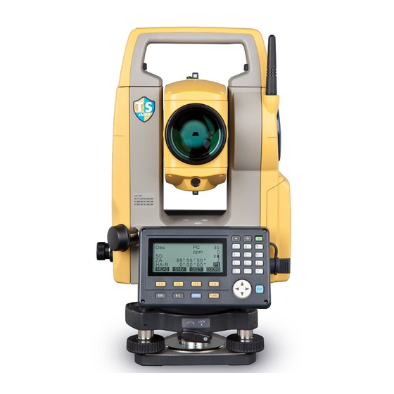
4.1 Parts of the Instrument
Identifies and labels all external parts of the ES series instrument for user reference.
4.2 Mode Diagram
Illustrates the instrument's operational modes and how to navigate between them.
4.3 Bluetooth Wireless Technology
Details Bluetooth functionality, potential interference, and usage precautions.
5. Basic Operation
5.1 Basic Key Operation
Explains fundamental operations like power on/off, backlight control, and target type switching.
5.3 Star Key Mode
Describes accessing the Star Key menu for quick measurement settings and program starts.
6. Using the Battery
6.1 Battery Charging
Provides step-by-step instructions and safety guidelines for charging the instrument's battery.
6.2 Installing/Removing the Battery
Details the procedure for correctly installing and removing the battery pack.
7. Setting Up the Instrument
7.1 Centering
Explains the process of centering the instrument precisely over the survey point.
7.2 Levelling
Describes the procedure for accurately leveling the instrument using foot screws and circular levels.
10. Connecting to External Devices
10.1 Necessary Settings for Bluetooth Communication
Details essential configurations for enabling Bluetooth communication.
10.2 Establishing a Connection Between the ES and Paired Bluetooth Device
Guides users through the process of pairing and connecting Bluetooth devices.
10.3 Measurement Using Bluetooth Communication
Explains how to perform measurements utilizing the Bluetooth connection.
10.4 Registering/Outputting Data Using Bluetooth Communication
Covers registering known points and outputting job data wirelessly.
10.5 Connecting via Communication Cable
Outlines the procedure for establishing a wired connection using a communication cable.
11. Angle Measurement
11.1 Measuring the Horizontal Angle Between Two Points (Horizontal Angle 0°)
Explains using the 0SET function to measure included angles between points.
11.2 Setting the Horizontal Angle to a Required Value (Horizontal Angle Hold)
Describes how to set, hold, and record specific horizontal angles.
11.3 Angle Measurement and Outputting the Data
Covers performing angle measurements and outputting the data to external devices.
12. Distance Measurement
12.1 Returned Signal Checking
Explains checking signal strength for accurate distance measurements, especially at longer ranges.
12.2 Distance and Angle Measurement
Details the process of performing simultaneous distance and angle measurements.
12.3 Recalling the Measured Data
Guides users on how to retrieve and view previously stored measurement data.
12.4 Distance Measurement and Outputting the Data
Covers distance measurement and subsequent data output to peripheral equipment.
12.5 Coordinate Measurement and Outputting the Data
Explains coordinate measurement and how to output this data.
12.6 REM Measurement
Details the Remote Elevation Measurement function for inaccessible points.
13. Setting Instrument Station
13.1 Entering Instrument Station Data and Azimuth Angle
Covers inputting station coordinates, height, and azimuth angle.
13.1.1 Setting Azimuth Angle from Backsight Coordinates
Explains calculating azimuth angles using backsight point coordinates.
13.2 Setting Instrument Station Coordinate with Resection Measurement
Describes determining station coordinates through resection measurements.
13.2.1 Observation Setting
Details the observation settings required prior to performing resection measurements.
13.2.2 Coordinate Resection Measurement
Explains calculating instrument station coordinates by observing known points.
13.2.3 RL Observation in Resection Measurement
Covers the specific procedures for RL observations within resection measurements.
13.2.4 Height Resection Measurement
Details the process of determining the instrument station's height via resection.
15. Setting-out Measurement
15.1 Coordinates Setting-out Measurement
Guides on setting out points based on input coordinates and calculated angles/distances.
15.2 Distance Setting-out Measurement
Explains setting out points using specified distance and angle from a reference.
15.3 REM Setting-out Measurement
Describes setting out points using the Remote Elevation Measurement function.
16. Setting-out Line
16.1 Defining Baseline
Explains the process of defining a baseline by inputting or observing two points.
16.2 Setting-out Line Point
Describes finding point coordinates by inputting length and offset from a defined baseline.
16.3 Setting-out Line Line
Explains measuring a point's position relative to a baseline and connected line.
17. Setting-out Arc
17.1 Defining an Arc
Details defining an arc using parameters like radius, angle, and coordinates.
17.2 Setting-out Arc
Explains finding coordinates of points along a defined arc using length and offset.
18. Point Projection
18.1 Defining Baseline
Explains defining a baseline for point projection.
18.2 Point Projection
Describes the process of projecting points onto a defined baseline.
19. Topography Observation
19.1 Observation Setting
Details setting observation parameters for topography.
19.2 Observation
Explains how to perform topography observation.
20. Offset Measurement
20.1 Single-distance Offset Measurement
Explains finding points by entering horizontal distance from the target.
20.2 Angle Offset Measurement
Describes finding points using included angle.
20.3 Two-distance Offset Measurement
Explains measuring points using two distances and a target.
20.4 Plane Offset Measurement
Details finding distance/coordinates on a plane where direct measurement is difficult.
20.5 Column Offset Measurement
Explains finding coordinates of a column's center.
21. Missing Line Measurement
21.1 Measuring the Distance Between 2 or More Points
Explains measuring distances between multiple points.
21.2 Changing the Starting Point
Describes how to change the starting point for missing line measurements.
25. Route Surveying
25.1 Instrument Station Settings
Explains setting the instrument station as a reference point.
25.2 Straight Line Calculation
Details calculating center and width peg coordinates for straight lines.
25.3 Circular Curve Calculation
Explains finding center and width peg coordinates for circular curves.
25.4 Spiral Curve
Describes calculating coordinates for spiral (clothoid) curves.
25.5 Parabola
Explains calculating coordinates for parabolic curves.
25.6 3 Point Calculation
Details finding cardinal points from 3 IP points and curve properties.
25.7 Intersection Angle/Azimuth Angle Calculation
Explains finding coordinates from intersection angle or azimuth.
25.8 Route Calculation
Describes finding center/width pegs for routes with curves.
25.8.1 Inputting IPs (Intersection Points)
Details inputting intersection points for route calculation.
25.8.4 Clearing Data
Explains how to clear route data.
25.8.5 Automatic Calculation of Cardinal Points
Describes automatic calculation of key points on curves.
25.8.8 Setting Parameters
Details setting parameters for automatic calculation of cardinal points.
28. Recording Data - TOPO Menu -
28.1 Recording Instrument Station Data
Explains how to store instrument station coordinates and related data.
28.3 Recording Angle Measurement Data
Details storing angle measurement data.
28.4 Recording Distance Measurement Data
Explains how to store distance measurement data.
28.5 Recording Coordinate Data
Describes how to store coordinate data.
28.6 Recording Distance and Coordinate Data
Explains storing both distance and coordinate data simultaneously.
28.7 Recording Notes
Details how to prepare and record notes data.
28.8 Reviewing JOB Data
Explains how to display and review data within the current JOB.
28.9 Deleting Recorded JOB Data
Describes how to delete recorded JOB data.
29. Selecting/Deleting a JOB
29.1 Selecting a JOB
Explains how to select the current JOB and coordinate search JOB.
29.2 Deleting a JOB
Details the procedure for deleting a JOB.
30. Registering/Deleting Data
30.1 Registering/Deleting Known Point Data
Covers registering or deleting known point coordinate data.
30.2 Reviewing Known Point Data
Explains how to display all coordinate data within the current JOB.
30.3 Registering/Deleting Codes
Describes saving and reading codes in memory.
30.4 Reviewing Codes
Explains how to review registered codes.
31. Outputting Job Data
31.1 Outputting JOB Data to Host Computer
Details how to output JOB data to a host computer.
32. Using USB Memory Device
32.1 Inserting the USB Memory Device
Provides instructions for inserting a USB memory device.
32.2 Selecting T type/S type
Explains how to select T type or S type for communication.
32.3 Storing JOB Data to USB Memory Device
Describes saving JOB data to a USB memory device.
32.5 Displaying and Editing Files
Covers displaying file information, editing names, and deleting files.
32.6 Formatting the Selected External Memory Media
Explains how to format the USB memory device.
33. Changing the Settings
33.1 Configuration -Config Mode-
Explains various configuration settings.
33.2 EDM Settings
Details settings related to the EDM (Electronic Distance Measurement).
33.3 Allocating Key Functions
Describes how to assign functions to softkeys.
33.4 Changing Password
Explains how to change the device password.
33.5 Restoring Default Settings
Covers restoring the instrument to its default settings.
35. Checks and Adjustments
35.1 Circular Level
Explains checking and adjusting the circular level.
35.2 Tilt Sensor
Describes checking and canceling tilt zero point errors.
35.3 Collimation
Explains measuring collimation error for angular observations.
35.4 Reticle
Details checking the reticle's perpendicularity to the horizontal axis.
35.5 Optical Plummet
Explains checking and adjusting the optical plummet.
35.6 Additive Distance Constant
Describes checking and adjusting the additive distance constant.
35.7 Laser Plummet
Explains checking and adjusting the laser plummet.
36. Standard Equipment and Optional Accessories
36.1 Standard Equipment
Lists standard accessories included with the instrument.
36.2 Optional Accessories
Lists optional accessories available for purchase.
36.3 Prism System
Illustrates arrangements of prism systems.
36.4 Power Supplies
Details available power supply combinations.
38. Explanation
38.1 Manually Indexing the Vertical Circle by Face Left, Face Right Measurement
Explains manually indexing the vertical circle for high precision angle measurements.
38.2 Correction for Refraction and Earth Curvature
Details distance calculation formulas accounting for refraction and earth curvature.
Need help?
Do you have a question about the ES-102 and is the answer not in the manual?
Questions and answers