Table of Contents
Advertisement
Quick Links
Advertisement
Table of Contents

Related Manuals for Topcon ES-65


Summarization of Contents
PRECAUTIONS FOR SAFE OPERATION
Definition of Indication
Explains the meaning of warning and caution symbols used in the manual.
Power Supply Safety
Safety guidelines related to the instrument's power supply and battery charger.
Tripod Safety
Safety measures when using the tripod with the instrument to prevent accidents.
Bluetooth Wireless Technology Safety
Safety guidelines for using the Bluetooth function, especially near medical equipment or aircraft.
PRECAUTIONS
Battery Charging Procedures
Instructions for correctly charging the instrument's battery to ensure optimal performance.
Tribrach Clamp Usage
How to use the tribrach clamp to secure the instrument to the tribrach.
Water and Dust Resistance
Information on maintaining the instrument's IP66 rating for water and dust resistance.
Battery Lifetime and Handling
Details on the expected lifespan of the lithium battery and proper handling.
Clamp Usage for Accuracy
Importance of fully releasing clamps for accurate instrument rotation.
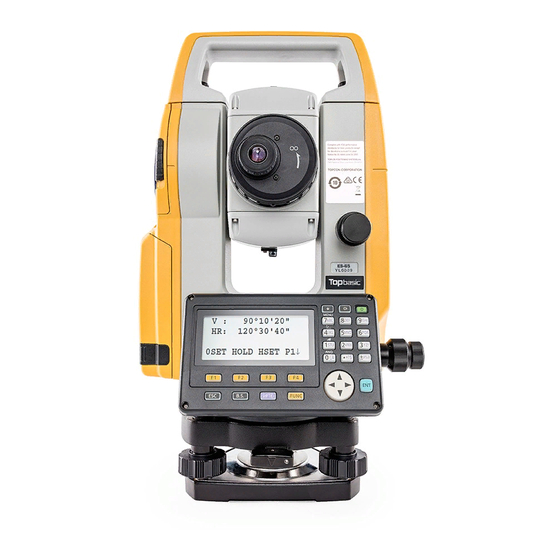
NOMENCLATURE AND FUNCTIONS
Instrument Components Overview
Identification and description of all parts and functions of the instrument.
Display and Key Functions
Explanation of the instrument's display screen, soft keys, and operating keys.
Star Key Mode Operations
How to access and use the star key for instrument options and settings.
PREPARATION FOR MEASUREMENT
Powering On and Initial Checks
Steps to turn on the instrument and perform initial checks before measurement.
Battery Status and Charging
Understanding the battery power display and its implications for operation.
Tilt Correction Setup
Configuring and understanding the automatic tilt correction for angles.
Entering Alphanumeric Data
Guide on inputting characters using the instrument's keypad.
Instrument Setup: Centering and Levelling
Procedures for mounting, centering, and leveling the instrument accurately.
Focusing and Target Sighting
Instructions for focusing the telescope and aligning the target for precise measurements.
ANGLE MEASUREMENT
Measuring Horizontal and Vertical Angles
Basic procedure for measuring horizontal and vertical angles to a target.
Setting and Holding Angles
Methods to set specific horizontal angles and measure from them.
Vertical Angle Percent Grade Mode
Displaying and measuring vertical angles as a percentage grade.
Repetition Angle Measurement
Performing multiple angle measurements for improved accuracy.
Buzzer Settings for Angle Increments
Configuring buzzer notifications for specific horizontal angle increments.
DISTANCE MEASUREMENT
Atmospheric and Prism Constant Settings
Setting atmospheric and prism constant corrections for accurate distance readings.
Continuous and N-Time Distance Measurement
Performing continuous or multiple-time distance measurements.
Measurement Modes: Fine, Tracking, Coarse
Selecting appropriate distance measurement modes for various applications.
Stake Out (S.O) Operation
Using the instrument to guide stake-out points based on input distances.
Offset Measurement Procedures
Performing measurements to points that cannot be sighted directly using offset techniques.
Angle Offset Measurement
Measuring coordinates of an offset point using angle measurements from a known position.
Distance Offset Measurement
Measuring coordinates of an offset point using a specified horizontal distance.
Plane Offset Measurement
Determining a plane and measuring points offset from it.
Column Offset Measurement
Measuring points on a column to determine its center.
COORDINATE MEASUREMENT
Setting Occupied Point Coordinates
Inputting the instrument's coordinates to establish the origin for measurements.
Setting Instrument and Target Heights
Inputting instrument and prism heights for accurate Z coordinate calculations.
Executing Coordinate Measurement
Performing measurements to determine the coordinates of unknown points.
SPECIAL MODE (Menu Mode)
Application Measurement Programs
Accessing various application measurement programs like REM, MLM, and Z COORD.
Grid Factor Settings
Configuring the grid factor for map projections and coordinate transformations.
Display and Reticle Illumination
Adjusting display contrast and reticle illumination settings.
Mode 1 Settings
Configuring basic instrument settings like minimum reading and auto power off.
Road Measurement Functions
Tools for inputting, searching, editing, and setting out road data.
DATA COLLECTION
Data Collection Preparation
Selecting files and setting occupied/backsight points before data collection.
Data Collection Procedures
Step-by-step instructions for collecting data, including PCODE input and searching.
Offset Measurement in Data Collect
Performing offset measurements within the data collection mode.
NEZ Auto Calculation
Automatic calculation and storage of N, E, Z coordinates during data collection.
Point to Line Measurement
Measuring offset points relative to a defined line during data collection.
LAYOUT
Layout Preparation
Steps to prepare for layout, including setting grid factor and selecting files.
Executing Layout Operations
Procedures for performing layout tasks, such as setting points and guiding stakeouts.
Setting New Points for Layout
Methods for establishing new points when existing points are not visible.
Side Shot Method for New Points
Measuring new points from a known instrument location.
Resection Method for New Points
Calculating the instrument's position by measuring known points.
MEMORY MANAGER MODE
Internal Memory Status
Checking the status of the instrument's internal memory and file counts.
Data Searching
Locating recorded data files using various search criteria.
File Maintenance Operations
Managing files by renaming, searching, or deleting them.
Coordinate Data Input
Directly inputting coordinate data using the keyboard for layout or control points.
Deleting Coordinate Data
Removing specific coordinate data entries from a file.
Editing PCODE Library
Managing the PCODE library by adding, editing, or deleting entries.
Data Communications
Transferring data between the instrument and a computer via RS-232C or USB.
Initialization of Internal Memory
Resetting the internal memory to its default state, erasing all stored data.
SETTING ATMOSPHERIC CORRECTION
Calculating Atmospheric Correction
Using formulas to calculate atmospheric correction factors based on environmental data.
Setting Atmospheric Correction Values
Directly inputting temperature and pressure to set atmospheric correction.
CORRECTION FOR REFRACTION AND EARTH CURVATURE
Distance Calculation Formula
Formulas used for distance calculations that include refraction and earth curvature.
POWER SOURCE AND CHARGING
Battery Charging Procedures
Guidelines and steps for safely charging the instrument's battery.
Installing and Removing the Battery
Correct procedures for inserting and removing the battery and adapter.
USING USB FLASH DRIVE
Inserting the USB Flash Drive
Steps for properly inserting a USB flash drive into the instrument's port.
DETACH/ATTACH OF TRIBRACH
Instrument Detachment from Tribrach
Steps to detach the instrument from the tribrach.
Instrument Attachment to Tribrach
Steps to attach the instrument securely to the tribrach.
SELECTING MODE
Available Selecting Modes
Overview of selectable modes for units, measurement, and other settings.
Setting Mode Parameters
Guide on how to configure various instrument modes and parameters.
CHECKS AND ADJUSTMENTS
Circular Level Check and Adjustment
Procedures for checking and adjusting the instrument's circular level.
Vertical Angle 0 Datum Adjustment
Adjusting the vertical angle zero point for accurate measurements.
Systematic Error Correction
Compensating for systematic errors in the instrument's measurement system.
Reticle Checks and Adjustments
Verifying and adjusting the reticle's perpendicularity and line positions.
Optical Plummet Check and Adjustment
Procedures for checking and adjusting the optical plummet.
Additive Distance Constant Check
Verifying the additive distance constant for measurement accuracy.
Laser Plummet Check and Adjustment
Procedures for checking and adjusting the laser plummet's alignment.
TOP FIELD MODE
Main Menu Overview
Introduction to the main functions available in the Top Field Mode.
Job Management
Creating, selecting, and deleting job files for organizing work.
Configuration Settings
Adjusting settings like distance units, coordinate format, and EDM mode.
Go To Work Operations
Steps for setting occupied points, performing layouts, and conducting measurements.
Setting Occupied Point and Backsight
Establishing the instrument's position and backsight reference for work.
Layout Execution
Guiding stakeout operations based on coordinate data.
Setting New Points for Layout
Methods for establishing new points when existing points are not visible.
Side Shot Method for New Points
Measuring new points from a known instrument location.
Resection Method for New Points
Calculating the instrument's position by measuring known points.
Data Manager Functions
Managing coordinate data by adding, deleting, viewing, editing, and transferring.
SPECIAL ACCESSORIES
Plumb Bob Usage
Using the plumb bob for centering the instrument.
Tubular Compass Functionality
Using the tubular compass to find magnetic north, with limitations.
Eyepiece Lenses
Optional eyepiece lenses for enhanced observation.
Solar Filter for Protection
Attaching a solar filter to protect the lens and operator during solar observations.
APPENDIX
Laser Plummet Adjustment Target
Diagrams of targets for adjusting the laser plummet.
Need help?
Do you have a question about the ES-65 and is the answer not in the manual?
Questions and answers