Table of Contents
Advertisement
Quick Links
Advertisement
Table of Contents

Related Manuals for Leica Geosystems BLK3D


Summary of Contents for Leica Geosystems BLK3D
- Page 1 Leica BLK3D User Manual Version 2.2 English...
- Page 2 Validity of this This manual applies to the Leica Geosystems AG BLK3D. manual Leica Geosystems On the last page of this manual, you can find the address of Leica Geosystems address book headquarters. For a list of regional contacts, please visit http://leica-geosystems.com/contact-us/sales_support.
-
Page 3: Table Of Contents
Publisher (Optional) Organiser Check & Adjust Care and Transport 17.1 Transport 17.2 Storage 17.3 Cleaning and Drying Technical Data 18.1 Conformity to National Regulations 18.1.1 BLK3D 18.1.2 Dangerous Goods Regulations 18.2 General Technical Data of the Product Warranty Table of Contents... - Page 4 Definition of Use 20.3 Limits of Use 20.4 Responsibilities 20.5 Hazards of Use 20.6 Laser Classification 20.6.1 General 20.6.2 BLK3D 20.7 Electromagnetic Compatibility (EMC) 20.8 FCC Statement, Applicable in U.S. 20.9 ISED Statements (EN/FR), Applicable in Canada Table of Contents...
-
Page 5: Instrument Components
Instrument Components Instrument compon- The Leica BLK3D Imager is a real-time, in picture 3D measurement solution. ents See chapter Technical Data for scope of use. Touch screen Laser/Photo capture Back Home Laser/Photo capture Recents Photo capture USB port protection lid... -
Page 6: Home Screen
Home Screen Home screen Status bar Side menu Reality Capture Sketch & Document (Optional) New Project Laser BIM 360 (Optional) Organiser Home Screen... -
Page 7: Batteries
For Li-Ion batteries, a single discharging and charging cycle is sufficient. • We recommend carrying out the process when the battery capacity indic- ated on the charger or on a Leica Geosystems product deviates signific- antly from the actual battery capacity available. Operation/discharging The batteries can be operated from −20 °C to +55 °C/−4 °F to +131 °F. -
Page 8: Charging The Battery By Usb Charger (Optional)
Remove the battery (d) from the charger (a). Place the battery (d), bottom first in the BLK3D. Make sure that the battery (d) and the plastic strip are in the correct ☞ position. Install the battery cover (e) top first on the BLK3D. Batteries... - Page 9 ☞ Make sure that the battery cover (e) and the slider (f) are in the cor- rect position. Batteries...
-
Page 10: Power Functions
Power Functions Switching ON/OFF Switching ON Press the ON/OFF button (a) to switch the device on. Switching OFF Press and hold the ON/OFF button (a) for at least two seconds to switch the device off. Power Functions... -
Page 11: Update
Update Update BLK3D searches for updates when starting the app. Update... -
Page 12: Using The Touchscreen
Using the touchscreen Using the touch It is recommended to use fingers on the touch screen. To avoid dam- ☞ screen age to the touch screen, do not apply excessive pressure or tap the touch screen with anything sharp. Do not allow the touch screen to come into contact with other elec- ☞... -
Page 13: Activation
Activation Activation Select a language for the operating system. Copy your data from another device or Set up as new. Activation... - Page 14 Connect to a Wi-Fi network. Protect your device with a PIN or a Password (optional). Activation...
-
Page 15: Settings
Settings Settings Select the Settings menu. Enter the user data. The entered data is stored in your projects and is automatically used ☞ to fill in the header of an exported PDF report. Settings... - Page 16 Select the measurement unit. Select the language. Settings...
-
Page 17: Measurement Principle
Reality Capture. This distance can be increased by using Multi-Shot from slightly different positions. The pictures from the two cameras are displayed on the BLK3D screen. Only points which are visible in both pictures can be measured. Measurement Principle... - Page 18 The intersection angle between the two lines of sight from the two cameras is key for good 3D accuracy. The angle is affected with the distance (D) to the object and the baseline length (B). To increase the accuracy, take the picture from a short dis- tance (D) to the object.
- Page 19 To increase the baseline length (B), take up to four shots from slightly different positions. Longer baseline (B) => Better results ☞ Measurement Principle...
- Page 20 Multi-Shot is required for 3D measurements and 3D Images which should be used for 3D modelling. To increase the accuracy, take up to four shots. Recommended The recommended baseline length between two shots is 10% of the distance baseline length from the imager to the object.
- Page 21 Multi-shot For 2D measurements with a distance of more than 2.5 m/8.2 ft and for all 3D measurements, use the Multi-Shot function. Take 2 shots for distances between 2.5 m/8.2 ft and 5.5 m/18.0 ft. • Take 3 shots for distances between 4.5 m/14.8 ft and 8.5 m/27.9 ft, and •...
-
Page 22: Reality Capture
Menu: Show menu for main navigation. • ☞ Hold the BLK3D correctly. Make sure that your fingers do not cover the cameras. Ensure that the object you want to measure is visible in all pictures. Only points which are visible in at least two pictures can be meas- ured. -
Page 23: Measure Distances In Picture
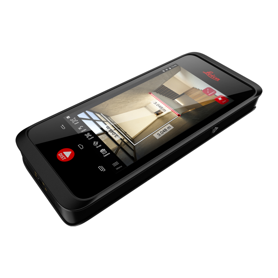
To increase measurement accuracy take another picture from a slightly different perspective. Review pictures. Press Remove to delete unwanted pictures and Done to exit Review mode. Go to Measure mode, (see Measure Distances in Picture). New: Capture the next Reality Capture 3D image without •... - Page 24 Tap on any measured point again to activate Precise mode. Drag and spread to precisely centre of the point you want to meas- ure in the crosshairs. Done: Confirm point position. • Next: Jump to the next point for Precise mode selection. •...
-
Page 25: Measure Areas In Picture
10.3 Measure Areas in Picture Measure areas in pic- Select Area, then zoom into the object you want to measure using ture gestures. Tap the first point on the picture to start the measuring process. Snap: Automatic snap to edges in picture (active by default). •... -
Page 26: Accuracy Feedback
Select Tools to add Tags, Rename or delete the 3D image (Delete Scene), move 3D image to a project (Move to Project), (see Organ- iser) and measure distances with laser (Laser measurement), (see Laser). Select a line and measure the distance with the laser to crosscheck the distance. -
Page 27: Laser
Laser 11.1 Distance Distance Select the Laser function. 20013_001 Adjust the measuring reference (base): Back: Distance is measured from the bottom of the device • (default setting). Front: Distance is measured from the top of the device. • Corner adaptor: Distance is measured from the Corner adaptor •... -
Page 28: Smart Horizontal
Select Tools to choose between different measurements (Distance, Smart Horizontal, Area and Volume) and export measurement into a PDF report. Select Export and select the measurement to be printed in a PDF report. Swipe right to left to delete a single measurement, or select Clear to delete all measurements from the measurement list. -
Page 29: Tracking
Vertical and horizontal distances are calculated. 11.3 Tracking Tracking Press the Laser button for two seconds to activate Tracking mode. Press the Laser button again to finish the measurement. 11.4 Area Area Select Area from Tools. Adjust measure reference if needed. ☞... -
Page 30: Volume
Circumference and area are automatically calculated. 11.5 Volume Volume Select Volume from Tools. Adjust measure reference if needed. ☞ Measure three distances (length, width and height) with the Laser button. Area, wall area, circumference and volume are automatically calcu- lated. Laser... -
Page 31: Sketch & Document (Optional)
Sketch & Document (Optional) 12.1 Import Plan (Optional) Import Plan (optional) Select the Import Plan function from the Sketch & Document menu. Select one of the following options: Camera: Take a picture with the device camera. • Gallery: Import an image from the picture gallery. •... - Page 32 Use the Rotate function to change the orientation of the image. Tap Done to confirm. Document mode is automatically enabled. Tap Place and then tap the screen to insert a new place. ☞ To add 3D images to the place, select the place (see Sketch Plan (Optional)).
- Page 33 Switch to Sketch mode. Tap Line and draw by dragging or tapping. Tap Line again to finish the line. ☞ The line finishes automatically when connecting it to the start point. Tap Area and draw by dragging or tapping. To create an area, tap at least three points on the screen.
-
Page 34: Sketch Plan (Optional)
Select a line and press Laser to measure the length. Alternatively select a line and press Enter to add length. 12.2 Sketch Plan (Optional) Sketch Plan (optional) Select the Sketch Plan function from the Sketch & Document menu. 20048_001 Select Line button and draw by dragging or tapping. Press again the button to finish the line. - Page 35 Select a line and press Laser to measure the length. The sketch is automatically scaled. Calculated values are in brackets. Area and circumference are automatically printed on sketch. Alternatively select a line and press Enter to add length. Select a line and press Opening to add doors or windows. Drag the opening to move it or select the distance from the wall and measure it.
- Page 36 Switch to 3D mode. A room height can be entered. ☞ Switch to Document. A place is automatically assigned to each line. Drag a place to move it. Press the Place button and tap the screen to add a new place. Select an empty place to add a 3D image.
-
Page 37: Smart Room (Optional)
To delete a place, press it for 2 seconds and press Delete. All the stored 3D images are deleted. 12.3 Smart Room (Optional) Smart Room Select the Smart Room function from the Sketch & Document (optional) menu. 20068_001 Adjust measuring reference: Back: Distance is measured from the bottom of the device •... -
Page 38: Measure Plan (Optional)
All measured values are displayed. After the last measurement press Finish. The floorplan can be modified in Sketch mode, (see Sketch Plan (Optional)). 12.4 Measure Plan (Optional) Measure Plan Connect the BLK3D to the Leica DST 360 adapter. (optional) Sketch & Document (Optional) - Page 39 Select the Measure Plan function from the Sketch & Document menu. 20087_001 Level the instrument before starting to measure. Follow the on screen instructions. Select Point, Line or Area in the P2P Measure Tab. Point the laser at the target and measure with the Measure button. Measured points are projected onto the floorplan and are automat- ically shown on screen.
-
Page 40: Measure Facade (Optional)
Sketch Plan (Optional)) or visualised in 3D. 12.5 Measure Facade (Optional) Measure Facade Connect the BLK3D to the Leica DST 360 adapter. (optional) Select the Measure Facade function from the Sketch & Docu- ment menu. 20093_001 Level the instrument before starting to measure. Follow the on screen instructions. - Page 41 After the facade plan has been defined, select Point, Line or Area in the P2P Measure Tab. Point the laser at the target and measure with the Measure button. Measured points are projected onto the floorplan and are automat- ically shown on screen. Activate Pointfinder to use the front camera to find the target point and measure with the Measure button.
-
Page 42: Bim 360 (Optional)
BIM 360 (Optional) BIM 360 (optional) Overview Autodesk BIM 360 Docs integration with BLK3D, allows the sharing of 3D images into the BIM 360 environment. 3D images captured with the BLK3D can be stored in Autodesk BIM ☞ 360 issues. - Page 43 Make sure that your Autodesk account is activated in ☞ Autodesk BIM 360 Docs. All the BIM 360 data is automatically synced to the BLK3D after sign-in. The icon in the top toolbar indicates the status of the syncing progress: - Syncing in progress.
- Page 44 Each file has a sync Status icon: - Syncing in progress. • - Syncing successful. • - Syncing failed. • - Syncing not started. • Tap a file to open it. Tap Add to create a new issue. Tap on the screen to place the issue.
- Page 45 Enter the New Issue, Title and Description. • Set issue Status to Open or Draft. • Tap New to capture a new 3D image and add it to the • issue. Alternatively, tap Browse and select a 3D image, then •...
-
Page 46: Publisher (Optional)
Publishing a link uploads the 3D Image to the cloud where it is accessible for 90 days. A link is automatically created. To select an app for sharing the link, tap Share. This link can be used to open the 3D Image in BLK3D Web. Publisher (Optional) - Page 47 To attach the published link to an email, tap the Share button. You can also delete a link, or enable or disable write access. When a link is deleted, the 3D Image is removed from the cloud and ☞ cannot be opened anymore on BLK3D Web. Publisher (Optional)
-
Page 48: Organiser
Organiser Organiser Select the Organiser function. 20076_001 All the plans and 3D images are stored in five categories: All. Projects. 3D Images. Plans. Exports. Open the category All. All the plans, 3D images and projects are stored. ☞ Use the Select option to select an item. Different actions are avail- able: Export, Move, Rename, Tag and Delete. - Page 49 Open the category 3D Images. Press the RC button to switch to Reality Capture to take new 3D images. ☞ All the Reality Capture 3D images are stored. Open the category Plans. All plans, including plans with attached 3D images, are stored. ☞...
-
Page 50: Check & Adjust
Check & Adjust Check & adjust The check and adjustment of the BLK3D is possible thanks to the Check & Adjust function. Check - Is the process of verifying the accuracy of the device with the Initial Accuracy Test. Can be done hand-held. - Page 51 The check failed. Device is not calibrated. Select Calibrate to start adjustment process. Select Later to postpone. To perform the adjustment Mount the BLK3D horizontally on the tripod. Adjustment is not possible without the tripod. ☞ Place or hang the calibration plate on the wall.
- Page 52 The adjustment process is done in the following steps: Adjust the distance of the camera from the calibration target. Move left or right following the on screen instructions. Fit the calibration target into the red frame shown on screen. Trigger the picture using the on screen Laser/Photo cap- ture option.
-
Page 53: Care And Transport
Never immerse the device in water. • Never use aggressive cleaning agents or solvents. • Back up your data regularly. Leica Geosystems AG is not liable for data • loss. BLK3D Imager is a highly accurate optical measurement device. •... -
Page 54: Cleaning And Drying
17.3 Cleaning and Drying Product and accessor- Blow dust off lenses and prisms. • Never touch the glass with your fingers. • Use only a clean, soft, lint-free cloth for cleaning. If necessary, moisten • the cloth with water or pure alcohol. Do not use other liquids; these may attack the polymer components. -
Page 55: Technical Data
18.1 Conformity to National Regulations Regulatory informa- Regulatory information, certification, and compliance marks are available on tion the BLK3D. Go to Android Settings > About phone > Regulatory labels. 18.1.1 BLK3D Conformity to FCC Part 15 (applicable in US) •... - Page 56 Type Value Accuracy with unfavourable condi- ±2.0 mm ±0.08 in tions 250 m 820 ft Range with favourable conditions 120 m 394 ft Range with unfavourable conditions Smallest unit displayed 0.1 mm 1/32 in X-Range Power Technology Ø laser point at distances 6 mm at 10 m 30 mm at 50 m 60 mm at 100 m...
- Page 57 Type Value Storage −25 to 60°C −13 to 140°F Operation −10 to 50°C 14 to 122°F Charging 0 to 40°C 32 to 104°F Tripod adapter Supports 1/4-20 UNC screw adapters Technology Type Value Operating System Android 7 (Nougat) Processor Snapdragon 820E QuadCore (2.35 GHz) RAM memory 4 GB...
- Page 58 Type Value Bluetooth v4.1 and v2.1 Radiated power (BLE) 1.78 mW Radiated power (BT classic) 10.00 mW Frequency 2402 - 2480 MHz Type Value WLAN Standard 802.11 b/g/n Radiated power 6.31 mW Frequency 2412 - 2462 MHz A-GPS and GLONASS Power management Type Value...
-
Page 59: Warranty
Warranty Description The Leica BLK3D comes with a one year warranty from Leica Geosystems AG. More detailed information about the International Limited Warranty can be found on the internet at: https://leica-geosystems.com/-/media/files/leicageosystems/about_us/legal %20document/internationallimitedwarranty_english_2013.ashx?la=en Warranty... -
Page 60: Safety Directions
Safety Directions 20.1 General Description The following directions enable the person responsible for the product, and the person who actually uses the equipment, to anticipate and avoid opera- tional hazards. The person responsible for the product must ensure that all users understand these directions and adhere to them. -
Page 61: Definition Of Use
Use of products with recognisable damage or defects • Use with accessories from other manufacturers without the prior explicit • approval of Leica Geosystems Deliberate dazzling of third parties • Controlling of machines, moving objects or similar monitoring application •... -
Page 62: Responsibilities
User Manual, particularly after the product has been subjected to abnormal use as well as before and after important measurements. ☞ We recommend using the Check & Adjust function with the BLK3D calibration target plate to check the accuracy. WARNING Inappropriate mechanical influences to batteries During the transport, shipping or disposal of batteries it is possible for inap- propriate mechanical influences to constitute a fire hazard. - Page 63 Always prevent access to the product by unauthorised personnel. WARNING Improperly repaired equipment Risk of injuries to users and equipment destruction due to lack of repair knowledge. Precautions: ▶ Only authorised Leica Geosystems Service Centres are entitled to repair these products. Safety Directions...
-
Page 64: Laser Classification
CAUTION Changes or modifications not expressly approved by Leica Geosystems for compliance could void the user's authority to operate the equipment. CAUTION Only use chargers recommended by the manufacturer to charge the batteries. 20.6 Laser Classification 20.6.1 General General The following chapters provide instructions and training information about laser safety according to international standard IEC 60825-1 (2014-05) and technical report IEC TR 60825-14 (2004-02). -
Page 65: Electromagnetic Compatibility (Emc)
Electromagnetic radiation can cause disturbances in other equipment. Precautions: ▶ Although the product meets the strict regulations and standards which are in force in this respect, Leica Geosystems cannot completely exclude the possibility that other equipment may be disturbed. Safety Directions... -
Page 66: Fcc Statement, Applicable In U
Although the product meets the strict regulations and standards which are in force in this respect, Leica Geosystems cannot completely exclude the possib- ility that function of the product may be disturbed in such an electromagnetic environment. - Page 67 CAUTION Changes or modifications not expressly approved by Leica Geosystems for compliance could void the user's authority to operate the equipment. FCC Radiation Expos- The radiated output power of the instrument is far below the FCC radio fre- ure Statement quency exposure limits.
-
Page 68: Ised Statements (En/Fr), Applicable In Canada
20.9 ISED Statements (EN/FR), Applicable in Canada WARNING This Class (B) digital apparatus complies with Canadian ICES-003. Cet appareil numérique de la classe (B) est conforme à la norme NMB-003 du Canada. Canada Compliance Statement This device contains licence-exempt transmitter(s)/receiver(s) that comply with Innovation, Science and Economic Development Canada’s licence- exempt RSS(s). - Page 70 905446-2.2.0en Original text Published in Switzerland © 2020 Leica Geosystems AG, Heerbrugg, Switzerland Leica Geosystems AG Heinrich-Wild-Strasse CH-9435 Heerbrugg Switzerland Phone +41 71 727 31 31 www.leica-geosystems.com...
Need help?
Do you have a question about the BLK3D and is the answer not in the manual?
Questions and answers