Lowrance LMS-522c iGPS Manuals
Manuals and User Guides for Lowrance LMS-522c iGPS. We have 2 Lowrance LMS-522c iGPS manuals available for free PDF download: Installation And Operation Instructions Manual
Lowrance LMS-522c iGPS Installation And Operation Instructions Manual (252 pages)
Fish-finding Sonar & Mapping GPS
Table of Contents
-
-
-
-
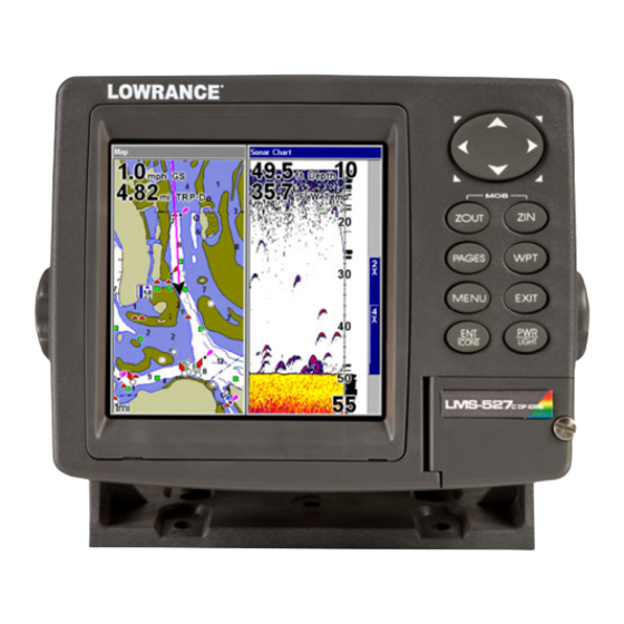
Face Cover51
-
Keyboard53
-
Main Menu54
-
Map Page57
-
Sonar Page58
-
-
-
Alarms68
-
Depth Alarms68
-
Zone Alarm69
-
Fish Alarm70
-
GPS Alarms71
-
-
Chart Speed74
-
Colorline75
-
Depth Cursor76
-
Fastrack79
-
Fishtrack82
-
Hyperscroll83
-
Overlay Data85
-
Sonar Simulator101
-
Stop Chart103
-
Surface Clarity104
-
Transparency105
-
Zoom & Zoom Bar106
-
Zoom Pan106
-
-
-
Keyboard111
-
-
-
Main Menu112
-
Sonar Page114
-
Navigation Page116
-
Map Page119
-
Map with Sonar123
-
-
Radar125
-
-
-
Searching129
-
Set a Waypoint131
-
Visual Trailing139
-
Icons146
-
Routes147
-
Trails153
-
Delete a Trail153
-
-
Utilities155
-
Alarm Clock155
-
Trip Calculator155
-
Trip down Timer155
-
Trip up Timer155
-
-
Waypoints155
-
Alarms159
-
-
Configure NMEA162
-
Map Fix164
-
GPS Simulator166
-
Hide GPS Feature168
-
Initialize GPS168
-
Map Auto Zoom169
-
Map Data169
-
Map Orientation172
-
Overlay Data180
-
Pop-Up Help184
-
Reset Options185
-
Set Language187
-
Set Local Time187
-
Show WAAS Alarm188
-
Track Smoothing191
-
Trail Options191
-
Transparency194
-
Units of Measure195
-
-
Bus Setup214
-
-
Tank Location218
-
Fuel Added218
-
Add Fuel219
-
Fill Tank219
-
-
Engine Select219
-
-
-
NMEA 2000 Alarms220
-
Waypoint Sharing221
-
-
-
Instance223
-
Restore Defaults223
-
-
-
Instance224
-
Restore Defaults224
-
-
-
Instance227
-
Restore Defaults227
-
-
-
Instance229
-
Restore Defaults229
-
Advertisement
Lowrance LMS-522c iGPS Installation And Operation Instructions Manual (252 pages)
Fish-finding Sonar & Mapping GPS
Table of Contents
-
-
-
-
Face Cover51
-
Keyboard53
-
Main Menu54
-
Map Page57
-
Sonar Page58
-
-
-
Alarms68
-
Depth Alarms68
-
Zone Alarm69
-
Fish Alarm70
-
GPS Alarms71
-
-
Chart Speed74
-
Colorline75
-
Depth Cursor76
-
Fastrack79
-
Fishtrack82
-
Hyperscroll83
-
Overlay Data85
-
Sonar Simulator101
-
Stop Chart103
-
Surface Clarity104
-
Transparency105
-
Zoom & Zoom Bar106
-
Zoom Pan106
-
-
-
Keyboard111
-
-
-
Main Menu112
-
Sonar Page114
-
Navigation Page116
-
Map Page119
-
Map with Sonar123
-
-
Radar125
-
-
-
Searching129
-
Set a Waypoint131
-
Visual Trailing139
-
Icons146
-
Routes147
-
Trails153
-
Delete a Trail153
-
-
Utilities155
-
Alarm Clock155
-
Trip Calculator155
-
Trip down Timer155
-
Trip up Timer155
-
-
Waypoints155
-
Alarms159
-
-
Configure NMEA162
-
Map Fix164
-
GPS Simulator166
-
Hide GPS Feature168
-
Initialize GPS168
-
Map Auto Zoom169
-
Map Data169
-
Map Orientation172
-
Overlay Data180
-
Pop-Up Help184
-
Reset Options185
-
Set Language187
-
Set Local Time187
-
Show WAAS Alarm188
-
Track Smoothing191
-
Trail Options191
-
Transparency194
-
Units of Measure195
-
-
Bus Setup214
-
-
Tank Location218
-
Fuel Added218
-
Add Fuel219
-
Fill Tank219
-
-
Engine Select219
-
-
-
NMEA 2000 Alarms220
-
Waypoint Sharing221
-
-
-
Instance223
-
Restore Defaults223
-
-
-
Instance224
-
Restore Defaults224
-
-
-
Instance227
-
Restore Defaults227
-
-
-
Instance229
-
Restore Defaults229
-
Advertisement