Sign In
Upload
Manuals
Brands
Lowrance Manuals
GPS
LMS-480
Lowrance LMS-480 Manuals
Manuals and User Guides for Lowrance LMS-480. We have
2
Lowrance LMS-480 manuals available for free PDF download: Operation Instructions Manual, Connection Manual
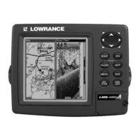
Lowrance LMS-480 Operation Instructions Manual (216 pages)
Fish-finding Sonar & Mapping GPS
Brand:
Lowrance
| Category:
Marine Equipment
| Size: 5.4 MB
Table of Contents
Operation Instructions
1
Visit Our Web Site
2
Table of Contents
3
Sec. 1: Read Me First
9
Capabilities and Specifications: LMS-480 and LMS-480DF
11
How LMS-480 Sonar Works
13
How LMS-480 GPS Works
14
Introduction to GPS and WAAS
16
How to Use this Manual: Typographical Conventions
18
Sec. 2: Installation & Accessories
21
Preparations
21
Transducer Installation
21
Selecting a Transducer Location
22
How Low Should You Go
23
Shoot-Thru-Hull Vs. Transom Mounting
24
Transom Transducer Assembly and Mounting
25
Trolling Motor Bracket Installation
31
Transducer Orientation and Fish Arches
31
Shoot-Thru-Hull Preparation and Installation
32
Speed/Temperature Sensors
36
GPS Antenna/Receiver Module
38
Power Connections
39
Powering a NMEA-2000 Buss
39
Powering Your Unit
40
NMEA 0183/DGPS Cable Connections
42
NMEA/DGPS Wiring
42
Mounting the Unit: Bracket, In-Dash or Portable
44
MMC or SD Card Memory Card Installation
47
Other Accessories
49
Face Cover
50
Sec. 3: Basic Sonar Operation
51
Keyboard
51
Power/Lights (Turn Unit on and Off)
52
Main Menu
52
Satellite Status Page
54
Navigation Page
55
Map Page
55
Sonar Page
56
Basic Sonar Quick Reference
59
Sonar Operations
60
Sec. 4: Sonar Options & Other Features
65
ASP (Advanced Signal Processing)
65
Alarms
66
Depth Alarms
66
Zone Alarm
67
Fish Alarm
68
Calibrate Speed
69
Chart Speed
70
Depth Cursor
70
Depth Range - Automatic
71
Depth Range - Manual
72
Depth Range - Upper and Lower Limits
73
Fastrack
74
Fish I.D. (Fish Symbols & Depths)
75
Fishtrack
76
Fishreveal
77
Frequency (Change Transducer Frequency)
79
Grayline
80
Hyperscroll
82
Log Sonar Chart Data
82
Noise Rejection
83
Overlay Data
83
Change Displayed Data Font Size
84
Ping Speed & Hyperscroll
85
Reset Options
87
Reset Water Distance
87
Set Keel Offset
87
Sensitivity & Auto Sensitivity
89
Turn Auto Sensitivity Back on
90
Sonar Color Mode
90
Sonar Page & Sonar Chart Display Options
91
Full Sonar Chart
91
Split Zoom Sonar Chart
92
Split Frequency Sonar Chart (LMS-480DF Only)
92
Digital Data/Chart
93
Flashgraf
95
Map with Sonar Split Screen
96
Sonar Simulator
96
Stop Chart
98
Surface Clarity
99
Upper and Lower Limits
100
Zoom & Zoom Bar
100
Zoom Pan
101
Sec. 5: Sonar Troubleshooting
103
Sec. 6: Basic GPS Operations
107
Keyboard
107
Power/Lights (Turn Unit on and Off)
108
Main Menu
108
Sonar Page
110
Satellite Status Page
110
Navigation Page
112
Map Page
114
Background Map Vs. Mapcreate Map Content
116
Basic GPS Quick Reference
120
Find Your Current Position
121
Moving Around the Map: Zoom & Cursor Arrow Keys
121
Selecting any Map Item with the Cursor
122
Searching
122
Set a Waypoint
124
Create Waypoint at Current Position
125
Create Waypoint on Map
126
Create Waypoint by Entering a Position
126
Navigate to a Waypoint
126
Set man Overboard (MOB) Waypoint
127
Navigate Back to MOB Waypoint
127
Navigate to Cursor Position on Map
128
Navigate to a Point of Interest
129
Creating and Saving a Trail
130
Displaying a Saved Trail
132
Navigating Trails
132
Visual Trailing
133
Navigate a Trail (Forward)
133
Navigate a Back Trail (Backtrack, or Reverse)
135
Transfer Custom Maps and GPS Data Files
136
Cancel Navigation
138
Sec. 7: Advanced GPS Operations
139
Find Distance from Current Position to Another Location
139
Find Distance from Point to Point
139
Icons
140
Create Icon on Map
140
Create Icon at Current Position
140
Delete an Icon
140
Navigate to an Icon
141
Routes
141
Create and Save a Route
142
Delete a Route
145
Edit a Route Name
145
Edit Route Waypoints
145
Navigate a Route
146
Navigate a Route in Reverse
147
Trails
148
Delete a Trail
148
Edit a Trail Name
148
Edit a Trail Color
148
Edit a Trail Pattern
149
Utilities
149
Alarm Clock
149
Sun/Moon Rise & Set Calculator
149
Trip Calculator
149
Trip down Timer
149
Trip up Timer
149
Waypoints
150
Delete a Waypoint
150
Edit a Waypoint (Name, Symbol and Position)
150
Selecting a Waypoint
151
Set a Waypoint by Average Position
151
Set a Waypoint by Projecting a Position
151
Sec. 8: System & GPS Setup Options
153
Alarms
153
Auto Satellite Search
154
Check MMC Files and Storage Space
155
Communications Port Configuration
155
Configure DGPS
156
Configure NMEA
157
Coordinate System Selection
157
Setup Loran TD
159
Map Fix
159
Customize Page Displays
160
DGPS Status
161
GPS Simulator
161
Simulating Trail or Route Navigation
162
Initialize GPS
163
Map Auto Zoom
163
Hide GPS Features
163
Map Boundaries
164
Pop-Up Map Information
164
Show Map Data
164
Map Data
164
Fill Water with White
165
Map Overlays (Range Rings; Lat/Long Grid)
165
Map Datum Selection
165
Map Detail Category Selection
166
Map Orientation
166
Navionics Charts
168
Display a Navionics Chart
168
Port Information
169
Tidal Current Information
170
Tide Information
171
Pop-Up Help
173
Position Pinning
173
Reset Options
174
Require DGPS
174
Screen Contrast and Brightness
175
Set Language
176
Set Local Time
176
Show WAAS Alarm
177
Software Version Information
177
Sounds and Alarm Sound Styles
178
Track Smoothing
178
Trail Options
179
Delete All Trails
179
Flash Trails on Screen Option
179
Update Trail Option
180
Update Trail Criteria (Auto, Time, Distance)
180
Trail Update Rate (Time, Distance)
180
Delete Trail
181
New Trail
181
Trail Visible/Invisible and Other Trail Options
181
Units of Measure
181
Sec. 9: Searching
183
Find Addresses
183
Find any Item Selected by Map Cursor
186
Find Interstate Highway Exits
187
Find Map Places or Points of Interest (POI)
189
Find Streets or Intersections
191
Find Waypoints
195
Sec. 10: Supplemental Material
199
Fcc Compliance
203
Index
205
How to Obtain Service
214
Advertisement
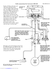
Lowrance LMS-480 Connection Manual (1 page)
Lowrance LMS-480: Connection Guide
Brand:
Lowrance
| Category:
GPS
| Size: 0.04 MB
Advertisement
Related Products
Lowrance LMS-480DF
Lowrance LMS-480M
Lowrance LMS 330C
Lowrance LMS-332C
Lowrance LMS-350A
Lowrance LMS-339cDF iGPS
Lowrance LMS-525C DF
Lowrance LMS-527cDF iGPS
Lowrance LMS 335C DF
Lowrance LMS-337C DF
Lowrance Categories
GPS
Sonar
Fish Finder
Marine Equipment
Accessories
More Lowrance Manuals
Login
Sign In
OR
Sign in with Facebook
Sign in with Google
Upload manual
Upload from disk
Upload from URL