Table of Contents
Advertisement
Advertisement
Table of Contents

Related Manuals for Magellan Magellan GPS 310


Summary of Contents for Magellan Magellan GPS 310
- Page 1 User Manual...
- Page 2 WARNINGS A measure of knowledge by the user is required for proper and safe use of the Magellan GPS 310™. READ THE USER MANUAL & WARRANTY COMPLETELY. Use Good Judgment This product is an excellent navigation aid, but it does not replace the need for careful orientation and good judgment.
-
Page 3: Table Of Contents
TABLE OF CONTENTS Introduction ... 1 Welcome to the Magellan GPS 310 ... 1 GPS 310 Description ... 1 Magellan GPS 310 Key Functions ... 2 Getting Started ... 3 Installing the Batteries ... 3 Getting Signals from Satellites ... 3 Initializing the Receiver - EZStart ... - Page 4 Setting Display Contrast ... 31 Using the Trip Odometer ... 31 Connecting to External Devices ... 32 NMEA Data Messages ... 34 Troubleshooting ... 41 Frequently Asked Questions ... 42 Icons ... 44 Contacting Magellan ... 45 GPS 310 TOC 10/18/99, 9:27 AM...
- Page 5 Accessories ... 46 Attaching the Wrist Lanyard ... 47 Shipping/Transporting ... 48 Glossary ... 49 Index ... 52 GPS 310 TOC 10/18/99, 9:27 AM...
- Page 6 GPS 310 TOC 10/18/99, 9:27 AM...
-
Page 7: Introduction
Introduction Welcome to the Magellan GPS 310 Congratulations on your purchase of the Magellan GPS 310 satellite navigator. The GPS 310 is an easy-to-use GPS receiver designed to get you out in the “Great Outdoors” rather than spending hours reading a User’s Manual. There... -
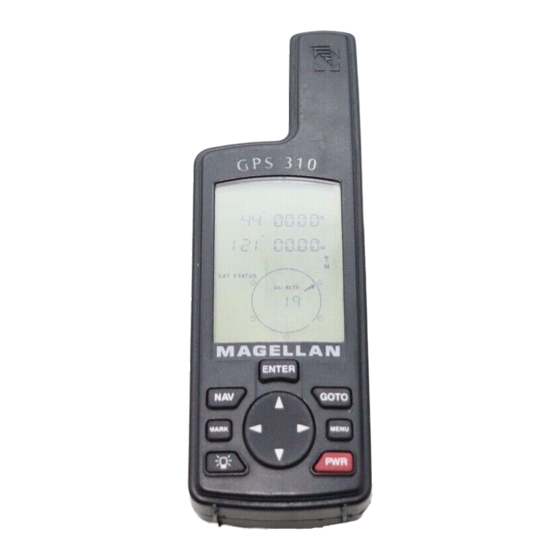
Page 8: Magellan Gps 310 Key Functions
Magellan GPS 310 Key Functions The ENTER key confirms data entries or menu selections. The NAV key accesses the Position and ENTER Navigation GOTO screens. MARK MENU The MARK key is used to create landmarks and store the current position. -
Page 9: Getting Started
Getting Started Installing the Batteries The GPS 310 uses two AA alkaline batteries that are installed at the back of the receiver. To remove the battery cover, turn the ring of the battery door screw counterclockwise until the battery cover can be removed. Insert the new batteries as shown, being sure to respect the polarities, and replace the... -
Page 10: Initializing The Receiver - Ezstart
Initializing the Receiver - EZStart Before using your GPS 310 for the first time, the receiver needs to know its approximate location. Using Magellan’s EZStart procedure, the GPS 310 will prompt you for the information it requires when you turn it on for the first time. -
Page 11: Computing A Position
ENTER ELEVATION. Use the ARROW pad to enter the approximate elevation for your position. If unknown, leave the elevation at 0. Press ENTER TIME. Use the ARROW pad to enter your present time. Press ENTER ENTER DATE. Use the ARROW pad to enter the date. Press ENTER The GPS 310 then displays the POSITION screen and... - Page 12 The number at the bottom right of the screen displays how many satellites are being tracked. After the GPS receiver has received positioning data from at least three satellites (approximately 2-3 minutes), it will begin computing a position fix based upon the information it is receiving.
-
Page 13: Basic Operation
Basic Operation Saving a Position Fix Position fixes can be saved in memory for use later when you want to return to that position. Saved position fixes are referred to as landmarks or LMK. To save (mark) your current position press Receiver-Generated Name: The GPS 310 prompts you to enter a name or accept the receiver-generated name for this landmark. -
Page 14: Creating A Landmark
Creating a Landmark To create a landmark at a location which is not your current position, use the same procedure as saving a position with the additional step of inputting different latitude/longitude coordinates. To create a landmark press MARK The GPS 310 prompts you to enter a name or accept the receiver- generated name for this landmark. -
Page 15: Viewing The Position Screen
Viewing the POSITION Screen The POSITION screen displays the coordinates for your last computed position and information about any satellites that are visible. It can be accessed by pressing the Latitude and Longitude Satellite Elevation Degrees above the horizon of the satellite indicated by the satellite pointer. -
Page 16: Viewing The Navigation Screens
Viewing the Navigation Screens Without an Active Route. Without an active route the navigation screen displays your heading and the speed at which you are traveling. The lower portion of the screen displays a moving compass. The triangle at the top of the compass points in the direction you are traveling and the arrow points to north. - Page 17 With an Active Route. When you have an active route the navigation screen still displays your heading and speed but also includes the bearing and distance to your destination. The moving compass is then replaced with steering informa- tion. You can use the graphical representation or the steering indicator to assist in directing you towards your final destina- tion.
- Page 18 A second navigational screen is also provided while you have an active route. This screen is very similar to the first screen except that the distance to the destination has been replaced with XTE (cross track error, the distance left or right that you are off course) and heading has been replaced with TTG (time to go).
-
Page 19: Creating A Goto Route
Creating a GOTO Route The simplest form of a route is a one-leg route called a GOTO route (you are GOing TO a destination). This is routing you from your current position to a landmark stored in memory All that is required to create a GOTO route is that you have saved a landmark indicating the location of your destination. -
Page 20: Summary
If the receiver is not tracking sufficient satellites to compute a position fix, the start of the newly created GOTO route will be the last position computed, which may not be the current position. This GOTO route will remain the active route until a new GOTO route is created, a multileg route is activated, or the receiver is turned off. -
Page 21: Working With Landmarks
Working with Landmarks Viewing a Landmark To view a stored landmark press until LMKS appears at the top of the screen. Press . The BEARING/DIS- ENTER TANCE screen for the first landmark in the receiver’s memory is displayed with the bearing and distance from the last computed position fix to that landmark. -
Page 22: Editing A Landmark
Editing a Landmark Following the instructions under Viewing a Landmark, use the LEFT/RIGHT arrows to select the landmark you wish to edit. Press the UP ARROW until the screen displays PRESS ENT TO EDIT, then press ENTER You can modify the landmark name and/or the coordinates for the landmark by using the UP/DOWN arrows to change the information and press to move to the next line. -
Page 23: Working With Routes
Working with Routes The route function allows you to link a series of landmarks and travel, point by point, to a final destination. The route depicted here is a three-leg route. Leg 1 extends from landmark A to landmark B, leg 2 from landmark B to landmark C, and leg 3 from C to D. - Page 24 The receiver prompts you for a starting landmark for the route. The first landmark, *POS, is your present position. Use the ARROW pad to scroll through the list of landmarks. When the desired landmark is displayed (and flashing) press ENTER The display changes to allow the selection of the landmark to be used as the end of the first leg in the route.
-
Page 25: Viewing A Route
pad to select a landmark as the destination for this leg or press to signal the GPS 310 that this was the last leg in the ENTER route and you are finished creating a route. Continue this process for each leg in the route remembering to press with END ROUTE displayed in the TO ENTER... -
Page 26: Activating/Deactivating A Route
The first screen displayed is the ROUTE SUMMARY screen. This screen displays the start and end landmark for the entire route as well as the total distance of the route. Use the LEFT/RIGHT ARROWs to view the legs in the route. The leg screen displays the FROM and TO landmark for the leg as well as the distance and bearing for the leg. -
Page 27: Deleting A Route
Deleting a Route With a route in memory, press MENU at the top of the display. Press ENTER the Route Summary screen, press the UP ARROW three times until the display indicates PRESS ENT TO DELETE. Press . You will be prompted to confirm the deletion. Use ENTER the ARROWs to select YES or NO and press Adding Legs to a Route... -
Page 28: Activating A Leg In A Route
Activating a Leg in a Route As you are navigating you may decide that you no longer wish to continue on the leg that you are now using. Instead you wish to use another leg of the route. You will need to activate the leg of the route with the desired destination (TO land- mark). -
Page 29: Editing A Leg In A Route
Editing a Leg in a Route Press until ROUTE appears at the top of the display. MENU Press . Use the LEFT/RIGHT ARROWs until the leg ENTER you wish to edit is displayed. Press the UP ARROW until PRESS ENT TO EDIT is displayed and press The Edit Leg screen is displayed with the FROM landmark flashing. -
Page 30: Deleting A Leg From A Route
Deleting a Leg From a Route Press until ROUTE appears at the top of the display. MENU Press . Use the LEFT/RIGHT ARROWs to find the ENTER leg of the route that you want to delete. Press the UP ARROW until PRESS ENT TO DELETE is displayed and press ENTER The GPS 310 prompts you to confirm the deletion of the leg. -
Page 31: Additional Features
Additional Features Viewing the Time and Date You can view the current time and date (obtained from the satellites) by repeatedly pressing the is displayed at the top of the screen. Viewing Elevation You can view the last computed elevation for your GPS 310 by repeatedly pressing the MENU displayed at the top of the screen. -
Page 32: Changing Coordinate Systems
Changing Coordinate Systems You may wish to change the coordinate system that your GPS 310 uses to display the position and landmarks coordinates. You have the following options: LAT/LON using degree/ minutes (DEGMIN), LAT/LON using degree/minutes/ seconds (DEGMINSEC),Universal Transverse Mercator (UTM), OSGB, Irish, Swiss, Swedish, Finnish, French, or German. -
Page 33: Changing Map Datums
Changing Map Datums If you are using a map (or chart) in conjunction with your GPS 310 you need to insure that the datum used by the GPS 310 matches the one used in creating the map. The map datum can usually be found in the legend box of the map or chart. -
Page 34: Changing Distance Units
Changing Distance Units Your distance units can be in miles and miles per hour (MI- MPH), nautical miles and knots (NM-KTS), or kilometers and kilometers per hour (KM-KPH). To change the units, press until SETUP is displayed at the top of the screen MENU and press . -
Page 35: Changing North Reference
Changing North Reference The GPS 310 uses magnetic north as a default reference for all navigation computations. You can change this to true north (good if you are also using a map) or back to magnetic north (default, good to use if you are using a compass) under the SETUP menu. -
Page 36: Activating The Demo Mode
SELECT COUNTRY or STATE. Use the ARROW pad to change the flashing text to select the country or state for your present location. Press ENTER ENTER ELEVATION. Use the ARROW pad to enter the approximate elevation for your position. If unknown, leave the elevation at 0. -
Page 37: Setting Display Contrast
Setting Display Contrast To adjust the contrast of the display, press until SETUP is displayed at the MENU top of the screen and press ENTER the LEFT/RIGHT ARROW until SETUP CONTRAST is displayed and press . Use the LEFT/RIGHT AR- ENTER ROW keys to change the contrast to the desired level and press... -
Page 38: Connecting To External Devices
Connecting to External Devices The GPS 310 is designed to interface to a PC or other devices using a data cable. The GPS 310 continuously outputs NMEA messages through the data port at a rate of every 1 second. The GSV message is output all the time including when the receiver is not computing fixes. - Page 39 By connecting a differential beacon receiver (DBR), such as the Magellan DBR IV, to the GPS 310, corrections are automati- cally applied to the position and velocity computed by the receiver. If corrections are being applied to the GPS 310, “DGPS”...
-
Page 40: Nmea Data Messages
NMEA DATA MESSAGES. NMEA data is output at 4800 baud, 8, N, 1, checksum off. These settings are acceptable to most equipment and software applications. Your GPS receiver outputs the following NMEA 0183 version 2.1 messages. GSA, GSV, GLL, GGA, RMB, RMC and APB. - Page 41 NMEA 0183 VERSION 2.1 Autopilot Sentence “B” 1 2 3 4 5 6 7 8 9 10 APB,A,A,x.x,a,N,A,A,x.x,a,c—c,x.x,a,x.x,a*hh Status: A = Data valid V = Loran-C Blink or SNR warning V = general warning flag for other navigation systems when a reliable fix is not available.
- Page 42 Global Positioning System Fix Data GGA,hhmmss.ss,1111.11,a,yyyyy.yy,a,x,xx,x.x,x.x,M,x.x, 12 13 M,x.x,xxxx*hh UTC of Position 2-3 Latitude - N/S 4-5 Longitude - E/W GPS Quality Indicator 0 = fix not available or invalid 1 = GPS SPS Mode, Fix valid 2 = Differential GPS, SPS Mode, fix valid 3 = GPS PPS Mode, fix valid Number of satellites in use (00-12, may be different from the number in view)
- Page 43 UTC of position Status A = Data valid V = Data not valid GPS DOP and Active Satellites GPS receiver operating mode, satelites used in the navigation solution reported by the $--GGA sentence, and DOP values. 1 2 3 GSA,a,x,xx,xx,xx,xx,xx,xx,xx,xx,xx,xx,xx,xx, x.x,x.x,x.x*hh<CR><LF>,...
- Page 44 GPS Satellites in View Number of satellites (SV) in view, PRN numbers, elevation, azimuth and SNR value. Four satel- lites maximum per transmission, additional satellite data sent in second or their message. Total number of messages being transmitted and the number of messages being transmitted is indicated in the first two fields.
- Page 45 Generic Navigation Information (immediately follows RMC) RMB,A,X.XX,a,c--c,c--c,1111.11,a,yyyyy.yy,a,x.x, 12 13 14 x.x,x.x,A *hh Data Status (A = valid, 2-3 XTE, naut. miles and direction to steer (L or R) [If XTE exceeds 9.99 NM, display 9.99 in field 2.] Origin waypoint ID Destination waypoint ID 6-7 Destination Waypoint Latitude (N or S) 8-9 Destination Waypoint Longitude (E or W)
- Page 46 Magnetic variation, sense (E or W) CHECKSUM (Mandatory in this sentence) The formats listed are NMEA formats and Magellan receivers may not output all of the information listed for a particular format. A complete copy of the NMEA specifications can...
-
Page 47: Troubleshooting
Troubleshooting Does not turn on: 1. Check to insure that the batteries are installed correctly and that the battery terminals are clean. 2. Replace the batteries. Takes more than 10 minutes to get a position fix: 1. If there are large obstacles nearby or overhead, move to a new location with a clear view of the sky and turn the receiver back on. -
Page 48: Frequently Asked Questions
navigation information (destination pointer, etc.) is not updated until you are moving. (The receiver is unable to detect which way you are facing while you are stationary.) Position coordinates on your receiver do not match the location on your map. 1. - Page 49 Can I attach my GPS 310 to external power? Yes. However, this requires the optional external power cable available from your dealer or Magellan Corporation. Will I lose all my landmarks when my batteries die? No. As long as you leave the batteries inside the GPS 310, memory will be retained for up to one month, even with dead batteries.
-
Page 50: Icons
The Magellan GPS 310 will retain its memory (route, land- marks, last fixes, etc.) for 30 minutes with the batteries removed. Memory will be retained even with low batteries for approxi- mately one month if the unit is turned off. -
Page 51: Contacting Magellan
Monday through Friday, from 7 a.m. to 5 p.m., Pacific Standard Time. Faxes can be sent to 909-394-7070. If necessary, you can also return your unit to Magellan for repair. (Please call for assistance first.) Ship the unit to... -
Page 52: Accessories
Accessories Accessories for your Magellan GPS 310 are available from your Magellan dealer or you can order directly from Magellan using the order card supplied with your receiver. Carrying Case: Protects your GPS 310 from the elements and allows you to carry your GPS 310 on your belt, keeping it handy for when you need it. -
Page 53: Attaching The Wrist Lanyard
Attaching the Wrist Lanyard The lanyard for your GPS 310 can be easily attached by inserting the small loop of the lanyard through the ring provided on the battery door locking screw and then looping the other end of the lanyard strap through the small loop. -
Page 54: Shipping/Transporting
Shipping / Transporting If you ship or transport your GPS 310 more than 100 miles, you may need to reinitialize the GPS 310 again at your new location. This will speed up the time it takes to get your first fix after shipment. -
Page 55: Glossary
(If the unit has been moved while turned off and has not yet acquired a new position fix, the start of the GOTO will be the position fix last recorded.) Heading The compass direction in which the Magellan GPS 310 is moving. - Page 56 0 to 180 . Magnetic North The direction toward the north magnetic pole from the observer’s position. Position Fix Position coordinates as computed by the Magellan GPS 310.
- Page 57 Time To Go (TTG) is the measurement of how long it will take you to arrive at your destination. TTG is based on how fast you are moving towards the destination and the distance remaining. True North The direction to the geographical North Pole from an observer’s position.
-
Page 58: Index
Index Accessories 46; wrist strap 47 Elevation viewing 25 Antenna 2; reception 3; troubleshooting 41 Function keys 2 Batteries installing 3; life 25; GOTO creating a route 13-14; NiCad 43; warning 44 Bearing/Distance 11; for a landmark 15 Icons 44; see light Coordinate Systems Initializing 4-5;... - Page 59 Map Datums changing 27 Route create 17-19; viewing Multileg route 17; see also Route, creating Navigation screen Moving compass (without active route) 10; Steering (with Sat status 5 active route) 11, 12 Satellite signals 3 North Reference changing 29 Time and Date view 25; On/Off 4;...
- Page 61 No. of Landmarks: 100 stored landmarks No. of Routes: Legs per route: 10 maximum Power: Source: 2 AA alkaline batteries or 3.3 VDC ( 2%) 110 mA at receiver or 9-16 VDC with Magellan External Power Cable Battery Life: Approximately 20 hours operation...
- Page 62 960 Overland Court, San Dimas, CA 91773 630786 B...
Need help?
Do you have a question about the Magellan GPS 310 and is the answer not in the manual?
Questions and answers