
Related Manuals for Lowrance GlobalMap 3200


Summary of Contents for Lowrance GlobalMap 3200
-
Page 1: Operation Instructions
Pub. 988-0105-981 www.lowrance.com GlobalMap 3200 Mapping GPS Receiver Operation Instructions... -
Page 2: Visit Our Web Site
Copyright © 2002 Lowrance Electronics, Inc. ® Lowrance is a registered trademark of Lowrance Electronics, Inc. MapCreate is a trademark of Lowrance Electronics, Inc. Marine-Tex is a trademark of Illinois Tool Works Inc. Navionics Points of Interest Data in this unit are by infoUSA, copyright ... -
Page 3: Table Of Contents
Sec. 1: Read Me First! ... 1 Capabilities and Specifications: GlobalMap 3200... 2 How Lowrance GPS Works ... 4 How to Use this Manual: Typographical Conventions... 8 Sec. 2: Installation & Accessories ... 11 Preparations... 11 GPS Antenna/Receiver Module Installation... 11 Power Connections... - Page 4 Navigate a Trail (Forward)... 46 Navigate a Back Trail (Backtrack, or Reverse) ... 48 Transfer Custom Maps and GPS Data Files ... 48 Custom Maps:... 48 GPS Data Files:... 49 Cancel Navigation... 51 Sec. 4: Advanced GPS Operations ... 53 Find Distance from Current Position to Another Location ...
- Page 5 Configure NMEA ... 71 Coordinate System Selection... 71 Map Fix... 72 Customize Page Displays ... 74 DGPS Status ... 74 GPS Simulator ... 74 Initialize GPS... 76 Map Auto Zoom ... 76 Map Data... 77 Show Map Data... 77 Pop-Up Map Info ... 77 Map Boundaries ...
- Page 6 New Trail... 94 Trail Visible/Invisible and Other Trail Options ... 94 Units of Measure... 94 Sec. 6: Searching... 95 Find Addresses... 95 Find any Item Selected by Map Cursor ... 98 Find Interstate Highway Exits ... 99 Find Map Places or Points of Interest (POI) ... 101 Find Streets or Intersections...
-
Page 7: How This Manual Can Get You Out On The Road, Fast
Section 3 covers Basic GPS Operation. It will show you how easy it is to run the GlobalMap 3200, right out of the box. This section features a one-page GPS Quick Reference. (If you've already jumped ahead and figured out how to install the unit yourself, and you just... -
Page 8: Capabilities And Specifications: Globalmap 3200
GPS options in Section 5, System Setup and GPS Setup Options. Section 5 is organized in alphabetical order. In Section 6, we go into more detail on one of the GlobalMap 3200's most remarkable capabilities — Searching. We'll introduce a search... - Page 9 Input power:... 10 to 15 volts DC. Case size:... 5.4" H x 6.9" W x 3.4" D (13.8 x 17.6 x 8.6 MMC slots: ... One with waterproof door (SD card compati- Back-up memory: ... Built-in memory stores GPS data for dec- Languages:...
-
Page 10: How Lowrance Gps Works
How Lowrance GPS Works You'll navigate faster and easier if you understand how the GlobalMap 3200 scans the sky to tell you where you are on the earth — and, where you're going. (But if you already have a working understanding of GPS receivers and the GPS navigation system, skip on ahead to Section 2, Installation &... - Page 11 GPS Data Files (file format *.usr) can be shared be- tween Lowrance GPS or sonar/GPS units or even personal computers. This GlobalMap 3200 has one more thing in common with a personal computer. Just as computers have a floppy disk drive for storing and ex- changing files, the unit has a slot for an MMC (MultiMedia Card) or SDC (Secure Digital card) flash memory card.
-
Page 12: Introduction To Gps And Waas
Section 2, Installation & Accessories, on page 11, so you can mount your GlobalMap 3200 and plug in the power. Or you might want to see how our text formatting makes the manual tuto- rials easy to skim. - Page 13 Speed, direction of travel, and distance are all calculated from position information. Therefore, in order for the GlobalMap 3200 to determine direction of travel, you must be moving and the faster, the better. This is not to say that it won’t work at walking or trolling speeds —...
-
Page 14: How To Use This Manual: Typographical Conventions
You'll find that using your GPS receiver is both easy and amazingly accurate. It’s easily the most accurate method of electronic navigation available to the general public today. Remember, however, that this receiver is only a tool. Always have another method of navigation avail- able, such as a map or chart and a compass. - Page 15 2. Press ↓ to Trail 1| 3. You are asked to wait while it converts the trail into a route. 4. The wait message disappears and the GlobalMap 3200 begins showing navigation information along the trail. Now, begin moving and follow your GlobalMap 3200.
- Page 16 Notes...
-
Page 17: Section 2: Installation & Accessories
6. Mount the GPS unit. GPS Antenna/Receiver Module Installation The GlobalMap 3200 package includes the LGC-12w GPS module. This device contains the GlobalMap 3200's external antenna and receiver for GPS and WAAS signals. The antenna/receiver module comes with a 25- foot extension cable. -
Page 18: Power Connections
Power Connections The GlobalMap 3200 works from a 12-volt battery system. For the best results, attach the power cable directly to the battery. You can attach the power cable to an accessory or power buss, however you may have problems with electrical interference. -
Page 19: Nmea/Dgps Cable Connections
The most popular DGPS system relies on a grid of ground-based trans- mitters that send correction signals to DGPS receivers. These in turn, connect to the GPS receiver (such as the GlobalMap 3200). Lowrance offers an optional DGPS receiver for your unit. -
Page 20: Mounting The Unit: Bracket, In-Dash Or Portable
NMEA-compatible device. Mounting the Unit: Bracket, In-Dash or Portable You can install the GlobalMap 3200 on the top of a dash with the sup- plied gimbal bracket. It can also be installed in the dash or mounted on a portable power supply. -
Page 21: Bracket Installation
Mount the GlobalMap 3200 in any convenient location, provided there is clearance behind the unit when it's tilted for the best viewing angle. You should also make sure there is enough room behind the GlobalMap 3200 to attach the power and GPS antenna/receiver module cables. (A drawing on the next page shows the dimensions of a gimbal-mounted GlobalMap 3200.) - Page 22 GlobalMap 3200. If you choose to fill in the hole, be sure to position the cables against the rear edge of the hole as you apply the fill material.
-
Page 23: In-Dash Installation
In-Dash Installation You can mount the GlobalMap 3200 in the dash with an optional FM-5 In-Dash Adapter Kit. The kit includes mounting hardware, a template for cutting the hole and an instruction sheet, part 988-0147-43. In-dash mounting template for the GlobalMap 3200, showing dimensions. -
Page 24: Mmc Or Sdc Memory Card Installation
Install batteries in power pack battery adapter. MMC or SDC Memory Card Installation Your GlobalMap 3200 uses a MultiMedia Card to store information, such as custom maps, waypoints, trails and other GPS data. The unit can also use Secure Digital Cards (SD card or SDC) to store data. -
Page 25: Other Accessories
MMC groove for card removal Thumb screw Insert card face up, this way Memory card compartment with a 16 MB MMC card installed. To remove an MMC 1. Open the card compartment door by unscrewing the thumb screw. The screw should only be finger tight. If it was over-tightened, use a thumbnail, a coin or a screwdriver to open the door. -
Page 26: Face Cover
MapCreate™ 6 CD-ROM, left; MMC card reader for USB ports, right. Now that you have your GlobalMap 3200 installed, move on to Section 3, Basic GPS Operations. There, we'll present a series of step-by-step tutorials to teach you the basics of GPS navigation. -
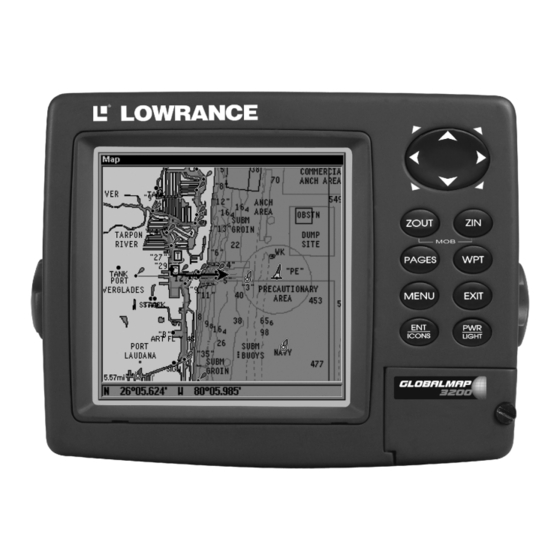
Page 27: Section 3: Basic Gps Operations
BUT, if you just can't wait to get outside, turn to the one-page Quick Reference on page 33. Keyboard GlobalMap 3200 GPS unit, front view, showing full map screen, key- board and access door for the MMC slot. 1. PWR/LIGHT (Power & Light) – The PWR key turns the GlobalMap 3200 on and off and activates the backlight. -
Page 28: Power/Lights (Turn Unit On And Off)
3 seconds. Main Menu The GlobalMap 3200 has a Main Menu, which contains some function commands and some setup option commands. The tutorial lessons in this section will deal only with functions, the basic commands that make the unit do something. - Page 29 Point of Interest or map cursor location; or after you reach the end of a route or trail. GPS Setup command: sets various GPS receiver options. System Setup command: sets general configuration options. Sun/Moon Calculations command: finds the rising and setting time of the sun and the moon.
-
Page 30: Satellite Status Page
Pages The GlobalMap 3200 has three Page displays that represent the three major operating modes. They are the Satellite Status Page, the Naviga- tion Page and the Map Page. They are accessed by pressing the key, then using → or ← to select a Page. (Clear the Pages Menu by... -
Page 31: Navigation Page
In other words, if the EPE shows 50 feet, then the position shown by the GlobalMap 3200 is estimated to be within 50 feet of the actual location. This also gives you an indicator of the fix quality the unit currently has. - Page 32 The navigation screen looks like the one below when you're not navi- gating to a waypoint or following a route or trail. Your position is shown by an arrow in the center of the screen. Your trail history, or path you've just taken, is depicted by the line extending from the arrow. The arrow pointing down at the top of the compass rose indicates the cur- rent track (direction of travel) you are taking.
- Page 33 to the destination. No matter what direction you are steering, the Bearing window shows the compass direction straight to the destina- tion from your location at the moment. Distance shows how far it is to the waypoint you're navigating toward. The Off Course window shows the current cross track error.
-
Page 34: Map Page
Map Page The Map Page screens show your course and track from a "bird's-eye" view. By default, this GlobalMap 3200 shows the map with north always at the top of the screen. (This can be changed. See the topic Map Orienta- tion, in Sec. - Page 35 Far left, Map Page opening screen. Center, zoomed to 100 miles and right, zoomed to 10 miles. Over Zoomed means you have reached the detail limits in an area covered only by the basic background map. Zooming in any closer will reveal no more map details because a high- detail custom map has not been loaded on the MMC for this area.
- Page 36 The medium-detail U.S. maps contain: all incorporated cities; shaded met- ropolitan areas; county boundaries; shaded public lands (such as national forests and parks); some major city streets; Interstate, U.S. and state high- ways; Interstate highway exits and exit services information; large- and medium-sized lakes and streams;...
- Page 37 can reduce screen clutter and make streets and other map features easier to see by simply turning off the display of POIs you're not watching for. (To see how, check the text on Map Detail Category Selection, page 79. It shows how to use the Map Categories Drawn menu to turn individual POI displays off and on.) Even though their display is turned off, you can still search for POIs and their icons will pop-up when your unit finds them for you.
- Page 38 The following page contains a 12-step quick reference for the most basic GPS operations. If you don't want to carry the manual with you as you practice with the GlobalMap 3200, you might consider photocopying this quick reference page and tucking it into your pocket.
-
Page 39: Basic Gps Quick Reference
Basic GPS Quick Reference Start outdoors, with a clear view of the open sky. As you practice, try navigating to a location at least a few blocks away. While you're learning, navigation in too small an area will constantly trigger arrival alarms. 1. -
Page 40: Find Your Current Position
If for some reason satellite acquisition takes longer, you may be inside a structure or vehicle or in terrain that is blocking signal reception. To correct this, be sure you are positioned so that the GlobalMap 3200's antenna module has as clear a view of the sky as possible, then turn the unit off and back on again. -
Page 41: Selecting Any Map Item With The Cursor
On most items, a pop-up box will give the name of the selected item. Searching Now that you've seen how the GlobalMap 3200 can find where you are, let's search for something somewhere else. Searching is one of the most powerful features in the Eagle GPS product line. - Page 42 3. The GlobalMap 3200 says it is calculating, then a list of restaurants appears, with the closest at the top of the list, and the farthest at the bottom of the list. The nearest is highlighted. Find Waypoint Menu, left; Category Selection menu, center; and list of 4.
-
Page 43: Set A Waypoint
6. The GlobalMap 3200's map appears, with the cross-hair cursor high- lighting the restaurant's POI symbol. A pop-up name box identifies the POI. A data box at the bottom of the screen continues to display the location's latitude and longitude, distance and bearing. -
Page 44: Create Waypoint At Current Position
To create and save a Waypoint: These first two techniques use the Quick Save method, the fastest and easiest way to create a waypoint. Create Waypoint at Current Position While you are traveling, press automatically given a name with a sequential number, such as "way- point 003."... -
Page 45: Create Waypoint On Map
NOTE: The Quick Save method uses the default waypoint symbol until you edit an existing waypoint and change its symbol. (Edit Waypoint Symbol is described in Sec. 4.) After you have changed a waypoint symbol, the unit will remember the one you chose and use it the next time you "quick save"... -
Page 46: Set Man Overboard (Mob) Waypoint
3. If the list is short, you can jump directly to the . Use ↑ or ↓ to select the waypoint name, press pressing waypoint information screen appears with the 4. To begin navigating to the waypoint, press Course line (dotted) Off course range, set at... -
Page 47: Navigate To Cursor Position On Map
|↓ to MENU MENU ANCEL AVI- |← to . The GlobalMap 3200 stops showing naviga- GATION tion information. Navigate to Cursor Position on Map command: navigates to the current cursor position on URSOR the map. It's a quick and handy way to navigate to anything you can see on the map display. - Page 48 The Navigation Page, right, will also show navigation information. To stop navigating to the cursor, use the Cancel Navigation command: press |↓ to |← to . The MENU MENU ANCEL AVIGATION GlobalMap 3200 stops showing navigation information.
-
Page 49: Navigate To A Point Of Interest
The GlobalMap 3200 is set at the factory to automatically create and record a trail while the unit is turned on. The GlobalMap 3200 will con- tinue recording the trail until the length reaches the maximum trail point setting (default is 2,000, but the unit can record trails 9,999 points long). - Page 50 Active symbol Visible symbol Sequence for saving a trail and beginning a new one. At left, My Trails command. Center, the Trails Menu. The arrow to the right of Trail 14 indicates the trail is "active," and the check to the left indicates the trail is visible on the map display.
-
Page 51: Displaying A Saved Trail
Tip: Another quick way to stop recording one trail and begin a new one is to use the New Trail command: Press RAILS Caution: You also have the option of completely turning off trail record- ing, under the trail Options command. However, if the Update Active Trail option is left turned off, it will cancel the automatic trail creation feature. -
Page 52: Visual Trailing
Enter. Just press clear the alarm and proceed. 5. Now, begin moving and follow your GlobalMap 3200. 6. When you reach your destination, be sure to cancel your navigation: press |↓... - Page 53 Figure 1. Navigate a trail menu sequence: Fig. 1, My Trails command. Fig. 2, Trails Menu. Fig. 3, Edit Trail Menu. Fig. 4, Edit Route Menu with Navigate command highlighted for Trail 6. A trail is always converted to a "route" when you navigate the trail. On the Map Page, the trail you are navigating is represented by a dot- ted line that alternates with a flashing solid line.
-
Page 54: Navigate A Back Trail (Backtrack, Or Reverse)
Custom Maps: Custom maps work only from the MMC card or SDC card. When a card containing a Custom Map File is loaded into the unit, the GlobalMap 3200 automatically loads the map into memory when the unit is turned on. -
Page 55: Gps Data Files
2. The Transfer My Data menu includes a message which tells you if an MMC is present or not. If no MMC is present, you must first insert a card into the GlobalMap 3200 in order to activate the Load or Save commands. - Page 56 EXIT From left to right, these figures show the menu sequence for naming and saving a GPS Data File from the GlobalMap 3200's memory to an 4. Loading to unit memory: There may be more than one GPS Data File (*.USR) on the card. To select a file, press tion box, use ↓...
-
Page 57: Cancel Navigation
Figure 1. Figure 2. Figure 3. Figure 4. These figures show the menu sequence for loading a GPS Data File from an MMC into the unit's memory. Cancel Navigation You can turn off any of the navigation commands after you reach your destination or at any other time by using the Cancel Navigation com- ←... - Page 58 Notes...
-
Page 59: Section 4: Advanced Gps Operations
Advanced GPS Operations Find Distance From Current Position To Another Location 1. While on the Map Page press: 2. Center your cursor over the position you want to find the distance to. A rubber band line appears, connecting your current position to the cursor's location. -
Page 60: Icons
Icons Icons are graphic symbols used to mark some location, personal point of interest or event. They can be placed on the map screen, saved and re- called later for navigation purposes. These are sometimes referred to as event marker icons. This unit has 42 different symbols you can pick from when creating an icon. -
Page 61: Navigate To An Icon
1. Press |↓ to MENU 2. Press ↓ to ELETE press ENT The Delete All Icons command will ask if you are sure. Press ← to . All icons will be deleted from the map. The Delete by Symbol command will launch the Select Symbol menu. Press ←... -
Page 62: Create And Save A Route
A route provides the automatic capability to navigate through several waypoints without having to reprogram the unit after arriving at each waypoint. Once programmed into the GPS unit, a route provides the option of navigating forward through the route waypoints or in reverse order (you can even begin navigating in the middle of a route!) Create and Save a Route You have the option of creating and editing a route in the unit, or you... - Page 63 Edit Route menu, left. Edit Route Waypoints menu, right, with Add From Map command selected. 3. Use the Zoom keys and arrow keys to move the map and cursor until the cursor is centered on the spot where you want your route to begin. (If you are starting at your current position or the current cursor posi- tion, you are already at the starting spot.) 4.
-
Page 64: Delete A Route
Route creation sequence, continued: Fig. 4. Point (3) set at on-ramp turn. Fig. 5. Waypoint (4) set at highway exit to frontage road leading to river. Waypoint (5) ends the route at a tree stand in the hunting area. Fig. 6. Press EXIT to save the route and you return to this screen. 5. -
Page 65: Edit A Route
Edit a Route You can edit the route name if you wish. 1. From the AVIGATION press |↓ to MENU MENU 2. Press ↓ to route name| 3. Press ↑ or ↓ to change the first character, then press → to move the cursor to the next character and repeat until the name is correct, then press Return... -
Page 66: Navigate A Route In Reverse
Route Planning command on Main Menu, left; Routes menu, center; Edit Route menu, right. Navigate command is selected in the Action box. 2. Press ↓ to select route name| 3. Upon arrival at your destination, cancel navigation: press |↓ to MENU MENU The following figures show what the Navigation Page and Map Page... -
Page 67: Trails
Figure 1. Figure 3. Navigating along a route: Fig. 1 shows the Navigation Page at the start of a route, heading straight for the first waypoint (Wpt 1). In Fig. 2, the traveler has arrived at Wpt 1; the arrival alarm has been triggered and the bearing arrow on the compass rose has turned to point toward Wpt 2, off to the east. -
Page 68: Edit A Trail Color
Tip: You can quickly call up the Edit Trail menu by selecting a trail on the map with the cursor. Simply move the cursor over a trail and a pop-up box appears. Press At left, trail selected with map cursor. The pop-up box shows distance and bearing from current position to the selected point on the trail. -
Page 69: Alarm Clock
Alarm Clock To get to the alarm clock menu: press LARM LOCK Sun/Moon Rise & Set Calculator To get to the Sun/Moon menu: press ALCULATIONS Trip Calculator To get to the Calculator menu: press LATOR Trip Down Timer To get to the Down Timer menu: press IMER Trip Up Timer To get to the Up Timer menu: press... -
Page 70: Selecting A Waypoint
2. Use arrow keys to select desired symbol and press the previous page, press Waypoint Position To edit waypoint position: 1. Press name| |↓ to 2. Latitude: press → to character, then press → to the next character and repeat until the lati- tude is correct. - Page 71 3. Press → to HOOSE map feature or Point of Interest. When the point has been selected, press and the point's position appears as the reference position. 4. Press ↓ to ISTANCE then press → to the next character and repeat until the distance is cor- rect.
- Page 72 Notes...
-
Page 73: Section 5: System & Gps Setup Options
Section 5: System & GPS Setup Options Alarms This unit has several GPS alarms. The factory default setting has all the alarms turned on. You can turn the alarms off and on and change their distance settings. You can set an arrival alarm to flash a warning message and sound a tone when you cross a preset distance from a waypoint. -
Page 74: Auto Satellite Search
(altitude) is. It does know the current UTC time and date since these were programmed into it at the factory and an internal clock keeps the time while the GlobalMap 3200 is turned off. (If the time and/or date are incorrect, you can set it using the "Set Local Time"... -
Page 75: Check Mmc Files And Storage Space
Main Menu, left, MMC File Browser, right. Communications Port Configuration The GlobalMap 3200 has one NMEA 0183 version 2.0 compatible com- munication port, or com port for short. The Com Port Menu, which is accessed from the System Setup Menu, allows you to configure the communications port to send or receive data to another electronic de- vice, such as an autopilot. -
Page 76: Configure Dgps
Menus for changing Com Port settings. For connectors and wiring information for another device, see page 13. For assistance in configuring the GlobalMap 3200 to communicate with another device, consult the factory; customer service phone numbers are in the back of this manual. Also see the entries below for Configure DGPS and Configure NMEA. -
Page 77: Configure Nmea
Configure NMEA You can configure the GlobalMap 3200 to use specific NMEA sentences. 1. Press MENU MENU 2. Press ↓ to OMMUNICATIONS 3. A menu appears showing the prefixes of the available NMEA sen- tences. A check mark next to a prefix means the prefix is in use. Use ↑... -
Page 78: Map Fix
In order to use these grid systems, you must be in the respective country. This GlobalMap 3200 will pick the matching datum for you when you select the grid. See the entry on Map Datum Selection for more information. - Page 79 Configure a map fix so the unit can find your position on a printed Press ↓ to ELECT lect the waypoint that you saved the reference point under and press . The GlobalMap 3200 displays a waypoint information screen with the command the Configure Map Fix menu. Finally, press |↓ to...
-
Page 80: Customize Page Displays
EXIT EXIT GPS Simulator The GPS simulator lets you use the GlobalMap 3200 as if you were out- doors navigating somewhere. It's a great way to practice using your unit. You can set the starting location by entering latitude/longitude (Starting Position) or from a stored waypoint, map place or POI loca-... - Page 81 A message and tone appears periodically, warning you that the simulator is on. To turn the simulator off, repeat the above steps or turn the GlobalMap 3200 off. While in simulator mode, you can press speed boxes from the screen while continuing the simulation. This will allow you to use the map cursor during a simulation.
-
Page 82: Initialize Gps
4. Press to turn off the steering and speed boxes. The GlobalMap EXIT 3200 will now automatically "steer" along the trail or route. When you arrive at your "destination," cancel navigation as you normally do. Tip: You can pick any spot on the map to begin your simulation session by using the Initialize GPS command. -
Page 83: Map Data
Map Data This menu lets you turn the map off, if desired (which turns the map screen into a GPS plotter); turn off or on the pop-up map info boxes; draw the map boundaries or boxes around the areas of high detail; or fill land areas with gray. -
Page 84: Map Overlays (Range Rings; Lat/Long Grid)
Map Overlays (Range Rings; Lat/Long Grid) The map screen can be customized with four range rings and/or grids that divide the plotter into equal segments of latitude and longitude. Range rings are handy for visually estimating distances on the map. The ring diameters are based on the current zoom range. -
Page 85: Map Detail Category Selection
GPS Setup Menu, left, Map Datum Menu, right. Map Detail Category Selection This menu determines which of the mapping features are shown on the screen. This includes, waypoints, trails, icons, cities, highways, etc. You can selectively turn on or off any of these items, customizing the map to your needs. - Page 86 In Track Up mode, map shows "N" and arrow to indicate north. Map orientation at left is shown in north up and at right, track up. This is fine if you're always traveling due north. What you see to your left corresponds to the left side of the map, to your right is shown on the right side of the map, and so on.
-
Page 87: Navionics Charts
Navionics Charts Your GlobalMap 3200 can display Navionics MMCs. They work just like a MapCreate custom map on an MMC. Left, entrance to Chesapeake Bay in a MapCreate 6 custom map, 10 mile zoom. Center, same position on Navionics chart at 11.15 mile zoom To display a Navionics chart: 1. -
Page 88: Port Information
Port Information Navionics charts contain Port Services information, represented by an- chor icons on the map display. An example is displayed in the following figure. To view Port Services information: 1. Use the arrow keys to move the cursor over a Port Services icon. When selected, a pop-up name box appears. -
Page 89: Tidal Current Information
Port Services information screens. Tidal Current Information Navionics charts contain Tidal Current information, represented at large zoom ranges by a box icon with the letter "C." The icon stands for a Tidal Current Station location. An example is displayed at right. When you zoom in to a sufficiently small zoom range, the icon itself be- comes an animated arrow showing tidal current velocity and direction for the selected tidal station at the present time. -
Page 90: Tide Information
Current Information screen. The Tidal Current Information screen displays daily tidal current data for this station on this date at the present time. The graph at the top of the screen is an approximate view of the flood and ebb pattern for the day, from midnight (MN), to noon (NN) to midnight (MN). -
Page 91: View Tide Information
To view tide information: 1. Select a Tide Station icon: use the arrow keys to move the cursor over an icon. When it is selected, a pop-up name box appears. 2. After selecting the Tide Station icon, press Information screen. Cursor line Tide Station icon... -
Page 92: Pop-Up Help
The Position Pinning feature was developed so that when you stopped, the GlobalMap 3200 locked the present position on the GPS plotter un- til you moved a short distance or exceeded a very slow speed. -
Page 93: Reset Options
Reset Options Menu, right. Require DGPS You can force the GlobalMap 3200 to require DGPS for reporting a valid position. (The default setting, off, uses DGPS automatically when an optional DGPS beacon receiver is connected. However, this auto mode doesn't require DGPS reception to yield a position.) Here's how to... -
Page 94: Screen Contrast And Brightness
GPS Setup command, left; Require DGPS command on the GPS Setup Menu, right. Screen Contrast and Brightness To access the Screen menu, press MENU MENU Once in the Screen menu: To adjust the display's contrast: slider bar is already selected. Press → or ← to move the ONTRAST bar. -
Page 95: Set Language
Set Language This unit's menus are available in 10 languages: English, French, Ger- man, Spanish, Italian, Danish, Swedish, Russian, Dutch and Finnish. To select a different language: 1. Press MENU MENU 2. Press ↓ to ANGUAGE 3. Use ↓ or ↑ to select a different language and press now appear in the language you selected. -
Page 96: Show Waas Alarm
The last field in this menu is GlobalMap 3200 to automatically adjust with the time change caused by Daylight Saving Time (you should only have to set it once). You may select which set of rules matches DST in your region, or simply accept the default. -
Page 97: Sounds And Alarm Sound Styles
1. Press MENU MENU 2. Read the information displayed on the screen. 3. To return to the last page displayed, press Sounds and Alarm Sound Styles Sounds triggered by key strokes and alarms can be adjusted: You first press MENU Sounds command, left. -
Page 98: Trail Options
Track Smoothing option, turned on. Trail Options There are several options you can use with trails. Some affect all trails, other options can be applied to a particular trail. You can change the way trails are updated, you can display or hide trails, make them flash on the screen or not flash, create a new trail, delete a trail, etc. -
Page 99: Update Trail Criteria (Auto, Time, Distance)
Once you deviate from a straight line, the GlobalMap 3200 "drops" a plot point (trail waypoint) onto the trail. This conserves plot trail points. If a plot trail uses all of the available points allotted to it, the beginning points are taken away and placed at the end of the trail. -
Page 100: New Trail
New Trail To manually start a new trail, in the Trails Menu, make sure is highlighted and press Trail Visible/Invisible and Other Trail Options The name, maximum number of points in the trail, activity, and visibility are all changed on the Edit Trail menu screen. The Active setting deter- mines whether or not the unit is recording new points for a particular trail. -
Page 101: Section 6: Searching
MapCreate maps, see page 28. This GlobalMap 3200's varied search functions all begin with either the Find Waypoint menu or the Map Page menu. Press Waypoint menu appears for waypoints and Points of Interest (POI). - Page 102 Find Address Menu. 3. To enter an address number, press ↑ or ↓ to change the first number, then press → to move the cursor to the next number and re- peat until the number is correct, then press 4. To enter a street name, press ↓ to .
- Page 103 Find city field, left, Search in particular city only option, center; Find 6. When the necessary search fields are filled in, press ↓ to . Your GlobalMap 3200 asks you to wait while it searches for DRESS the address. (If an address is not in the database, a message appears saying the address could not be found.)
-
Page 104: Find Any Item Selected By Map Cursor
8. To navigate to the address, press Map 3200 will begin showing navigation information to the address pointed out by the cursor. If you are only looking up an address (not navigating), just press Tip: If the address also happens to be an item in the Point of Interest database, you can look up the item's phone number in the Waypoint Information list. -
Page 105: Find Interstate Highway Exits
NOTE: Since the Go To Waypoint command is highlighted, you can navi- gate to the selected POI by pressing Waypoint Information screen. Find Interstate Highway Exits 1. From the Map Page, press up the Find Exit menu. Find Highway Exits command, left, and Find Exit menu, right. 2. - Page 106 3. Once you have selected a highway name you can then select an exit. Press ↓ to switch to the Exit List, then press ↓ or ↑ until you highlight the exit, then press Find Exit menu, with an exit selected in the Exit List. 4.
-
Page 107: Find Map Places Or Points Of Interest (Poi)
Exit Information screen, left; general location and amenities information, at right. Find Map Places or Points of Interest (POI) ↓ ↑ 1. Press , press to select a map place or POI category, then . (To narrow your search, press → then press ↓ or ↑ to select a press subcategory before pressing .) You will be given two options;... - Page 108 Find By Nearest option, left, Calculating screen, center, POI list, right. 3. Search by name of POI. Press . There are two options: A. You can spell out the POI in the top selection box. Press ↑ or ↓ to change the first letter, then press →...
-
Page 109: Find Streets Or Intersections
"Go To" POI option, left, "Find on Map" POI option, right. Find Streets or Intersections Find a Street 1. From the Map Page, press |↓ to and the Find MENU TREETS Streets Menu appears. Find Streets command, left, Find Streets menu, right. 2. - Page 110 ↓ to . A message appears asking IRST TREET you to wait while the GlobalMap 3200 finds the street. When the Streets Found list appears, press ↑ or ↓ to select the street you are searching for and press ENT.
- Page 111 Map Page showing results of a street search. The cursor points to the located street. If you want to navigate to the found street at the cursor location, just press MENU EXIT Find an Intersection You must enter one street in the First Street dialog box and enter the next street in the Second Street dialog box.
- Page 112 6. To search for the intersection of the two streets, press ↓ to . A message appears asking you to wait while the NTERSECTION GlobalMap 3200 finds the intersection. When the Intersections Found list appears, press ↑ or ↓ to select the intersection you are searching for and press .
-
Page 113: Find Waypoints
5 below.) Find Waypoint menu, left; Find By Nearest command, center, 3. If you're looking for nearest, the GlobalMap 3200 says it is cal- culating, then a list of waypoints appears. The closest is highlighted at the top of the list and the farthest at the bottom of the list. - Page 114 Map Page. A. To navigate to the waypoint, press mand is already highlighted.) The GlobalMap 3200 will show navi- gation information to the waypoint. B. To find the waypoint, press ↓ to pears with the cursor highlighting the found waypoint.
-
Page 115: Section 7: Supplemental Material Datums Used By This Unit
Section 7: Supplemental Material Datums Used by This Unit WGS 1984 Default Adindan Mean for Ethiopia, Sudan Adindan Burkina Faso Adindan Cameroon Adindan Ethiopia Adindan Mali Adindan Senegal Adindan Sudan Afgooye Somalia Ain el Abd 1970 Bahrain Ain el Abd 1970 Saudi Arabia Anna 1 Astro 1965 Cocos Islands... - Page 116 DOS 1968 New Georgia Islands (Gizo Island) Easter Island 1967 Easter Island European 1950 Mean for Austria, Belgium, Denmark, Finland, France, West Germany, Gibraltar, Greece, Italy, Luxembourg, Netherlands, Norway, Portugal, Spain, Sweden, Switzerland European 1950 Mean for Austria, Denmark, France, West Germany, Netherlands, Switzerland European 1950...
- Page 117 North American 1927 Mean for CONUS (Continental United States) North American 1927 Mean for CONUS (East of Mississippi River) including Louisiana, Missouri, Minnesota North American 1927 Mean for CONUS (West of Mississippi River) North American 1927 Alaska North American 1927 Bahamas (Except San Salvador Island) North American 1927...
- Page 118 Bolivia, Brazil, Chile, Colombia, Ecuador, Guyana, Paraguay, Peru, Trinidad & Tobago, and Venezuela South American 1969 Argentina South American 1969 Bolivia South American 1969 Brazil South American 1969 Chile South American 1969 Colombia South American 1969 Ecuador South American 1969 Ecuador (Baltra, Galapagos) South American 1969...
-
Page 119: Fcc Compliance
This device complies with Part 15 of the U.S. Federal Communications Commission (FCC) Rules. Operation is subject to the following two conditions: (1) this device may not cause harmful interference, and (2) this device must accept any interference received, including interference that may cause undesired operation. - Page 120 Notes...
- Page 121 Notes...
- Page 122 Notes...
- Page 123 LOWRANCE DATABASES LICENSE AGREEMENT THIS IS A LEGAL AGREEMENT BETWEEN THE END-USER WHO FIRST PURCHASES THIS PRODUCT AS A CONSUMER ITEM FOR PERSONAL, FAMILY, OR HOUSEHOLD USE ("YOU") AND LOWRANCE ELECTRONICS, INC., THE MANUFACTURER OF THIS PRODUCT ("WE", "OUR", OR "US"). USING THE PRODUCT ACCOMPANIED BY THIS LICENSE AGREEMENT CONSTITUTES ACCEPTANCE OF THESE TERMS AND CONDITIONS.
-
Page 124: Databases Limited Warranty
DATABASES LIMITED WARRANTY "We", "our", or "us" refers to Lowrance Electronics, Inc., the manufacturer of this product. "You" or "your" refers to the first person who purchases the product as a consumer item for personal, family, or household use. The Databases Limited Warranty applies to the one or more databases that your product may contain. - Page 125 LOWRANCE ELECTRONICS FULL ONE-YEAR WARRANTY "We," "our," or "us" refers to LOWRANCE ELECTRONICS, INC., the manufacturer of this product. "You" or "your" refers to the first person who purchases this product as a consumer item for personal, family or household use. We warrant this product against defects or malfunctions in materials and workmanship, and against failure to conform to this product's written specifications, all for one (1) year from the date of original purchase by you.
-
Page 126: How To Obtain Service
How to Obtain Service… …in the USA: We back your investment in quality products with quick, expert service and genuine Lowrance parts. If you're in the United States and you have technical, return or repair questions, please contact the Factory Customer Service Department. -
Page 127: Accessory Ordering Information For All Countries
Accessory Ordering Information for all countries To order Lowrance GPS accessories such as computer cables or MMC cards, please contact: 1) Your local marine dealer or consumer electronics store. Most quality dealers that handle marine electronic equipment or other consumer electronics should be able to assist you with these items. -
Page 128: Visit Our Website
Visit our web site: Lowrance Pub. 988-0105-981 © Copyright 2002 All Rights Reserved Printed in USA 102502 Lowrance Electronics, Inc.
Need help?
Do you have a question about the GlobalMap 3200 and is the answer not in the manual?
Questions and answers