Garmin GPS 76 Owner's Manual
Gps navigator
Hide thumbs
Also See for GPS 76:
- Declaration of conformity (1 page) ,
- Safety and product information (40 pages) ,
- Specification sheet (2 pages)
Table of Contents
Advertisement
Advertisement
Table of Contents

Related Manuals for Garmin GPS 76


Summary of Contents for Garmin GPS 76
- Page 1 GPS 76 owner’s manual & reference guide...
- Page 2 GARMIN website for current updates and supplemental information concerning the use and operation of this and other GARMIN products. Website address: www.garmin.com GARMIN is a registered trademark and eTrex is a trademark of GARMIN Corporation and may not be used without the express permission of GARMIN Corporation. July 2001 Part Number 190-00229-00 Rev.
-
Page 3: Introduction
Thanks for choosing the GARMIN GPS 76. If you have any questions or com- ments regarding the use of the GPS 76 you can visit our website or contact our Customer Service Department M-F, 8:00-5:00 CST (except holidays) at 1-800- POWER 800-1020. -
Page 4: Warnings And Cautions
WARNING: If you choose to use the GPS 76 in a vehicle, it is the sole responsibility of the owner/operator of the GPS 76 to secure the GPS unit so that it will not cause damage or personal injury in the event of an accident. Do not... -
Page 5: Fcc Compliance Statement
FCC Compliance Statement including interference that may cause undesired operation. The GPS 76 does not contain any user-serviceable parts. Repairs should only be made by an authorized GARMIN service center. Unauthorized repairs or modifi cations could result in permanent damage to the equipment, and void your... -
Page 6: Features
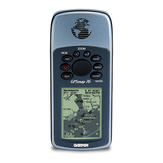
The GPS 76 is a 7.5 ounce, 12 channel, hand held GPS receiver with a built-in Quad Helix antenna. The GPS 76 has nine keys located on the front of the unit, that allow the user to quickly access all of the units functions. The GPS 76 has a large 180 Introduction X 240 pixel, 4 level gray monochrome display for easy viewing. -
Page 7: Table Of Contents
Table of Contents ....... 5 Points of Interest......42 “How To” Index........6 Cities .......... 42 Appendix G: Loran TD....67-68 GPS 76 Unit Features ......7 Routes ........43-47 Appendix H: Accessories ....69 Section One: Getting Started ..8-20 Proximity........47 Appendix I: Index ...... -
Page 8: How To" Index
Access the Main Menu ........10, 35 your new GPS 76. -
Page 9: Gps 76 Unit Features
Introduction Internal Antenna GPS 76 Unit Features External Antenna Connection Battery Compartment Interface Keys External Data/Auxilary Power Port 180 x 240 Four Level Gray, Backlight Display... -
Page 10: Section One: Getting Started
Turn D-ring 1/4 turn counter- Installing the Batteries clockwise and remove cover Remove the batteries from your GPS 76 if you don’t expect to use it for several months. Be sure to observe the proper Installing the batteries polarity when inserting the batteries. Follow the battery man- Installing the batteries: ufacturer’s instructions on the proper care and handling of... -
Page 11: Installing The Lanyard
Getting Started Installing the Lanyard To install the Lanyard: 1. Place the loop of the Lanyard through the slot opening at the bottom of the GPS 76. 2. Route the strap through the loop and pull tight. -
Page 12: Interface Keys
ENTER — The ENTER Key is used to activate a data fi eld or confi rm a selection. If the ENTER Key is pressed and held, the GPS 76 will store the current location and display the Mark Waypoint page. -
Page 13: Main Pages
Page. You can cycle through these pages by pressing either the PAGE or QUIT Key. When the GPS 76 is turned on a Welcome Page will be displayed, followed by a Warning Page. Acknowledge these pages by pressing the PAGE Key while they are displayed. -
Page 14: Using The Built-In Simulator
While learning the basic operation of the GPS 76, let’ s put the unit into Simulator Mode. The Simulator Mode is great for practicing with the unit while inside and satellite signals are not available. When the GPS 76 is in Simulator... -
Page 15: Using The Interface Keys
The Interface Keys are your link with the GPS 76. Let’ s take a few minutes and see what some of the Interface Keys are used for. With the GPS Information Page displayed, press the PAGE Key several times. Getting Started Notice that each time you press the PAGE Key the next main page will be displayed. -
Page 16: Entering Data
Symbol Field Name Field a Route. Creating or ‘Marking’ a waypoint with the GPS 76 is easy. The unit has to be turned on and receiving at least three satellites (or simulating navigation) to mark a waypoint. Marking a waypoint: 1. - Page 17 1. Using the ROCKER Key, highlight the ‘OK’ Button and press the ENTER Key. These are the same steps that you will use to enter names and change numbers and select options in all of the fi elds in the GPS 76. Here are a couple of tips:...
-
Page 18: Basic Navigation
You should now have enough knowledge to navigate through the main pages, Option Menus and enter data into your GPS 76. Now let’ s learn how to navigate! The main use of a GPS is to be able to navigate to a known position. We have Getting Started already created a waypoint and named it CREEK. -
Page 19: Getting Started
For a GPS to navigate, it has to be moving, and fortunately you can simulate movement in the GPS 76. Press the PAGE Key until the Pointer Page is displayed. Along the top of the Pointer Page there are several data fi elds. The Speed Field is located in -the upper left corner. -
Page 20: Initializing The Gps 76
1. With the GPS Information Page displayed, press the MENU Key. 2. Select ‘Stop Simulator’ then press the ENTER Key. Before the GPS 76 can be used for navigation, the receiver has to be initialized. This process is automatic and will only take a few minutes. - Page 21 5. Press the PAGE Key until the Map Page is displayed. Current Begin walking holding the GPS 76 in front of you with the top of the unit Track 45° pointed toward the sky. As you move, you will see that the unit leaves a bread crumb trail on the map indicating where you have been.
- Page 22 HOME waypoint, a message will be displayed alerting you that you have arrived. Basic Navigation Congratulations, you should have enough basic knowledge of your GPS 76 to begin navigating on your own. Be safe; remember that while the GPS is very DESTINATION reliable, you should always have a backup means of navigation.
-
Page 23: Section Two: Reference
Each time the unit is used, the Almanac is updated. This is how the GPS 76 knows which satellites to search for. If you do not use your GPS for several months, or move the unit several hundred miles between uses, the Almanac can become “cold”, that is to say that the orbital... - Page 24 Initialization Options If the GPS 76 is unable to determine its location, an options menu will be displayed. Depending on the situation, select an option to help the unit acquire Getting Started Reference satellites. To select an option, place the highlight over the option then press ENTER.
-
Page 25: Gps Information Page
Simulating GPS — Indicates the GPS 76 is running in Simulator Mode and the GPS receiver is turned off. It is important to remember when you are using the Simulator, the GPS 76 can not be used for actual navigation. - Page 26 Satellite Location The location of each available satellite is displayed over two location rings. The outer ring represents the horizon, the inner ring represents 45° above the Getting Started Reference horizon and the center represents directly overhead. When the unit is using a satellite for navigation, the satellite number will become highlighted on the GPS Information Page location rings.
- Page 27 GPS Information Page Options Menu To activate the Options Menu from the GPS Information Page, press the MENU Key. To select an option, highlight the desired selection then press Getting Started Reference ENTER. GPS Information Page Start/Stop Simulator — This option is used to Start or Stop the Simulator. This option determines if the satellites are displayed with Track Up/North Up —...
-
Page 28: Map Page
Map Page The GPS 76 comes with a factory-loaded marine point database that includes marine navaids and major cities. This can be replaced with marine navaids, cities, Getting Started Reference and points of interest using GARMIN MapSource products. Changing the Zoom Scale... - Page 29 Setup Page Layout — This option allows you to select the number of data fi elds rows and the size of text used in the fi elds. You have the option of displaying Small (1 Row), Small (2 Rows), Small (3 Rows), Medium (1 Row), Getting Started Reference Medium (2 Rows), Medium (3 Rows), Large (1 Row), or Large (2 Rows).
- Page 30 If you select ‘Off’, the items for that option will not be displayed on the Map Page. If you select ‘Auto’, the GPS 76 will automatically determine the zoom level at which to display the selected items. If you select a scale setting, the...
- Page 31 Setup Map — ‘Map’ Tab The ‘Map’ Tab contains settings for the Basemap, MapSource, Lat Lon Grids, and Grid Labels. To change a setting, highlight the appropriate Getting Started Reference fi eld then press ENTER. Make your new selection then press ENTER to accept the selection.
- Page 32 This option sets the display parameters for waypoints Active Route Waypoint — that are in an Active Route. As an example, if you have selected ‘Small’ as the text option for all waypoints, but selected ‘Large’ as the setting for Active Getting Started Reference Route Waypoints, the waypoints included in an Active Route will be displayed...
-
Page 33: Map Page Options
are Track Logs that have been saved in the units memory. Saved Tracks — Course Lines — controls the display of the Route Line and Go To Line. The Bearing Line will show the bearing from your current Bearing Line — Getting Started Reference location to the active waypoint. -
Page 34: Pointer Page
Pointer Page The Pointer Page is best used for navigation when a straight line course can not be followed. The Pointer Page has User Selectable Data Fields along the top, a Getting Started Reference Active Waypoint Field, Compass Ring and a Pointer. The Compass Ring is a graphic display of your current track. -
Page 35: Highway Page
Highway Page The Highway Page is best used for navigation when a straight line course can be followed. The Highway Page has User Selectable Data Fields along the top, a Getting Started Reference Status Bar, and the Highway Display. The Highway Page shares many features with the Map Page. Any tracks, saved Highway Page tracks or waypoints that are within the display area will be shown, the Zoom Level can be changed using the IN and OUT Keys, and the Triangle represents... - Page 36 This option allow you to select the type of data you want Change Data Fields — displayed in the data fi elds. To change a data type, place the highlight over the desired data fi eld, then press ENTER. Using the ROCKER, scroll through Getting Started Reference the available selections.
-
Page 37: Main Menu Page
This setting determines if the next waypoint in a Route will be Next — displayed. If ‘On’ is selected, you will see the next waypoint in the Route. If ‘On’ is selected and the Route option is set to ‘Off’, only the Next Waypoint Getting Started Reference in the Route will be displayed. -
Page 38: Trip Computer
The Moving Average (Speed) fi eld will display an average speed Moving Avg — based on the time the unit was in motion since the Trip Computer was last reset. Getting Started Reference Moving Time — The Moving Time fi eld will display the total time the unit was in motion since the Trip Computer was last reset. -
Page 39: Tracks
Tracks The Tracks Page displays the amount of Track Memory used, will allow you to ‘Save’ or ‘Clear’ the current Track Log, and displays a list of any Saved Tracks. Getting Started Reference Save — When you select ‘Save’ you can choose how far back in the log you wish to save. - Page 40 Name — this fi eld will allow you to change the Saved Track Name. When tracks are saved the GPS 76 will use a date as the default track name. Distance — shows the total distance of the Saved Track.
-
Page 41: Waypoints
fi eld or scrolling through the Waypoint List. As you enter a waypoint name, the GPS 76 will update the waypoint list to show waypoint names that coincide with the letters that have been entered. -
Page 42: Creating Waypoints
Creating Waypoints There are three methods for creating waypoints in the GPS 76. You can press the ENTER/MARK key while at a location, you can create a waypoint on the Map Getting Started Reference Page, or you can enter coordinates for a waypoint manually. -
Page 43: Editing Waypoints
Editing Waypoints You can edit waypoints when they are created or after they have been saved to memory. There are six items that can be changed, the symbol, name, location, Getting Started Reference elevation, depth, you can choose whether or not to show the waypoint name on the Map Page. -
Page 44: Points Of Interest
Points of Interest Will only be available when MapSource CD data that contains Points of Interest information is loaded in the unit. When ‘Points of Interest’ is selected, the Getting Started Reference Points of Interest Selection Page is displayed. To select a Points of Interest item, highlight the desired selection then press ENTER. -
Page 45: Routes
fi nish, but can contain as many as fi fty. The GPS 76 can store fi fty routes. On the Routes Page you can create ‘New’ routes, determine how many empty routes that you have left, and review a list of existing routes. - Page 46 ENTER a fi nal time to insert it into the route. If you place the Map Pointer on a Map Feature, the GPS 76 will only store that location in the route using the feature name as a reference. These points are not stored in the User Waypoint List.
- Page 47 GPS 76 will automatically name the route using the Naming the Route — fi rst and last waypoint names as a reference. To change the Route Name, place the highlight over the Name fi eld then press ENTER. When you have...
- Page 48 2. Place the Map Pointer over a location that is not a Map Feature then press ENTER. The New Waypoint Page will be displayed. Press ENTER to save the new waypoint. Place the Map Pointer over the route leg that you want Getting Started Reference to insert the waypoint into, then press ENTER.
-
Page 49: Proximity
To plan a route, enter a Speed, Fuel Flow, Depart Time and Plan Route — Depart Date. Fuel Flow is measured in “units per hour”. It may be necessary to consult your vehicle’ s Owner’ s Manual for performance specifi cations. Getting Started Reference The Active Route Page and Route Page display trip-planning information for... -
Page 50: Celestial
Celestial The Celestial Menu lets you view information for Tides, Sun and Moon, or Hunt and Fish. Getting Started Reference Main Menu Celestial Date Local Time Station Name Max Level Current Time Current Tide Level Night Low Tide Curve MLLW Min Level Main Menu —... - Page 51 The top of the page will display the date with the tide station below. The top of the chart will show a 24-hour block of local time (LCL) for your position, with the reported station time (STA) appearing at the Getting Started Reference bottom.
-
Page 52: Celestial
The Sun and Moon Page displays data for Sunrise/Sunset, Sun and Moon — Moonrise/Moonset, and the approximate location of the Sun and Moon on a skyview. The moon phase will display the current visible portion of the moon Getting Started Reference in a light shade. -
Page 53: Mapsource Info
fi eld on a tab, user the ROCKER Key (up/down) to highlight the selection then press ENTER. To restore the GPS 76 to the factory settings for items on the tab, press MENU and with ‘Restore Defaults’ highlighted press ENTER. -
Page 54: Setup Menu- General Tab
Pacifi c Ocean and one over the Atlantic Ocean. You must have a clear unobstructed view of the sky for the GPS 76 to be able to receive a WAAS signal, even then, at times it may not be possible to receive a WAAS signal. -
Page 55: Setup Menu-Time Tab
fi eld then press ENTER. Make your selection then press ENTER to activate the selection. ‘Time Format’ — Using this setting you can have the GPS 76 display time in a 12 or 24 hour format. The ‘Time Zone’ setting has nine options, Atlantic, Eastern, ‘Time Zone’... -
Page 56: Setup Menu-Units Tab
Setup Menu — ‘Units’ Tab The ‘Units’ Tab contains settings for Elevation, Depth, Distance and Speed, Temperature, Direction Display, and Speed Filter. These settings are used in Getting Started Reference related fi elds throughout the unit. Can be set to show in ‘Feet’ or ‘Meters’. ‘Elevation’... -
Page 57: Setup Menu-Location Tab
Datums are used to describe geographic positions for survey- ‘Map Datum’ — ing, mapping, and navigation and are not actual maps built in the unit. Although there are over 100 datums available to choose from, you should only Getting Started Reference need to change the Map Datum if you using a chart or paper map that specifi... -
Page 58: Setup Menu-Alarms Tab
Setup Menu — ‘Alarms’ Tab The ‘Alarms’ Tab contains settings for Anchor Drag, Approach and Arrival, Off Course, Shallow Water, and Deep Water. These settings will determine if, and Getting Started Reference when a warning beep is sounded and/or a message is displayed. Main Menu ‘Anchor Drag’... -
Page 59: Setup Menu-Interface Tab
Setup Menu — ‘Interface’ Tab The Interface Tab contains one fi eld, ‘Serial Data Format’. This fi eld contains eight settings that allow the GPS 76 to communicate with computer software and Getting Started Reference other electronic devices. • GARMIN —... -
Page 60: Appendices
AGC/3AG - 2.0 Amp The temperature rating for the GPS 76 may exceed the usable range of some batteries. Alkaline batteries can rupture at high temperatures. Alkaline batteries lose a signifi cant amount of their capacity as temperature decreases. Use lithium batteries when... -
Page 61: Appendix B: Wiring & Interfacing
Connecting the Power/Data The power/data cable connects the GPS 76 to a 8-35 volt DC system and provides interface capabilities for connecting external devices. The color code in Getting Started Appendix B the diagram below indicates the appropriate harness connections. Replacement fuse is a AGC/3AG - 2.0 Amp fuse. -
Page 62: Appendix C: Time Offsets
The chart below gives an approximate UTC (Universal Time Coordinate) time offset for the various longitudinal zones. Check with local charts for more detailed information. If you are in daylight savings time, add one hour to the offset. Getting Started Appendix C Time Offsets Longitudinal Zone... -
Page 63: Appendix D: Map Datums
Adindan Adindan- Ethiopia, Mali, Senegal, Sudan Afgooye Afgooye- Somalia AIN EL ABD ‘70 AIN EL ANBD 1970- Bahrain Island, Saudi Arabia Anna 1 Ast ‘65 Anna 1 Astro ‘65- Cocos I. Getting Started Appendix D ARC 1950 ARC 1950- Botswana, Lesotho, Malawi, Swaziland, Zaire, Zambia RC 1960 Kenya, Tanzania Ascnsn Isld ‘58 Ascension Island ‘58- Ascension Island... -
Page 64: Appendix D: Map Datums
Oman Oman- Oman Ord Srvy GB Old Survey Grt Britn- England, Isle of Man, Scotland, Shetland Isl., Wales Getting Started Appendix D Pico De Las Nv Canary Islands Potsdam Potsdam-Germany Ptcairn Ast ‘67 Pitcairn Astro ‘67- Pitcairn Map Datums Prov S Am ‘56 Prov So Amricn ‘56- Bolivia, Chile,Colombia, Ecuador, Guyana, Peru, Venezuela Prov S Chln ‘63... -
Page 65: Appendix E: Navigation Terms
The average of all second-by-second speed readings since last reset. Avg Speed— Bearing (BRG)— The compass direction from your current location to a destination. The desired course between the active ‘from’ and ‘to’ waypoints. Course— Getting Started Appendix E Distance (Dist)— The ‘great circle’... -
Page 66: Appendix E: Navigation Terms
A running tally of distance travelled, based upon the distance between Odometer— second-by-second position readings. The distance you are off a desired course in either direction, left or Off Course— Getting Started Appendix E right. Also referred to as ‘cross-track error’ or ‘course error’. Speed—... -
Page 67: Appendix F: Messages
Deep Water — The water is deeper than the amount set in the Deep Water Alarm. Database Error — Internal problem with the unit. Contact your dealer or GARMIN Customer Service to have the unit repaired. Dragging Anchor — is the message displayed when the distance set in the Anchor Alarm is exceeded. -
Page 68: Appendix F: Messages
The water is shallower than the amount set in the Shallow Water Alarm. Shallow Water — Track Already Exists — A saved track with the same name already exists. Getting Started Appendix F Track Memory Full — No more track data can be stored without deleting old data. Track Log Full —... -
Page 69: Appendix G: Loran Td
Setup TD fi eld, the active waypoint information will refl ect those changes. Since the GPS 76 does not rely on the LORAN signal for navigation, it can reference a different GRI chain and/or... -
Page 70: Appendix G: Loran Td
The LORAN Position Format fi eld is located under the Units tab in the Main Menu. The ‘LORAN TD Setup’ window contains the fi elds to select the Loran GRI-Chain Number, Primary and Secondary Stations, and TD Offsets. Getting Started Appendix G To setup Loran TD from the Main Menu: 1. -
Page 71: Appendix H: Accessories
Marine Mount PC Data Cable Allows for serial data transfer with a PC. Cigarette Lighter Adapter Allows the GPS 76 to operate from external auto power. Remote Antenna MapSource® Map Data CD-ROMs Automotive Mount Enhance the Map Data, create waypoints and routes from your PC. -
Page 72: Appendix I: Index
Capabilities ..............4 Getting Started Appendix I Cautions............... 2 Celestial Page Settings ...........48-50 Index Changing Data Fields ..........27 Cities..............31, 42 Clearing the Track Log ......... 19, 37 Accuracy ..............23 Confi guring the Map ..........26-31 Accuracy Circle ............31 Contrast Setting............ - Page 73 Editing Waypoints.......... 14, 15, 41 ENTER Key ..............10 Getting Started Appendix I ETA (Estimated Time of Arrival)......... 63 Index Features................ 4 Follow Track (TracBack)..........38 IN Key................ 10 Full Screen Map ............26 Initialization ............18, 21-22 Interface Formats ............57 Go To Waypoint ............
- Page 74 Nearest Tide Station ........... 48 Nearest Waypoint List .........39 NMEA Output Formats .........57, 59 Getting Started Appendix I North Reference ..........54, 55 Index Map Confi guration ..........26-31 Odometers, Trip ........35, 36, 64 Map Datums..........54, 55, 61-62 Off Course Alarm ..........56, 65 Map Page..........
- Page 75 Receiver Status ..........23-24 Registration ............1 Getting Started Appendix I Reviewing Waypoints ..........39 Index ROCKER Key ............10 Routes Page ............43 Serial Number (Unit ID)........51 Routes ............43-47 Shallow Water Alarm........56, 57 Routes- Activating ..........43 Signal Strength Bars..........23 Routes- Copying..........43 Simulator ............18 Routes- Creating..........
-
Page 76: Appendix I: Index
Units Setting............54 Getting Started Appendix I User Datum............54 Index Warnings...............2 Warranty .............75 Wide Area Augmentation System (WAAS)...52 Time, Daylight Savings ........53 Waypoint Lists ............39 TracBack..............38 Waypoint Options ..........39 Track Log- Clearing ........19, 37 Waypoints- Creating..........16 Track Log- Deleting ..........37 Waypoints- Deleting..........39 Track Log- Displaying..........38 Waypoints- Editing........ -
Page 77: Appendix J: Warranty
LIMITED WARRANTY GARMIN Corporation warrants this product to be free from defects in materi- als and manufacture for one year from the date of purchase. GARMIN will, at Getting Started Appendix J its sole option, repair or replace any components that fail in normal use. Such... - Page 78 © 2001 GARMIN Corporation GARMIN International, Inc. 1200 East 151 Street, Olathe, Kansas 66062, U.S.A. GARMIN (Europe) Ltd. Unit 5, The Quadrangle, Abbey Park Industrial Estate, Romsey, SO51 9AQ, U.K. GARMIN Corporation No. 68, Jangshu 2 Road., Shijr, Taipei County, Taiwan www.garmin.com...
Need help?
Do you have a question about the GPS 76 and is the answer not in the manual?
Questions and answers