Garmin GPS 72 Owner's Manual
Personal navigator
Hide thumbs
Also See for GPS 72:
- Owner's manual & reference manual (68 pages) ,
- Quick start manual (17 pages) ,
- Specification sheet (2 pages)
Table of Contents
Advertisement
Advertisement
Table of Contents

Related Manuals for Garmin GPS 72


Summary of Contents for Garmin GPS 72
- Page 1 GPS 72 Personal Navigator owner’s manual & reference guide...
- Page 2 Information in this document is subject to change without notice. GARMIN reserves the right to change or improve its products and to make changes in the content without obligation to notify any person or organization of such changes or improvements.
-
Page 3: Registration
Thanks for choosing the GARMIN GPS 72. If you have any questions or comments regarding the use of the GPS 72 you can visit our Web Site or contact our Customer Service Department M-F, 8:00-5:00 CST (except holidays) at 1-800-800-1020. -
Page 4: Warnings And Cautions
WARNING: If you choose to use the GPS 72 in a vehicle, it is the sole responsibility of the owner/operator of the GPS 72 to secure the GPS unit so that it will not cause damage or Introduction personal injury in the event of an accident. Do not mount the GPS 72 over airbag panels or... -
Page 5: Fcc Compliance Statement
FCC Compliance The GPS 72 complies with Part 15 of the FCC interference limits for Class B Introduction digital devices FOR HOME OR OFFICE USE. These limits are designed to provide reasonable protection against harmful interference in a residential installation, and are more stringent than “outdoor” requirements. -
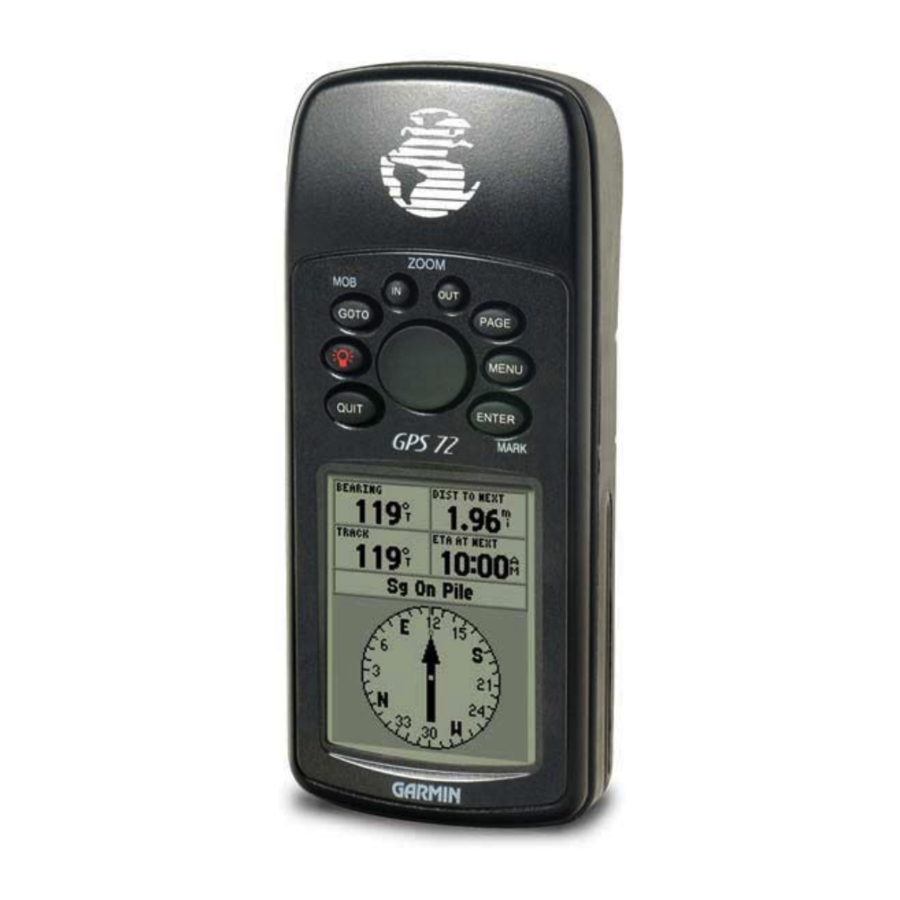
Page 6: Features
The GPS 72 has nine keys located on the front of the unit, that allow the user to Introduction quickly access all of the units functions. The GPS 72 has a large 120 X 160 pixel, 4 level gray monochrome display for easy viewing. -
Page 7: Table Of Contents
Features..........4 Setup Menu-Alarms Tab ..... 46 Table of Contents ....... 5 Setup Menu-Interface Tab... 47 “How To” Index........6 GPS 72 Unit Features ......7 Appendices.........48-65 Section Two: Reference ....7-47 Appendix A: Specifi cations....48 Initializing the GPS Receiver.... 7-8 Appendix B: Wiring &... -
Page 8: Introduction
The list to the right is provided to help you quickly fi nd some of the more important procedures you will use on Points of Interest ......................30 your new GPS 72. Create a route........................ 31 Learn about the GOTO key ................... 36 View celestial information ..................38-40... -
Page 9: Gps 72 Unit Features
Each time the unit is used, the Almanac is updated. This is how the GPS 72 knows which satellites to search for. If you do not use your GPS for several months, or move the unit several hundred miles between uses, the Almanac can become “cold”, that is to say that the orbital information is no longer valid. - Page 10 Initialization Options If the GPS 72 is unable to determine its location, an options menu will be displayed. Introduction Reference Depending on the situation, select an option to help the unit acquire satellites. To select an option, place the highlight over the option then press ENTER.
-
Page 11: Gps Information Page
Indicates that the GPS receiver has lost satellite reception. Simulating GPS — Indicates the GPS 72 is running in Simulator Mode and the GPS receiver is turned off. It is important to remember when you are using the Simulator, the GPS 72 can not be used for actual navigation. - Page 12 Satellite Location The location of each available satellite is displayed over two location rings. The outer Introduction Reference ring represents the horizon, the inner ring represents 45° above the horizon and the center represents directly overhead. When the unit is using a satellite for navigation, the satellite GPS Information Page number will become highlighted on the location rings.
- Page 13 GPS Information Page Options Menu To activate the Options Menu, from the GPS Information Page press the MENU Key. Introduction Reference To select an option, highlight the desired selection then press ENTER. Start/Stop Simulator — This option is used to Start or Stop the Simulator. GPS Information Page This option determines if the satellites are displayed with North Track Up/North Up —...
-
Page 14: Map Page
Map Page The GPS 72 comes with a factory-loaded marine point database that includes marine Introduction Reference navaids and major cities. This can be replaced with marine navaids, cities, and points of interest using GARMIN MapSource products. Map Page Changing the Zoom Scale You can change the Zoom Scale on the Map Page allowing you to view a smaller area in greater detail or a larger area with less detail. - Page 15 Setup Page Layout — This option allows you to select the number of data fi elds rows and the size of text used in the fi elds. You have the option of displaying Small (1 Row), Introduction Reference Small (2 Rows), Small (3 Rows), Large (1 Row), or Large (2 Rows). To select an option, highlight the desired selection then press ENTER.
- Page 16 If you select ‘Off’, the items for that option will not be displayed on the Map Page. If Map Page Options you select ‘Auto’, the GPS 72 will automatically determine the zoom level at which to display the selected items. If you select a scale setting, the items will be displayed on the map only when the Map Zoom Scale is at or less than the selected scale .
- Page 17 Setup Map — ‘Map’ Tab The ‘Map’ Tab contains settings for the Basemap, MapSource, Lat Lon Introduction Reference Grids, and Grid Labels. To change a setting, highlight the appropriate fi eld then press ENTER. Make your new selection then press ENTER to accept the selection. Map Page Options This option allows you to turn map data displayed on the map ‘On’...
- Page 18 Active Route Waypoint — This option sets the display parameters for waypoints that are in an Active Route. As an example, if you have selected ‘Small’ as the text option for all Introduction Reference waypoints, but selected ‘Large’ as the setting for Active Route Waypoints, the waypoints included in an Active Route will be displayed with large text on the Map Page.
- Page 19 Saved Tracks — are Track Logs that have been saved in the units memory. Course Line — controls the display of the Route Line and Go To Line. Introduction Reference The Bearing Line will show the bearing from your current location to Bearing Line —...
-
Page 20: Pointer Page
Pointer Page The Pointer Page is best used for navigation when a straight line course can not be fol- Introduction Reference lowed. The Pointer Page has User Selectable Data Fields along the top, a Active Waypoint Field, Compass Ring and a Pointer. Pointer Page The Compass Ring is a graphic display of your current track. -
Page 21: Highway Page
Highway Page The Highway Page is best used for navigation when a straight line course can be fol- Introduction Reference lowed. The Highway Page has User Selectable Data Fields along the top, a Status Bar, and the Highway Display. The Highway Page shares many features with the Map Page. Any tracks, saved tracks Highway Page or waypoints that are within the display area will be shown, the Zoom Level can be changed using the IN and OUT keys, and the triangle represents your current location. - Page 22 Setup Highway — This option contains the Highway Setup features. The features are arranged on a tab menu making it easy to locate the different setup items. To select an Introduction Reference option from a Menu Tab, highlight the desired selection then press ENTER. Setup Highway —...
-
Page 23: Main Menu Page
Main Menu Page The Main Menu Page contains settings and features that are not on the Main Introduction Reference Pages. The Main Menu can be accessed from any of the Main Pages by pressing MENU twice. Main Menu Page To select an item on the Main Menu, place the highlight over the menu item Trip Computer then press ENTER. -
Page 24: Trip Computer
Total Time — The Total Time fi eld will display the Total Time that the unit has been turned on since the Trip Computer was last reset. Introduction Reference Max Speed — The Maximum Speed fi eld will display the maximum speed the unit traveled since the Max Speed was last reset. -
Page 25: Tracks
Tracks The Tracks Page displays the amount of Track Memory used, will allow you to ‘Save’ or Introduction Reference ‘Clear’ the current Track Log, and displays a list of any Saved Tracks. When you select ‘Save’ you can choose how far back in the log you wish to Save —... - Page 26 Name — this fi eld will allow you to change the Saved Track Name. When tracks are saved the GPS 72 will use a date as the default track name. Distance — shows the total distance of the Saved Track.
-
Page 27: Waypoints
fi eld or scrolling through the Waypoint List. As you enter a waypoint name, the GPS 72 will update the waypoint list to show waypoint names that coincide with the letters that have been entered. You can con-... -
Page 28: Creating Waypoints
Creating Waypoints There are three methods for creating waypoints in the GPS 72. Introduction Reference Creating a waypoint using the ENTER/MARK Key — When at a location that you want to save, press and hold ENTER/MARK until the Mark Waypoint Page is displayed. At... -
Page 29: Create Waypoints
Create Waypoint Options Menu There are four options available when creating waypoints. To view these options, Introduction Reference press the MENU key while the Mark Waypoint page is displayed. Average Location — When selected, the Average Waypoint page will be displayed. The Creating Waypoints page has fi... - Page 30 • ‘Use Map’ to project a waypoint — When ‘Use Map’ is selected, the unit will show a map page. Use the ROCKER to move the Map Pointer to the desired reference loca- Introduction Reference tion and then press ENTER. On the Project Location page, enter a new bearing and distance.
-
Page 31: Editing Waypoints
Editing Waypoints You can edit waypoints when they are created or after they have been saved to memory. Introduction Reference There are six items that can be changed, the symbol, name, location, elevation, depth, you can choose whether or not to show the waypoint name on the Map Page. Press the MENU Key twice to display the Main Menu. -
Page 32: Points Of Interest
Points of Interest This option is only available when MapSource CD Points of Interest data is loaded Introduction Reference in the unit. When ‘Points of Interest’ is selected, the Points of Interest Selection Page is displayed. To select an item, highlight the desired selection then press ENTER. After an item is selected, either a list or selection menu will be displayed. -
Page 33: Routes
fi nish, but can contain as many as fi fty. The GPS 72 can store fi fty routes. On the Routes Page you can create ‘New’ routes, determine how many empty routes that you have left, and review a list of existing routes. - Page 34 ENTER to save the waypoint and ENTER a fi nal time to insert it into the route. If you place the Map Pointer on a Map Feature, the GPS 72 will only store that location in the route using the feature name as a reference. These points are not stored in the User Waypoint List.
- Page 35 Naming the Route — the GPS 72 will automatically name the route using the fi rst and last waypoint names as a reference. To change the Route Name, place the highlight Introduction Reference over the Name fi eld then press ENTER. When you have fi nished, press ENTER to save the new name.
- Page 36 2. Place the Map Pointer over a location that is not a Map Feature then press ENTER. The New Waypoint Page will be displayed. Press ENTER to save the new waypoint. Place Introduction Reference the Map Pointer over the route leg that you want to insert the waypoint into, then press ENTER.
-
Page 37: Proximity
Plan Route — To plan a route, enter a Speed, Fuel Flow, Depart Time and Depart Date. Fuel Flow is measured in “units per hour”. It may be necessary to consult your Introduction Reference vehicle’ s Owner’ s Manual for performance specifi cations. The Active Route Page and Route Page display trip-planning information for each leg or the entire route. -
Page 38: "Goto" Navigation
Navigating using the GOTO key The GPS 72 uses waypoints to help you fi nd your way. A waypoint is a location you create. Introduction Reference You can create a waypoint using a selected location on the map, by entering coordinates, or by marking a location while actually there (see page 26 for information on creating “Goto”... - Page 39 • Point of Interest — Highlight ‘Point of Interest’ on the Go To Selection page and press ENTER. This will display a list of catagories that are available. Select a catagory Introduction Reference and press ENTER. A list of choices in that catagory will be displayed, select an item and press ENTER.
-
Page 40: Celestial
Celestial The Celestial Menu lets you view information for Tides, Sun and Moon, or Hunt and Introduction Reference Fish. Main Menu Date Celestial Local Time Station Name Current Time Current Tide Level Night Low Tide Curve MLLW Min Level Station Time Main Menu —... - Page 41 The top of the page will display the date with the tide station below. The top of the chart will show a 24-hour block of local time (LCL) for your position, with the reported Introduction Reference station time (STA) appearing at the bottom. Daylight (light bar) and night (dark bar) will show across the time scale, with the time progressing from left to right.
-
Page 42: Celestial
Sun and Moon — The Sun and Moon Page displays data for Sunrise/Sunset, Moonrise/ Moonset, and the approximate location of the Sun and Moon on a skyview. The moon Introduction Reference phase will display the current visible portion of the moon in a light shade. You may display this information for your current location or you can use the Map or Points Menu to select a location. -
Page 43: Mapsource Info
Hunt and Fish — The Hunt and Fish Page displays data for Good and Best times for hunting and fi shing at the selected location. There is also a Rating (excellent, good, Introduction Reference normal, poor) displayed, that will refl ect the productivity of the day. You may display this information for your current location or you can use the Map or Points Menu to select a location. -
Page 44: Setup Menu- General Tab
WAAS is an acronym for “Wide Area Augmentation System”. You can use the WAAS capability of the GPS 72 to increase the accuracy to approximately 3 meters. When enabled the GPS receiver searches for a WAAS satellite, then receives data that will help correct differentials in the GPS signal. -
Page 45: Setup Menu-Time Tab
ENTER. Make your selection then press ENTER to activate the selection. ‘ Time Format’ — The GPS 72 can display time in a 12 or 24 hour format. The ‘Time Zone’ setting has nine options, Atlantic, Eastern, Central, ‘ Time Zone’ —... -
Page 46: Setup Menu-Units Tab
Main Menu ‘ Elevation’ — Can be set to show in ‘Feet’ or ‘Meters’. Units & Location Tabs Can be set to display in ‘Feet’, ‘Fathoms’ and ‘Meters’. The GPS 72 cannot ‘ Depth’ — hddd.ddddd° India Zone IVA measure depth on its own. The depth input has to come from a NMEA device provid- hddd°.mm.mmm’... -
Page 47: Location Tab
‘ Map Datum’ — Datums are used to describe geographic positions for surveying, map- ping, and navigation and are not actual maps built in the unit. Although there are over Introduction Reference 100 datums available to choose from, you should only need to change the Map Datum if you using a chart or paper map that specifi... -
Page 48: Setup Menu-Alarms Tab
Setup Menu — ‘ Alarms’ Tab The ‘Alarms’ Tab contains settings for Anchor Drag, Approach and Arrival, Off Course, Introduction Reference Shallow Water, and Deep Water. These settings will determine if, and when a warning beep is sounded and/or a message is displayed. Main Menu ‘... -
Page 49: Setup Menu-Interface Tab
NMEA — seconds. With an NMEA output the GPS 72 to accept NMEA data from another NMEA device, like a echo sounder. selected, press MENU and select The baud (speed of communication in bits per second) is displayed in the Baud fi eld. -
Page 50: Appendices
The temperature rating for the GPS 72 may exceed the usable range of some batteries. Alkaline batteries can rupture at high temperatures. Alkaline batteries lose a signifi cant amount of their capacity as temperature decreases. Use lithium batteries when operating the GPS 72 in below-... -
Page 51: Appendix B: Wiring & Interfacing
Introduction Appendix B The power/data cable connects the GPS 72 to a 8-35 volt DC system and provides interface capabilities for connecting external devices. The color code in the diagram below indicates the appropriate harness connections. Replacement fuse is a AGC/3AG - 2.0 Amp Wiring and Interfacing fuse. -
Page 52: Appendix C: Time Offsets
The chart below gives an approximate UTC ( Universal Time Coordinate) time offset for the various longitudinal zones. Check with local charts for more detailed information. If Introduction Appendix C you are in daylight savings time, add one hour to the offset. Time Offsets Longitudinal Zone Offset... -
Page 53: Appendix D: Map Datums
Adindan Adindan- Ethiopia, Mali, Senegal, Sudan Afgooye Afgooye- Somalia Introduction Appendix D AIN EL ABD ‘70 AIN EL ANBD 1970- Bahrain Island, Saudi Arabia Anna 1 Ast ‘65 Anna 1 Astro ‘65- Cocos I. ARC 1950 ARC 1950- Botswana, Lesotho, Malawi, Swaziland, Zaire, Zambia RC 1960 Kenya, Tanzania Map Datums Ascnsn Isld ‘58... -
Page 54: Appendix D: Map Datums
Oman Oman- Oman Ord Srvy GB Old Survey Grt Britn- England, Isle of Man, Scotland, Shetland Isl., Wales Introduction Appendix D Pico De Las Nv Canary Islands Potsdam Potsdam-Germany Ptcairn Ast ‘67 Pitcairn Astro ‘67- Pitcairn Prov S Am ‘56 Prov So Amricn ‘56- Bolivia, Chile,Colombia, Ecuador, Guyana, Map Datums Peru, Venezuela... -
Page 55: Appendix E: Navigation Terms
Avg Speed— The average of all second-by-second speed readings since last reset. The compass direction from your current location to a destination. Bearing (BRG)— Introduction Appendix E Course— The desired course between the active ‘from’ and ‘to’ waypoints. Distance (Dist)— The ‘great circle’... -
Page 56: Appendix E: Navigation Terms
Odometer— A running tally of distance travelled, based upon the distance between second- by-second position readings. Introduction Appendix E The distance you are off a desired course in either direction, left or right. Also Off Course— referred to as ‘cross-track error’ or ‘course error’. Speed—... -
Page 57: Appendix F: Messages
The water is deeper than the amount set in the Deep Water Alarm. Internal problem with the unit. Contact your dealer or Database Error — GARMIN Customer Service to have the unit repaired. Dragging Anchor — is the message displayed when the distance set in the Anchor Alarm is exceeded. -
Page 58: Appendix F: Messages
Shallow Water — The water is shallower than the amount set in the Shallow Water Alarm. Track Already Exists — A saved track with the same name already exists. Introduction Appendix F Track Memory Full — No more data can be stored without deleting old data. Track Log Full —... -
Page 59: Appendix G: Loran Td
LORAN chain number, change the secondary stations or offsets in the Setup TD fi eld, the active waypoint information will refl ect those changes. Since the GPS 72 does not rely on the LORAN signal for navigation, it can reference a different GRI chain and/or... -
Page 60: Appendix G: Loran Td
The LORAN Position Format fi eld is located under the Units tab in the Main Menu. The ‘LORAN TD Setup’ window contains the fi elds to select the Loran GRI-Chain Number, Introduction Appendix G Primary and Secondary Stations, and TD Offsets. To setup Loran TD from the Main Menu: Loran TD 1. -
Page 61: Appendix H: Accessories
PC Data Cable Allows for serial data transfer with a PC. Cigarette Lighter Adapter Allows the GPS 72 to operate from external auto power. Automotive Mount MapSource Map Data CD-ROMs Enhance the Map Data, create waypoints and routes from your PC. -
Page 62: Appendix I: Index
Battery Saver Mode ..............42 Bearing Line ................17 Introduction Appendix I Beeper ..................43 Index Cautions..................2 Celestial Page ................. 38 Changing Data Fields ............ 13,18,20 Cities..................30 Accessories ................59 Course Line ................17 Accuracy ................. 9 Clearing the Track Log ............23 Accuracy Circle ............... - Page 63 Editing a Route ..............33 Introduction Appendix I Editing Waypoints ..............29 Elevation ................44 Index Estimated Accuracy ..............9 ETA (Estimated Time of Arrival)..........53 Features..................4 IN Key..................12 Follow Track (TrackBack)............24 Initialize the Receiver .............. 7 Full Screen Map ..............
- Page 64 Odometer, Trip................ 22 Introduction Appendix I Off Course Alarm ..............46 Orientation................14 Index Overzoom ................12 Map Page Options ..............12 Plan Route................35 Map Page Setup............... 13 Pointer Page ................18 Map Scales ................12 Pointer Page Options............... 18 Map Zooming................
- Page 65 Route - Creating ..............31-32 Route - Editing ..............33-34 Introduction Appendix I Route - Planning..............35 RTCM ..................47 Satellite Strength ..............10 Saved Tracks ................17 Track Back................24 Setup Menu ..............41-47 Track Log ................16 Shallow Water Alarm ............. 46 Trip Computer ..............
-
Page 66: Appendix J: Warranty
GARMIN (Europe) Ltd. GARMIN retains the exclusive right to repair or replace the unit or software or offer a full refund Unit 4, The Quadrangle, of the purchase price at its sole discretion. SUCH REMEDY SHALL BE YOUR SOLE AND Abbey Park Industrial Estate EXCLUSIVE REMEDY FOR ANY BREACH OF WARRANTY. - Page 67 For the latest free software updates throughout the life of your GARMIN products, visit the GARMIN web site at www.garmin.com. © Copyright 2002 GARMIN Ltd. or its subsidiaries GARMIN International, Inc. 1200 East 151 Street, Olathe, Kansas 66062, U.S.A. GARMIN (Europe) Ltd.
Need help?
Do you have a question about the GPS 72 and is the answer not in the manual?
Questions and answers
How to setup coordinates on a gps 72
To set up coordinates on a Garmin GPS 72, you can create waypoints using one of the following methods:
1. Mark a Location While There: Use the "Mark" button while physically at the location to create a waypoint.
2. Use the Man Overboard (MOB) Function: Press the MOB button to quickly save your current location as a waypoint.
3. Enter Coordinates Manually: You can enter coordinates directly to create a waypoint.
4. Use the Project Method (Trapezoidal Course Setup):
- Go to the reference point.
- Clear existing waypoints (including MOB) by pressing the Menu button twice.
- Add new waypoints using the MOB and Mark buttons for marks 1, 2, 3, and 4.
This method avoids manual coordinate entry and is based on using preset reference points.
This answer is automatically generated