Advertisement
- 1 Getting Started
- 2 Driver Awareness Features and Alerts
- 3 Following a Route
- 4 Using the Map
- 5 Traffic
- 6 Using the Apps
- 7 Settings
- 8 Device Information
- 9 Device Maintenance
- 10 Troubleshooting
- 11 Installing a Memory Card for Maps and Data
- 12 Data Management
- 13 About Memory Cards
- 14 Connecting the Device to Your Computer
- 15 Transferring Data From Your Computer
- 16 Disconnecting the USB Cable
- 17 Viewing GPS Signal Status
- 18 Purchasing Additional Maps
- 19 Purchasing Accessories
- 20 Documents / Resources
Getting Started

See the Important Safety and Product Information guide in the product box for product warnings and other important information.
- Update the maps and software on your device (Map and Software Updates).
- Mount the device in your vehicle and connect it to power (Mounting Considerations).
- Acquire GPS signals (Acquiring GPS Signals).
- Adjust the volume (Adjusting the Volume) and display brightness (Adjusting the Screen Brightness).
- Navigate to your destination (Starting a Route).
Garmin Drive 53 Device Overview

 | Power key |
 | USB power and data port |
 | Map and data memory card slot |
Mounting Considerations
- Do not mount the device in a location that obscures the driver's view of the road.
![]()
It is your responsibility to ensure the mounting location complies with all applicable laws and ordinances, and does not block your view of the road during the safe operation of your vehicle. - Choose a location that allows you to route the power cable safely.
![]()
When installing the device in a vehicle, install the device and power cable securely so they do not interfere with the vehicle operating controls. Interference with the vehicle operating controls can result in a collision, which could result in injury or death. - Choose a location that is within easy reach.
- Thoroughly clean the windshield before installing the mount.
Mounting and Powering the Garmin Drive Device in Your Vehicle
This product contains a lithium-ion battery. To prevent the possibility of personal injury or product damage caused by battery exposure to extreme heat, store the device out of direct sunlight.
Before you use your device on battery power, you should charge it.
- Press the suction cup to the windshield, and flip the lever
![]() back toward the windshield.
back toward the windshield.

 back toward the windshield.
- Press the mount
![]() onto the suction cup ball
onto the suction cup ball ![]() until it snaps into place.
until it snaps into place. - Plug the vehicle power cable into the USB port
![]() on the device.
on the device.

 onto the suction cup ball
  until it snaps into place.
  on the device.
- Plug the other end of the vehicle power cable
![]() into a power outlet in your vehicle.
into a power outlet in your vehicle. - Fit the tab on the top of the mount into the slot on the back of the device, and press the bottom of the mount into the device until it clicks.


Turning the Device On or Off
- To turn the device on, press the power button
![]() , or connect the device to power.
, or connect the device to power.

 , or connect the device to power.
- To put the device in power saving mode, press the power button while the device is on.
While in power saving mode, the screen is off and the device uses very little power, but it can wake instantly for use.
TIP: You can charge your device faster by putting it in power saving mode while charging the battery. - To turn off the device completely, hold the power button until a prompt appears on the screen, and selectOff.
The prompt appears after five seconds. If you release the power button before the prompt appears, the device enters power saving mode.
Acquiring GPS Signals
When you turn on your navigation device, the GPS receiver must collect satellite data and establish the current location. The time required to acquire satellite signals varies based on several factors, including how far you are from the location where you last used your navigation device, whether you have a clear view of the sky, and how long it has been since you last used your navigation device. The first time you turn on your navigation device, it may take several minutes to acquire satellite signals.
- Turn on the device.
- Wait while the device locates satellites.
- If necessary, go to an open area, away from tall buildings and trees.
![]() in the status bar indicates the satellite signal strength. When at least half the bars are filled, the device is ready for navigation.
in the status bar indicates the satellite signal strength. When at least half the bars are filled, the device is ready for navigation.
Status Bar Icons
The status bar is located at the top of the main menu. The status bar icons display information about features on the device. You can select some icons to change settings or view additional information.
 | GPS signal status. Hold to view GPS accuracy and acquired satellite information (Viewing GPS Signal Status). |
 | Current time. Select to set the time (Setting the Time). |
 | Battery charge level. |
Using the On-Screen Buttons
On-screen buttons allow you to navigate the pages, menus, and menu options on your device.
- Select
![]() to return to the previous menu screen.
to return to the previous menu screen. - Hold
![]() to quickly return to the main menu.
to quickly return to the main menu. - Select
![]() or
or ![]() to scroll through lists or menus.
to scroll through lists or menus. - Hold
![]() or
or ![]() to scroll faster.
to scroll faster. - Select
![]() to see a context-based menu of options for the current screen.
to see a context-based menu of options for the current screen.
 to return to the previous menu screen.
 or
or  to scroll through lists or menus.
 to see a context-based menu of options for the current screen.
Adjusting the Volume
- Select Volume.
- Select an option:
- Use the slider bar to adjust the volume.
- Select
![]() to mute the device.
to mute the device. - Select a check box to enable or disable additional sound options.
Using the Audio Mixer
You can use the audio mixer to set the volume levels for different audio types, such as navigation prompts or phone calls. The level for each audio type is a percentage of the master volume.
- Select Volume.
- Select Mixer.
- Use the sliders to adjust the volume for each audio type.
- Getting Started
Enabling or Disabling Sounds and Audio Sources
You can turn specific audio sources and system sounds on or off without affecting other audio sources.
- Select Volume.
- In the Sounds section, select an option:
- To enable the device to speak navigation prompts and directions, select theSpoken Navigation check box.
- To enable the device to speak traffic alerts and prompts, select theSpoken Traffic Alerts check box.
- To enable the device to play a tone when a driver awareness alert is triggered, select theAlerts and Tones check box.
- To enable the device to play a sound when you touch on-screen buttons, select theButton Presses check box.
Adjusting the Screen Brightness
- Select Settings > Display > Brightness.
- Use the slider bar to adjust the brightness.
Driver Awareness Features and Alerts

The driver alerts and speed limit features are for information only and do not replace your responsibility to abide by all posted speed limit signs and to use safe driving judgment at all times. Garmin® is not responsible for any traffic fines or citations you receive for failing to follow all applicable traffic laws and signs.
Your device provides features that can help encourage safer driving and increase efficiency, even when you are driving in a familiar area. The device plays an audible tone or message and displays information for each alert. You can enable or disable the audible tone for some types of driver alerts. Not all alerts are available in all areas.
Schools: The device plays a tone and displays the speed limit (if available) for an upcoming school or school zone.
Speed limit exceeded: The device displays a red border on the speed limit icon when you exceed the posted speed limit for the current road.
Speed limit reduced: The device plays a tone and displays the upcoming speed limit so you can be prepared to adjust your speed.
Wrong way on a one-way street: The device plays a message and displays a full-screen warning if you travel the wrong way on a one-way street. The edges of the screen appear red and an alert remains at the top of the screen until you leave the one-way street or correct your direction of travel.
Railroad crossing: The device displays the distance to an upcoming railroad crossing.
Animal crossing: The device plays a tone to indicate an upcoming animal crossing area.
Curves: The device plays a tone to indicate a bend in the road.
Slower traffic: The device plays a tone to indicate slower traffic when you approach slower traffic at a higher speed. Your device must be receiving traffic information to use this feature (Traffic).
Construction zone: The device plays a tone and displays a message when you approach a construction zone.
Lane closure: The device plays a tone and displays a message when you approach a lane closure.
Break planning: The device plays a tone and suggests upcoming rest stops after you have been driving for a long time.
Enabling or Disabling Driver Alerts
You can enable or disable several types of driver alerts.
- Select Settings > Driver Assistance > Driver Alerts.
- Select or clear the check box next to each alert.
Finding and Saving Locations
The maps loaded in your device contain locations, such as restaurants, hotels, auto services, and detailed street information. The Where To? menu helps you find your destination by providing several methods to browse, search, and save this information.
From the main menu, select Where To?.
- To quickly search all locations on your device, select
![]() Search (Finding a Location Using the Search Bar).
Search (Finding a Location Using the Search Bar). - To find an address, select Address (Finding an Address).
- To browse or search pre-loaded points of interest by category, select Categories (Finding a Location by Category).
- To search near a different city or area, select
![]() next to the current search area (Changing the Search Area).
next to the current search area (Changing the Search Area). - To view and edit your saved locations, selectSaved (Saving Locations).
- To view locations you have recently selected from the search results, select Recent (Viewing Recently Found Locations).
- To browse and search Foursquare® points of interest, select Foursquare® (Searching Foursquare Points of Interest).
- To browse and search Tripadvisor® traveler ratings, select Tripadvisor (Tripadvisor).
- To find national parks and explore park maps, selectNational Parks (Finding National Parks).
- To navigate to specific geographic coordinates, selectCoordinates (Finding a Location Using Coordinates).
Finding a Location Using the Search Bar
You can use the search bar to search for locations by entering a category, brand name, address, or city name.
- Select Where To?.
- Select Search in the search bar.
- Enter all or part of the search term.
Suggested search terms appear below the search bar. - Select an option:
- To search for a type of business, enter a category name (for example, "movie theaters").
- To search for a business name, enter all or part of the name.
- To search for an address near you, enter the house number and street name.
- To search for an address in another city, enter the house number, street name, city, and state.
- To search for a city, enter the city and state.
- To search for coordinates, enter latitude and longitude coordinates.
- Select an option:
- To search using a suggested search term, select the term.
- To search using the text you entered, select
![]() .
.
- If necessary, select a location.
Finding an Address
NOTE: The order of the steps may change depending on the map data loaded on your device.
- Select Where To?.
- If necessary, select
![]() to search near a different city or area.
to search near a different city or area. - Select Address.
- Follow the on-screen instructions to enter address information.
- Select the address.
Location Search Results
By default, the location search results appear in a list, with the nearest location at the top. You can scroll down to view more results.

 | Select a location to view the option menu. |
 | Select to view detailed information about the selected location. |
 | Select to find parking areas near the location. |
 | Select to view alternate routes to the locations. |
 Go! Go! | Select to start navigating to the location using the recommended route. |
 | Select to view the search results on the map. |
Changing the Search Area
By default, the device searches for locations near your current location. You can also search other areas, such as near your destination, near another city, or along your active route.
- Select Where To?.
- Select
![]() next to the current search area
next to the current search area ![]() .
.

- Select a search area.
- If necessary, follow the on-screen instructions to select a specific location.
 next to the current search area
  .
.
The selected search area appears next to ![]() . When you search for a location using any of the options in the Where To? menu, the device suggests locations near this area first.
. When you search for a location using any of the options in the Where To? menu, the device suggests locations near this area first.
Points of Interest
NOTICE
You are responsible for understanding and complying with any applicable rules, laws, or regulations associated with points of interest.
A point of interest is a place that you may find useful or interesting. Points of interest are organized by category and can include popular travel destinations such as gas stations, restaurants, hotels, and entertainment venues.
Finding a Location by Category
- Select Where To?.
- Select a category, or select Categories.
- If necessary, select a subcategory.
- Select a location.
Searching Within a Category
After you have performed a search for a point of interest, certain categories may display a Quick Search list that shows the last four destinations you selected.
- Select Where To? > Categories.
- Select a category.
- Select an option:
- Select a destination from the quick search list on the right side of the screen.
The quick search list provides a list of recently found locations in the selected category. - Select a subcategory, if necessary, and select a destination.
- Select a destination from the quick search list on the right side of the screen.
Finding National Parks
Device models that include maps for North America or the United States also include detailed information for national parks in the United States. You can navigate to a national park or to a location within a national park.
NOTICE
You are responsible for understanding and complying with any applicable rules, laws, or regulations associated with national parks.
- Select Where To? > National Parks.
A list of national parks appears, with the nearest park at the top. - Select Search, and enter all or part of the park name to narrow the results (optional).
- Select a national park.
A list of categories for locations of features and amenities within the park appears below the park name. - Select an option:
- To start navigating to the park, selectGo!.
- To view more park information or explore the park features and amenities, select
![]() .
. - To quickly find a location within the park, select a category from the list below the park name, and select a location.
Foursquare
NOTICE
Garmin is not responsible for the accuracy or timeliness of information provided by Foursquare.
You are responsible for understanding and complying with any applicable rules, laws, or regulations associated with points of interest.
Foursquare is a location-based social network. Your device includes millions of pre-loaded Foursquare points of interest, which are indicated by the Foursquare logo in your location search results.
Searching Foursquare Points of Interest
You can search for Foursquare points of interest loaded on your device.
Select Where To? > Foursquare®.
Viewing Foursquare Location Details
You can view Foursquare location information and user ratings.
- From the location search results, select a Foursquare point of interest.
- Select
![]() .
.
 .
.Tripadvisor
NOTICE
Garmin is not responsible for the accuracy or timeliness of the Tripadvisor information.
You are responsible for understanding and complying with any applicable rules, laws, or regulations associated with points of interest.
Your device includes Tripadvisor traveler ratings. Tripadvisor ratings appear automatically in the search results list for restaurants, hotels, and attractions. You can also search for nearby Tripadvisor points of interest and sort by distance or popularity.
Finding Tripadvisor Points of Interest
- Select Where To? > Tripadvisor.
- Select a category.
- If necessary, select a subcategory.
A list of nearby Tripadvisor points of interest for the category appears. - Select Sort Results to filter the displayed points of interest by distance or popularity (optional).
- Select
![]() , and enter a search term (optional).
, and enter a search term (optional).
Navigating to Points of Interest Within a Venue
NOTE: This feature may not be available in all areas or for all product models.
You can create a route to a point of interest (POI) within a larger venue, such as a store in a shopping mall or a specific terminal in an airport.
- Select Where To? > Search.
- Enter the name of the venue, and select
![]() .
. - Select the venue.
A list of categories for POIs within the venue appears. - Select a category, select a location, and select Go!.
The device creates a route to the parking area or venue entrance closest to the POI. When you arrive at the destination, a checkered flag indicates the recommended parking area. A labeled point indicates the location of the POI within the venue.
Search Tools
Search tools allow you to search for specific types of locations by responding to on-screen prompts.
Finding an Intersection
You can search for an intersection or junction between two streets, highways, or other roads.
- Select Where To? > Intersections.
- Follow the on-screen instructions to enter street information.
- Select the intersection.
Finding a Location Using Coordinates
You can find a location using latitude and longitude coordinates.
- Select Where To? > Coordinates.
- If necessary, select
![]() , and change the coordinate format or datum.
, and change the coordinate format or datum. - Enter the latitude and longitude coordinates.
- Select an option:
- To save the coordinates as a location, select Save.
- To start a route to the coordinates, select Go!.
Parking
Finding Parking Near Your Current Location
- Select Where To? > Categories > Parking.
- Select a parking location.
- Select Go!.
Finding Parking Near a Specified Location
- Select Where To?.
- Search for a location.
- From the location search results, select a location.
- Select
![]() .
.
A list of parking areas near the selected location appears. - Select a parking location.
- Select Go!.
Viewing Recently Found Locations
Your device stores a history of the last 50 locations you have found.
Select Where To? > Recent.
Clearing the List of Recently Found Locations
Select Where To? > Recent >  > Clear > Yes.
Viewing Current Location Information
You can use the Where Am I? page to view information about your current location. This feature is helpful if you need to tell emergency personnel your location.
From the map, select the vehicle.
Finding Emergency Services and Fuel
You can use the Where Am I? page to find the nearest hospitals, police stations, and fuel stations.
- From the map, select the vehicle.
- Select Hospitals, Police Stations, or Fuel.
NOTE: Some service categories are not available in all areas.
A list of locations for the selected service appears, with the nearest locations at the top. - Select a location.
- Select an option:
- To navigate to the location, selectGo!.
- To view the phone number and other location details, select
![]() .
.
Getting Directions to Your Current Location
If you need to tell another person how to get to your current location, your device can give you a list of directions.
- From the map, select the vehicle.
- Select
![]() > Directions to Me.
> Directions to Me. - Select a starting location.
- Select Select.
Adding a Shortcut
You can add shortcuts to the Where To? menu. A shortcut can point to a location, a category, or a search tool.
The Where To? menu can contain up to 36 shortcut icons.
- Select Where To? > Add Shortcut.
- Select an item.
Removing a Shortcut
- Select Where To? >
![]() > Remove Shortcut(s).
> Remove Shortcut(s). - Select a shortcut to remove.
- Select the shortcut again to confirm.
- Select Done.
Saving Locations
Saving a Location
- Search for a location (Finding a Location by Category).
- From the search results, select a location.
- Select
![]() > Save.
> Save. - If necessary, enter a name, and select Done.
- Select Save.
Saving Your Current Location
- From the map, select the vehicle icon.
- Select Save.
- Enter a name, and select Done.
Editing a Saved Location
- Select Where To? > Saved.
- If necessary, select a category.
- Select a location.
- Select
![]() .
. - Select
![]() > Edit.
> Edit. - Select an option:
- SelectName.
- SelectPhone Number.
- SelectCategories to assign categories to the saved location.
- SelectMap Symbol to change the symbol used to mark the saved location on a map.
- Edit the information.
- Select Done.
 .
.Assigning Categories to a Saved Location
You can add custom categories to organize your saved locations.
NOTE: Categories appear in the saved locations menu after you have saved at least 12 locations.
- Select Where To? > Saved.
- Select a location.
- Select
![]() .
. - Select
![]() > Edit > Categories.
> Edit > Categories. - Enter one or more category names, separated by commas.
- If necessary, select a suggested category.
- Select Done.
Deleting a Saved Location
NOTE: Deleted locations cannot be recovered.
- Select Where To? > Saved.
- Select
![]() > Delete.
> Delete. - Select the box next to the saved locations to delete, and select Delete > Yes.
Following a Route
Routes
A route is a path from your current location to one or more destinations.
- The device calculates a recommended route to your destination based on the preferences you set, including the route calculation mode (Changing the Route Calculation Mode, page 16) and avoidances (Avoiding Delays, Tolls, and Areas).
- You can start navigating to your destination quickly using the recommended route, or you can select an alternate route (Starting a Route).
- If there are specific roads you need to use or avoid, you can customize the route.
- You can add multiple destinations to a route (Adding a Location to Your Route).
Starting a Route
- Select Where To?, and search for a location (Finding and Saving Locations).
- Select a location.
- Select an option:
- To start navigating using the recommended route, selectGo!.
- To choose an alternate route, select
![]() , and select a route.
, and select a route.
Alternate routes appear to the right of the map.
The device calculates a route to the location and guides you using voice prompts and information on the map (Your Route on the Map). A preview of the major roads in your route appears at the edge of the map for several seconds.
If you need to stop at additional destinations, you can add the locations to your route (Adding a Location to Your Route).
Starting a Route by Using the Map
You can start a route by selecting a location from the map.
- Select View Map.
- Drag and zoom the map to display the area to search.
- Select an option:
- Select a location marker.
- Select a point, such as a street, intersection, or address location.
- Select Go!.
Going Home
The first time you start a route home, the device prompts you to enter your home location.
- Select Where To? > Go Home.
- If necessary, enter your home location.
Editing Your Home Location
- Select Where To? >
![]() > Set Home Location.
> Set Home Location. - Enter your home location.
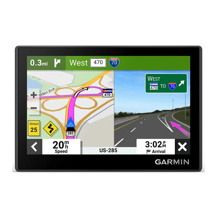
Your Route on the Map
As you travel, the device guides you to your destination using voice prompts and information on the map.
Instructions for your next turn or exit, or other actions appear across the top of the map.

 | Next action in the route. Indicates the next turn, exit, or other action and the lane in which you should travel, if available. |
 | Distance to the next action. |
 | Name of the street or exit associated with the next action. |
 | Route highlighted on the map. |
 | Next action in the route. Arrows on the map indicate the location of upcoming actions. |
 | Vehicle speed. |
 | Name of the road on which you are traveling. |
 | Estimated arrival time. TIP: You can touch this field to change the information it shows (Changing the Map Data Field). |
 | Map tools. Provides tools to show you more information about your route and surroundings. |
Viewing Turns and Directions
While navigating a route, you can view upcoming turns, lane changes, or other directions for your route.
- From the map, select an option:
- To view upcoming turns and directions as you navigate, select
![]() > Turns.
> Turns.
The map tool displays the next several turns or directions beside the map. The list updates automatically as you navigate the route. - To view the complete list of turns and directions for the entire route, select the text bar at the top of the map.
- To view upcoming turns and directions as you navigate, select
- Select a turn or direction (optional).
Detailed information appears. An image of the junction may appear for junctions on major roadways, if available.
Viewing the Entire Route on the Map
- While navigating a route, select anywhere on the map.
- Select
![]() .
.
 .
.Arriving at Your Destination
When you approach your destination, the device provides information to help you complete your route.
![]() indicates the location of your destination on the map, and a voice prompt announces you are approaching your destination.
indicates the location of your destination on the map, and a voice prompt announces you are approaching your destination.- When you stop at your destination, the device automatically ends the route. If the device does not detect your arrival automatically, you can select
![]() > Stop to end your route.
> Stop to end your route.
Parking Near Your Destination
Your device can help you find a parking spot near your destination. When you approach some destinations, the device automatically suggests parking areas.
- Select an option:
- When the device suggests parking, selectMore to see all suggested parking areas.
NOTE: When you select a suggested parking area, the device automatically updates your route. - If the device does not suggest parking locations, selectWhere To? > Categories > Parking, and select
![]() > My Destination.
> My Destination.
- When the device suggests parking, selectMore to see all suggested parking areas.
- Select a parking location, and select Go!.
The device guides you to the parking area.
Changing Your Active Route
Adding a Location to Your Route
Before you can add a location to your route, you must be navigating a route (Starting a Route).
You can add locations to the middle or end of your route. For example, you can add a fuel station as the next destination in your route.
TIP: To create complex routes with multiple destinations or scheduled stops, you can use the route planner to plan, schedule, and save a route (Planning a Route).
- From the map, select
![]() > Where To?.
> Where To?. - Search for a location (Finding and Saving Locations.
- Select a location.
- Select Go!.
- Select an option:
- To add the location as the next destination in your route, selectAdd As Next Stop.
- To add the location to the end of your route, selectAdd As Last Stop.
- To add the location and edit the order of destinations in your route, selectAdd to Active Route.
The device re-calculates the route to include the added location and guides you to the destinations in order.
Shaping Your Route
Before you can shape your route, you must start a route (Starting a Route).
You can manually shape your route to change its course. This allows you to direct the route to use a certain road or go through a certain area without adding a destination to the route.
- Touch anywhere on the map.
- Select Shape Route.
TIP: You can select![]() to zoom in on the map and select a more precise location.
to zoom in on the map and select a more precise location.
The device enters route shaping mode and recalculates the route to travel through the selected location. - Select Go!.
- If necessary, select an option:
- To add more shaping points to the route, select additional locations on the map.
- To remove a shaping point, select the shaping point and select Remove.
Taking a Detour
You can take a detour for a specified distance along your route or detour around specific roads. This is useful if you encounter construction zones, closed roads, or poor road conditions.
- From the map, select
![]() > Edit Route.
> Edit Route. - Select an option:
- To detour your route for a specific distance, selectDetour by Distance.
- To detour around a specific road on the route, selectDetour by Road.
Changing the Route Calculation Mode
- Select Settings > Navigation > Calculation Mode.
- Select an option:
- SelectFaster Time to calculate routes that are faster to drive but can be longer in distance.
- SelectStraight Line to calculate point-to-point routes (without roads).
Stopping the Route
From the map, select ![]() > Stop.
> Stop.
Avoiding Delays, Tolls, and Areas
Avoiding Traffic Delays on Your Route
Before you can avoid traffic delays, you must be receiving traffic information (Receiving Traffic Data Using a Traffic Receiver).
By default, the device optimizes your route to avoid traffic delays automatically. If you have disabled this option in the traffic settings (Traffic Settings), you can view and avoid traffic delays manually.
- While navigating a route, select
![]() > Traffic.
> Traffic. - Select Alternate Route, if available.
- Select Go!.
Avoiding Toll Roads
Your device can avoid routing you through areas that require tolls, such as toll roads, toll bridges, or congestion areas. The device may still include a toll area in your route if no other reasonable routes are available.
- Select Settings > Navigation > Avoidances > Tolls and Fees.
- Select Save.
Avoiding Road Features
- Select Settings > Navigation > Avoidances.
- Select the road features to avoid on your routes, and select Save.
Custom Avoidances
Custom avoidances allow you to select specific areas or sections of road to avoid. When the device calculates a route, it avoids these areas and roads unless no other reasonable route is available.
Avoiding a Road
- Select Settings > Navigation > Custom Avoidances.
- If necessary, select Add Avoidance.
- Select Add Avoid Road.
- Select the starting point of the section of road to avoid, and select Next.
- Select the ending point of the road section, and select Next.
- Select Done.
Avoiding an Area
- Select Settings > Navigation > Custom Avoidances.
- If necessary, select Add Avoidance.
- Select Add Avoid Area.
- Select the upper-left corner of the area to avoid, and select Next.
- Select the lower-right corner of the area to avoid, and select Next.
The selected area is shaded on the map. - Select Done.
Disabling a Custom Avoidance
You can disable a custom avoidance without deleting it.
- Select Settings > Navigation > Custom Avoidances.
- Select an avoidance.
- Select
![]() > Disable.
> Disable.
Deleting Custom Avoidances
- Select Settings > Navigation > Custom Avoidances >
![]() .
. - Select an option:
- To delete all custom avoidances, selectSelect All > Delete.
- To delete one custom avoidance, select the avoidance, and selectDelete.
Using the Map
You can use the map to navigate a route (Your Route on the Map) or to view a map of your surroundings when no route is active.
- Select View Map.
- Touch anywhere on the map.
- Select an option:
- Drag the map to pan left, right, up, or down.
- To zoom in or out, select
![]() or.
or. - To switch between North Up, 2D, and 3D views, select
![]() .
. - To open the route planner, select
![]() (Route Planner).
(Route Planner). - To start a route, select a location on the map, and selectGo! (Starting a Route by Using the Map).
Map Tools
Map tools provide quick access to information and device functions while you view the map. When you activate a map tool, it appears in a panel at the edge of the map.
Stop: Stops navigation of the active route.
Edit Route: Allows you to take a detour or skip locations in your route.
Mute Navigation: Mutes the device audio.
Cities Ahead: Shows upcoming cities and services along your active route or along a highway (Cities Ahead).
Up Ahead: Shows upcoming locations along the route or the road on which you are traveling (Up Ahead).
Traffic: Displays traffic conditions along your route or in your area (Viewing Upcoming Traffic). This feature is not available in all areas or for all device models.
Trip Data: Displays customizable trip data, such as speed or mileage (Viewing Trip Data from the Map).
Turns: Displays a list of upcoming turns in your route (Viewing Turns and Directions).
Viewing a Map Tool
- From the map, select
![]() .
. - Select a map tool.
The map tool appears in a panel at the edge of the map. - When you are done using the map tool, select
![]() .
.
Up Ahead
The Up Ahead tool provides information about upcoming locations along your route or the road on which you are traveling. You can view upcoming points of interest by category, such as restaurants, fuel stations, or rest areas.
You can customize the categories that show in the Up Ahead tool.
Viewing Upcoming Locations
- From the map, select
![]() > Up Ahead.
> Up Ahead.
While you are traveling, the map tool shows the next location along your road or route. - Select an option:
- If the map tool shows categories, select a category to view a list of nearby locations in that category.
- If the map tool shows upcoming locations, select a location to view location details or start a route to the location.
Customizing the Up Ahead Categories
You can change the location categories that appear in the Up Ahead tool.
- From the map, select
![]() > Up Ahead.
> Up Ahead. - Select a category.
- Select
![]() .
. - Select an option:
- To move a category up or down in the list, select and drag the arrow next to the category name.
- To change a category, select the category.
- To create a custom category, select a category, selectCustom Search, and enter the name of a business or category.
- Select Save.
Cities Ahead
While you are traveling on a highway or navigating a route that includes a highway, the Cities Ahead tool provides information about upcoming cities along the highway. For each city, the map tool shows the distance to the highway exit and the services available, similar to the information on highway road signs.
Viewing Upcoming Cities and Exit Services
- From the map, select
![]() > Cities Ahead.
> Cities Ahead.
While you are traveling along a highway or an active route, the map tool shows information about upcoming cities and exits. - Select a city.
The device shows a list of points of interest located at the selected city exit, such as fuel stations, lodging, or restaurants. - Select a location, and select Go! to start navigating.
Trip Information
Viewing Trip Data from the Map
From the map, select > Trip Data.
Customizing the Trip Data Fields
- From the map, select
![]() > Trip Data.
> Trip Data. - Select a trip data field.
- Select an option.
The new trip data field appears in the trip data map tool.
Viewing Trip Data
The trip data tool displays your speed and provides statistics about your trip.
From the map, select Speed.
Viewing Your Trip History
Your device keeps a record of the path you have traveled.
- Select Settings > Map Display > Map Layers.
- Select the Travel History check box.
Resetting Trip Information
- From the map, select Speed.
- Select
![]() > Reset Field(s).
> Reset Field(s). - Select an option:
- When not navigating a route, selectSelect All to reset every data field except the speedometer, on the first page.
- SelectReset Overall Data to reset Trip A and total data.
- SelectReset Trip B to reset the odometer.
- SelectReset Max. Speed to reset the maximum speed.
Viewing Upcoming Traffic
NOTICE
Garmin is not responsible for the accuracy or timeliness of the traffic information.
Before you can use this feature, your device must be receiving traffic data (Traffic).
You can view traffic incidents coming up along your route or along the road on which you are traveling.
- While navigating a route, select
![]() > Traffic.
> Traffic.
The nearest upcoming traffic incident appears in a panel on the right side of the map. - Select the traffic incident to view additional details.
Viewing Traffic on the Map
The traffic map shows color-coded traffic flow and delays on nearby roads.
- From the main menu, select Apps > Traffic.
- If necessary, select
![]() > Legend to view the legend for the traffic map.
> Legend to view the legend for the traffic map.
Searching for Traffic Incidents
- From the main menu, select Apps > Traffic.
- Select
![]() > Incidents.
> Incidents. - Select an item in the list.
- If there is more than one incident, use the arrows to view additional incidents.
Customizing the Map
Customizing the Map Layers
You can customize which data appear on the map, such as topographic maps and BirdsEye imagery.
- Select Settings > Map Display > Map Layers.
- Select the check box next to each layer you want to show on the map.
Changing the Map Data Field
- From the map, select a data field.
NOTE: You cannot customize Speed. - Select a type of data to display.
Changing the Map Perspective
- Select Settings > Map Display > Driving Map View.
- Select an option:
- SelectTrack Up to display the map in two dimensions (2-D), with your direction of travel at the top.
- SelectNorth Up to display the map in 2-D with north at the top.
- Select3-D to display the map in three dimensions.
Traffic
NOTICE
Garmin is not responsible for the accuracy or timeliness of the traffic information.
Your device can provide information about traffic on the road ahead or on your route. You can set your device to avoid traffic when calculating routes, and to find a new route to your destination if a large traffic delay occurs on your active route (Traffic Settings). The traffic map allows you to browse the map for traffic delays in your area.
To provide traffic information, your device must be receiving traffic data.
- All product models can receive traffic data using an over-the-air traffic receiver accessory. Go to your product page at garmin.comto find and purchase a compatible traffic receiver accessory.
Traffic data is not available in all areas. For information about traffic coverage areas, go to garmin.com/traffic.
Receiving Traffic Data Using a Traffic Receiver
NOTICE
Heated (metallized) windshields could degrade the performance of the traffic receiver.
A traffic receiver receives traffic data from an over-the-air broadcast signal, where available. To receive overthe-air traffic data, the device must be connected to vehicle power using a traffic-compatible power cable. A traffic receiver is included with some product models (Traffic). If your product model does not include a traffic receiver, you can go to your product page at garmin.com to find and purchase a compatible traffic receiver cable accessory.
Traffic data is not available in all areas. For information about traffic coverage areas, go to garmin.com/traffic.
Connect the device to vehicle power using the traffic compatible power cable (Mounting Considerations).
If your product model includes traffic data, the vehicle power cable included with your device is traffic compatible. If you purchased a traffic receiver cable as an accessory, you should use the accessory cable to connect the device to vehicle power.
When you are within a traffic coverage area, your device can display traffic information and help you avoid traffic delays.
Enabling Traffic
Before you can enable traffic, you must connect your device to a compatible traffic receiver cable (Receiving Traffic Data Using a Traffic Receiver).
You can enable or disable traffic data.
- Select Settings > Traffic.
- Select the Traffic check box.
Viewing Traffic on the Map
The traffic map shows color-coded traffic flow and delays on nearby roads.
- From the main menu, select Apps > Traffic.
- If necessary, select
![]() > Legend to view the legend for the traffic map.
> Legend to view the legend for the traffic map.
Searching for Traffic Incidents
- From the main menu, select Apps > Traffic.
- Select
![]() > Incidents.
> Incidents. - Select an item in the list.
- If there is more than one incident, use the arrows to view additional incidents.
Using the Apps
Viewing the Owner's Manual on Your Device
You can view the complete owner's manual on the device screen in many languages.
- Select Apps > Owner's Manual.
The owner's manual appears in the same language as the software text (Language and Keyboard Settings). - Select
![]() to search the owner's manual (optional).
to search the owner's manual (optional).
Route Planner
You can use the route planner to create and save a route, which you can navigate later. This can be useful for planning a delivery route, a vacation, or a road trip. You can edit a saved route to further customize it, including reordering locations, adding suggested attractions, and adding shaping points.
You can also use the route planner to edit and save your active route.
Planning a Route
A route can include many locations, and it must include at least a starting location and one destination. The starting location is the location from which you plan to start your route. If you start navigating the route from a different location, the device gives you the option to route to your starting location first. For a round trip, the starting location and final destination can be the same.
- Select Apps > Route Planner > Create Route.
- If necessary, select a calculation mode.
NOTE: The Faster Time mode is selected by default. - Select an option to choose a location for your starting point:
- Select a location on the map.
- Select
![]() , and search for a location (Finding a Location Using the Search Bar).
, and search for a location (Finding a Location Using the Search Bar).
- Repeat step 2 to add more locations.
NOTE: The last location you add is the destination. - After you have added all the necessary locations, select
![]() .
.
Editing and Reordering Locations in a Route
- Select Apps > Route Planner.
- Select a saved route.
- Select List.
- Select a location.
- Select an option:
- To move the location up or down, select
![]() , and drag the location to a new position in the route.
, and drag the location to a new position in the route. - To add a new location after the selected location, select
![]() .
. - To remove the location, select
![]() .
.
- To move the location up or down, select
Changing Routing Options for a Route
You can customize how the device calculates your route.
- Select Apps > Route Planner.
- Select a saved route.
- Select
![]() .
. - Select an option:
- To add shaping points to your route, select Shaping, and select at least one location.
- To change the calculation mode for the route, touch a route segment, and select a calculation mode.
Navigating to a Saved Route
- Select Apps > Route Planner.
- Select a saved route.
- Select Go!.
- Select the first location to navigate to, and select OK.
- Select Start.
The device calculates a route from your current location to the selected location, and then it guides you to the remaining route destinations in order.
Editing and Saving Your Active Route
If a route is active, you can use the route planner to edit and save it.
- Select Apps > Route Planner > My Active Route.
- Edit your route using any of the route planner features.
The route recalculates each time you make a change. - Select Save to save your route, which you can navigate again later (optional).
Viewing Previous Routes and Destinations
Before you can use this feature, you must enable the travel history feature (Device and Privacy Settings).
You can view your previous routes and places you have stopped on the map.
Select Apps > Trip History.
Settings
Map and Vehicle Settings
Select Settings > Map Display.
Map Vehicle Icon: Sets the vehicle icon that represents your position on the map.
Driving Map View: Sets the perspective on the map.
Map Detail: Sets the level of detail on the map. More detail may cause the map to draw slower.
Map Theme: Changes the color of the map data.
Map Layers: Sets the data that appears on the map page (Customizing the Map Layers).
myMaps: Sets which installed maps the device uses.
Enabling Maps
You can enable map products installed on your device.
TIP: To purchase additional map products, go to buy.garmin.com.
- Select Settings > Map Display > myMaps.
- Select a map.
Navigation Settings
Select Settings > Navigation.
Calculation Mode: Sets the route calculation method.
Avoidances: Sets road features to avoid on a route.
Custom Avoidances: Allows you to avoid specific roads or areas.
Restricted Mode: Disables all functions that require significant operator attention.
GPS Simulator: Stops the device from receiving a GPS signal, and saves battery power.
Calculation Mode Settings
Select Settings > Navigation > Calculation Mode.
The route calculation is based on road speeds and vehicle acceleration data for a given route.
Faster Time: Calculates routes that are faster to drive but can be longer in distance.
Straight Line: Calculates a direct line from your location to your destination.
Setting a Simulated Location
If you are indoors or not receiving satellite signals, you can use the GPS simulator to plan routes from a simulated location.
- Select Settings > Navigation > GPS Simulator.
- From the main menu, select View Map.
- Tap the map twice to select an area.
The address of the location appears at the bottom of the screen. - Select the location description.
- Select Set Location.
Driver Assistance Settings
Select Settings > Driver Assistance.
Driver Alerts: Allows you to enable or disable alerts for upcoming zones or road conditions (Driver Awareness Features and Alerts).
Speeding Alert: Alerts you when you are exceeding the speed limit.
Reduced Speed Tone: Alerts you when the speed limit decreases.
Route Preview: Shows a preview of the major roads in your route when you start navigation.
Proximity Alerts: Alerts you when you approach speed cameras or red light cameras.
Proximity Alerts Settings
NOTE: You must have custom points of interest (POIs) loaded for proximity points alerts to display.
NOTE: This feature is not available in all areas.
Select Settings > Driver Assistance > Proximity Alerts.
Audio: Sets the style of alert that plays when you approach proximity points.
Alerts: Sets the type of proximity points for which alerts are played.
Display Settings
Select Settings > Display.
Color Mode: Allows you to select day or night color mode. If you select the Auto option, the device automatically switches to day or night colors based on the time of day.
Brightness: Allows you to adjust the display brightness.
Display Timeout: Allows you to set the amount of idle time before your device enters sleep mode while using battery power.
Screenshot: Allows you to take a picture of the device screen. Screenshots are saved in the Screenshot folder of the device storage.
Traffic Settings
From the main menu, select Settings > Traffic.
Traffic: Enables the traffic feature.
Units and Time Settings
To open the Units and Time settings page, from the main menu, select Settings > Units & Time.
Current Time: Sets the device time.
Time Format: Allows you to select a 12-hour, 24-hour, or UTC display time.
Units: Sets the unit of measure used for distances.
Position Format: Sets the coordinate format and datum used for geographical coordinates.
Setting the Time
- From the main menu, select the time.
- Select an option:
- To set the time automatically using GPS information, selectAutomatic.
- To set the time manually, drag the numbers up or down.
Language and Keyboard Settings
To open the Language and Keyboard settings, from the main menu, select Settings > Language & Keyboard.
Voice Language: Sets the language for voice prompts.
Text Language: Sets all on-screen text to the selected language.
NOTE: Changing the text language does not change the language of user-entered data or map data, such as street names.
Keyboard Language: Enables keyboard languages.
Device and Privacy Settings
Select Settings > Device.
About: Displays the software version number, the unit ID number, and information on several other software features.
Regulatory: Displays regulatory markings and information.
EULAs: Displays the end-user license agreements.
NOTE: You need this information when you update the system software or purchase additional map data.
Software Licenses: Displays software licensing information.
Travel History: Allows the device to store a record of the places you go. This allows you to view the trip log, use the Trip History feature, and use myTrends™ suggested routes.
Reset: Allows you to clear your travel history, reset settings, or delete all user data.
Resetting Data and Settings
The device offers several options for deleting your user data and resetting all settings to the factory default values.
- Select Settings > Device > Reset.
- Select an option:
- To clear your travel history, selectClear Travel History.
This option deletes all records of the places you have traveled. It does not delete saved locations or installed maps. - To reset all settings to the factory default values, selectReset Default Settings.
This option does not delete any user data. - To delete all user data and reset all settings to the factory default values, selectDelete Data and Reset Settings.
This option deletes all user data, including your saved locations, recently found locations, and travel history. Installed maps are not deleted.
- To clear your travel history, selectClear Travel History.
Device Information
Viewing E-label Regulatory and Compliance Information
- From the settings menu, swipe to the bottom of the menu.
- Select Device > Regulatory.
Specifications
| Operating temperature range | From -20° to 55°C (from -4° to 131°F) |
| Charging temperature range | From 0° to 45°C (from 32° to 113°F) |
| Wireless frequency and transmit power | 2.4 GHz @ 18.4 dBm maximum |
| EU SAR | 0.13 W/kg torso, 0.35 W/kg limb |
| Power input | Vehicle power using the included vehicle power cable. AC power using an optional accessory (for home and office use only). |
| Battery type | Rechargeable lithium-ion |
Charging the Device
NOTE: This Class III product shall be powered by an LPS power supply.
You can charge the battery in the device using any of these methods.
- Connect the device to vehicle power.
- Connect the device to an optional power adapter accessory, such as a wall power adapter.
You can purchase an approved Garmin AC-DC adapter suitable for home or office use from a Garmin dealer or www.garmin.com. The device may charge slowly when connected to a third-party adapter.
Device Maintenance
Garmin Support Center
Go to support.garmin.com for help and information, such as product manuals, frequently asked questions, videos, and customer support.
Map and Software Updates
For the best navigation experience, you should keep the maps and software on your device up to date.
Map updates provide the newest available changes to roads and locations in the maps used by your device.
Keeping maps up to date helps your device find recently added locations and calculate more accurate routes. Map updates are large and may take several hours to complete.
Software updates provide changes and improvements to the device features and operation.
Updating Maps and Software with Garmin Express™
You can use the Garmin Express application to download and install the latest map and software updates for your device.
- If you do not have the Garmin Express application installed on your computer, go to garmin.com/express and follow the on-screen instructions to install it (Installing Garmin Express).
- Open the
![]() Garmin Express application.
Garmin Express application. - Connect your device to your computer using a USB cable.
The small end of the cable connects to the USB port![]() on your Garmin Drive device, and the large end connects to an available USB port on your computer.
on your Garmin Drive device, and the large end connects to an available USB port on your computer.

- From your Garmin Drive device, select Tap to Connect to Computer.
- When your Garmin Drive device prompts you to enter file transfer mode, select Continue.
- In the Garmin Express application, click Add a Device.
The Garmin Express application searches for your device and displays the device name and serial number. - Click Add Device, and follow the on-screen instructions to add your device to the Garmin Express application.
When setup is complete, the Garmin Express application displays the updates available for your device.

- Select an option:
- To install all available updates, clickInstall All.
- To install a specific update, clickView Details, and click Install next to the update you want.
The Garmin Express application downloads and installs the updates onto your device. Map updates are very large, and this process may take a long time on slower internet connections.
NOTE: If a map update is too large for the internal storage of the device, the software may prompt you to install a microSD® card in your device to add storage space (Installing a Memory Card for Maps and Data).
- Follow the on-screen instructions during the update process to finish installing updates.
For example, during the update process, the Garmin Express application may instruct you to disconnect and reconnect your device.


Installing Garmin Express
The Garmin Express application is available for Windows® and Mac® computers.
- On your computer, go to garmin.com/express.
- Select an option:
- To view the system requirements and verify the Garmin Express application is compatible with your computer, select System Requirements.
- To install on a Windows computer, select Download for Windows.
- To install on a Mac computer, select Download for Mac.
- Open the downloaded file, and follow the on-screen instructions to complete the installation.
Device Care
NOTICE
Avoid dropping your device.
Do not store the device where prolonged exposure to extreme temperatures can occur, because it can cause permanent damage.
Never use a hard or sharp object to operate the touchscreen, or damage may result.
Do not expose the device to water.
Cleaning the Outer Casing
NOTICE
Avoid chemical cleaners and solvents that can damage plastic components.
- Clean the outer casing of the device (not the touchscreen) using a cloth dampened with a mild detergent solution.
- Wipe the device dry.
Cleaning the Touchscreen
- Use a soft, clean, lint-free cloth.
- If necessary, lightly dampen the cloth with water.
- If using a dampened cloth, turn off the device and disconnect the device from power.
- Gently wipe the screen with the cloth.
Avoiding Theft
- Remove the device and mount from sight when not in use.
- Remove the residue left on the windshield by the suction cup.
- Do not keep your unit in the glove compartment.
- Register your device using the Garmin Express software (garmin.com/express).
Restarting the Device
You can restart your device if it stops functioning.
Hold the power button for 12 seconds.
Removing the Device, Mount, and Suction Cup
Removing the Device from the Mount
- Press the release tab or button on the mount.
- Tilt the bottom of the device upward, and lift the device from the mount.
Removing the Mount from the Suction Cup
- If necessary loosen the nut that secures the mount to the suction cup ball.
- Turn the device mount to the right or left.
- Apply pressure until the socket on the mount releases the ball on the suction cup.
Removing the Suction Cup from the Windshield
- Flip the lever on the suction cup toward you.
- Pull the tab on the suction cup toward you.
Troubleshooting
I cannot adjust the screen brightness on my device
If your Garmin Drive device is not supplied with enough power, the screen does not display at full brightness.
- Verify your vehicle is turned on and is supplying power to the power outlet.
- Verify the Garmin Drive device is connected to vehicle power using the included vehicle power cable and the included vehicle power adapter (Mounting Considerations).
The suction cup will not stay on my windshield
- Clean the suction cup and windshield with rubbing alcohol.
- Dry with a clean, dry cloth.
- Mount the suction cup (Mounting Considerations).
My device is not acquiring satellite signals
- Verify the GPS simulator is turned off (Navigation Settings).
- Take your device out of parking garages and away from tall buildings and trees.
- Remain stationary for several minutes.
My battery does not stay charged for very long
- Decrease the screen brightness (Display Settings).
- Shorten the display timeout (Display Settings).
- Decrease the volume (Adjusting the Volume).
- Put the device in power saving mode when not in use (Turning the Device On or Off,).
- Keep your device away from extreme temperatures.
- Do not leave your device in direct sunlight.
Installing a Memory Card for Maps and Data
You can install a memory card to increase the storage space for maps and other data on your device. You can purchase memory cards from an electronics supplier. The device supports microSD memory cards from 4 to 256 GB. Memory cards must use the FAT32 file system format. Memory cards greater than 32 GB must be formatted using the device.
- Locate the map and data memory card slot on your device (Garmin Drive 53 Device Overview).
- Insert a memory card into the slot.
- Press it in until it clicks.
Data Management
The device has a memory card slot for additional data storage.
NOTE: The device is compatible with Windows 7 and newer, and Mac OS 10.7 and newer.
About Memory Cards
You can purchase memory cards from an electronics supplier, or purchase pre-loaded Garmin mapping software (www.garmin.com).
Memory cards can be used to store files such as maps and custom POIs.
Connecting the Device to Your Computer
You can connect the device to your computer using a USB cable.
- Plug the small end of the USB cable into the port on the device.
- Plug the larger end of the USB cable into a port on your computer.
- From your Garmin Drive device, select Tap to Connect to Computer.
- When your Garmin Drive device prompts you to enter file transfer mode, select Continue.
A picture of your device connected to a computer appears on the device screen.
Depending on your computer operating system, the device appears as either a portable device, a removable drive, or a removable volume.
Transferring Data From Your Computer
- Connect the device to your computer (Connecting the Device to Your Computer).
Depending on your computer operating system, the device appears as either a portable device, a removable drive, or a removable volume. - On your computer, open the file browser.
- Select a file.
- Select Edit > Copy.
- Browse to a folder on the device.
NOTE: For a removable drive or volume, you should not place files in the Garmin folder. - Select Edit > Paste.
Disconnecting the USB Cable
If your device is connected to your computer as a removable drive or volume, you must safely disconnect your device from your computer to avoid data loss. If your device is connected to your Windows computer as a portable device, it is not necessary to safely disconnect the device.
- Complete an action:
- For Windows computers, select theSafely Remove Hardware icon in the system tray, and select your device.
- For Apple® computers, select the device, and select File > Eject.
- Disconnect the cable from your computer.
Viewing GPS Signal Status
Hold ![]() for three seconds.
for three seconds.
Purchasing Additional Maps
- Go to your device product page at garmin.com.
- Click the Maps tab.
- Follow the on-screen instructions.
Purchasing Accessories
- Optional accessories are available at garmin.com or from your Garmin dealer.
Documents / Resources
References
![garmin.com]() Officiële Garmin website | Nederland
Officiële Garmin website | Nederland![garmin.com]() Garmin live traffic | Garmin
Garmin live traffic | Garmin![buy.garmin.com]() Officiële Garmin website | Nederland
Officiële Garmin website | Nederland![www.garmin.com]() Officiële Garmin website | Nederland
Officiële Garmin website | Nederland![support.garmin.com]() Garmin | Nederland | Support
Garmin | Nederland | Support![www.garmin.com]() Garmin Express - Windows | Garmin
Garmin Express - Windows | Garmin![garmin.com]() Garmin Express - Windows | Garmin
Garmin Express - Windows | Garmin
Download manual
Here you can download full pdf version of manual, it may contain additional safety instructions, warranty information, FCC rules, etc.
Advertisement


Need help?
Do you have a question about the DRIVE 53 and is the answer not in the manual?
Questions and answers