Table of Contents
Advertisement
Advertisement
Table of Contents

Related Manuals for CHCNAV CHC X900U+ GNSS


Summary of Contents for CHCNAV CHC X900U+ GNSS
- Page 1 FCC ID: SY4-A01024 ® X900U+ GNSS Receiver User Guide...
- Page 2 Revision 1.0 June 10, 2018...
-
Page 3: Table Of Contents
Table of Content Table of Content Table of Content....................3 Preface ......................... 5 Copyright ........................ 5 Safety Warnings ..................... 5 FCC Interference Statement ................... 5 CE Interference Statement ..................6 Introduction ....................7 Safety Information ..................7 1.1.1 Warnings and Cautions ..............7 1.1.2 Regulations and Safety ............... - Page 4 Base Shift ....................25 Data Export ....................25 Receiver Registration ................26...
-
Page 5: Preface
Preface Preface Copyright Copyright 2014-2015 CHC | Shanghai Huace Navigation Technology Ltd. All rights reserved. The CHC is a trademark of Shanghai Huace Navigation Technology Limited. All other trademarks are the property of their respective owners. Trademarks All product and brand names mentioned in this publication are trademarks of their respective holders. -
Page 6: Ce Interference Statement
Preface CE Interference Statement Declaration of Conformity: Hereby, Shanghai Huace Navigation Technology Ltd. declares that this X900U+ is in compliance with the essential requirements and other relevant provisions of Directive 2014/53/EU. A copy of the Declaration of conformity can be found at Shanghai Huace Navigation Technology Ltd. -
Page 7: Introduction
Even if user has used other Global Navigation Satellite Systems (GNSS) products before, CHC recommends user spend some time reading this manual to learn about the special features of this product. If user is not familiar with GNSS, go to www.chcnav.com an interactive look at CHC and GNSS. 1.1 Safety Information 1.1.1 Warnings and Cautions... -
Page 8: Use And Care
1.2 Technical Support If user has a problem and cannot find the information user needs in this manual or CHC website (www.chcnav.com), contact user’s local CHC dealer from which user purchased the receiver(s). If the user needs to contact CHC technical support, please contact us by email (support@chcnav.com) or Skype (chc_support). -
Page 9: Getting Started With X900U
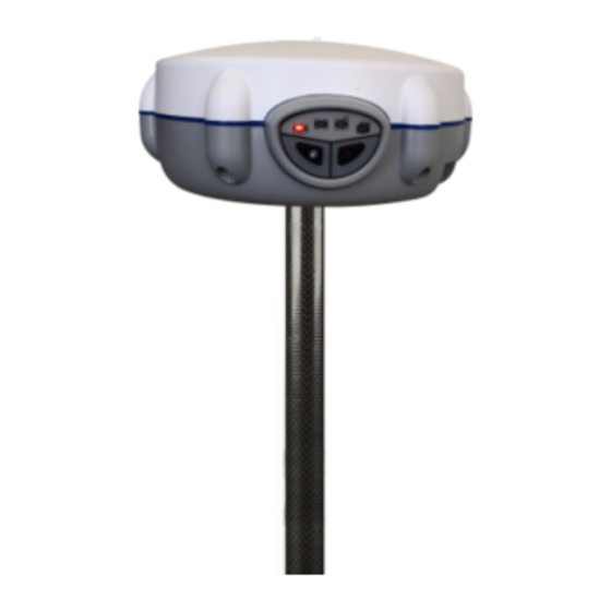
Getting Started with X900U+ 2 Getting Started with X900U+ 2.1 About the Receiver X900U+ GPS+GLONASS+BDS+Galileo system is designed to enable every surveyor to access to high precision, robust performances and reliable technology but without the typical price constraints usually associated with GNSS investment. X900U+ GPS matches a wide range of applications requiring static positioning. - Page 10 Getting Started with X900U+ Satellite LED Correction LED Static LED Power LED Function button Power button Name Description Shows the power status of the receiver. Power LED (Red) • When the receiver is powered on, the red LED lights Shows the number of satellites that the receiver has tracked.
-
Page 11: Lower Housing
Getting Started with X900U+ 2.2.2 Lower Housing The lower housing contains one SIM card slot(canceled), battery compartments, one communication and power ports, one GPRS antenna connector, one TNC radio radio antenna connector, one 5/8-11 threaded insert, and two nameplates. 2.2.3 Receiver Ports Name Description •... - Page 12 Getting Started with X900U+ completely before using it for the first time. To charge the battery, first, remove the battery from the receiver, and then place it in the battery charger, which is connected to AC power. WARNING - Charge and use the rechargeable Lithium-ion battery only in strict accordance with the instructions.
-
Page 13: External Power Supply
Getting Started with X900U+ (2) If battery fluid gets into user’s eyes, immediately rinses user’s eyes with clean water and seek medical attention. Please do not rub user’s eyes! (3) If battery fluid gets on user’s skin or clothing, immediately wash them off under running water. - Page 14 Getting Started with X900U+ X900U+ GNSS Receiver GPS to PC Cable Lithium Battery C300 Battery Charger H.I. Tape Extension Pole Tribrach with Optical Plummet Tribrach Adaptor...
- Page 15 Getting Started with X900U+ Transport Hard Case...
-
Page 16: Connecting To Controller With Landstar 7
Getting Started with X900U+ 2.5 Connecting to Controller with LandStar 7 This section uses Smartphone as the example to show how to connect the receiver to the controller using LandStar 7 via Bluetooth. Turn on the receiver → Launch LandStar 7 → press config on the bottom of the screen →... -
Page 17: Downloading Logged Data
Getting Started with X900U+ (4) After the processing completes, please close the uploader, and then power off and power on the receiver again. (5) Now, the whole update has been finished successfully. 2.7 Downloading Logged Data Data logging involves the collection of GNSS measurement data over a period at a static point or points, and subsequent post-processing of the information to accurately compute baseline information. - Page 18 Getting Started with X900U+ Notes: For hcn files, the name of the file is represented as XXXXXXDDDNN, where XXXXXX is the SN of the receiver, DDD is day of year, and NN is the recording session. WARNING – The static data will be saved in the first logging session, the “record_1”...
-
Page 19: Rover Station Setup And Operation
The system needs at least five common satellites to provide RTK positioning. WARNING – Do not touch overhead power lines with the CHC X900U+ GNSS receiver or the range pole when moving the equipment into position. Touching overhead power lines may cause electrocution, leading to serious injury. -
Page 20: Configuring The Rover Station Via Landstar 7 Software
3.2 Configuring the Rover Station via LandStar 7 Software 3.2.1 Receiving Static Data (1) Power on the receiver. (2) Run LandStar 7 on the controller → create a new project or open an existing project → establish the connection with the receiver via Bluetooth. (3) On the Static Setting screen, set parameters as need and then click Set to finish. -
Page 21: Survey With Landstar 7 Software
4 Survey with LandStar 7 Software The CHC LandStar 7 Software (“LandStar 7”) is a field survey software which developed based on more than ten years of development experience of CHC and feedback of surveyors from different fields of application. LandStar 7 provides with a complete set of features for any survey projects, including data collection, stakeout, COGO (Coordinate Geometry) function, and more, which makes this software an ideal option for everyday field work. - Page 22 (2) Tap add button in the lower left corner of Points screen, and then configure the related parameters of the new point as follows: Name: Enter the point name. Code: Enter the code of the point, if required. Coordinate Format: Select the coordination format from the dropdown list. There are five available options: Local N/E/H, Local Lat/Lon/H, Local X/Y/Z;...
-
Page 23: Measure Points
WGS84 Lat/Lon/H, WGS84 X/Y/Z. Coordinate: depend on the coordinate format user choose. (3) Tap ok button at the bottom of New point screen to save the point. 4.3 Measure Points Note: To ensure the accuracy of the coordinates measured; please perform measurements after the rover receiver receives correction data (with correction LED flashes once per second) and gets a fixed solution. - Page 24 Notes: • General speaking, if a three- or seven-parameter datum transformation has been configured for the project, users can skip the site calibration and the coordinates measured will be transformed automatically into local grid coordinates. • If a projection and datum transformation have already been specified, users can reduce any discrepancies between the WGS-84 coordinates and the local grid coordinates by performing a site calibration.
- Page 25 4.6 Base Shift Typically, the Real-time kinematic (RTK) operation requires a data link to send observations or corrections from the base station to the rover, and then the rover will calculate its position in real time. Within a project, when the base receiver is restarted or moved, the base coordinated system will shift each time the position of the base station is changed.
- Page 26 requirement. (3) Tick the point type(s) → enter the File Name → select the File Type from the dropdown list → select the path that used to store the file. (4) Tap Export → the software will prompt whether the file has been successfully exported.
- Page 27 CHC - Shanghai Huace Navigation Technology Ltd. 599 Gaojing Road, Building D Shanghai, 201702, China Tel: +86 21 542 60 273 Fax: +86 21 649 50 963 Email: sales@chcnav.com support@chcnav.com Website: www.chcnav.com...
Need help?
Do you have a question about the CHC X900U+ GNSS and is the answer not in the manual?
Questions and answers
Quantas constelações de satélites ele processa?
The CHCNAV X900U+ GNSS processes at least two satellite constellations, such as GPS and GLONASS.
This answer is automatically generated