B&G Zeus2 Operator's Manual
Hide thumbs
Also See for Zeus2:
- Operator's manual (108 pages) ,
- Installation manual (52 pages) ,
- Quick start manual (9 pages)
Table of Contents
Advertisement
Quick Links
Download this manual
See also:
Installation Manual
Advertisement
Table of Contents

Related Manuals for B&G Zeus2


Summary of Contents for B&G Zeus2
- Page 1 Zeus Operator Manual ENGLISH bandg.com...
- Page 3 • DownScan Imaging™ (DownScan) • DownScan Overlay™ (Overlay) • ForwardScan™ (ForwardScan) • GoFree™ (GoFree) • SonicHub® (SonicHub) • StructureMap™ (StructureMap) • StructureScan® (StructureScan) • StructureScan® HD (StructureScan HD) Copyright Copyright © 2015 Navico Holding AS. Preface | Zeus2 Operator Manual...
-
Page 4: About This Manual
Manuals can be downloaded from bandg.com. The manuals can be read from a card inserted in the card reader or copied to the unit’s internal memory. Preface | Zeus2 Operator Manual... - Page 5 The software version currently on this unit can be found in the About dialog. The About dialog is available in the System Settings. For information regarding upgrading your software, refer to "Software upgrades" on page 118. Preface | Zeus2 Operator Manual...
-
Page 6: Table Of Contents
Chart overlay Insight charts Navionics charts Jeppesen charts Chart settings 35 Waypoints, Routes, and Tracks Waypoints Routes Tracks Waypoints, Routes, and Tracks dialogs 40 Navigating Navigate to cursor position Navigate a route Navigating with the autopilot Contents | Zeus2 Operator Manual... - Page 7 Using the cursor on a radar panel Saving waypoints Adjusting the radar image Advanced radar options Radar view options EBL/VRM markers Setting a guard zone around your vessel MARPA targets Recording radar data Radar settings Contents | Zeus2 Operator Manual...
- Page 8 Uploading log files to Insight Genesis Wireless settings 94 AIS AIS target symbols Viewing information about AIS targets Calling an AIS vessel AIS SART Vessel alarms Vessel settings Instrument panels Dashboards Customizing the Instruments panel Contents | Zeus2 Operator Manual...
- Page 9 117 Preventive maintenance 117 Cleaning the display unit 117 Cleaning the media port door 117 Checking the keys 117 Checking the connectors 117 NMEA Data logging 118 Software upgrades 118 Backing up your system data Contents | Zeus2 Operator Manual...
-
Page 10: Introduction
With no active cursor: Press to immediately save a waypoint at vessel position. Press and hold to display the Plot menu used for saving new waypoints, routes and tracks. Card reader door Micro-SD Card readers Ú Note: The MARK key is not available on 7" units. Introduction | Zeus2 Operator Manual... -
Page 11: The Home Page
Select a button to display the panel combination. Press and hold a favorite button to enter edit mode for the Favorites panel. Man Over Board (MOB) button Select to save a Man Over Board (MOB) waypoint at the current vessel position. Introduction | Zeus2 Operator Manual... -
Page 12: Application Pages
Panel sizes in a split page can be adjusted from the System Controls dialog. Pre-configured split pages Each full screen application has several pre-configured split pages, featuring the selected application combined with each of the other panels. Introduction | Zeus2 Operator Manual... -
Page 13: Integration Of 3 Rd Party Devices
The CZone icon is available in the Tools panel on the Home page when a CZone system is available on the network. A separate manual is provided with your CZone system. Refer to this documentation and to the Zeus Installation manual for how to install and configure the CZone system. Introduction | Zeus2 Operator Manual... -
Page 14: H5000 Integration
Installation manual for how to install and configure the H5000 system. Remote controllers You can connect a ZC1 to the network and remotely control the Zeus A separate manual is included with the remote controller. Introduction | Zeus2 Operator Manual... -
Page 15: Basic Operation
You remove the lock function by a short press on the Power key. Touchscreen operation Basic touchscreen operation on the different panels is shown in the table below. The panel sections in this manual have more information about panel specific touchscreen operation. Basic operation | Zeus2 Operator Manual... -
Page 16: Using Menus And Dialogs
Press the knob to select a highlighted item • Turn the knob to adjust the value of a selected item Select the Back menu option or the X key to return to the previous menu level, and then exit. Basic operation | Zeus2 Operator Manual... -
Page 17: Selecting Pages And Panels
Screen capture Simultaneously press the Home and Power keys to take a screen capture. By default, screen captures are saved to internal memory. Refer to "Tools" on page 113 for how to view files. Basic operation | Zeus2 Operator Manual... -
Page 18: Customizing Your System
PIN code must be entered when any of the following are selected. After the correct PIN code is entered, all of them can be accessed without re- entering the PIN code. • Settings, activated from the Tools panel or System Controls dialog Customizing your system | Zeus2 Operator Manual... -
Page 19: Adding New Favorite Pages
You can specify the information displayed in the instrument bars. You can turn the Instrument bar off from the System controls dialog. Ú Note: This only turns the Instrument bar off for the current page. Customizing your system | Zeus2 Operator Manual... - Page 20 You can configure Bar 1 for the active page or for all pages except those that have a local configuration. Bar 2 can only be configured for the active page. Select Menu and then Finish editing to save your changes. Customizing your system | Zeus2 Operator Manual...
-
Page 21: Charts
Ú Note: The system does not automatically switch to embedded cartography if the chart card is removed. A low-resolution chart will be displayed until you re-insert the card or manually switch back to the embedded cartography. Charts | Zeus2 Operator Manual... -
Page 22: Showing Dual Chart Types
If heading is not available, then the COG from the GPS is used. Course up Rotates the chart in the direction of the next waypoint when navigating a route or navigating to a waypoint. If not navigating the heading up orientation is used until navigation is started. Charts | Zeus2 Operator Manual... -
Page 23: Displaying Information About Chart Items
Without removing your finger from the screen, drag the selection circle over the desired item to display item information. When you remove your finger from the screen the cursor reverts to normal cursor operation. Charts | Zeus2 Operator Manual... -
Page 24: Saving Waypoints
You can search for other vessels or various chart items from a chart panel. Activate the cursor on the panel to search from the cursor position. If the cursor is not active, the system searches for items from the vessel's position. Charts | Zeus2 Operator Manual... -
Page 25: 3D Charts
Orientation, Look ahead, 3D, and change Chart source (previously described in this section) are common for all chart types. Chart imagery style The charts can be displayed in three imagery styles. 2D mapping style Shaded relief No contours Charts | Zeus2 Operator Manual... -
Page 26: Navionics Charts
The tide and current data available in Navionics charts are related to a specific date and time. The system animates the arrows and/or gauges to show the tides and currents evolution over time. Charts | Zeus2 Operator Manual... - Page 27 Minimum transparency Maximum transparency Navionics Fish N' Chip The system supports Navionics Fish N' Chip (U.S. only) chart feature. For more information, see www.navionics.com. Charts | Zeus2 Operator Manual...
-
Page 28: Navionics Chart Settings
Determines which contours you see on the chart down to the selected safety depth value. Rock filter level Hides rock identification on the chart beneath a given depth. This helps you to declutter charts in areas where there are many rocks located at depths well below your vessel's draught. Charts | Zeus2 Operator Manual... -
Page 29: Jeppesen Charts
Orientation, Look ahead, 3D, and change Chart source (previously described in this section) are common for all chart types. Presentation The charts can be displayed in different imagery styles. Shaded relief No contours Raster imagery High resolution bathymetry Charts | Zeus2 Operator Manual... - Page 30 Photo overlay, land only Full Photo overlay Photo transparency The Photo transparency sets the opaqueness of the photo overlay. With minimum transparency settings the chart details are almost hidden by the photo. Minimum transparency Transparency at 80 Charts | Zeus2 Operator Manual...
- Page 31 Ú Note: This option is grayed out if the data is not available in the map card inserted. Charts | Zeus2 Operator Manual...
-
Page 32: Chart Settings
Your vessel heading is based on information from the active heading sensor and the COG is based on information from the active GPS sensor. For other vessels, COG data is included in the message received from the AIS system. Charts | Zeus2 Operator Manual... - Page 33 2D and a 3D chart are shown side by side. Pop-up information Selects whether basic information for chart items is displayed when you select the item. Grid lines Turns on/off viewing of longitude and latitude grid lines on the chart. Charts | Zeus2 Operator Manual...
- Page 34 Adds a graphic presentation of cross track error (XTE) limits to the route. For setting the XTE limit, see "XTE limit" on page 41. Waypoints, Routes, Tracks Turns on/off displaying of these items on chart panels. Also opens the Waypoints, Routes and Tracks dialogs you can use to manage them. Charts | Zeus2 Operator Manual...
-
Page 35: Waypoints, Routes, And Tracks
The dialog can also be accessed from the Waypoints tool on the Home page. Waypoint alarm settings You can set an alarm radius for each individual waypoint you create. The alarm is set in the Edit Waypoint dialog. Waypoints, Routes, and Tracks | Zeus2 Operator Manual... -
Page 36: Routes
- Selection if you want to manually select the routepoints that define the limits for the autorouting, then select the relevant routepoints. Selected routepoints are colored red. Only two routepoints can be selected, and the system discards any routepoints between your selected start and end points. Waypoints, Routes, and Tracks | Zeus2 Operator Manual... - Page 37 The Edit Tracks dialog can also be accessed by selecting the Tracks tool on the Home page. Waypoints, Routes, and Tracks | Zeus2 Operator Manual...
-
Page 38: Tracks
You can select to position track points based on time settings, distance, or by letting the system position a waypoint automatically when a course change is registered. Ú Note: The Tracks option must also be turned ON in the chart settings to be visible. Waypoints, Routes, and Tracks | Zeus2 Operator Manual... -
Page 39: Waypoints, Routes, And Tracks Dialogs
Waypoints, Routes, and Tracks dialogs The Waypoints, Routes, and Tracks dialogs give access to advanced edit functions and settings for these items. The dialogs are accessed from the Tools panel on the Home page. Waypoints, Routes, and Tracks | Zeus2 Operator Manual... -
Page 40: Navigating
When you are navigating, the menu includes an option for cancelling the navigation. Navigating with the autopilot When you start navigation on a system with autopilot functionality, you are prompted to set the autopilot to navigation mode. Navigating | Zeus2 Operator Manual... -
Page 41: Navigation Settings
Most paper charts are made in the WGS84 format, which also is used by the Zeus If your paper charts are in a different format, you can change the datum settings accordingly to match your paper charts. Navigating | Zeus2 Operator Manual... - Page 42 Defines Loran chains (GRI) and preferred station for waypoint entry, cursor position and position panel. The graphic example shows a cursor position window with Loran position information. For more information refer to your Loran system documentation. Navigating | Zeus2 Operator Manual...
-
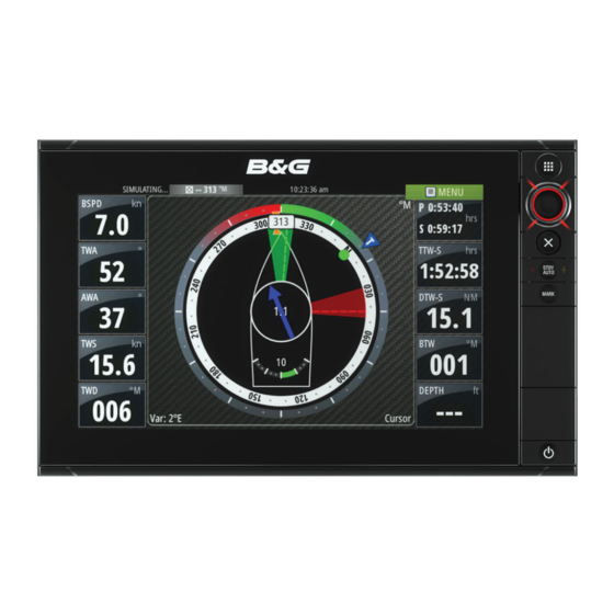
Page 43: Sailsteer Panel
- The selected field has a highlighted frame. Select the MENU button again to select info. Repeat the steps to change other instrument fields. Save your settings by selecting the save option in the menu. SailSteer panel | Zeus2 Operator Manual... -
Page 44: Sail Time Calculations
SailSteer overlay. If the Look ahead menu option is not selected, then the SailSteer overlay is displayed with all the orientation settings: North up, Heading up, and Course up. SailSteer panel | Zeus2 Operator Manual... -
Page 45: Race Panel
Data panel shows start line data and a graphical representation of the start line in the same way as an H5000 Graphic Display. It displays boat distance from the start line, tide direction, recommended start end bias and what advantage in degrees and distance the biased end will give. Race panel| Zeus2 Operator Manual... -
Page 46: Setting Up A Start Line
Ú Note: Before setting the start line position using the ping method, it is important that the Bow off set is updated to negate the difference between the GPS position and the bow of the vessel. Race panel| Zeus2 Operator Manual... -
Page 47: Removing End Points And The Start Line
Bearing of the end points from each other. Removing end points and the start line Use the Clear Port or Clear Starboard menu options to remove the start points. When both are removed, the start line is removed. Race panel| Zeus2 Operator Manual... -
Page 48: Start Line Display
Select the Use boat lengths setting to show the distance behind the line and Bias advantage in boat length data measurements on the Start line panel. Showing the measurements in boat lengths can give a clearer indication of the distance from your boat to the start line. Race panel| Zeus2 Operator Manual... -
Page 49: What If
Tools panel. The Timer set value is in hh:mm, the timer counter shows in mm:ss, with the hours showing to the right of the minutes and seconds. Race timer panel Race Timer in the Trip Log Race panel| Zeus2 Operator Manual... - Page 50 Rolling timer When Rolling timer is selected, the timer restarts the countdown timer every time it reaches zero. It continues to do this until the timer is stopped. Race panel| Zeus2 Operator Manual...
-
Page 51: Time And Wind Plots
The Wind Plot panel includes wind direction and wind speed. The graphics are configured vertically with the newest data being displayed at the top of the screen. Time and Wind plots| Zeus2 Operator Manual... -
Page 52: Autopilot
Refer to "Using the autopilot in an EVC system" on page 60. Autopilot indication on the pages Autopilot indication in Status bar Autopilot pop-up Autopilot tile in Instrument bar Autopilot| Zeus2 Operator Manual... - Page 53 The number of data fields included in the autopilot panel is dependent on available panel size. Data fields The following abbreviations are used in the autopilot panel: Course to steer Distance to destination WPT DIST Distance to next waypoint Autopilot| Zeus2 Operator Manual...
-
Page 54: Mode Overview
In FU mode you use the rotary knob to control the rudder angle. Press the rotary knob, then turn the knob to set the rudder angle. The rudder moves to the commanded angle and then stop. Autopilot| Zeus2 Operator Manual... -
Page 55: Auto Mode (Auto Compass)
NoDrift mode. Dodging If you need to avoid an obstacle when using NoDrift mode, you can set the autopilot to STBY and power steer or use the helm until the obstacle is passed. Autopilot| Zeus2 Operator Manual... -
Page 56: Nav Mode
The intention is to make the autopilot start the heading change in due time to make a smooth turn onto the next leg. The figure below may be used to select the appropriate waypoint circle when creating the route. Autopilot| Zeus2 Operator Manual... -
Page 57: Wind Mode
The time to make a gybe is determined by the speed of the boat to make it as quick as possible within control. Tack and gybe prevent You should use the autopilot with care when beating and running. Autopilot| Zeus2 Operator Manual... -
Page 58: Wind Nav Mode
Steers the vessel in a circle. You can adjust the Rate of turn from the turn dialog before the turn is initiated and during the turn. Increasing the turn rate makes the vessel turn a smaller circle. Autopilot| Zeus2 Operator Manual... - Page 59 Activate AUTO mode, select depth contour steering and monitor the depth reading. Select the port or starboard option in the turn dialog to initiate the depth contour steering to follow the bottom sloping to starboard or to port: Autopilot| Zeus2 Operator Manual...
-
Page 60: Using The Zeus 2 In An Ap24/Ap28 System
The mode indicator on the pilot pop-up is replaced by a dash to indicate EVC override. The system returns to Zeus control in standby mode if no rudder command is given from the EVC system within a predefined period. Autopilot| Zeus2 Operator Manual... -
Page 61: Autopilot Settings
Tack angle This value is used to preset the course change used when tacking in AUTO mode. By pressing the port and starboard indicators in the autopilot pop-up the course changes as much as this value. Autopilot| Zeus2 Operator Manual... - Page 62 This option displays an overview of all autopilot steering parameters, and you can adjust parameters if required. For more details, refer to the separate Zeus Installation manual. Installation Used for autopilot installation and commissioning. See the separate Zeus Installation manual. Autopilot| Zeus2 Operator Manual...
-
Page 63: Radar
Racons. You can select a dual radar panel by pressing and holding the Radar application button on the Home page, or by creating a favorite page with two radar panels. Radar| Zeus2 Operator Manual... -
Page 64: Radar Overlay
These are Fast Scan, Antenna Height and Bearing alignment. MARPA is fully independent and up to 10 targets may be tracked for each virtual radar source. Up to two independent Guard Zones may also be defined for each virtual radar source. Radar| Zeus2 Operator Manual... -
Page 65: Using The Cursor On A Radar Panel
You may be able to improve the radar image by adjusting the radar sensitivity, and by filtering out the random echoes from sea and weather conditions. You can also adjust the image settings from the radar menu. Directional clutter rejection (Broadband 4G Radar only) Radar| Zeus2 Operator Manual... -
Page 66: Advanced Radar Options
Target expansion Target expansion increases the length of targets in range, making them easier to see. Rejecting radar interference Interference could be caused by radar signals from other radar units operating in the same frequency band. Radar| Zeus2 Operator Manual... -
Page 67: Radar View Options
Rotates the radar image to display the current navigation course directly up. This option works only when the system is navigating an active route. If you are not navigating an active route, the heading up orientation is used until the navigation function is started. Radar| Zeus2 Operator Manual... -
Page 68: Ebl/Vrm Markers
Select the save option in the menu to save your settings Placing EBL/VRM markers by using the cursor Position the cursor on the radar image Activate the menu Select one of the EBL/VRM markers Radar| Zeus2 Operator Manual... -
Page 69: Setting A Guard Zone Around Your Vessel
When no signals have been received within a time limit a target will be defined as lost. The target symbol represents the last valid position of the target before the reception of data was lost. Radar| Zeus2 Operator Manual... -
Page 70: Recording Radar Data
A recorded radar file can be used for documenting an event or an operational error. A logged radar file can also be used by the simulator. If more than one radar is available, you can select which source you want to record. Radar settings Radar| Zeus2 Operator Manual... - Page 71 "Defining dangerous vessels" on page 98. An alarm triggers if a vessel is tracking into your safe zone. Installation The Installation option is used for radar installation, described in the separate Radar or Zeus Installation manuals. Radar| Zeus2 Operator Manual...
-
Page 72: Echosounder
You can zoom the Echosounder image by: • turning the rotary knob • using the panel zoom icons • pinching or spreading on the screen Zoom level is shown on the upper left side of the panel. Echosounder| Zeus2 Operator Manual... -
Page 73: Using The Cursor On The Echosounder Panel
You can use the menu to re-position the start point and the end point as long as the measuring function is active. When you select Finish measuring or press the X key, the image resumes to normal scrolling. Echosounder| Zeus2 Operator Manual... -
Page 74: Saving Waypoints
Preset range levels Allows for the selection of a specific depth range that is not tied to the depth of the water. Custom range This option allows you to manually set both upper and lower range limits. Echosounder| Zeus2 Operator Manual... -
Page 75: Advanced Echosounder Options
Ú Note: In certain conditions it may be necessary to adjust the scroll speed to get a more useful image. Such as adjusting the image to a faster speed when vertically fishing without moving. Echosounder| Zeus2 Operator Manual... -
Page 76: Start Recording Log Data
Files option. Upload to Insight Genesis Files are transmitted to Insight Genesis when recording completes, if you are connected to a wireless hotspot. For information about wireless hotspots, refer to "Wireless connection" on page Echosounder| Zeus2 Operator Manual... -
Page 77: Stop Recording Log Data
(0) and upwards. The bottom and the zero line are always shown on the left image, independent of the range scale. The scaling factor for the image on the left side of the panel is adjusted as described for the Zoom option. Echosounder| Zeus2 Operator Manual... -
Page 78: Echosounder Settings
Fish symbols and depth indication Ú Note: Not all fish symbols are actual fish. Echosounder settings Echosounder source If you have Network Echosounder enabled, you can select which Echosounder to be the preferred source on this Zeus unit. Echosounder| Zeus2 Operator Manual... - Page 79 By setting the search depth manually the system displays echoes received from objects within the set depth range. Installation Used for installation and setup. See the separate Zeus Installation manual. ForwardScan Installation Used for ForwardScan installation and setup. Refer to the "ForwardScan setup" on page 89. Echosounder| Zeus2 Operator Manual...
-
Page 80: Structurescan
By default, the cursor is not shown on the StructureScan image. When you position the cursor on a DownScan image; the screen pauses, the cursor information window and the history bar are activated. On a DownScan image, the depth is shown at cursor position. StructureScan| Zeus2 Operator Manual... -
Page 81: Saving Waypoints
When you select Finish measuring or press the X key, the image resumes to normal scrolling. Saving waypoints You can save a waypoint at a selected location by positioning the cursor on the panel, and then selecting the new waypoint option in the menu. StructureScan| Zeus2 Operator Manual... -
Page 82: Viewing Structurescan History
You can select between several display palettes optimized for a variety of fishing conditions. Pausing the StructureScan image You can pause the StructureScan image, allowing you to examine the structures and other images in more depth and detail. StructureScan| Zeus2 Operator Manual... -
Page 83: Advanced Structurescan Settings
Range lines can be added to the image to make it easier to estimate depth (Downscan) and distance (SideScan). Recording StructureScan data You can record StructureScan data and save the file internally in the Zeus unit, or onto an SD card as described in "Start Recording echosounder data" on page 76. StructureScan| Zeus2 Operator Manual... -
Page 84: Structuremap
When increasing the search range, the ping speed of the StructureScan transducer is reduced, but the width and the length of the image history is increased. Ú Note: Live mode does not save any data. If the unit is turned off, all recent data is lost. StructureMap| Zeus2 Operator Manual... -
Page 85: Structuremap Tips
You adjust the StructureMap settings from the Structure options menu. The menu is available when Structure overlay is enabled. Not all options are available when saved StructureMap files are used as the source. Unavailable options are greyed. Range Sets the search range. StructureMap| Zeus2 Operator Manual... - Page 86 The noise rejection option filters the signal interference and reduces on-screen clutter. Clear live history Clears existing live history data from the screen and begins showing only the most current data. Record data Records StructureScan data. Source Selects StructureMap source. StructureMap| Zeus2 Operator Manual...
-
Page 87: Forwardscan
Do not use this equipment to gauge depth or other conditions for swimming or diving. The ForwardScan image Transducer location shown as the origin on the page Depth range scale and vessel position Forward range scale Point data Bottom Depth history ForwardScan| Zeus2 Operator Manual... -
Page 88: Setting Up The Forwardscan Image
Displays lines on the screen that make it easier to quickly estimate depth and the underwater objects. Heading extension You can use the heading extension to monitor ForwardScan on the chart panel. Heading extension colors are based on the ForwardScan alarm values. ForwardScan| Zeus2 Operator Manual... -
Page 89: Forwardscan Setup
If you travel into water shallow enough to cross into the critical zone, the Critical Zone alarm is activated. You can display the critical warning zones by activating the Show zones menu option. ForwardScan| Zeus2 Operator Manual... - Page 90 For example, -2.0. B) For Depth Below Transducer: no offset required. C) For Depth Below Surface (waterline): Set the distance from transducer to the surface - this should be set as a positive value. For example,+0.5. ForwardScan| Zeus2 Operator Manual...
-
Page 91: Wireless Connection
To use smartphones and tablets to view and control the system, wireless functionality must be disconnected from the wireless hotspot (in Access point mode). Ú Note: For safety reasons, Autopilot and CZone functions cannot be controlled from a wireless device. Wireless connection| Zeus2 Operator Manual... -
Page 92: Uploading Log Files To Insight Genesis
‘Channel’ can be changed if the connection to unit is compromised due to interference. ‘Mode’ can be changed on WIFI-1 devices only. Restore defaults returns the unit to factory settings. Wireless connection| Zeus2 Operator Manual... - Page 93 Iperf and DHCP Probe are tools provided for diagnostic purposes by users familiar with network terminology and configuration. Navico is not the original developer of these tools, and does not provide support related to their use. Wireless connection| Zeus2 Operator Manual...
-
Page 94: Ais
From a chart panel you can search for AIS targets by using the Find option in the menu. If the cursor is active, the system searches for vessels around the cursor position. Without an active cursor, the system searches for vessels around your vessel's position. | Zeus2 Operator Manual... -
Page 95: Calling An Ais Vessel
An alarm message is displayed If you have enabled the siren, the alarm message is followed by an audible alarm. Ú Note: The icon is green if the received AIS SART data is a test and not an active message. | Zeus2 Operator Manual... -
Page 96: Vessel Alarms
You can define several alarms to alert you if a target shows up within predefined range limits, or if a previously identified target is lost. Dangerous vessel Controls whether an alarm will be activated when a vessel comes within the predefined CPA or TCPA. Refer to "Defining dangerous vessels" on page 98. | Zeus2 Operator Manual... -
Page 97: Vessel Settings
The length of the extension lines is either set as a fixed distance, or to indicate the distance the vessel will move in the selected time period. If no options are turned on for This vessel then no extension lines are shown for your vessel. | Zeus2 Operator Manual... - Page 98 A different line style is used on the extension lines to indicate motion, as shown below. AIS vessels shown with Absolute motion AIS vessels shown with Relative motion AIS icon orientation Sets the orientation of the AIS icon, either based on heading or COG information. | Zeus2 Operator Manual...
-
Page 99: Instrument Panels
Select the gauge you want to change. Selected gauge is indicated with a colored background. Select information to be displayed, configure limits, and eventually change the source for the information. Save your changes by selecting the save option in the menu. Instrument panels| Zeus2 Operator Manual... -
Page 100: Audio
Installation manual and to the documentation included with the audio device. Enabling audio A compatible audio device connected to the NMEA 2000 network should automatically be identified by the system. If not, enable the feature from the Advanced Settings dialog. Audio| Zeus2 Operator Manual... -
Page 101: The Audio Panel
Press and hold to tune in a channel forward track Select to select next/previous favorite channel Select to start Select to pause playback Select to display the volume slider Audio tools Icon Tuner Playback Signal strength Audio| Zeus2 Operator Manual... -
Page 102: Setting Up The Audio System
Select the options icon and then select the audio server Select the source icon and then select the audio source - Number of sources depends on the active audio server Use the panel buttons to control your audio system Audio| Zeus2 Operator Manual... -
Page 103: Favorite Channels
You can create a list of your favorite Sirius channels from within the channels list. You cannot add unsubscribed channels. Locking channels You can lock selected Sirius channels from being broadcasted. A 4-digit-code must be entered to lock channels and the same code entered to unlock the channels. Audio| Zeus2 Operator Manual... -
Page 104: Weather
Ú Note: GRIB data that is imported from an SD card is not saved in the Zeus . The data is lost when new GRIB data is imported. Select the GRIB file to import the data. Weather| Zeus2 Operator Manual... - Page 105 The time shift is shown in brackets in the GRIB information window. The time is relative to the current time as provided by a GPS device connected to the system. Weather| Zeus2 Operator Manual...
-
Page 106: Siriusxm Weather
Sirius weather display Sirius weather can be displayed as an overlay on your chart panel. When weather overlay is selected, the chart menu increases to show the available weather options. Precipitation color shading City forecast icon Wind barb Weather| Zeus2 Operator Manual... - Page 107 Sirius™ service includes access to weather reports for all U.S. Marine Zones, with the exception of the high seas zones. You can setup the system to read the forecast for a selected area. Select the selected zone, and use the menu to confirm your selection. Weather| Zeus2 Operator Manual...
-
Page 108: Weather Alarms
You can also set up an alarm as a severe weather forecast alarm issued for your chosen marine zone. A watchbox is defined by the National Weather Service. When the alarm for watchbox is turned on, an alarm occurs when your vessel is entering or inside a watchbox. Weather| Zeus2 Operator Manual... -
Page 109: Video
For instructions on how to configure your specific FLIR camera model, refer to FLIR documentation. Ú Note: Only one FLIR camera can be connected to the Ethernet network. When you activate a video panel, the system starts searching the network for a FLIR camera. Video| Zeus2 Operator Manual... - Page 110 Inverts the color scheme. For example, instead of: White = Hot and Black = Cold, it becomes Black = Hot and White = Cold. The FLIR camera’s home position You can set the current pan and tilt position as the camera’s home position. You can later quickly return to this camera position. Video| Zeus2 Operator Manual...
-
Page 111: Alarms
Disables the current alarm setting. The alarm does not show again unless you turn it back on in the Alarms dialog. There is no time-out on the alarm message or siren. They remain until you acknowledge the alarm or until the reason for the alarm is removed. Alarms| Zeus2 Operator Manual... -
Page 112: Alarms Dialog
Alarms dialog All alarms are setup in the Alarms Settings dialog. The alarm dialogs can also be activated from the Tools panel. The alarm dialogs include information about active alarms and alarm history. Alarms| Zeus2 Operator Manual... -
Page 113: Tools
Displays voyage and engine information, with reset option for all data fields. Today Displays voyage and engine information for current date. All data fields are automatically reset when the date changes. Files File management system for Files, Waypoints, Routes, Tracks, and Settings. Tools| Zeus2 Operator Manual... -
Page 114: Find
Find Search function for chart items (waypoints, routes, tracks, etc.). Tools| Zeus2 Operator Manual... -
Page 115: Simulator
You can select which data files are used by the simulator. A set of source files is included in your system, and you can import files by using a card inserted into the card reader. You can also use your own recorded files in the simulator. Simulator| Zeus2 Operator Manual... -
Page 116: Advanced Simulator Settings
Set start position Moves your vessel to the current cursor position. Ú Note: This option is only available when the GPS source is set to Simulated course. Sailing Opens dialog for selecting sail specific simulator data. Simulator| Zeus2 Operator Manual... -
Page 117: Maintenance
The system logs as much data as possible within the file size limitation, and then it starts overwriting the oldest data. Maintenance| Zeus2 Operator Manual... -
Page 118: Software Upgrades
Use the export option if you want to backup all Waypoints, Routes, and Tracks on your system. Export region The export region option allows you to select the area from where you want to export data. Drag the boundary box to define the desired region Maintenance| Zeus2 Operator Manual... - Page 119 This is necessary to allow user data to be synchronized across multiple units on an Ethernet network. If you have numerous deleted, unpurged Waypoints, purging may improve the performance of your system. Ú Note: When user data is purged from the memory, it cannot be recovered. Maintenance| Zeus2 Operator Manual...
- Page 120 Dynamic tides and currents 26 Follow-up steering 54 Easy view 27 Gybing 57 Fish N' Chip 27 HI/LO parameters 62 Presentation type 28 Indication in Status bar 53 Rock filter 28 Indication on pages 52 Index | Zeus2 Operator Manual...
- Page 121 Go to cursor 23, 65, 73, 81 EBL/VRM markers 68 GoFree Echosounder 72 Shop 91 A-Scope 78 Wireless connection 91 Depth offset 90 GoFree Fish ID 78 Controller & Viewer app 91 Image 72 Great circle 41 Index | Zeus2 Operator Manual...
- Page 122 Palette 67 Network Position radar center 68 Echosounder 79 PPI 68 NMEA Data logging 117 Radar overlay source 64 NMEA Radar panel 63 Exporting log file 118 Rain clutter 66 Noise rejection 75 Range 64 Index | Zeus2 Operator Manual...
- Page 123 Overlay on chart panel 106 Precipitation 107 Temperature graph 78 Sea Surface Temperature (SST) 107 Time plot panel 51 Status panel 106 Missing data 51 Tropical statements 108 Time plots 51 Wave indication 107 Selecting data 51 Index | Zeus2 Operator Manual...
- Page 124 Saving 24, 35, 65, 74, 81 Weather 104 Alarms 108 Showing weather details 104 Wind barbs 104 Wind plot panel 51 Wind plots 51 Wireless hotspot Connect and disconnect 91 XTE limit 41 xtf format 76 Index | Zeus2 Operator Manual...
- Page 126 0980...
Need help?
Do you have a question about the Zeus2 and is the answer not in the manual?
Questions and answers