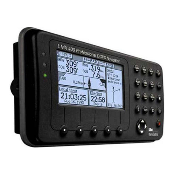
Sign In
Upload
Manuals
Brands
Leica Manuals
GPS
MX400
Leica MX400 Manuals
Manuals and User Guides for Leica MX400. We have
1
Leica MX400 manual available for free PDF download: Operating Instructions Manual
Leica MX400 Operating Instructions Manual (231 pages)
Brand:
Leica
| Category:
GPS
| Size: 4.81 MB
Table of Contents
Product Information
2
Symbols Used in this Manual
3
Scope of this Manual
4
Related Documents
4
How to Contact Us
5
Table of Contents
6
About GPS Navigation
14
Special Notes
15
Gps
15
Dgps
15
Charts and Navigational Aids
16
Functional Description
17
Receiver Configurations
17
Channel GPS
17
Channel GPS with Built-In Beacon
17
12 Channel GPS with Built-In Beacon
18
Channel Dual Control
18
12 Channel Dual Control Integrity Monitor
19
DGPS Beacon System
21
Keypad & Display Description
23
Differential GPS Traffic Light Operation
23
Red Flashing
24
Red/Yellow Solid
24
Red Solid
24
Yellow/Green Solid
24
Yellow Solid
24
Green Solid
25
GPS Traffic Light Operation
25
Red Flashing
25
Red/Yellow Solid
25
Red Solid
26
Yellow Solid
26
Green Solid
26
The Display
26
The Softkeys
27
The Function Keys
27
Mark Position
28
Goto O
28
Light
28
Power On/Off
29
Man over Board (Mob)
29
E E (Edit)
30
C C (Clear)
31
Cursor
31
N Av
31
Abc
31
Function
31
Navigate
33
N Av Function
33
Dead Reckoning
34
NAV1 - the Panorama Screen
35
NAV2 - Basic Steering Information
37
NAV 3 - Expanded Navigation Information
39
NAV4 - Sensor Input Navigation
40
Route
44
RTE1 - the Active Route
45
Creating a Route Using the GOTO Key
46
Erasing an Existing Route
49
Creating a Multi-Waypoint Active Route
50
Insert by Number
51
Choose in Bank
52
Insert New Waypoint
53
Insert Route
54
Maneuvering Within the Route
55
Scrolling
55
Skipping and Unpassing Waypoints
55
Inserting Waypoints or Routes into an Existing Route
56
Reversing the Active Route
59
ETA Setup
60
SOG Based on Arrival Date & Time
61
ETA Based on Speed
61
RTE2 - the Route Bank
62
Waypoint
64
Creating and Editing Waypoints
65
Waypoint Lock/Unlock
70
To Lock a Waypoint
71
To Unlock a Waypoint
71
To Lock All Waypoints
72
To Unlock All Waypoints
72
Removing Waypoints
73
Moving Waypoints
74
Downloading Waypoints & Routes to Other Devices
76
Rnn - Routes
76
RTE - Active Route
77
WPL - Waypoint Location - NMEA 0183 Standard
78
WPL - Waypoint with Symbols & Description - NMEA 0183 Expanded
78
Downloading Waypoints to a Personal Computer
79
Uploading Waypoints from Other Devices
81
Uploading Waypoints from a Personal Computer
82
Mark or Event
84
Goto O
86
Plot
88
PLOT 1 - Relative to Boat
90
Modifying the Active Route Using the Plot Screen
90
Customizing the Display
92
PLOT 2 - Relative to Marker
95
Plot Screen Use Examples
96
Station Keeping
96
Grid Search
97
Man over Board
99
Remote MOB
100
Tide
101
TIDE1 - Current Tide Display
101
TIDE2 - Tide Table Port List
102
Adding a Port
104
Auxiliary
106
AUX1 - Alarm Log
106
AUX2 - Speed Graph
106
AUX3 - Fuel Information
106
AUX4 - Sun Almanac
106
AUX5 - Moon Phases
106
AUX6 - Batteries
106
AUX7 -Unit Information
106
Position
111
POS1 - Large Position Display
111
Loran-C
112
User Grid
112
Utm
113
Decca
113
POS2 - Position, Altitude, Magnetic Variation, & Time
113
POS3 - Position & Log
114
Gps
116
GPS1 - Current Satellite Status
116
For 6 Channel GPS Models
116
For 12 Channel GPS Models
118
GPS2 - GPS Health (All Models)
119
Dgps
123
DGPS1 - Current DGPS Correction Status
123
DGPS3 - DGPS Messages
125
Configuration
126
Alarms
126
Anchor - Anchor Watch Alarm
127
COG SOG - Course & Speed Filter Settings & Setup
127
Compass - External Compass Input & Magnetic Variation Table
128
Datum - Current Position Calculation
129
Depth - NMEA Input Control
130
DGPS - Differential Correction Input Control
131
DR - Dead Reckoning
135
Dual Contr. - Dual Station Control
136
Fuel - Fuel Input Calibration & Control
136
GPS - Elevation Mask & Antenna Offset Control
138
Init Pos - Initial Position Entry
139
Language - Foreign Language Setup
140
Lighting - Display/Keyboard Light & Contrast Control
141
Log - Speed Log Input (Pulse or NMEA 0183)
142
Log Pulses - GPS SOG Log Pulse Output
144
MX 480 - MX 480 PC Chart Interface Control
144
Navigation - Navigation Method & Waypoint Pass Criterion Control
145
NMEA out 1 Thru 4 - NMEA 0183 Output Data Control
148
Other Special Cases Affecting NMEA 0183 Records
153
Operation - General Setup and Control Settings
154
Organizer - Automated Message Reminders
156
Position - Positioning Reference, Mode, & Alarm Control
157
Printout 2 - Printer Output Control
159
Security
162
Set & Drift
162
SJB - Smart Junction Box Control
163
Time - Mode and Format Control
165
Wind
166
Wpt & Rte Input - Uploading Waypoints into the Receiver
167
Appendix A - Datum List
168
Appendix B - Beacon List
177
Appendix C- Engineering Mode
188
AUX7 - Unit Information & Self Test
188
Receiver Cold Start - Clearing Memory to Factory Default
190
GPS - GPS Receiver Troubleshooting
191
GPS6 - Visible Satellite Information
191
GPS7 - GPS Position Uncertainty
192
GPS8 - Oscillator Offset Temperature Curve Fit
193
GPS9 - GPS Debug Screen
194
DGPS8 - Beacon Receiver Status
196
Beacon Signal Scope
197
Appendix D - Dual Control Head Mode
199
Turning Master and Slave Units off
201
Appendix E - Demonstration Mode
202
Appendix F - Software Updates
204
Glossary
209
Advertisement
Advertisement
Related Products
Leica MojoMINI
Leica MK8
Leica MK9
Leica MK9DC
Leica mojo3D
Leica mojo 3D
Leica MX420
Leica MX421 Series
Leica M 240
Leica MCR-900
Leica Categories
Digital Camera
Microscope
Measuring Instruments
Laboratory Equipment
Laser Level
More Leica Manuals
Login
Sign In
OR
Sign in with Facebook
Sign in with Google
Upload manual
Upload from disk
Upload from URL