
Related Manuals for Simrad MX510


Summary of Contents for Simrad MX510
-
Page 1: Navigation Systems
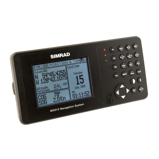
Manual Simrad MX510 and MX512 Navigation Systems English www.simrad-yachting.com A brand by Navico - Leader in Marine Electronics... - Page 3 As we are continuously improving our products we retain the right to make changes to the product and the documentation at any time. Updated manuals are available from our website www.simrad-yachting.com, and are free to download. © Copyright 2010 by Navico Holding AS.
-
Page 4: Important Notice
The model and serial number of your instrument are given on the instrument. Enter the model and serial number in the spaces provided below. Always refer to this information when you contact your dealer. MX51_ CDU Serial No.:_________________ Antenna Model: __________________ Antenna S/N: __________________ 2 | MX510/MX512 Operator & Installation Manual... -
Page 5: About This Manual
MX51x/BR MX51x/BRIM MX51x/MUC This manual covers the operation and installation of both the MX510 and MX512 CDU models. The keypad operation of these models are identical. We have attempted to take care and develop manuals which provide in-depth information. Where possible, we have attempted not only to describe what you see on the screen, but how to understand and use it as well. - Page 6 Blank page 4 | MX510/MX512 Operator & Installation Manual...
-
Page 7: Table Of Contents
Contents 1 About GPS Navigation ............11 Special notes ............... 11 2 Functional Description ............. 13 CDU Configurations ..............13 Basic CDU configuration ..........13 MX51x DGPS..............13 MX51x/BR ..............13 MX51x/BRIM (Backup Receiver Integrity Monitor) ..... 14 MX51x/MUC (Multi Unit Control) ........14 3 DGPS Beacon System ............ - Page 8 NAV3 - Expanded Navigation Information ......25 NAV4 - Sensor Input Navigation ........26 NAV5 - Compass Display Screen ........28 NAV6 - Compass Display Screen ........28 Route ................28 RTE1 - The Active Route ..........29 Creating a Route Using the GOTO Key: ......29 Erasing an Existing Route ..........
- Page 9 AUX1 - Alarm Log ............59 AUX2 - Speed Graph .............59 AUX3 - Not Used ............60 AUX4 - Sun Almanac .............60 AUX5 - Moon Phases .............60 AUX6 - Batteries ............60 AUX7 -Unit Information ..........60 AUX 10 - Tide .............. 61 Current Tide Display ............. 61 AUX 11 - Tide Table Port List ..........62 Adding a Port ...............63 Position ..............64...
- Page 10 Antenna Installation ............ 101 MX51x Navigator Installation ........102 Equipment Interfacing ..........103 Mechanical installation drawings ........... 115 MX510 Electrical installation drawings ........123 MX512 Electrical installation drawings ........131 6 Technical specifications ..........141 Appendix A - Datum List ............ 145 Appendix B - Engineering Mode .........
- Page 11 CDU Cold Start - Clearing Memory to Factory Default ..... 148 GPS - GPS CDU Troubleshooting ........... 149 GPS3 - Visible Satellite Information ......149 GPS4 - GPS Position Uncertainty ........149 Antenna Reset Tools ........... 150 Appendix C - Multiple Unit Control (Via LAN) ....151 Dual Control Configuration: ..........
- Page 12 Blank page 10 | Contents...
-
Page 13: About Gps Navigation
1 About GPS Navigation This GPS receiver is a precision navigation instrument utilizing the latest technology available today to provide optimum performance from the GPS satellite and Beacon land signals received. As with all other forms of radio signals, the ultimate navigation result is dependent upon the quality of these signals. - Page 14 Blank page 12 | About GPS Navigation...
-
Page 15: Functional Description
Basic CDU configuration The MX510 has two (2) bidirectional user NMEA ports while the MX512 has nine (9) bidirectional user NMEA ports. Both models have one (1) high-speed Local Area Network (LAN) port and two USB ports. The basic GPS navigation model includes the CDU and a... -
Page 16: Mx51X/Brim (Backup Receiver Integrity Monitor)
MX51x BR Beacon and Remote Configuration MX51x/BRIM (Backup Receiver Integrity Monitor) The MX51x/BRIM is an enhanced Dual-Control configuration wherein two MX51x CDUs and two MX521A smart DGPS antennas are supplied. The two MX51x units are connected in dual-control configuration but they operate as independent navigator units with dedicated antennas. -
Page 17: Dgps Beacon System
3 DGPS Beacon System As Maritime Safety Administrations, Navy, and Coast Guard Organizations realize the limitations of standard GPS positioning, many have begun installing DGPS Beacon Stations. While an understanding of this system is not necessary for operating receivers with internal beacon receivers, you may want to read on to have a better understanding of how your receiver is capable of achieving the high levels of accuracy made possible by this network of transmitters. - Page 18 Blank page 16 | DGPS Beacon System...
-
Page 19: Keypad & Display Description
4 Keypad & Display Description The MX510 and MX512 keypad operation and traffic light indications are identical. The Traffic Lights on the right side of the display will tell you how your navigator is operating. You need to take care in reading the traffic light indications, as there are overlapping possibilities between the GPS and DGPS modes. -
Page 20: Gps Traffic Light Operation
Yellow/Green Solid GPS position update; DGPS corrections are not being received. You may see this from time to time during normal operation. It usually occurs when the beacon signal is not available (either it is being blocked by terrain or a local object or you are out of range of the transmitter) and/or you are tracking 3, 4, or 5 satellites, and the satellites have poor geometry relative to your position. -
Page 21: The Display
Green Solid GPS position update with HDOP value less than 4. This is the normal operating condition. Position accuracy is normally between 3 to 5 meters, but can be out as much as 30 meters. Keep in mind that position accuracy is always only as good as the geometry of the satellites and the navigation information provided by the satellites. -
Page 22: The Function Keys
The Function Keys: The MX51x has 17 function keys. These keys are used to directly access various navigation, positioning, GPS, configuration and other screens. One function key is used to mark your present position, and to activate the Man-Over-Board feature when depressed for a few seconds. -
Page 23: Goto
GOTO This function key allows you to quickly create a route from your present position to waypoint or a route. This single waypoint route can use an existing waypoint from the Waypoint Bank, or you can quickly create one by either defining the appropriate coordinates or specifying a range and bearing. -
Page 24: Function Keys
FUNCTION Keys You might have noticed that above and below each primary function key are numbers and letters. These numbers and letters are used when you are in the edit mode. You will find that they are most often used in the RTE, WPT, and CFG screens, but they are used in other screens as well. -
Page 25: Dead Reckoning
• GPS Offset - sets an offset for calculating the GPS antenna position if you can’t physically locate the antenna exactly where you want it (e.g. over the centerline of the boat). • Navigation - sets a variety of important functions and alarms Rhumb line or Great Circle navigation Range units: nautical miles, nautical miles and meters (when under 1000 meters), nautical miles and feet (when under 1000 feet), statute miles, statute miles and... - Page 26 Waypoint Bank (WPT1) where a symbol is used as the first character of the waypoint description. The Panorama and Plot screens will automatically place these navigation markers on the screen as you approach them. The degree values that you see are your Course Over Ground (COG), as calculated by the GPS receiver’s position fix to position fix, and Bearing (BRG) from your present position to the waypoint.
-
Page 27: Nav2 - Basic Steering Information
NAV2 - Basic Steering Information The NAV2 screen provides the bearing (BRG) and range (RNG) to the waypoint you are approaching in large bold characters. Below these, you will see your actual Course Over Ground (COG) and Speed Over Ground (SOG). The bottom portion of the screen provides cross-track error information. -
Page 28: Nav4 - Sensor Input Navigation
NAV4 section which follows. You will find the right hand window to be a helpful tool. In addition to identifying the waypoint you are currently approaching, it identifies the waypoint at the end of the next leg. The really unique feature of this screen is the graphical representation of your actual course line approach angle relative to the next leg of your course. - Page 29 data to calculate your speed parallel to wind and can output the VPW NMEA 0183 data sentence to other on-board instruments. The window below the wind data provides information relating to your course and speed. You will find the Course Over Ground (COG calculated by the MX421 smart GPS antenna), Heading (HDG, your NMEA 0183 compass input), and Heading To Steer (HTS) data on the left side of the window.
-
Page 30: Nav5 - Compass Display Screen
NAV5 - Compass Display Screen The NAV5 screen displays the Heading and Rate of Turn values of the MX575 Satellite Compass (or Gyro) in digital and compass row formats. In addition, it also displays the position, COG, SOG, BRG, and RNG. This screen can be accessed by pressing the NAV key repeatedly until you reach the desired NAV screen. -
Page 31: Rte1 - The Active Route
The RTE2 screen provides storage space for up to 100 user defined routes. You can pre-define routes, or copy new routes from the RTE1 (active route) screen. Later you can choose individual routes or link two or more routes in the RTE1 screen (refer to Creating a Multi-Waypoint Active Route section of this manual). - Page 32 route. Choose In Bank - allows you to scroll through the Waypoint Bank. Align the cursor with the desired waypoint and press the EDIT key. The waypoint is automatically inserted into the active route and the unit will revert to the NAV screen, displaying bearing and distance to this waypoint.
-
Page 33: Erasing An Existing Route
the screen. Waypoint 0, the first waypoint, is your Point of Departure, or the position you were at when you created the route. Waypoint 0 is a unique waypoint, in that the CDU internally changes the position of Waypoint 0 to your present position. However, the CDU saves and displays the original coordinates entered when you created the route. -
Page 34: Creating A Multi-Waypoint Active Route
Creating a Multi-Waypoint Active Route There are four methods to create a multi-waypoint route: • Insert By Number - allows you to type in or scroll through in numerical order using the cursor key, waypoints that you previously stored in the Waypoint Bank (see WPT later in this manual). -
Page 35: Choose In Bank
When you have found the waypoint you want, highlight the Insert this WPT softkey and press ENT. You can then choose to select another waypoint using the same method, highlight Escape and press ENT to go back one level and use another method to enter waypoints, or highlight Done and press ENT to go back to the main menu. -
Page 36: Insert New Waypoint
You can then choose to select another waypoint using the same method, select Escape to go back one level and use another method to enter waypoints, or select Done to go back to the main menu. Don’t forget to press the EDIT key to end your editing. -
Page 37: Maneuvering Within The Route
Use the cursor key to scroll through the available defined routes, which are created in the RTE 2 screen, in numerical order. When you have found the route you want, highlight the Insert Fwd or the Insert Reverse softkey and press ENT. Insert Fwd enters the route from the top of the defined list into the active route. - Page 38 Inserting Waypoints or Routes into an Existing Route Press the RTE key until the RTE1 screen is displayed. Scroll through the route points with the cursor key until the cursor arrow is at the waypoint you want to insert the new waypoint after. Then press the EDIT key.
-
Page 39: Eta Setup
Highlight Insert Reverse softkey, press ENT. Press the EDIT key to exit. Notice that you still keep the same orientation on the screen, in other words, you always read from the top of the screen to the bottom of the screen. The waypoints are rewritten in reverse order for you. -
Page 40: Rte2 - The Route Bank
In this mode, the actual SOG is compared to the required SOG to meet the specified arrival date and time. The result is given in a percentage (%) value next to the displayed SOG in the NAV screens. If the percentage is below 100, you will arrive late. If the percentage is above 100, you will arrive early. -
Page 41: Waypoint
Highlight the Done softkey and press ENT when you are finished editing the name. It is a good idea at this point to select Lock Route so that way you don’t accidentally erase the route. Finally press the EDIT key to exit the edit mode. The RTE1 screen is not active until the antenna is detected. - Page 42 press ENT to select it. Scroll left to “ Make new WPT” and press ENT to start entering L/L coordinates for waypoint #1 or if you want to modify an existing waypoint, highlight the “Edit this WPT” softkey then press ENT. a Make New WPT - Select Lat/Lon (W84), Lat/Lon Datum, or Range Bearing.
- Page 43 Move the cursor down and modify the waypoint number if you wish. Otherwise the CDU assigns the next available number, beginning at 1. Range & Bearing Lat/Lon This feature allows you to create a range of waypoints within a particular area. For example, you could put all of the waypoints for fishing spots near Catalina Island in the range of 500 to 530, all the waypoints for Cabo San Lucas in the range of 575 to 600, etc.
-
Page 44: Waypoint Lock/Unlock
Then press the EDIT function key to end editing. You can press the EDIT key when you finish editing a waypoint. This is treated the same as highlighting the Done softkey and press ENT. Highlighting Done then press ENT allows you to continue editing and entering other waypoints. Waypoint Lock/Unlock Locking a waypoint forces the user to consciously unlock the waypoint before it can be modified and prevents the waypoint from being overwritten when waypoints are being... -
Page 45: Removing Waypoints
Press the EDIT key. If you simply want to modify the waypoint, Edit this WPT will be displayed on the bottom left of the screen. To Lock all Waypoints Press the WPT key. Scroll to the desired waypoint. Press the EDIT key. -
Page 46: Moving Waypoints
There are three methods to remove a waypoint: Remove this WPT, Remove Unused, and Remove Range: If you select Remove this WPT, the waypoint will immediately be removed from the Waypoint bank. If you select Remove Unused, the CDU will delete all waypoints that are not locked or stored in a route. - Page 47 To move a range of waypoints, enter the first and last waypoint numbers to move on the First WPT Number and Last WPT Number. Keep in mind that the CDU will sort these waypoints numerically and all waypoints between the entered numbers will be moved to the new location.
-
Page 48: Saving Or Restoring Memory Data Using A Usb Device
Saving or Restoring Memory Data Using a USB Device The MX51x is equipped with two sealed USB connectors, one in front and one in the back of the unit. They can be used to conveniently save or restore navigation data such as waypoints, routes, plot tracks and configuration settings using a USB memory stick. -
Page 49: Downloading Waypoints & Routes To Other Devices
Change softkey is highlighted at this point, press ENT key. Wait for the MX51x to recognize the USB device before proceeding. Highlight “Data type” then press ENT to change to either Waypoints, Route, Plot, Config or All. Using “All” will restore everything. Highlight Restore softkey then press ENT. - Page 50 The CDU outputs these sentences in the following format: Rnn - Routes: Waypoint identifiers, listed in order with starting waypoint first, for route number “nn”. The active route in the CDU is always route zero, but in the Rnn sentence the route number can be transmitted as either route 00 or 01.
-
Page 51: Downloading Waypoints To A Personal Computer
Explanation / actual use: 2 & 3: Waypoint Latitude, North or South, N/S number of decimals can be set to 2, 3, 4 or 5 (default 2). 4 & 5: Waypoint longitude, East or West, E/W number of decimals can be set to 2, 3, 4 or 5 (default 2). -
Page 52: Uploading Waypoints From Other Devices
Scroll down the menu to NMEA Out 1 (or which ever port number is required). Press the EDIT key. If the port is already Active ( Yes), write down which NMEA sentences are set to Yes, then set all of the NMEA sentences to No. You need to do this to record just the waypoint data. -
Page 53: Uploading Waypoints From A Personal Computer
Uploading Waypoints from a Personal Computer You can use any terminal or communications program to download or upload waypoints and routes to or from the CDU and a PC. Set the PC to: 4800 baud 8 bits 1 stop bit no parity no flow control When sending data to the CDU, it must be sent in block form, followed by (with an appended) -
Page 54: Mark / Mob
Mark / MOB This is a dual function key that either stores your present position, date and time at the next available waypoint location in the Waypoint Bank or when pressed continuously for 3 seconds, calculates a MOB range and bearing to a saved spot (See MOB section on page 58). - Page 55 If you make a mistake, you can use the cursor key to position the cursor over the mistake and overwrite the error. Use the DGPS key or cursor key to insert a space in the description, if needed. Use the CFG key to select a special character, if needed. To activate the GOTO waypoint, press the EDIT key.
-
Page 56: Plot
Plot The PLOT1 screen displays graphic information around the boat at your present position. The boat always remains in the center of the screen. If you define some of your navigation markers in the Waypoint Bank with a symbol in the first character position, the navigation symbol will show up in relation to your planned course on the plot screen, just as it does in the NAV1 Panorama screen. -
Page 57: Plot 1 - Relative To Boat
PLOT 1 - Relative to Boat The information in PLOT1 is always relative to your present position. The boat always remains in the center of the screen and the bearing and range are always from your present position to the next waypoint identified in RTE1. Customizing the Display There are a number of display options available, press the EDIT key to modify the screen to your needs. - Page 58 • Show Lat/Lon Grid - No is the default condition, which causes the coordinate grid not to be displayed. Yes causes the Lat/Lon grid to be displayed (regardless of positioning reference system selection in CFG1 Position). Note that the grid is only displayed at the 4 Nm scale or lower.
-
Page 59: Plot Screen Use Examples
Plot Screen Use Examples Station Keeping There may be a time when you want to maintain your position at a given location in open water. Some applications for this need may be: • Staying over a dive wreck. • Staying over a fishing hole. •... -
Page 60: Man Over Board
Man Over Board The Man Over Board function key shares the same key with the “Mark or Event” function key. When depressed for 3 seconds, it activates a number of automatic functions described below. Most obviously, it brings up an MOB1 (Plot) screen. This is an automatic scaling screen. The screen centers on half the distance between your present position and the MOB position. -
Page 61: Remote Mob
Remote MOB The MX51x is capable of performing the MOB function from a remote contact closure input via the AUX (8-pin) cable. If the contact closure is made for 3 seconds, the input is registered as a MOB Position. Refer to the Installation section of this manual for wiring interface instructions. -
Page 62: Aux3 - Not Used
AUX3 - Not Used AUX4 - Sun Almanac This almanac provides the sunrise and sunset times for a given day and location. You can enter another date or location of interest by pressing the EDIT key, and editing the appropriate date and/or place. AUX5 - Moon Phases There are no edit functions available here. -
Page 63: Aux 10 - Tide
MX510 AUX7 Screens MX512 AUX7 Screen This also activates several engineering screens (the same as turning Engineering Display to Yes in CFG1 Operation). Refer to Appendix B - Engineering Mode for more details. AUX 10 - Tide There are two TIDE screens, which are located under the AUX option. The AUX 10 screen displays graphic and digital information about the tide conditions at your present position. -
Page 64: Aux 11 - Tide Table Port List
The tide measurement units can be displayed in meters, feet, or fathoms. Tide units are controlled along with depth units in the CFG1 Depth screen. To select another port’s tide table, press the EDIT function key, and use the Change softkey to scroll down the list or the Go Back softkey to scroll up the list. -
Page 65: Adding A Port
The display provides the required tide table document name and section (Admiralty Tide Tables, Part III) under the Help softkey when in the edit mode as an added aid to help you identify the proper reference material. Information about the Admiralty Tide Tables port lists and other publications and where they can be purchased is available from the official Admiralty Chart and Publications website at www.ukho.gov.uk. -
Page 66: Position
Position There are three POS screens in the CDU. The POS functions are highly interactive with a number of CFG1 menu selections. The following CFG1 menus directly impact the POS functions: • COG SOG - sets the filtering time for the displayed values. •... -
Page 67: User Grid
User GRID User defined grids is an optional feature of the MX51x. When enabled you can set the receiver to provide Easting and Northing position data based on a local grid. The grid function is set up in the CFG1 Position screen. A special license is required to activate this special feature. -
Page 68: Gps
provided so that you can log the mileage for: the current leg or day of your trip; and the entire trip. Several GPS and DGPS screens are available under the GPS function key. The GPS/ DGPS functions are highly interactive with these CFG1 menu selections: •... -
Page 69: Gps3 - Visible Satellites
You can deselect a particular PRN# by doing the procedure below: Press the EDIT key. Scroll to the PRN number desired. Highlight “force unhealthy” softkey, press ENT to change the value to “-”. Press the EDIT key to exit. GPS3 - Visible Satellites This screen provides some basic information about the GPS receiver performance just like GPS1 and GPS2 screens. - Page 70 The GPS5 screen shows the position Lat/Long, height of antenna, HDOP, number of satellites used, the satellite ID number that may cause the statistical error and its bias value. It also shows a table containing the PRN numbers of satellites in use, their residual errors and elevations.
-
Page 71: Gps6 - Dgps Status
GPS6 - DGPS STATUS There are several windows in this display, the left hand windows are divided into control and configuration windows. The right hand window displays all the corrections that are being received. Shown below is the GPS6 screen. MX51x GPS6 Screen Status will tell you whether the correction data is being decoded is error free or not. -
Page 72: Gps7 - Dgps Messages
Once you have entered the data for several beacon stations, you can cycle between these stations by pressing the Next Station or Previous Station softkeys. These softkeys are only displayed if you have entered a name for the reference station. The window on the right side of the display indicates which satellite ID’s are receiving corrections. -
Page 73: Configuration
Configuration The CFG screen includes setup and control of all of the MX51x’s primary functions. There are more than 20 separate configuration items in this screen. The display is divided into two windows. The left hand window identifies the primary configuration items. The right hand window displays the current settings. -
Page 74: Compass - External Compass Input & Magnetic Variation Table
Compass - External Compass Input & Magnetic Variation Table The MX51x will accept compass input using the NMEA 0183 data record of xxHDT, xxHDG, xxHDM, xxHCC, xxHCD, xxVHW, or any of the above. The “xx” refers to the Talker Identifier as specified in the NMEA 0183 standard. It will accept these data records vitually from any talker ID, and from any version (1.5 or higher) of the NMEA 0183 standard. -
Page 75: Datum - Current Position Calculation
MX575: There are two ways the MX575A DGPS compass can be connected to the MX51x, namely: • PORT3 as source of Positioning, Heading and ROT. • PORT1 (or 2) as source of Heading and ROT only If the MX575 is used as a positioning and heading device on NMEA Port3, set Data input port no to 3. -
Page 76: Dgps - Dgps Configuration
Echo Sounder Connected - causes the MX51x to look for one of the appropriate NMEA 0183 data sentences when set to Yes. Data Input Port No. - Select the appropriate NMEA 0183 port that the sensor is connected to (Port 1 or 2). Ports 3 and 4 are reserved for the Smart antenna controls. -
Page 77: Dr - Dead Reckoning
Off - sets the smart antenna to operate in GPS mode only. Max Age -sets the maximum age limit that the last received RTCM correction will be applied to the satellite range measurement in the receiver. The default setting is 600 seconds. -
Page 78: Gps - Elevation Mask Control
Whether a unit is a slave or repeater, it will still share a common waypoint and route database as the master. Refer to Appendix C for more detailed information about the dual-control and multiple unit control setup and operation. CFG1/LAN menu must be setup before enabling the Dual-Control feature. A dual control system consists of one Master and one Slave. -
Page 79: Initial Pos - Initial Position Entry
Initial Pos - Initial Position Entry This screen is provided to help the GPS receiver in the smart antenna to get a faster first position fix. While the smart antenna is capable of computing its position without any user input, this feature can cause a position fix to occur several minutes earlier. Another time this feature is useful is when the MX51x has been moved over 300 miles from the last location it was used while in the off condition. -
Page 80: Lan Output (Nmea 0183 Over Ip)
LAN Output (NMEA 0183 OVER IP) This screen is very similar to the NMEA Out screens. It sets the specific NMEA 0183 output record parameters. The default setting is No. When this selection is changed to Yes, you can turn on individual data records, and transmit them using the Local Area Network (LAN) connection. -
Page 81: Log - Speed Log Input (Pulse Or Nmea 0183)
Log - Speed Log Input (Pulse or NMEA 0183) This screen controls the input port (NMEA-0183 or Pulse) and format of the speed log input to the MX51x. In the default condition, the speed log is not connected. NMEA 0183 speed is accepted from the xxVHW data sentence originating in any of the version 1.5, 2.0, 2.1, or 2.3 format where xx is a valid talker ID as specified in the NMEA 0183 standard. -
Page 82: Loran-C Integration
LORAN-C Integration This feature will be available only when the optional Loran-C license is purchased and activated. The MX 51x has two selections for Loran-C integration (Raytheon and Locus). Raytheon: To implement this feature, change LORAN-C connected to Yes. Identify the appropriate input port (1 or 2) that the LORAN-C device connects to by using the Change softkey. -
Page 83: Locus
The POS 5 screen displays the (D)GPS calibrated LORAN-C position received from the GLL message from the LORAN-C receiver. The POS 6 screen displays the stand-alone (uncorrected) LORAN-C position received from the RMA message from the LORAN-C receiver. When Loran-C (Raytheon) option is enabled, the MX51x gives the option to accept EUROFIX DGPS corrections instead of the External DGPS corrections under the CFG1/ DGPS Configuration screen. - Page 84 After the LORAN-C (Locus) feature is enabled, you will have 2 new screens (POS 4, POS 5), which display your LORAN-C information. The POS 4 screen displays the geographical coordinates of the Loran-C position in the form – degrees, minutes, and hundredths of a minute. The POS 5 screen displays the Station GRI, Time Difference (TD), Warning status (CYCLE, BLINK), and Signal-to-Noise (SNR) data for different slave stations of a particular Loran-C chain being used.
-
Page 85: Memory
Memory This screen allows the user to have the option to save and restore waypoints, routes, and system configuration using the MX51x internal flash memory. Navigation - Navigation Method & Waypoint Pass Criterion Control This screen sets the navigation mode to Rhumb Line or Great Circle, Cross-track Error limits and alarms, Waypoint Pass Criterion, and Waypoint Approach alarms. - Page 86 XTE Alarm: Causes an alarm to sound if your position exceeds the maximum XTE Limit defined above when Yes is selected. To disable the alarm, select No (default) with the Change softkey. WPT Pass Criterion: Sets the waypoint passed determination method. There are five methods available: Complex: This is the default setting.
-
Page 87: Nmea Out 1 - Nmea 0183 Output Data Control
MX51x to determine which output records are required. Refer to the Installation section of this manual for MX51x hardware interface information. MX510 Model - has two user NMEA ports available, two antenna ports (NMEA3 & 4) dedicated to the MX smart antenna, and one Local Area Network (LAN) port. - Page 88 Most: NMEA Version - Some of the NMEA 0183 records are no longer supported by version 2.3. However, you may have an autopilot, plotter, or other older model equipment that does not support the newer version of the NMEA 0183 standard. The MX51x provides you the flexibility to interface using older versions of the NMEA standard to support these devices.
-
Page 89: Other Special Cases Affecting Nmea 0183 Records
WPL - Waypoint Location Data Record: The MX51x outputs all of the waypoints in the active route. If you want to output the complete Waypoint Bank, simply highlight the Send All softkey then press ENT from the NMEA WPL screen. The WPL record, as defined by the NMEA 0183 standard, technically does not allow the output of waypoint descriptions when interfacing to other devices such as Chart Plotters. -
Page 90: Operation - General Setup And Control Settings
Operation - General Setup and Control Settings This screen controls a few basic operating settings: Remember Display: When set to Yes (default), the MX51x remembers the Page Number or screen you viewed the last time you used a particular function. For example, if you normally monitor the NAV3 display and you decided to look at the PLOT1 screen, the next time you press the NAV function, the MX51x will automatically revert to the NAV3 screen immediately. -
Page 91: Position - Positioning Reference, Mode, & Alarm Control
The setup is straight forward. Use the Change softkey to increment forward through the available choices. Use the Go Back softkey to increment backward through the available choices. You can also use the left and right cursor keys to accomplish these same operations. Enter text the same as you do for the waypoints and routes. -
Page 92: Printout (N) - Printer Output Control
This menu item controls the printer output sometimes required for commercial shipping. The interface is accomplished on NMEA Out 2 port for the MX510 or NMEA Out 11 port on MX512 models. The printer output is simple ASCII text designed to operate on any serial line printer, including narrow column printers. -
Page 93: Rot (Rate Of Turn)
Here is a sample of the Brief format with an active route or MOB condition: MX510 Navigator ==================================== 21:24:00 11 Aug 1997 POS Mode : DGPS 3D Datum:W84 POS: N 33 48.5124 W 118 21.0213 COG: 152T SOG: 0.1 Kn BRG: 239T Dist: 27.4 Nm XTE:0.14L Nm... -
Page 94: Security
Security The Security screen allows you to lock out the EDIT key in order to keep crew members or visitors from changing settings that you have made. Once this feature is enabled, a press of the EDIT key will require the correct password to gain access. To disable the security functions, you will be prompted to enter a 5 digit password. -
Page 95: Usb - Usb Mass Storage Configuration
Time Offset: Sets the local offset to UTC time. 0:00 is the default. Summer Time: Sets the local clock ahead one hour in the summer for daylight savings time when set to Yes, or to the Local Offset time when set to No. The adjusted time value is displayed in the lower window so you can verify the current time without having to leave the screen. -
Page 96: Vga
This menu is available in the MX512 model only. It controls the VGA output display base (background) and font colors. To control the VGA output, do the following: Press the EDIT key to bring up the cursor. Press the ENT key to turn the VGA feature to ON. Press the down arrow key to scroll down to Base Color. -
Page 97: Wpt & Rte Input - Uploading Waypoints Into The Mx51X
Wpt & Rte Input - Uploading Waypoints into the MX51x This screen enables the input data port to receive waypoints and routes from a chart plotter, PC (VMS), or other device to the MX51x. You can receive this data through any of the user NMEA 0183 input data ports. - Page 98 Blank page 96 | Keypad & Display Descriptione...
-
Page 99: Installation
5 Installation List of Components Item Description Part Number Remarks MX510 Navigation System Includes the following: 1.0.1 MX510, 2 Port CDU 510-000-0000 Standard 1.0.2 Mounting U-Bracket 510-100-2002 Standard 1.0.3 Mounting Knobs 500-100-2006 Standard 1.0.4 12-Pin Power/Data Cable 500-100-2001 Standard 1.0.5 Operator & Installation Manual... - Page 100 Item Component Part Number MX521A GPS Smart Antenna 727050 MX521A DGPS Smart Antenna 727051 MX525A DGPS Sensor 727061 MX421B-10 DGPS Smart Antenna 9525-200-80110 MX575A DGPS Satellite Compass 9525-200-80900 Table 1.1 Smart Antenna Selection Chart Item Description Part Number Antenna Cable (with one 10-pin Connector) 1.0.1 3 meters 3508-102-70150 1.0.2 20 meters...
-
Page 101: Installation Notes
RJ-45 LAN Connector • Rear USB 2.0 Connector The MX512 has all the five connectors of the MX510 plus a 44-Pin Data I/O and 15-Pin VGA connectors. The NMEA port #5 through #11 is accessible through the Data I/O connector. -
Page 102: Wire Preparation Procedure
Wire Preparation Procedure PWR/DATA Cable (6-Pairs Twisted): We recommend that the main cable insulation (black plastic) be stripped about 5 inches back to expose the color-coded leads. Below are the color and signal designation of the wires: Pin 1 --- Red ----------- +10-32 VDC Pin 2 --- Black -------- Negative GND. -
Page 103: Antenna Installation
Antenna Installation Antenna Location The MX series smart antennas (MX421, MX521, MX575 & MGL3) are designed for exposed installation. They should be mounted with a relative clear view of the horizon as shown in page 120 of this manual. Do not, mount the antenna on top of a very tall mast, as this may degrade the COG and SOG calculations, particularly when in DGPS mode. -
Page 104: Mx51X Navigator Installation
Please do not keep the key pressed for more than one second, as this will turn the navigator off again when the key is released. Below are two methods for switching power to the MX510: Software Control: Pressing the key momentarily will display the softkey option boxes (Yes and No). -
Page 105: Equipment Interfacing
Equipment Interfacing Introduction The MX510 has two user NMEA ports while the MX512 has nine. Any of these data ports can be used to communicate with other external equipment using the standard NMEA 0183 protocol. All NMEA interface ports are configured for RS-422 standard. This configuration complies with all NMEA 0183 hardware versions. - Page 106 External Alarm Output The MX51x Ext. alarm output connection is on pins 3 and 4 of the AUX (8-pin) cable. They are held open (floating) during normal operations. In an alarm condition, the external alarm pin is switched to ground potential. When an alarm condition is cleared or acknowledged, the Ext.
- Page 107 4 volt input threshold and may be the cause of interface problems. If this is the case, try using an RS-232 to RS-422 convertor to interface with the MX510. This may more likely solve the problem. Otherwise third party conversion boxes may be necessary.
- Page 108 NMEA Output Sentences All sentences have the identifier “GP” for Global Positioning Systems. All position data are in the user selected (displayed) datum except for GGA where the datum can be manually set to WGS84, independent of the selected (displayed) datum. RMB is transmitted only if an active route is present.
- Page 109 Viewing Input Data You can view data being sent to the MX51x by other equipment or loop the output port back to an unused input port to verify if it is outputting data to other equipment. This is a great tool to use when you are first interfacing equipment. To activate the Input Data screen: Press CFG .
- Page 110 MX51x LAN Crossover (Null) Cable Diagram The interface between the two (or more) units takes place over a high speed (100 Mbps) data link. The master unit must be connected to the smart GPS antenna unit (MX421, MX521A, MX525A, or MX575A). The master unit receives the position data then transfer it to the slave unit(s) at a one second rate (the same as the position calculation).
- Page 111 MX51x/BRIM (Backup Receiver with Integrity Monitoring) Feature The Integrity Monitoring (IM) feature allows the dual-control MX51x units to constantly compare each GPS position solutions and, if configured to do so, give an alarm and/or automatically switch to the unit with the “better” GPS solution. Both MX51x units are functional D/GPS receivers and both continuously calculate GPS solutions.
-
Page 112: Troubleshooting Guide
The MX51x is virtually maintenance free. There are, however, a few important points to note. Please check your installation carefully before returning the MX510 to the dealer or factory for service. A few troubleshooting tips follow. The MX51x performs a variety of self tests during normal operation. If a function fails the self test, the navigator will display an Internal Error message every one minute. - Page 113 The MX51x data ports are all RS-422 type data interface. If you need to connect the MX510 to a PC we recommend using an RS-422 to RS-232 converter as shown below. The MX512’s port 11 is an RS-232 port. You can connect this port directly to a PC serial port.
- Page 114 Cable from the back of the unit). Press and hold down the CLR key. Apply 12-volt power to the unit and wait for about 5 seconds. The MX510 will come on and display the Northstar logo. Release the CLR key.
- Page 115 Click OK after format is completed. Safely remove your USB device from the PC or laptop. USB Flash Drive Hardware Compatibility List The following is a list of recommended USB flash drive brands that have been tested : Sandisk (256MB) Lexar (256MB) PNY (256MB) Memorex (256MB)
- Page 116 Blank page 114 | Installation...
-
Page 117: Mechanical Installation Drawings
Mechanical installation drawings Figure 5.1- MX51x Display Console Dimensions (mesurements are in mm) Figure 5.2 - MX510/MX512 Display Console (Top View ) Installation | 115... - Page 118 Figure 5.3 - MX 510 Rear Connector Configuration Figure 5.4 - MX512 Rear Connector Configuration 116 | Installation...
- Page 119 Figure 5.5 - Gimbal Mounting Bracket Installation | 117...
- Page 120 Figure 5.6 - Optional Flush Mounting Frame 118 | Installation...
- Page 121 Figure 5.7 - Optional Flush Mount Frame Dimensions Figure 5.8 - Standard Smart Antenna Dimensions and Mounting Specifications Installation | 119...
- Page 122 Figure 5.9 - Antenna Location Diagram 120 | Installation...
- Page 123 Figure 5.10 - MX500/MX510-JB Junction Box (Optional equipment) Installation | 121...
- Page 124 Figure 5.11 - MX512 Junction Box Dimensions 122 | Installation...
-
Page 125: Mx510 Electrical Installation Drawings
MX510 Electrical installation drawings Figure 5.12 MX 510 Basic System Configuration Figure 5.13 MX510 Rear-Panel Connector Configuration Installation | 123... - Page 126 Figure 5.14 MX510 with Optional Junction Box 124 | Installation...
- Page 127 (Shield) Figure 5.15 Power/Data Cable Diagram Figure 5.16 Auxiliary Cable Diagram Installation | 125...
- Page 128 Length Connector Connector Figure 5.17 Double-Ended Antenna Cable Diagram Figure 5.18 Smart D/GPS Antenna Wiring Diagram 126 | Installation...
- Page 129 Figure 5.19 MX510 to MX575A GPS Compass Wiring Diagram Installation | 127...
- Page 130 Figure 5.20 MX500/MX510-JB Junction Box Wiring Diagram 128 | Installation...
- Page 131 Figure 5.21 MX510 Dual-Control Configuration Figure 5.22 MX510 Backup Receiver Integrity Monitoring Configuration Installation | 129...
- Page 132 Figure 5.23 Multiple Control Configuration Notes: 130 | Installation...
-
Page 133: Mx512 Electrical Installation Drawings
MX512 Electrical installation drawings Figure 5.24 - MX512 Basic System Configuration Installation | 131... - Page 134 Figure 5.25 - MX512 Junction Box Assembly 132 | Installation...
- Page 135 (Shield) Figure 5.26 - 12-Pin Power/Data Cable Assembly Diagram Figure 5.27 - Auxiliary Cable Assembly Diagram Installation | 133...
- Page 136 Length Connector Connector Figure 5.28 - Double-Ended Antenna Cable Assembly Diagram 134 | Installation...
- Page 137 Figure 5.29 - MX421B-10 or MX521 DGPS Antenna Wiring Diagram Figure 5.30 - MX51x to MX575 Antenna Wiring Interface Installation | 135...
- Page 138 Figure 5.31 - MX512 Dual Control Configuration Figure 5.32 - MX512 Backup Receiver Integrity 136 | Installation...
- Page 139 Monitoring Configuration Figure 5.33 - Multiple Unit Control Configuration Installation | 137...
- Page 140 Figure 5.34 - 44-Pin Cable Assembly Diagram (for the MX512 model only) 138 | Installation...
- Page 141 Figure 5.35 - MX512 and Smart Antenna Junction Box Connection Diagram Installation | 139...
- Page 142 Figure 5.36 - MX512 and MX575A Junction Box Connection Diagram 140 | Installation...
-
Page 143: Technical Specifications
6 Technical specifications MX51x Control and Display Unit (CDU) Display: Pixels: 6.4 inch, 1/4 VGA 320 x 240 LCD: Black and White STN. Matches polarized sun glasses. Viewing dir.: 6 O’clock. Back light: CCFL Keyboard: Type: Tactile silicone rubber Contact: Carbon Back light: Yellow LEDs... - Page 144 MX Series Smart D/GPS Antenna Receiver GPS: Type: L1, C/ A Code, 12 channel continues tracking Update rate: Once per second Accuracy: <1 m 2DRMS Position with DGPS <3 m 2DRMS without correction Dynamics: Velocity: 460 m/ s Acceleration: 2.5g Time to first fix: Less than 1 minute with almanac 15 minutes from coldstart.
- Page 145 MX 525A: 12 VDC, 200 mA MX51x CDU Inputs and Outputs MX510: 2 NMEA Ports (RS-422) MX512: 9 NMEA Ports (8x RS-422, 1x RS-232) The input and output circuits of the serial interfaces meet the requirements of: NMEA 0183 version 1.5, 2.0, 2.1, 2.2 & 2.3 •...
- Page 146 NMEA listeners (all inputs): Insulation: Opto-coupler. Maximum ±50 volt, input relative to shield or power supply lines Impedance: Minimum 500 Ohms, A- in relative to B- in Threshold: Maximum 2 volt and 2 mA Protection: ±15 volt, A- in relative to B- in, ±50 volt Protocol: NMEA over TCP/IP, MX proprietary messages Connector:...
-
Page 147: Appendix A - Datum List
Appendix A - Datum List The MX51x supports more than 100 datums. Table A-1 provides the names and abbreviations for these datums. WGS-84 HJORSEY 1955 WGS-84 + OFFSET HONG KONG 1963 WGS-72 INDIAN (VIETNAM) EUROpEAN 1950 INDIAN (INDIA) NAD 27 (CONUS) IRELAND 1965 NORTH AMERICAN 1983 ISTS 073 ASTRO 1969... - Page 148 Notes 146 | Appendix A - Datum list...
-
Page 149: Appendix B - Engineering Mode
This section describes what information is relevant to you, or the information we need to help you troubleshoot your MX51x. Information which is not described here is unsupported, which means SIMRAD will not expand or provide any more information than what is provided in this manual. -
Page 150: Cdu Cold Start - Clearing Memory To Factory Default
It is possible, but unlikely, that a cold start will correct other failures noted during the selftest. MX MARINE-SIMRAD will need the CDU serial number (from the rear panel) and the Software Version number to help you further. -
Page 151: Gps - Gps Cdu Troubleshooting
GPS - GPS CDU Troubleshooting GPS3 - Visible Satellite Information This screen provides some basic information about the MX Marine-SIMRAD smart GPS antenna performance, in that it is basically an extension of GPS1 screen. It tells you what satellites are available to track at the moment under the PRN number. The signal strength of satellites under track is in the second column labeled S/N. -
Page 152: Antenna Reset Tools
Antenna Reset Tools Special tools are available in the MX51x CDU that can be used to reset the GPS and Beacon engines in the smart antenna. Use them only in extreme cases when the GPS or beacon receiver fails or takes too long to lock-on. The “MX Ant Reset” softkey will clear the satellite almanac memory of the GPS engine and reset all settings of the antenna to factory default conditions. -
Page 153: Appendix C - Multiple Unit Control (Via Lan)
Appendix C - Multiple Unit Control (Via LAN) Dual Control Configuration: The Dual Control mode allows you to connect one MX51x as a Master and another MX51x as a Slave unit. This allows a common data base to be shared between the two CDU control heads. -
Page 154: Turning Master Or Slave Units Off
Data Base Comments Plotter Setup Navigate Displays GPS Engineering Display Position Displays Dual Control Setup Auxiliary Displays Lighting Setup Tide Displays DGPS Displays (slave reflects the condi- GPS Displays (slave reflects the conditions in master) tions in master) NMEA out Printer Out 2 Waypoint Sorting Table D-2. - Page 155 The interface among the units takes place over a high speed (100 Mbps) data link. The master unit must be connected to the antenna. The master unit receives the NMEA signals from an MX antenna and pass it along to the slave and repeater units at a one second rate.
- Page 156 Blank page 154 | Appendix C - Multiple unit control...
-
Page 157: Appendix D - Demonstration Mode
D symbol is displayed in the upper left corner of every display. Generally speaking, this feature is used by SIMRAD and dealers for show room or trade show demonstrations. However, you can use it as a training tool until you become familiar with the CDU. - Page 158 Now just use the CDU as you normally would. You can output NMEA 0183 data records to other devices. Be careful, however, other instruments may interpret the data as completely valid. So, don’t run the Demonstration Mode while you are underway. 156 | Appendix D - Demonstration mode...
-
Page 159: Appendix E - Ais Connection For Mx512 Only
Appendix E - AIS connection for MX512 only Introduction AIS is a shipborne broadcast transponder system in which ships continually transmit their ID, position, course, speed and other data to all other nearby ships and shoreside authorities on a common VHF radio channel. The concept is derived from the pioneering work of a Swedish inventor named Håkan Lans, who developed in the mid 1980s an ingenious technique for spontaneous, masterless communication, which permits a large number of transmitters to send data... -
Page 160: Coastal Surveillance
Coastal Surveillance In coastal waters, shoreside authorities may establish automated AIS stations to monitor the movement of vessels through the area. These stations may simply monitor AIS transmissions from passing ships, or may actively poll vessels via the AIS channels, requesting data such as identification, destination, ETA, type of cargo and other information. -
Page 161: Ais Communications Scheme
shipping agency information, tides and currents, notices to mariners and other information from shore to ship, as well as ship-to-ship and ship-to-shore AIS reports. It is also possible for the VTS to broadcast the complete harbor picture to all ships in the area, so the masters and pilots all share the same “big picture.”... -
Page 162: Ais Message
GPS satellite message. Thus, GPS plays a critical role in AIS, providing the universal time reference as well as positioning data for each ship. AIS data transmissions utilize a robust 9.6 kbps FM /GMSK (Gaussian Minimum Shift Keying) modulation technique, which is specified in ITU Recommendation M.1371.1. The International Telecommunications Union (ITU) has designated two dedicated frequencies for AIS. - Page 163 manually entered) Rate of turn (where available) Voyage related data Ship’s draft Hazardous cargo (type) Destination and ETA (at master’s discretion) Safety-related messages As needed Dynamic information is derived from interfaces with the ship’s GPS and other sensors. Static information is programmed into the unit at commissioning. Voyage-related data is entered manually by the master through a password-protected routine.
-
Page 164: Mx512/Ais The Total Shipboard Gps/Dgps/Ais Solution
MX512/AIS the Total Shipboard GPS/DGPS/AIS Solution There are two AIS licenses available for the MX512 CDU model, namely: MX512/ Basic MKD, and MX512/AIS Navigation The Basic MKD license provides control and display interface to the MX535A AIS transponder and other navigation sensors, while the MX512/AIS does all this and also provides complete DGPS navigation functionality. -
Page 165: Ais Static
Follow the procedure below to select the “Transponder Type” and “Static Config Update” settings: Press the CFG key. Scroll to the AIS Config menu. Press the EDIT key (the default value will be on Nauticast). If not, press the ENT key to activate the ‘ Change’... - Page 166 Note: A total of 35 lines are available under the AIS Static menu. If only 10 lines are available when you scroll down, the MX512 may not be communicating with the transponder. Verify that the “AIS Connected” value is set to YES and the correct transponder type is selected.
- Page 167 Note: When editing critical transponder setup items use the administrator password “admin”. Ship: Enter the vessel name up to 20 characters (administrator password required). The symbol ©©©©© indicates name is not available. Call Sign: Enter the 7 character vessel’s call sign (administrator password required). The symbol ©©©©...
-
Page 168: Configuring The Ais Voyage
How to change transponder settings under the AIS Static configuration using the administrator password? Press the CFG key Highlight the AIS Static menu. Press the EDIT key to bring up the cursor. Highlight the Change softkey and press the ENT key to change the AIS Connected Port 5 to YES. - Page 169 A.2 for possible ship type values (0-255). Softkey Descriptions: - used to toggle through various values available in the field. - this softkey sends the information about the number of people on-board to the transponder for broadcasting. Nav Stat Icons and Descriptions: - Vessel underway - Not Defined - Vessel not commanded, limited maneuverability, limited by draught, aground or...
-
Page 170: Ais Function Key
5 - See above 4 – Carrying Carrying DG, 4 – Engaged HS, MP IMO hazard or pol- in diving lutant category C. operations 5 – reserved for future use 5 – Engaged in Military Operations 6 - Passenger Ships 6 –... - Page 171 Display Field Descriptions: Name: Vessel’s name MMSI: Maritime Mobile Service Identity number used for identification of ship and message Ship/Cargo Type: Ship & Cargo Type (see table A-1 for values) Age: Age of the information on the display, in seconds Nav Stat: Navigation status as entered in AIS Voyage setup Call Sign:...
-
Page 172: Ais 2 - Remote Ship List
AIS 2 - Remote Ship List This display shows a list of ships equipped with AIS transponders that are being tracked within VHF range. The list can be sorted by range from your location or by bearing. Because of space limitation, only 7 vessels are displayed per page. More data can be displayed by pressing the EDIT key, highlighting the softkey then pressing the ENT key to bring up the... -
Page 173: Ais 3 - Received (Rx) Safety Messages
- Shift bearing search by 15 degrees right - User can choose to display the MMSIs by distance relative to the vessel - Additional softkeys are available - Shows the next 7 MMSIs - Shows the previous 7 MMSIs - Return to the original softkey setup AIS 3 - RECEIVED (RX) SAFETY MESSAGES This display stores all AIS safety messages broadcast by other AIS stations or messages addressed to your ship. -
Page 174: Ais 5 - Tx Safety List
Display Field Descriptions: OUTPUT CHNL - This field specifies which channel is to be used for sending the safety message. User can scroll through four different settings. The data displayed in this field can be altered by pressing the Edit key then highlight the softkey and press the ENT key repeatedly to toggle through 4 choices, namely: Auto Select, Channel A, Channel B or Both A&B. -
Page 175: Ais 6 - Regional Areas
Display Field Description: Transmit Time - Time the message was transmitted Mode - Whether it was addressed or broadcast MMSI - The unique ID of the target ACK - Auto acknowledgement field. Values are either Yes or No. Message Field- Text message sent. Softkey Description: - View next message - View previous message... -
Page 176: Ais 7- Long Range (Lr) Display
Latitude difference should be no less that 20 NM or larger than 200 NM Longitude difference should be no less than 20 NM or larger than 200 NM The zone size should be no less than 1 square mile or larger than 8 square miles Distance to the zone is less than 500 NM from you current position Manual entries violating any of the above conditions will be rejected by the AIS transponder without notifying the operator. - Page 177 Display Field Descriptions: - Query index number (0-99) TIME - Time when the long-range message was received (HH:MM) MMSI` - ID of requesting station REPLY - YES-means the query has been answered - means no reply has been sent yet ABCEFIOPUW - an ‘X’...
-
Page 178: Ais 9 - Ais Status
AIS 9 – AIS STATUS This display shows the operational status of the AIS transponder. The table below is a list of possible AIS related messages generated by the transponder: Display Messages Text Messages AIS: UTC Clock Lost AIS: Primary External DGNSS In Use AIS: Primary External GNSS In Use AIS: Backup DGNSS In Use (Beacon) AIS: Backup DGNSS In Use (Msg 17) -
Page 179: Ais13 - Remote Ship Data
AIS13 - Remote Ship Data This AIS screen indicates the MMSI, RNG, Ship Dimensions (meters) and name of transponder manufacturer. Use the DOWN (or UP) arrow key to scroll through the list. PLOT 3 – AIS Plot Screen The PLOT3 screen is accessed by pressing the PLOT key two times or until the PLOT3 screen is shown. -
Page 180: Automatic Identification System Installation Section
Automatic Identification System Installation Section Figure E-1: AIS System Diagram 178 | Appendix E - AIS connection for MX512 only... -
Page 181: Compass Diagram
Compass Diagram Figure E-2: MX535A Wiring Diagram with MX512 DGPS Navigation Smart Antenna Appendix E - AIS connection for MX512 only179... - Page 182 Figure E-3: MX535A with MX512 CDU and MX575A DGPS 180 | Appendix E - Glossary...
- Page 183 Figure E-4: 50-Pin AIS Cable Assembly 181 | Appendix E - AIS connection for MX512 only Appendix E - Glossary | 181...
- Page 184 Figure E-5: 50-Pin Cable Assembly (part A) 182 | Appendix E - Glossary Appendix E - AIS connection for MX512 onlyAppendix E - AIS connection for MX512 only| 182...
- Page 185 Figure E-5: 50-Pin Cable Assembly (part B) 183 | Appendix E - AIS connection for MX512 only Appendix E - Glossary | 183...
- Page 186 Blank page 184 | Appendix E - Glossary | 184...
-
Page 187: Appendix F - Glossary
Appendix F - Glossary AIS - Automatic Identification System. A shipboard broadcast transponder system in which ships continually transmit their ID, position, course, speed and other data to other nearby ships and shoreline authorities on a common VHF radio channel. ALARM Message by which the navigator signals the occurrence of an event. - Page 188 CENTRAL MERIDIAN The meridian (see MERIDIAN) that passes through the center of the referenced grid (Zero longitude). CHARACTER STRING Contiguous characters (other than spaces) in a message. CHECKSUM The value sent with a binary-coded message to be checked at the receiving end to verify the integrity of the message.
- Page 189 CURSOR A flashing rectangle superimposed on a character position in the display window, indicating that a charac ter may be entered in that position, or that the existing character may be changed via the keyboard. DATUM The framework on which the coordinates used to define position on the Earth’s surface are based.
- Page 190 ELEVATION ANGLE The angle made by the line-of-sight range to the satellite and the horizontal plane of the navigator antenna. Thus, the elevation angle is 90 degrees when the satellite is overhead and 0 degrees when it first appears on the horizon. Satellites whose maximum elevation angle is less than 5 degrees are not good candidates for provid ing an accurate position (latitude and longitude) update.
- Page 191 GEOID The Earth’s surface with all topographical undulations removed (equipotential surface) so that all points on the surface approximate mean sea level. GEOIDAL HEIGHT Deviations of the geoid above and below the ellipsoid due to non-uniformity of the Earth’s mass. Geoidal height is positive when the deviation is outward from the central volume of the ellipsoid, and negative when it is inward.
- Page 192 HEALTH See SATELLITE HEALTH. International Electro-technical Commission. International Maritime Organization INCLINED PLANE A geometric surface that is tilted with respect to another arbitrary reference plane (for example, the Earth’s equatorial plane). INITIALIZE To enter constants into the navigator to enable it to start positioning and/or navigating accurately.
- Page 193 MAGNETIC DEVIATION The error introduced into the steering compass reading by nearby ferrous metal mass distorting the earth magnetic flux field surrounding the compass. MAGNETIC HEADING Direction, as sensed by the steering compass, in relation to magnetic north. MAGNETIC NORTH Direction in the plane of the observer’s horizon toward the earth’s north magnetic pole.
- Page 194 PARITY CONVENTION In checking message parity (refer to PARITY CHECK), the software may be designed to check either odd parity or even parity. The choice is called parity convention: either odd or even parity convention. Under odd parity convention rule, the binary-coded message has the parity bit set to make up an odd number of message bits.
- Page 195 REFERENCE ELLIPSOID A mathematical description of the Earth’s ellipsoidal shape (see ELLIPSOID), which is the reference frame for positioning computation. REFERENCE GPS MONITOR A GPS CDU whose precise (surveyed) position is known. It compares its own GPS position solution to the surveyed position and generates correction values as a function of the position coordinate differentials.
- Page 196 SIGNAL-TO-NOISE RATIO (S/N) Quantitative relationship between the useful and non-useful part of the received satellite signal. A high S/N in dicates a good receiving condition. See SIGNAL-TO-NOISE RATIO SOFTWARE Values programmed and preloaded into memory. The values represent a permanent set of instructions for running the automatic functions (computations) of the navigator.
- Page 197 TRUE HEADING Direction in relation to true north. True heading is compass heading corrected for MAGNETIC DEVIATION and VARIATION. The true heading used by the navigator for navigation calculations is a composite of magnetic heading input from the NMEA compass, magnetic variation as calculated by the navigator, and the values entered into the compass deviation table.
- Page 198 Vessel Traffic Service WAYPOINT A point, usually along the track of the vessel or vehicle, whose position coordinates may be stored in the navi gator. The point position is the basis for the heading, range, heading-to-steer, estimated time of arrival, and steering display calculations.
Need help?
Do you have a question about the MX510 and is the answer not in the manual?
Questions and answers