
Related Manuals for Lowrance 7 TS


Summarization of Contents
Preface
Disclaimer
Legal disclaimers and user responsibilities for product use and potential liabilities.
Trademarks
Lists registered trademarks of Navico Holding AS and related entities.
Navico Product Information
Navico Product References
Lists other Navico products that may be referenced in the manual.
Copyright and Warranty
States copyright and warranty information, directing users to the website for queries.
Compliance Statements
Lists compliance standards and where to find the Declaration of Conformity.
About This Manual
Explains the manual's scope, models covered, and potential variations in screenshots.
Introduction
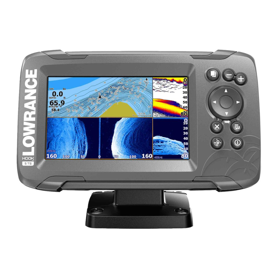
Front Controls
Identifies and describes the function of each physical button and control on the unit.
The Home Page
Explains how to access and navigate the main menu screen of the device.
Application Pages
Describes the different functional screens (applications) available on the device.
Basic Operation
System Controls and Power Management
Provides quick access to system settings, power, standby, and brightness.
Display Illumination and Menus
Guides on adjusting screen brightness, using night mode, and interacting with menus.
Cursor and Man Overboard Waypoint
Describes cursor use, screen capture, and how to mark a Man Overboard position.
Customizing Your System
Home Page Customization
Guides on changing the Home page wallpaper and displaying data overlays.
Custom Page Management
Provides steps to add, edit, delete custom pages, and adjust panel splits.
Charts
Chart Panel Overview
Describes the chart screen layout, types, vessel symbol, scale, and panning.
Navigation Features
Covers waypoints, routes, trails, navigation, displaying item info, and finding objects.
Chart Overlay and Orientation
Explains overlaying data, chart orientation, and look ahead settings.
C-MAP and Navionics Options
Details specific chart options for C-MAP and Navionics data.
GPS Plotter
GPS Plotter Display and Navigation
Describes the GPS plotter page, vessel symbol, scale, panning, and view options.
GPS View Options and Settings
Covers GPS overlay, waypoints, routes, trails, navigating, and plotter settings.
Waypoints, Routes, and Trails
Waypoint Management
Details managing waypoints: saving, moving, editing, and deleting.
Route Management
Explains creating, editing, and deleting navigation routes.
Trail Management
Describes tracking, converting, and managing recorded vessel paths (trails).
Navigating
Navigation Methods
Guides on navigating to cursor position, waypoints, and routes.
Navigation Settings
Covers settings like arrival radius, XTE limit, XTE alarm, and logging type.
Sonar
Sonar Image and Display Basics
Explains the sonar display, zoom, history, and basic customization.
Sonar Modes and Tuning
Details custom/ice fishing modes, range, frequency, sensitivity, and advanced options.
Advanced Sonar Options
Covers split screen, bottom lock, flasher, palettes, and fish ID features.
Sonar Data Recording and Settings
Guides on starting, stopping, viewing sonar logs, and sonar settings.
StructureScan
StructureScan Image and Display
Explains the StructureScan display, zoom, cursor usage, and history viewing.
Recording and Setup
Covers recording data, setting up the image, custom options, range, and contrast.
DownScan
DownScan Image and Display
Explains the DownScan display, zoom, cursor usage, and history viewing.
DownScan Settings and Customization
Covers custom mode options, range, frequency, contrast, and advanced settings.
StructureMap
StructureMap Image and Activation
Describes overlaying StructureScan data onto maps and activating the overlay.
StructureMap Data Management and Options
Covers tips, recording data, converting to format, mapping cards, and options.
Alarms
Alarm System and Message Types
Explains the alarm system, message colors, importance, and types.
Alarm Management and Dialogs
Describes alarm message display, acknowledgment, disabling, and alarm dialogs.
Tools
System Settings
Provides access to language, text size, key beeps, time, datum, coordinate, and magnetic variation settings.
Navigation, Chart, and Sonar Settings
Covers settings for navigation, chart display, and sonar functions.
Data Management Tools
Accesses waypoints/routes/trails, info (sun/moon/tides), and storage (file management).
Maintenance
Preventive Maintenance and Cleaning
Recommends basic care like using a sun cover and provides cleaning instructions.
Connector Checks
Guides on inspecting connectors for proper seating and alignment.
Simulator
Demo Mode and Source Files
Explains the automatic demo mode and how to select simulator data files.
Advanced Simulator Settings
Covers manual control of simulator parameters like GPS source, speed, and course.
Need help?
Do you have a question about the 7 TS and is the answer not in the manual?
Questions and answers