
Related Manuals for Eagle FishElite, SeaCharter 480, 480DF


Summarization of Contents
Section 1: Read Me First!
Capabilities and Specifications
Details about the unit's display, resolution, power, and general features.
Introduction to GPS and WAAS
Explains the principles of GPS and WAAS satellite navigation systems.
Section 2: Installation & Accessories
Transducer Installation
Instructions for mounting the sonar transducer on a transom, trolling motor, or inside a hull.
MMC or SD Card Memory Card Installation
Instructions for installing memory cards for data storage.
Section 3: Basic Sonar Operation
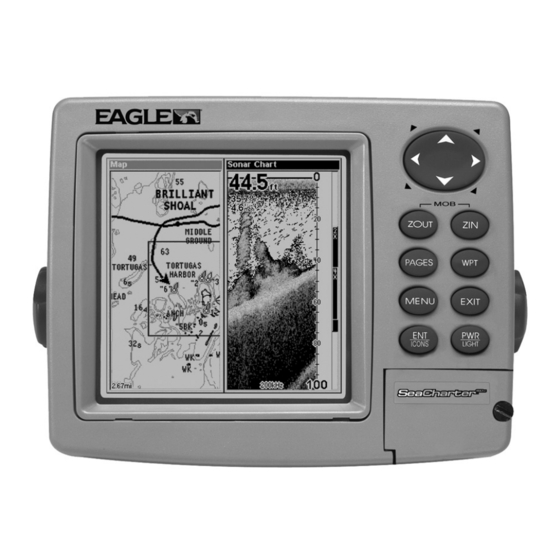
Keyboard
Overview of the unit's buttons and their functions for operation.
Basic Sonar Quick Reference
A simplified guide for quick sonar operation and fish finding.
Section 4: Sonar Options & Other Features
Alarms
Configuration of audible alarms for depth, zone, and fish detection.
Sensitivity & Auto Sensitivity
Adjusting sensitivity to optimize echo detection and reduce clutter.
Sonar Simulator
Using the built-in simulator to practice sonar features without going on the water.
Section 5: Sonar Troubleshooting
Weak bottom echo, digital readings erratic, or no fish signals
Diagnosing problems related to poor bottom echo or erratic readings.
Section 6: Basic GPS Operations
Find Your Current Position
Simple steps to acquire the unit's current GPS location.
Searching
Using the unit's powerful search functions for addresses, POIs, and exits.
Create Waypoint at Current Position
Saving the current location as a waypoint for future navigation.
Navigate To a Waypoint
Steps to select and navigate to a previously saved waypoint.
Section 8: System & GPS Setup Options
Coordinate System Selection
Choosing display formats for position coordinates like UTM, MGRS, and Lat/Lon.
Screen Contrast and Brightness
Adjusting display settings for optimal visibility.
Units of Measure
Setting units for speed, distance, depth, temperature, and heading.
Section 9: Searching
Find Addresses
Locating specific street addresses within the unit's database.
Find Map Places or Points of Interest (POI)
Searching for points of interest like restaurants, hotels, and landmarks.
Find Streets or Intersections
Locating streets and their intersections on the map.
Section 10: Supplemental Material
Datums Used by This Unit
A list of geodetic datums supported by the unit for position referencing.
Need help?
Do you have a question about the FishElite, SeaCharter 480, 480DF and is the answer not in the manual?
Questions and answers