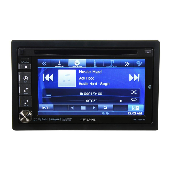
Alpine INE-S920HD User Manual
Navigation user's manual (english)
Hide thumbs
Also See for INE-S920HD:
- Owner's manual (116 pages) ,
- Manuel de l'utilisateur (91 pages) ,
- Manual de usuario (87 pages)

Related Manuals for Alpine INE-S920HD


Summary of Contents for Alpine INE-S920HD
-
Page 1: User Manual
User Manual Alpine Navigation Navigation software for the Alpine INE-S920HD/INE-Z928HD/INE-NAV-30/INE-NAV-38 US English (EN) - Page 2 Thank you for choosing the Alpine unit as your navigator. Start using your device right away. This document is the detailed description of the navigation software. You can easily discover the software while you are using it; however, we still recommend that you read this manual to fully understand the...
-
Page 3: Table Of Contents
Table of contents 1 Warnings and Safety information ................... 6 2 Getting started ........................... 7 2.1 Buttons and other controls on the screen ..................8 2.1.1 Using keyboards............................9 2.1.2 Beyond single screen tap........................... 10 2.2 Map screen ..........................11 2.2.1 Navigating on the map .......................... - Page 4 3.1.2.4 Searching for a Place of Interest by name ........................ 45 3.1.3 Using the free form search ........................48 3.1.4 Selecting a map location as the destination ....................49 3.1.5 Selecting the destination from your Address Book ................... 50 3.1.6 Selecting a recent destination from the History ..................51 3.1.7 Entering the coordinate of the destination ....................
- Page 5 5.3.6 Regional settings ............................81 5.3.7 Trip monitor settings ..........................81 5.4 Trip monitor ..........................82 6 Glossary ............................ 83 7 Copyright note ......................... 85...
-
Page 6: Warnings And Safety Information
1 Warnings and Safety information The navigation system helps you find your way to your destination with a connected GPS receiver. The software does not transmit your GPS position; others cannot track you. It is important that you look at the display only when it is safe to do so. If you are the driver of the vehicle, we recommend that you operate your software before you start your journey. -
Page 7: Getting Started
2 Getting started When using the navigation software for the first time, an initial setup process starts automatically. Do as follows: Select the written language of the application interface. Later you can change it in Regional settings (page 81). Read the End User License Agreement. Tap to continue. -
Page 8: Buttons And Other Controls On The Screen
If needed, modify the default route planning options. Later you can change them in Route settings (page 74). The initial setup is now complete. The Configuration wizard can be restarted later from the Settings menu (page 70). After the initial setup, the Map screen appears and you can start using the software. 2.1 Buttons and other controls on the screen When you are using the software, you usually tap buttons on the touch screen. -
Page 9: Using Keyboards
List When you need to select from Grab the list anywhere and several options, they appear in a slide your finger up or down. list. Depending on the speed of the sliding, the list will scroll fast or slow, only a bit or till the end. Alternatively, move between pages with the buttons and tap the... -
Page 10: Beyond Single Screen Tap
Correcting your entry on the keyboard to remove the unneeded character(s). Tap and hold the button to delete several characters or the entire input string. Entering a space, for example between a first name and a Tap the button at the bottom center of the screen. family name or in multi-word street names Entering upper and lower case... -
Page 11: Map Screen
Alpine unit audio system to appear on the other half. You can decide which side of the map is the navigation. Simply tap the audio part and drag it to the other side of the screen. - Page 12 When GPS position is available, the Vehimarker is displayed in full color, now showing your current position. There are screen buttons and data fields on the screen to help you navigate. During navigation, the screen shows route information. Two data fields are displayed on the left. The data fields are different when you are navigating an active route and when you have no specified destination (the orange line is not displayed).
- Page 13 : 3D perspective view rotated in your direction of travel. : 2D top-down view facing North. : 2D top-down view rotated in your direction of travel.
-
Page 14: Position Markers
2.2.2 Position markers 2.2.2.1 Vehimarker and Lock-on-Road When your GPS position is available, the software marks your current position with the Vehimarker. By default, this marker is a blue arrow, but you can change this icon in Settings. When on-road navigation is selected, the Vehimarker may not show your exact GPS position and heading. -
Page 15: Turn Preview And Next Street
2.2.3.2 Turn preview and Next street When navigating a route, the top section of the Map screen shows information about the next route event (maneuver) and the next street or the next city/town. There is a field in the top left corner that displays the next maneuver. Both the type of the event (turn, traffic circle, exiting freeway, etc.) and its distance from the current position are displayed. -
Page 16: Lane Information And Signposts
Approaching a waypoint. Approaching the destination. These fields also act as buttons: Tap the Turn preview field and the voice guidance will repeat the latest instruction with updated distance information. Tap the Next street field to open the Itinerary. 2.2.3.3 Lane information and Signposts When navigating on multilane roads, it is important to take the appropriate lane in order to follow the recommended route. -
Page 17: Freeway Exit Services
This feature can be turned off in Visual Guidance settings. 2.2.3.5 Freeway exit services You may need a gas station or a restaurant during your journey. This feature displays a new button on the map when you are driving on freeways. Tap this button to open a panel with the details of the next few exits or service stations. -
Page 18: Elements Of The Active Route
2.2.3.7 Elements of the active route Your software shows the route in the following way: Symbol Name Description Current GPS position and Start Your current position displayed on the map. If roads are point near, it is aligned to the nearest road. Normally if GPS position is available, the route starts from the current position. -
Page 19: Manipulating The Map
In the first column you can see the number of traffic events on your route. The second column contains the full count of traffic events in the categories. Tap any of the even types to list the event in that category or select the top row to open the list of all traffic events: Now tap any of the list items to see its details, and to display the affected road segment in its full length on the map:... - Page 20 Zooming in and out Changes how much of the map is displayed on the screen. Your software uses high-quality vector maps that let you examine the map at various zoom levels, always with optimized content. It always displays street names and other text with the same font size, never upside-down, and you only see the streets and objects that you need.
-
Page 21: Checking The Details Of The Current Position (Where Am I?)
2.2.5 Checking the details of the current position (Where Am I?) This screen contains information about the current position (or about the last known position if GPS reception is not available) and a button to search for useful Places nearby. You can access this screen from the map in one of the following ways: If the current street is displayed below the Vehimarker (the current position on the map), tap it to open the Where Am I? screen. -
Page 22: Navigation Menu
: Police stations : Gas stations Tap any of the buttons, select a Place from the list, and navigate to it. 2.3 Navigation menu You can reach all parts of the software from the Navigation menu. When you open the menu, the destination search buttons appear on the screen. -
Page 23: On-Road Navigation
3 On-road navigation When first started, Alpine unit calculates routes using the road network of the high quality vector maps provided with the product. You can set up your route in different ways: If you need a route for immediate navigation, you can select the destination and start navigating to it right away (normal navigation). -
Page 24: Entering An Address (United States)
any of the above, starting the search with the ZIP code (page 36) You can also search for an address with the free form search (page 48). 3.1.1.1 Entering an address (United States) To enter an address as the destination, do as follows: In the Navigation menu, tap the following buttons: By default, the software proposes the country and state where you are. - Page 25 Enter the street name: Start entering the street name on the keyboard. Find the street you need: The most likely street name is always shown in the input field. To accept it, tap If the desired name does not show up, the names that match the string appear in a list after entering a couple of characters (to open the list of results before it appears automatically, tap ).
-
Page 26: Entering An Address (Canada)
Tip! you know that will this destination frequently, before tapping to confirm the destination, put it in the Address Book first: tap then , give a name for the new entry, and tap to save the location. The map with the destination returns automatically. - Page 27 If the desired name does not show up, the names that match the string appear in a list after entering a couple of characters (to open the list of results before it appears automatically, tap ). Select the city/town from the list. Enter the street name: (if you have selected a city/town above, this step is not needed).
-
Page 28: Entering An Address (Mexico)
A full screen map appears with the selected point in the middle. If necessary, tap the map somewhere else to modify the destination. The Cursor ( ) appears at the new location. Tap to confirm the destination, or tap to select a different destination. - Page 29 The most likely city/town name is always shown in the input field. To accept it, tap If the desired name does not show up, the names that match the string appear in a list after entering a couple of characters (to open the list of results before it appears automatically, tap ).
-
Page 30: Entering An Address Starting With The Street Name (In The United States Only)
A full screen map appears with the selected point in the middle. If necessary, tap the map somewhere else to modify the destination. The Cursor ( ) appears at the new location. Tap to confirm the destination, or tap to select a different destination. - Page 31 Enter the street name: Start entering the street name on the keyboard. Find the street you need: The most likely street name is always shown in the input field. To accept it, tap If the desired name does not show up, the names that match the string appear in a list after entering a couple of characters (to open the list of results before it appears automatically, tap ).
-
Page 32: Entering The Midpoint Of A Street As The Destination
3.1.1.5 Entering the midpoint of a street as the destination You can navigate to the midpoint of a street if the house number is not available: In the Navigation menu, tap the following buttons: Select the country, state and city/town as described earlier (page 24). Enter the street name: (if you have selected a city/town above, this step is not needed). -
Page 33: Selecting An Intersection As The Destination
A full screen map appears with the selected point in the middle. If necessary, tap the map somewhere else to modify the destination. The Cursor ( ) appears at the new location. Tap to confirm the destination, or tap to select a different destination. - Page 34 Instead of entering the house number, tap . The midpoint of the street is selected as the destination. A full screen map appears with the selected point in the middle. If necessary, tap the map somewhere else to modify the destination. The Cursor ( ) appears at the new location.
-
Page 35: Selecting A City/Town Center As The Destination
3.1.1.7 Selecting a city/town center as the destination The city/town center is not the geometric center of the city/town but an arbitrary point the map creators have chosen. In towns and villages, it is usually the most important intersection; in larger cities, it is one of the important intersections. -
Page 36: Entering An Address With A Zip Code
to confirm the destination, or tap to select a different destination. After a short summary of the route parameters, the map appears showing the entire route. The route is automatically calculated. Tap to modify route parameters, or tap and start your journey. 3.1.1.8 Entering an address with a ZIP code All of the above address searching possibilities can be performed with entering the ZIP code instead of the city/town name. - Page 37 Enter the street name: Start entering the street name on the keyboard. Find the street you need: The most likely street name is always shown in the input field. To accept it, tap If the desired name does not show up, the names that match the string appear in a list after entering a couple of characters (to open the list of results before it appears automatically, tap ).
-
Page 38: Tips On Entering Addresses Quickly
After a short summary of the route parameters, the map appears showing the entire route. The route is automatically calculated. Tap to modify route parameters, or tap and start your journey. 3.1.1.9 Tips on entering addresses quickly When you are entering the name of a city/town or a street: Only those letters are offered on the keyboard that appear in possible search results. -
Page 39: Selecting The Destination From The Places Of Interest
3.1.2 Selecting the destination from the Places of Interest You can select your destination from the Places of Interest included with your software. Using the same screen, you can find a Place in different ways: with the Quick search feature, you can quickly find a nearby Place by its name with the Preset search feature, you can find frequently searched types of Places with only a few screen taps you can search for a Place by its category... -
Page 40: Searching For A Place Of Interest Using Preset Categories
(optional) The Places in the list are ordered by the length of the necessary detour (when navigating a route) or by their distance from the current position (when no destination is given). If you need to reorder the list, tap Browse the list if necessary and tap one of the list items. - Page 41 The preset search categories appear: If an active route exists, gas stations are searched along the route. If there is no active route (destination is not selected), they are searched around the current position. If the current position is not available either (no GPS signal), they are searched around the last known position.
-
Page 42: Searching For A Place Of Interest By Category
(optional) The Places in the list are ordered by their distance from the current or last known position, from the destination or by the length of the necessary detour. If you need to reorder the list, tap Browse the list if necessary and tap one of the list items. A full screen map appears with the selected point in the middle. - Page 43 to search for a place within a selected city/town. (The result list will be ordered by the distance from the center of the selected city/town.) to search for a place around the destination of the active route. (The result list will be ordered by the distance from the destination.) to search along the active route, and not around a given point.
- Page 44 Sometimes the list of brands in the selected Place subcategory appears. Select one brand or tap to list all Places in the selected subcategory around the selected location or along the route. Finally, the results appear in a list. (optional) The Places in the list are ordered by their distance from the current or last known position, from the selected city/town, from the destination or by the length of the necessary detour.
-
Page 45: Searching For A Place Of Interest By Name
13. After a short summary of the route parameters, the map appears showing the entire route. The route is automatically calculated. Tap to modify route parameters, or tap and start your journey. 3.1.2.4 Searching for a Place of Interest by name You can search for Places of Interest by their names. - Page 46 (optional) If you have selected , select the city/town to search in. Select one of the main Place categories (e.g. Accommodation) to search in or tap to search among all Places. Select one of the Place subcategories (e.g. Hotel or Motel) to search in or tap to search in the selected Place category.
- Page 47 Using the keyboard, start entering the name of the Place. After entering a few letters, tap to open the list of Places with names containing the entered character sequence. 10. (optional) The Places in the list are ordered by their distance from the current or last known position, from the selected city/town, from the destination or by the length of the necessary detour.
-
Page 48: Using The Free Form Search
3.1.3 Using the free form search A quick way to search for an address, a Place, an Address Book entry or a History item is to use the free form search. Do as follows: In the Navigation menu, tap Open the menu and tap In the left field enter the name you are looking for. -
Page 49: Selecting A Map Location As The Destination
to confirm the destination, or tap to select a different destination. After a short summary of the route parameters, the map appears showing the entire route. The route is automatically calculated. Tap to modify route parameters, or tap and start your journey. 3.1.4 Selecting a map location as the destination In the Navigation menu, tap the following buttons: Locate your destination on the map: move and scale the map as needed. -
Page 50: Selecting The Destination From Your Address Book
3.1.5 Selecting the destination from your Address Book You can select a location that you have already saved as an Address Book entry to be your destination. Adding a location to the Address Book is described on page 59. Access the Address Book: in the Navigation menu, tap and then tap The Address Book is displayed. -
Page 51: Selecting A Recent Destination From The History
3.1.6 Selecting a recent destination from the History The destinations that you have set earlier appear in the History. Access the History: If you are in the Navigation menu, tap and then tap The list of recent destinations appears. Smart History promotes three destinations to the first page based on your previous routes (most likely destinations). -
Page 52: Entering The Coordinate Of The Destination
3.1.7 Entering the coordinate of the destination You can also select a destination by entering its coordinate. Do as follows: In the Navigation menu, tap Open the menu and tap You can enter the latitude and longitude values in any of the following formats: decimal degrees; degrees and decimal minutes;... -
Page 53: Navigate To A Location Stored In A Picture
3.1.8 Navigate to a location stored in a picture You can also set the location stored in a picture as your destination. Do as follows: In the Navigation menu, tap Open the menu and tap The list of picutres stored on the microSD card appears. Select one picture from the list. A full screen map appears with the selected point in the middle. -
Page 54: Building A Route From The List Of Destinations (Create Route)
3.1.9 Building a route from the list of destinations (Create Route) You can also build your route destination by destination from the Route menu. In the Navigation menu, tap There is only one line in the list of route points, the start point of the route, normally the current GPS position. -
Page 55: Viewing The Entire Route On The Map
3.2 Viewing the entire route on the map It is easy to get a map overview of the active route. Do as follows: In the Navigation menu, tap . The active route is displayed in its full length on the map together with additional information and controls. -
Page 56: Setting A New Starting Position For The Route
to add the newly selected location as an intermediate destination to your route. The other destinations of the route remain intact. Note: the new waypoint is placed among destinations to keep the route optimal. To decide where a waypoint to appear, use the Edit Route feature. to append the newly selected destination at the end of the route. -
Page 57: Editing The List Of Destinations (Edit Route)
The Destination menu appears and you can select the start point of the route the same way you select a destination. When the new start point is set, tap The map returns with a transparent Vehimarker (showing that there is no GPS reception). If an active route already existed, it is now recalculated starting from the selected location. -
Page 58: Canceling The Active Route
to delete a destination. to modify the start point of the route. to reorder the list. You can do it manually or you can let the application optimize the route for you. 3.3.4 Canceling the active route To cancel the navigated route, tap in the Navigation menu, and then tap .. -
Page 59: Saving A Location As An Address Book Entry
Or if you cannot find a good alternative, tap and scroll down for routes with different routing methods. Select one of the route alternatives then tap to return to the Map screen. The software recalculates the route. The orange line now shows the new recommended route. 3.4 Saving a location as an Address Book entry You can add any location to the Address Book, the list of frequently used destinations. -
Page 60: Saving A Location As An Alert Point
3.5 Saving a location as an alert point You can save any map location as an alert point (for example a speed camera or a railroad crossing). Browse the map and select a location. The red Cursor appears there. Scroll down the list and tap On the newly opened screen, select the type of the alert point, the direction from which you expect the alert, and (if applicable) the speed limit for this alert point. -
Page 61: Watching The Simulation Of The Route
Scroll down the list and tap On the newly opened screen, modify the type of the alert point, the direction from which you expect the alert, or (if applicable) the speed limit for this alert point. to save the changes to the alert point. 3.7 Watching the simulation of the route You can run a simulated navigation that demonstrates the active route. - Page 62 (optional) You have the following controls during the simulation: : Jump to the next route event (maneuver). : Pause the simulation. : Jump to the previous route event (maneuver). : Tap to increase the speed of the simulation to 4, 8 or 16 times faster. Now tap again to return to the normal speed.
-
Page 63: Off-Road Navigation
4 Off-road navigation When first started, Alpine unit calculates routes using the road network of the high quality vector maps provided with the product. You can switch the application to off-road mode from the Navigation menu. Tap and then Most of the procedures described for on-road navigation also apply to off-road navigation. However, there are some that are not available in this navigation mode (for example you cannot open the itinerary as you have no maneuvers just route points and straight lines between them). -
Page 64: Reference Guide
5 Reference Guide On the following pages you will find the description of the different concepts and menu screens of the software. 5.1 Concepts 5.1.1 Smart Zoom Smart Zoom provides much more than just a usual automatic zoom feature: While following a route: when approaching a turn, it will zoom in and raise the view angle to let you easily recognize your maneuver at the next junction. - Page 65 Maneuver restrictions and directional constraints are taken into account when planning a route. Roads are used only if access for cars is allowed. Private roads and resident-only roads are used only if they are inevitable to reach the destination. Walkways are excluded from routes. All maneuvers are available in intersections.
-
Page 66: Green Routing
Whenever data exist, route calculation takes into account statistical traffic data for the given day of week and time of day. Real-time Traffic events are also taken into account and sometimes greatly modify the route. Your software automatically recalculates the route if you deviate from the proposed itinerary or if a newly received Traffic event concerns a part of the recommended route. -
Page 67: Speed Limit Warning
5.1.4 Speed limit warning Maps may contain information about the speed limits of the road segments. The software is able to warn you if you exceed the current limit. This information may not be available for your region (ask your local dealer), or may not be fully correct for all roads in the map. - Page 68 the FM radio stations for TMC data, and the decoded information will immediately be used in route planning. When your software receives traffic information that may affect your route, the program will warn you that it is recalculating the route, and navigation will continue with a new route that is optimal considering the most up-to-date traffic conditions.
-
Page 69: Information Menu
5.2 Information menu The Information menu provides you with various options and additional applications. In the Navigation menu, tap Button Description Tap this button to get information about the current location and to find nearby help. Tap this button to open the GPS Information screen with satellite position and signal strength information. -
Page 70: Settings Menu
Access travel applications: the unit converter helps you convert between various different international units for temperature, speed, area or pressure, etc. Access travel applications: the clothing size converter helps you convert between various different international size units for men's or women's cloth types and shoes. - Page 71 7. Delete all saved data and reset all settings to their factory defaults. Visit alpine.naviextras.com to get additional content, such as new maps or 3D landmarks and useful applications. The About section provides you with product information. Read the Software and Database End User License Agreement, or check the map and other contents of the application.
-
Page 72: Sound And Warnings
5.3.1 Sound and Warnings Adjust the sound volume, mute your device or change the voice guidance language. In addition, you can enable and set up different warnings and alerts. Button Description Tap this button to adjust the volume of the different sounds in the application. A new screen shows the different sound types and their controls. - Page 73 Maps may contain information about the speed limits of the road segments. The software is able to warn you if you exceed the current limit. This information may not be available for your region (ask your local dealer), or may not be fully correct for all roads in the map.
-
Page 74: Traffic Settings
5.3.2 Traffic settings The recommended route is not always the same between two points. Whenever suitable data exists, traffic information can be taken into account in the route calculation. Button Description Use this switch to enable or disable historical traffic data and traffic patterns. This locally stored information can be very useful in normal circumstances but for example on public vacations it may be better to turn off in order not to take into account normal weekday traffic jams. - Page 75 Excluding a road type is a preference. It does not necessarily mean total prohibition. If your destination can only be accessed using some of the excluded road types, they will be used but only as much as necessary. In this case a warning icon will be shown on the Route screen, and the part of the route not matching your preference will be displayed in a different color on the map.
- Page 76 When creating a new vehicle profile, first you need to select the vehicle type. Then you need to set the following parameters. You can modify the same parameters when you edit an existing profile: Button Description Tap this button to rename the profile for something meaningful. Enter the average consumption of your vehicle when used in built-up areas.
- Page 77 Maneuver restrictions and directional constraints are taken into account when planning a route. Roads are used only if access for buses is allowed. Private roads, resident-only roads and walkways are excluded from routes. Maneuver restrictions and directional constraints are taken into account when planning a route.
-
Page 78: Map Settings
5.3.4 Map settings You can fine-tune the appearance of the Map screen. Adjust the map view to your needs, choose suitable color themes from the list for both daytime and night use, change the blue arrow to a 3D car model, show or hide 3D buildings, turn track logging on or off, and manage you Place visibility sets (which Places to show on the map). -
Page 79: Visual Guidance Settings
Show or suppress 3D city models, 3D artistic or block representation of full city building data containing actual building size and position on the map. Turn on or off track log saving, that is, saving the sequence of the locations your journeys go through. - Page 80 When entering tunnels, the surface roads and buildings can be disturbing. This feature shows a generic picture of a tunnel instead of the map. A top-down overview of the tunnel and remaining distance are also displayed. Turn on the route progress bar to see your route as a straight line on the right side of the map.
-
Page 81: Regional Settings
5.3.6 Regional settings These settings allow you to customize the application for your local language, measurement units, time and date settings and formats, as well as to choose the time zone. Button Description This button displays the current written language of the user interface. By tapping the button, you can select a new language from the list of available languages. -
Page 82: Trip Monitor
5.4 Trip monitor If you save your trip logs when you arrive at some of your destinations or let the application automatically save the trip logs for you, those logs are all listed here. Tap one of the trips to see the trip statistics, speed and elevation profile. -
Page 83: Glossary
6 Glossary 2D/3D GPS reception The GPS receiver uses satellite signals to calculate its (your) position and needs at least four signals to give a three-dimensional position, including elevation. Because the satellites are moving and because objects can block the signals, your GPS device might not receive four signals. If three satellites are available, the receiver can calculate the horizontal GPS position but the accuracy is lower and the GPS device does not give you elevation data: only 2D reception is possible. - Page 84 Route A sequence of route events, i.e. maneuvers (for example, turns and traffic circles) to reach the destination. The route contains one start point and one or more destinations. The start point is the current (or last known) position by default. If you need to see a future route, the start point can be replaced with any other given point.
-
Page 85: Copyright Note
The product and the information contained herein are subject to change without prior notification. This manual may not, in whole or in part, be reproduced or transmitted in any form either electronically or mechanically, including photocopying and recording, without the express written consent of Alpine Electronics, Inc.
Need help?
Do you have a question about the INE-S920HD and is the answer not in the manual?
Questions and answers