dji AGRAS T30 Aircraft Flight Manual
Hide thumbs
Also See for AGRAS T30:
- User manual (132 pages) ,
- Quick start manual (99 pages) ,
- User manual (95 pages)

Related Manuals for dji AGRAS T30


Summary of Contents for dji AGRAS T30
- Page 1 AGRAS T30 Type: DJI-3WWDZ-30A Unmanned Aircraft Flight Manual v1.6 2022.9.29 Publication Number: DAT30-OA-UFM-001...
- Page 2 This document is copyrighted by DJI with all rights reserved. Unless otherwise authorized by DJI, you are not eligible to use or allow others to use the document or any part of the document by reproducing, transferring or selling the document.
-
Page 3: Table Of Contents
Takeoff/Landing Cruise / Maneuvering Flight System Shutdown Post-Flight Inspection Emergency Procedures General Information Engine Failure Fire Loss of C2 Link Loss of Navigation Systems Control Station Failures Flyaway Reporting Requirements Emergency Response Plan (ERP) © 2022 DJI All Rights Reserved. - Page 4 AGRAS T30 Unmanned Aircraft Flight Manual Weight and Balance and Equipment List Handling, Servicing and Instructions for Maintenance and Continued Airworthiness Ground Handling Disassembly, Storage, and Reassembly Charging / Conditioning / Replacing Batteries Maintenance Program Supplements Specifications Operation Resumption System Data Protection...
-
Page 5: General Information And System Description
The Agras T30 is DJI’s next-generation aircraft, boasting a revolutionary transforming structure and a max payload of up to 35 kg. Using DJI’s digital agriculture solutions, the performance and efficiency of crop protection operations can be greatly enhanced and improved. The updated Route Operation mode includes Connection Routing, which enables the aircraft to automatically fly to a task route and avoid obstacles that have been marked in field planning. -
Page 6: Aircraft
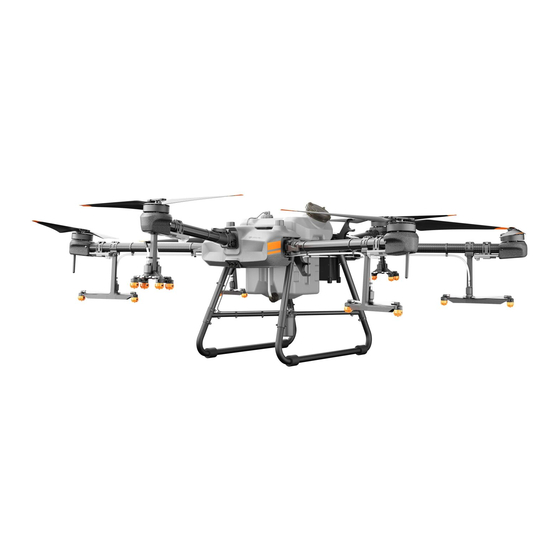
T30 to the Orchard configuration. When using the package and DJI's unique branch-targeting technology, the T30 can penetrate thick canopies for more precise and efficient spraying operations. * Must be used with a DJI D-RTK 2 High Precision GNSS Mobile Station (sold separately) or a DJI-approved Network RTK service. ©... - Page 7 AGRAS T30 Unmanned Aircraft Flight Manual Aircraft Overview Rear View Folded 1. Propellers 13. Heat Sinks 2. Motors 14. Liquid Level Gauge 3. ESCs 15. Spray Tank 4. Aircraft Front Indicators 16. Battery Compartment (on the M2 and M6 arms) 17.
- Page 8 D-RTK antennas. Dual-antenna technology provides strong resistance against magnetic interference. Communications Equipment The aircraft boasts two OcuSync antennas and DJI OcuSync Enterprise image transmission system, offering a maximum transmission range of 7 km for communication with the remote controller. FPV Module Equipped with dual FPV cameras, the T30 provides clear front and rear views and allows you to check the flight status without needing to turn the aircraft mid-flight.
- Page 9 AGRAS T30 Unmanned Aircraft Flight Manual the radar module can measure the spraying distance above the vegetation or other surfaces, but the aircraft is not able to fly at a constant spraying distance. Obstacle avoidance can be used in any mode.
- Page 10 10° at 1 m/s, 6° at 3 m/s, and 3° at 5 m/s. Maintain full control of the aircraft at all times and do not rely on the radar module and DJI Agras app. Keep the aircraft within VLOS (visual line of sight) at all times. Use your discretion to operate the aircraft manually to avoid obstacles.
-
Page 11: Control Station
The Smart Controller Enterprise (remote controller) is used as a control station. The remote controller uses the DJI OcuSync Enterprise image transmission system, which has a maximum control distance of up to 7 km (4.35 mi)*. It includes a dedicated, Android-based display that runs DJI Agras independently for operation planning and aircraft status display. - Page 12 AGRAS T30 Unmanned Aircraft Flight Manual Remote Controller Overview 17 18 1. Antennas 8. Battery Level LEDs Relays aircraft control and image transmission Displays current battery level of the internal signal. battery. 2. Back Button / Function Button 9. 5D Button (customizable) Press once to return to the previous page Hold 10.
- Page 13 Used to connect devices such as an RTK customize the button. Dongle, or to connect to a computer to update firmware and export logs via the DJI 25. Battery Cover Assistant 2 software. Open the cover to mount or remove the Intelligent Battery from the remote controller.
- Page 14 Power Outlet (100 - 240 V) Use an official DJI USB charger to charge the remote controller. If not, a USB charger certified FCC/CE rated 12 V/2 A is recommended. The battery will deplete when stored for an extended period of time. Recharge the battery at least once every three months to prevent over discharging.
- Page 15 AGRAS T30 Unmanned Aircraft Flight Manual External Battery Charge the external Intelligent Battery using the included AC power adapter and charging hub. 1. Place the battery into the charging hub, connect the AC power adapter to the charging hub, and connect the charger to a power outlet (100-240 V, 50/60 Hz).
- Page 16 AGRAS T30 Unmanned Aircraft Flight Manual Operating the Aircraft This section explains how to control the orientation of the aircraft through the remote controller. Control can be set to Mode 1, Mode 2, or Mode 3. Mode 1 Left Stick...
- Page 17 AGRAS T30 Unmanned Aircraft Flight Manual For example, the following description uses Mode 2: Remote Controller Aircraft ( Indicates nose Remarks (Mode 2) direction) Throttle Stick: Move the left stick vertically to control the elevation of the aircraft. Push up to ascend and push down to descend.
- Page 18 In Manual operation mode, press to start or stop spraying. 3. FPV / Map Switch Button In Operation View in DJI Agras, press to switch between FPV and the Map View. 4. Button C1 When planning a field, press the button to switch between Obstacle mode and Waypoints mode. The function of the button cannot be customized while planning a field.
- Page 19 Position P 位置P Regardless of the position the switch is in on the remote controller, the aircraft begins in P-mode by default. To switch flight modes, first go to Operation View in DJI Agras, tap , then , and enable “Enable Attitude Mode”...
- Page 20 AGRAS T30 Unmanned Aircraft Flight Manual Optimal Transmission Zone When the angle between the antennas and the back of the remote controller is 80° or 180°, the connection between the remote controller and aircraft can reach its optimal performance. 80°...
- Page 21 Power on the remote controller. Swipe down from the top of the screen, tap , then Notifications, and enable Do Not Disturb. After this, all the third-party notifications will be displayed in the notification bar only when the DJI Agras app is in use. Remote Controller LEDs Status LED Battery Level Indicators The battery level indicators display the battery level of the controller.
- Page 22 LED is solid green, this error may be related to the aircraft or flight status, and a warning will appear in DJI Agras. If this error is related to the remote controller, a warning will appear on the screen of the remote controller.
- Page 23 Execute Operation 1. Task Management : view planned fields, operation progress, and resources such as prescription maps. You can synchronize the local data with the data on the DJI AG platform. 2. User Info : view account information. 3. Aircraft Info : view the information of the connected aircraft such as the firmware version.
- Page 24 AGRAS T30 Unmanned Aircraft Flight Manual 11. Firmware Notifications : shows the firmware update notifications. Tap to enter the firmware page. 12. Aircraft Connection Status : shows if the aircraft is connected to the remote controller. 13. Plan Field | Execute Operation Plan Field: tap the button and select the planning method to plan a field.
- Page 25 AGRAS T30 Unmanned Aircraft Flight Manual 5. RTK/GNSS Signal Strength : this icon is displayed when RTK is enabled and works normally. On the upper right corner is the number of satellites connected. One of the following three statuses is displayed above the RTK icon: FIX indicates that the differential data calculation is completed and the aircraft can use RTK for positioning.
- Page 26 AGRAS T30 Unmanned Aircraft Flight Manual 10. Map Mode : tap to switch between Standard, Satellite, or Night modes. 11. Location Follow Tap to choose if the map display follows the aircraft location. : to keep the aircraft centered in the map.
-
Page 27: Command And Control Link
The actual parameters that can be adjusted vary depending on the operation mode. Command and Control Link The command and control (C2) link between the aircraft and remote controller is established using DJI OcuSync Enterprise transmission technology with the two OcuSync antennas on the aircraft and DJI OcuSync Enterprise image transmission system, offering a maximum transmission range of 7 km. -
Page 28: Performance And Limitations
7. Use this product to defame, abuse, harass, stalk, threaten, or otherwise violate the legal rights of others, such as the right of privacy and publicity. 8. Trespass onto private property of others. © 2022 DJI All Rights Reserved. -
Page 29: Center Of Gravity Limitations
AGRAS T30 Unmanned Aircraft Flight Manual Center of Gravity Limitations 1. Using the M1 motor shaft as a reference, the aircraft center of gravity in the front-to-back direction should be between 855-935 mm from the reference. 2. Using the lowest point of the aircraft as a reference, the aircraft center of gravity in the vertical direction should be between 527-567 mm from the reference. -
Page 30: Applicable Environmental Limitations
AGRAS T30 Unmanned Aircraft Flight Manual Applicable Environmental Limitations 1. DO NOT use the aircraft in adverse weather conditions such as winds exceeding 6 m/s, rain, snow, or fog. 2. Aircraft and battery performance is subject to environmental factors such as air density and temperature. -
Page 31: Normal Procedures
7. DO NOT fly more than 3000 m above sea level. 8. The DJI Agras app will intelligently recommend the payload weight limit for the tank according to the current status and surroundings of the aircraft. Do not exceed the recommended payload weight limit when adding material to the tank. - Page 32 If the aircraft loses GNSS signal and flies out of the max radius but regains GNSS signal later, it will fly back within range automatically. GEO Zones GEO zones are divided into different categories. All GEO zones are listed on the DJI official website at http://www.dji.com/flysafe. GEO zones are explained below (GNSS required): Depending on the local regulation, a certain radius around a marker forms a Restricted Zone, inside of which takeoff and flight are prohibited.
-
Page 33: Operational Limitation Complying With Anac Class 2 Crop Spraying Uas Regulations
AGRAS T30 Unmanned Aircraft Flight Manual With a strong GNSS signal Area Restriction Motors will not start. Restricted Zone If the aircraft loses GNSS signal and enters a Restricted Zone but regains GNSS signal later, the aircraft will enter semi-automatic descent after a countdown and land. -
Page 34: Use Of Launch And Recovery Equipment
AGRAS T30 Unmanned Aircraft Flight Manual Users still have to follow the guidance below when using the T30. 1. Avoid using wireless devices that use the same frequency bands as the remote controller. 2. When using with multiple aircraft, including T30, T10 and other aircraft, make sure that the distance between each aircraft is more than 10 m to avoid interference. - Page 35 Mounting the 4G Dongle and SIM Card Only use a DJI-approved dongle. The dongle supports various network standards. Use a SIM card that is compatible with the chosen mobile network provider and select a mobile data plan according to the planned level of usage.
-
Page 36: Pre-Flight Inspection Check
Dongle Reattach the cover firmly. * Test procedure: press the remote controller power button and press again and hold to power on the remote controller. In DJI Agras, tap , and select Network Diagnostics. The dongle and SIM card are functioning properly if the status of all the devices in the network chain are shown in green. -
Page 37: System Starting
2. Press the power button on the Intelligent Flight Battery and then press and hold to power on the aircraft. 3. Check the home screen in DJI Agras to make sure that the aircraft is connected to the remote controller. - Page 38 AGRAS T30 Unmanned Aircraft Flight Manual When to Recalibrate 1. Installing a different nozzle model. Note: Choose the corresponding model in the app after replacing nozzles. Go to Operation View, tap , then for configuration. 2. Using a liquid of a different viscosity.
-
Page 39: Takeoff/Landing
AGRAS T30 Unmanned Aircraft Flight Manual Takeoff/Landing The Combination Stick Command (CSC) listed below is used to start and stop the motors. Make sure you perform the CSC in one continuous motion. The motors begin to accelerate at an idle speed. -
Page 40: Cruise / Maneuvering Flight
AGRAS T30 Unmanned Aircraft Flight Manual Cruise / Maneuvering Flight Operating the Aircraft This section explains how to control the orientation of the aircraft through the remote controller. Control can be set to Mode 1, Mode 2, or Mode 3. - Page 41 AGRAS T30 Unmanned Aircraft Flight Manual For example, the following description uses Mode 2: Remote Controller Aircraft ( Indicates nose Remarks (Mode 2) direction) Throttle Stick: Move the left stick vertically to control the elevation of the aircraft. Push up to ascend and push down to descend.
- Page 42 Import prescription maps to the remote controller first in order to perform variable rate fertilization. 1. Store the prescription tasks planned in DJI Terra to a microSD card. 2. Insert the microSD card to the remote controller, go to the home screen in DJI Agras. Select the files in the prompted window and import.
- Page 43 Make sure that the aircraft is powered off when planning your flight route. 1. Power on the remote controller and enter DJI Agras. Tap Plan Field and select Walk with RC. 2. Wait until the GNSS signal is strong. Positioning accuracy may vary by +/-2 meters. Complete the remaining steps by walking with the remote controller following the same instructions as the Walk with RTK section.
- Page 44 Walk with RTK section. DJI Terra 1. Make sure to read the DJI Terra User Manual for field planning before sharing the planned data to DJI AG platform or storing the data to the microSD card in the remote controller.
- Page 45 6. Tap Back, then Done, name the operation, choose crop, and configure other parameters. Performing an Operation 1. Power on the remote controller and aircraft. 2. Go to the home screen in DJI Agras and tap Execute Operation to enter the Operation View. 3. Tap to select a field in Fields tag.
- Page 46 AGRAS T30 Unmanned Aircraft Flight Manual Only take off in open areas and set an appropriate auto-takeoff height according to the operating environment. The operation is automatically cancelled if the motors are started before beginning the operation. You will need to recall the operation in the task list.
- Page 47 AGRAS T30 Unmanned Aircraft Flight Manual Operation Route The aircraft travels along a planned square zig-zag route after recording turning points A and B. Under optimal working conditions, the obstacle avoidance and auto obstacle circumvention functions are available and the aircraft maintains the same distance from the vegetation. The length of the dotted lines, called route spacing, can be adjusted in the app.
- Page 48 AGRAS T30 Unmanned Aircraft Flight Manual 1. Enter A-B operation mode Go to Operation View in the app, tap the operation mode switch button in the upper left corner, and select A-B operation mode. 2. Record Points A and B in order Fly the aircraft to the starting point, depicted as Point A or B, hover, and tap Point A or B onscreen or press the preset customizable button on the remote controller.
- Page 49 AGRAS T30 Unmanned Aircraft Flight Manual If, after recording Points A and B, you fly the aircraft more than five meters away from Point B, Resume appears at the lower right corner of the screen. Tap Resume, and the aircraft automatically flies to Point B to perform the operation.
-
Page 50: System Shutdown
AGRAS T30 Unmanned Aircraft Flight Manual System Shutdown After landing, push the throttle stick down and hold to stop the motors. Press the power button and then press and hold to power off the aircraft and remote controller. Post-Flight Inspection 1. -
Page 51: Emergency Procedures
Home Point: The default home point is the first location where your aircraft received strong GNSS signals . Note that the white GNSS icon requires at least four bars before the signal is strong. RTH: RTH brings the aircraft back to the last recorded home point. © 2022 DJI All Rights Reserved. - Page 52 AGRAS T30 Unmanned Aircraft Flight Manual Failsafe RTH The aircraft will RTH or hover if the remote controller signal is lost. The action can be set in the app. Failsafe RTH will only be available if RTH is set. Failsafe RTH is automatically activated if the remote controller signal is lost for more than three seconds,...
-
Page 53: Loss Of Navigation Systems
GNSS signal. Reporting Requirements Users are responsible to inform DJI of any event of an uncontrolled crash or flyaway within 2 business days through DJI Support, a DJI authorized dealer, or other means and shall upload the flight data related to the event. See the instructions of flight data upload from https://youtu.be/X8sVce69z5g... -
Page 54: Emergency Response Plan (Erp)
AGRAS T30 Unmanned Aircraft Flight Manual Emergency Response Plan (ERP) In the event of incident or accident involving the DJI Agras drones, the Emergency Response Plan below must be followed: IN CASE OF ACCIDENT WITH VICTIMS CONTACT SAMU (MOBILE EMERGENCY CARE SERVICE) …........…... -
Page 55: Weight And Balance And Equipment List
T-shaped connector on the spray tank, detach the T-shaped connector, and attach the stopper to the hoses on the aircraft. c. Lift and remove the spray tank on the aircraft. © 2022 DJI All Rights Reserved. - Page 56 AGRAS T30 Unmanned Aircraft Flight Manual 3. Reattach the bottom cover of the aircraft firmly and make sure that there is no gap between the structures. Reassembly Follow the reverse operations of the disassembly steps above. Propellers Disassembly 1. Remove the two M5×15 propeller blade screws using a proper hex key.
- Page 57 AGRAS T30 Unmanned Aircraft Flight Manual Reassembly Identify the CW or CCW marks on the propeller blades and motors. Make sure to assemble the parts with the same mark. 1. Place the one rubber washer and then two Teflon gaskets onto one of the mounting hole on the motor.
-
Page 58: Charging / Conditioning / Replacing Batteries
AGRAS T30 Unmanned Aircraft Flight Manual If storing the battery for more than three months, it is recommended to store the battery in a battery safety bag in an environment at a temperature range from -20° to 40° C (-4° to 104° F). -
Page 59: Maintenance Program
If you have any problems or questions, contact DJI Support or a DJI authorized dealer. 2. DO NOT attempt to repair the aircraft if any parts are damaged. Contact DJI Support or a DJI authorized dealer for professional maintenance services. The T30 Drone Recommended Maintenance Cycle table in the Supplements section lists the recommended maintenance cycle and item maintenance performed by DJI authorized dealers only. -
Page 60: Supplements
Power Consumption 12 W Transmission Power (EIRP) SRRC: ≤13 dBm, NCC/MIC/KCC/CE/FCC: ≤20 dBm Altitude Detection & Terrain Follow Altitude detection range: 1-30 m Stabilization working range: 1.5-15 m Max slope in Mountain mode: 35° © 2022 DJI All Rights Reserved. - Page 61 AGRAS T30 Unmanned Aircraft Flight Manual Obstacle Avoidance Obstacle sensing range: 1.5-30 m FOV: Horizontal: 360°, Vertical: ±15° Working conditions: flying higher than 1.5 m over the obstacle at a speed lower than 7 m/s Safety limit distance: 2.5 m (distance between the front of propellers and...
- Page 62 AGRAS T30 Unmanned Aircraft Flight Manual Max Operating Speed 7 m/s Max Flying Speed 10 m/s (with strong GNSS signal) Max Wind Resistance 6 m/s Max Service Ceiling Above Sea Level 3000 m Recommended Operating Humidity <93% Recommended Operating 0° to 45° C (32° to 113° F)
- Page 63 AGRAS T30 Unmanned Aircraft Flight Manual Remote Controller Intelligent Battery Model WB37-4920mAh-7.6V Battery Type 2S LiPo Capacity 4920 mAh Voltage 7.6 V Energy 37.39 Wh Charging Environment Temperature 5° to 40° C (41° to 104° F) Intelligent Battery Charging Hub...
-
Page 64: Operation Resumption
AGRAS T30 Unmanned Aircraft Flight Manual Operation Resumption When exiting a Route or an A-B Route operation, the aircraft records a breakpoint. The Operation Resumption function allows you to pause an operation temporarily to refill the spray tank, change the battery, or avoid obstacles manually. - Page 65 AGRAS T30 Unmanned Aircraft Flight Manual Typical Applications In Route or A-B Route operation mode, users can control the aircraft forward, backward, and sideward, avoiding obstacles along the operation route, or in an emergency such as when the aircraft is experiencing abnormal behavior.
-
Page 66: System Data Protection
AGRAS T30 Unmanned Aircraft Flight Manual System Data Protection In Route or A-B Route operation mode, the System Data Protection feature enables the aircraft to retain vital system data such as operation progress and breakpoints after the aircraft is powered off to replace a battery or refill the spray tank. -
Page 67: Low Battery And Low Voltage Warnings
Refer to Emergency Procedures for more information about Failsafe RTH. Updating the Home Point You can update the home point in DJI Agras during flight. There are two ways to set a home point: 1. Set the current coordinates of the aircraft as the home point. -
Page 68: Rtk Functions
When there is a strong GNSS signal, the dual antennas activates automatically to measure the heading of the aircraft. The T30 supports centimeter-level positioning to improve agricultural operation when used with the DJI D-RTK 2 Mobile Station. Follow the instructions below to use the RTK functions. -
Page 69: Aircraft Status Indicators Description
Wi-Fi or a dongle. The firmware file is usually large. It is recommended to use Wi-Fi. 2. A prompt appears at the bottom of the home screen in DJI Agras when a new firmware update is available. Tap the prompt to enter the firmware screen. -
Page 70: Dji Assistant 2 For Mg
Configure settings of the basic parameters, copy flight records, and update aircraft and remote controller firmware in DJI Assistant 2 for MG. Installation and Launching 1. Download the DJI Assistant 2 for MG installation file from the T30 download page: https://www.dji.com/t30/downloads 2. Install the software. -
Page 71: Intelligent Flight Battery
AGRAS T30 Unmanned Aircraft Flight Manual Firmware Update A DJI account is required for firmware updates. Login or register an account. Exporting Log View all the logs of the remote controller and select the logs to export. DO NOT power off the remote controller during the update. - Page 72 Make sure the battery is correctly connected. Otherwise, the battery may overheat or even explode due to abnormal charging. Only use approved batteries from authorized dealers. DJI assumes no responsibility for any damaged caused by using batteries that are unapproved.
- Page 73 AGRAS T30 Unmanned Aircraft Flight Manual Make sure the battery is fully charged before each flight. Immediately land the aircraft if a critical battery level warning appears and replace with a fully charged battery. Before operating in a low-temperature environment, make sure the battery is at least above 5°...
- Page 74 Power button to turn the battery off, unplug the battery from the charging device, and then plug it back in to resume charging. DJI does not take any responsibility for damage caused by third-party charging devices. DO NOT charge the battery near flammable materials or on flammable surfaces such as carpet or wood.
- Page 75 AGRAS T30 Unmanned Aircraft Flight Manual The battery stops charging when charging is complete. It is recommended to disconnect the battery once charging is complete. Make sure the battery is powered off before charging. Otherwise, the battery ports may be damaged.
-
Page 76: Payload - Spraying System
Users can configure spreading settings in the DJI Agras app and create specific templates for different materials in order to meet different requirements. The app also provides warning prompts for an empty tank as well as for abnormalities in rotational speed, temperature, and hopper outlet size. - Page 77 AGRAS T30 Unmanned Aircraft Flight Manual Installation Make sure to remove the Intelligent Flight Battery from the aircraft before installation. Operate with caution to avoid injury caused by sharp or moving mechanical parts. 1. Remove the bottom cover on the front of the aircraft. Pry the bottom cover from the gap between the bottom cover and the rest of the aircraft using a tool if required.
- Page 78 AGRAS T30 Unmanned Aircraft Flight Manual 3. Insert the spreading system into the aircraft. The spreading system needs to be inserted at an angle. Do not insert by force. 4. Insert the spreading system cable to the cable strainer at the bottom of the aircraft and connect it to the 12-pin port inside of the aircraft after detaching the cover on the port.
- Page 79 6. Power off the aircraft and remount the spinner disk. Spreading Operations 1. Power on the remote controller and then the aircraft. Enter Operation View in the DJI Agras app. 2. Open the cover, add compatible material, and close the cover. The DJI Agras app will intelligently recommend the payload weight limit for the spread tank according to the current status and surroundings of the aircraft.
- Page 80 AGRAS T30 Unmanned Aircraft Flight Manual 3. Select the operation mode or use a planned field. 4. Tap on the left of the screen to enter Spreading Settings. 5. In Route, A-B Route, or Manual Plus operation mode, select a template for the spreading material and set parameters such as the material amount, spinner disk speed, flight speed, line spacing, and height relative to the vegetation.
- Page 81 DJI website. [2] The DJI Agras app will intelligently recommend the payload weight limit for the spread tank according to the current status and surroundings of the aircraft. Do not exceed the recommended payload weight limit when adding material to the spread tank.
-
Page 82: T30 Drone Recommended Maintenance Cycle
AGRAS T30 Unmanned Aircraft Flight Manual T30 Drone Recommended Maintenance Cycle Recommended replacement Part for service Module Recommended service time cycle 1. Carry out the first inspection for a new drone after 100 flights. 2. Carry out an inspection every 100 flight... - Page 83 AGRAS T30 Unmanned Aircraft Flight Manual Landing gear Replacement after 1,000 Radar Fixing components - Every 100h flight hours of usage is Bracket fixing bracket recommended. Spraying System - Replace the engine oil after Delivery Pump Every 100 flight hours Delivery Pump 300 flight hours of usage.
- Page 84 AGRAS T30 Unmanned Aircraft Flight Manual Replacement after 36 Radar System - Upward Radar Every 6 months months of usage is Upward Radar recommended. Power System - Power Replacement after 36 Power Distribution Distribution Every 6 months months of usage is...
-
Page 85: Certificate Of Equipment Authorization
Anatels Rules and Regulations. Type - Category: Transceptor de Radiação Restrita - II Model - Comercial Name (s) 3WWDZ-10A - (Agras T10) /3WWDZ-30A - (Agras T30) Basic technical characteristics: Faixa de Frequências Tx (MHz) Potência Máxima de Saída (W) Designação de Emissões... - Page 86 DJI Support http://www.dji.com/support This content is subject to change without prior notice. AGRAS is a trademark of DJI. Copyright © 2022 DJI All Rights Reserved.
Need help?
Do you have a question about the AGRAS T30 and is the answer not in the manual?
Questions and answers