dji AGRAS T16 User Manual
Hide thumbs
Also See for AGRAS T16:
- Quick start manual (39 pages) ,
- Quick start manual (21 pages) ,
- User manual (123 pages)
Table of Contents
Advertisement
Advertisement
Table of Contents

Related Manuals for dji AGRAS T16


Summary of Contents for dji AGRAS T16
- Page 1 AGRAS T16 User Manual v1.0 2019.10...
- Page 2 Searching for Keywords Search for keywords such as “battery” and “install” to find a topic. If you are using Adobe Acrobat Reader to read this document, press Ctrl+F on Windows or Command+F on Mac to begin a search. Navigating to a Topic View a complete list of topics in the table of contents.
-
Page 3: Information
4. User Manual Refer to the Agras T16 In the Box to check the listed parts and read the disclaimer and safety guidelines before flight. Refer to the quick start guide for more information on assembly and basic operation. Refer to the user manual for more comprehensive information. -
Page 4: Safety At A Glance
There is nothing obstructing the motors and propellers. • Spraying system is not blocked and works properly. • Compass is calibrated after being prompted to do so in the app. © 2019 DJI All Rights Reserved. - Page 5 Failsafe RTH automatically due to remote controller signal loss. • Maintain full control of the aircraft at all times and do not rely on the DJI MG2 app. The obstacle avoidance function is disabled in certain situations. Keep the aircraft within VLOS and pay close attention to its flight.
- Page 6 DO NOT use the aircraft in adverse weather conditions such as winds exceeding 28 kph (17 mph), heavy rain (precipitation rate exceeding 25 mm (0.98 in) in 12 hours), fog, snow, lightning, tornadoes, or hurricanes. GEO Zones Stay away from the rotating Learn more at: propellers and motors. http://www.dji.com/flysafe © 2019 DJI All Rights Reserved.
-
Page 7: Table Of Contents
Contents Information Using This Manual Legend Before Flight Downloading DJI Assistant 2 for MG Safety at a Glance Product Profile Introduction Feature Highlights Preparing the Aircraft Preparing the Remote Controller Aircraft Overview Remote Controller Overview Aircraft Aircraft Profile Flight Modes... - Page 8 Calibrating the Spraying System Calibrating the Compass Starting and Stopping the Motors Flight Test DJI Assistant 2 for MG Installation and Launching Using DJI Assistant 2 for MG Appendix Specifications Aircraft Status Indicators Description Updating the Firmware © 2019 DJI All Rights Reserved.
-
Page 9: Product Profile
4 RTK and DJI Terra to plan 3D flight routes, and import the routes to DJI MG2 for operation. * This must be used with a DJI D-RTK 2 High Precision GNSS Mobile Station (sold separately) or a DJI-approved Network RTK service. -
Page 10: Preparing The Aircraft
AGRAS T16 User Manual In A-B Route operation mode, the aircraft travels along a planned route and sprays its liquid payload. Users can set the line spacing, flying speed, and other parameters. In Manual operation mode, users can start and stop spraying manually and also adjust the spray rate. -
Page 11: Preparing The Remote Controller
Mounting the Dongle and SIM Card Only use a DJI-approved dongle. The dongle supports various network standards. Use a SIM card that is compatible with the chosen mobile network provider, and select a mobile data plan according to the planned level of usage. - Page 12 AGRAS T16 User Manual Lift the dongle compartment cover at the gap at its lower right corner, then remove it. Insert the dongle into the USB port with the SIM card inserted into the dongle, and test it. * Dongle Reattach the cover.
-
Page 13: Aircraft Overview
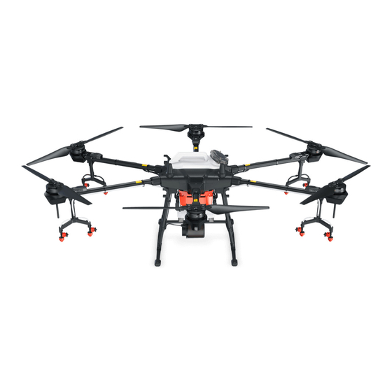
AGRAS T16 User Manual Aircraft Overview Aircraft Front Bottom View Folded 1. Propellers 13. Flow Meter 2. Motors 14. Delivery Pumps 3. ESCs 15. DBF Imaging Radar 4. Frame Arms 16. Landing Gear 5. Aircraft Front LEDs 17. Spray Tank (on the three front arms) 18. -
Page 14: Remote Controller Overview
Audio output. extra storage. 5. Lanyard Attachment 11. Display Device Used to attach the remote controller Android-based device to run DJI MG2. lanyard. 12. Sleep/Wake Button 6. Status LED Press to sleep or wake the screen. Press and Indicates whether the remote controller is hold to restart. - Page 15 AGRAS T16 User Manual 14. Spray Rate Dial 20. Button C1 Turn to adjust the spray rate in Manual When planning a field, press the button operation modes. to start or end obstacle measurement. The function of the button cannot be 15.
-
Page 16: Aircraft
Auto Bypass. Functions such as operation resumption, system data protection, empty tank warning, low battery level warning, and RTH are also available. When using your T16 for the first time, activate it in DJI MG2. A DJI account and internet connection are required. - Page 17 Make sure that the aircraft is powered off when planning your flight route. 1. Power on the remote controller and enter DJI MG2. Tap Field Plan and select Walk with RC. 2. Wait until the GNSS signal is strong. The satellite count should be no less than 10. Positioning accuracy may vary by +/-2 meters.
- Page 18 Fly the Aircraft section. DJI Terra 1. Make sure to read the DJI Terra User Manual for field planning before sharing the planned data to DJI AG Platform or storing the data to the microSD card in the remote controller.
- Page 19 1. Power on the remote controller. Place the aircraft at one of the previously set calibration points and power it on. 2. Go to the home screen in DJI MG2 and tap Execute Operation to enter the Operation View. 3. Tap to select a field in Fields tag, and tap Invoke.
- Page 20 DJI MG2 displays the line spacing icon after Point A and B are recorded. Tap to adjust the value. Line spacing cannot be adjusted during operation. Switch to Manual operation mode to adjust the value, then go back to A-B Route operation mode.
- Page 21 0.3 m/s, the data for Points A and B of the current route is erased and the aircraft hovers in place. Line spacing can be customized from 3-10 m in DJI MG2. It is set to a length of 5 m by default.
-
Page 22: Operation Resumption
Tap the operation mode switch button in the app and select M+ to enter Manual Plus operation mode. In this mode, the maximum flying speed of the aircraft is 7 m/s (customizable in DJI MG2), the heading is locked, and all other movement can be manually controlled. Users can disable the M+ heading lock in the app. - Page 23 4. Return Route There will be prompt in DJI MG2. Users can select from returning to the breakpoint or returning to the operating route at the nearest possible junction by following a perpendicular line.
-
Page 24: System Data Protection
3. Resuming Operation Tap Resume in DJI MG2. If the aircraft is in the operating area, there will be a prompt in DJI MG2. Select among the three project points E1, E2, or E3. The aircraft flies from Point D to the selected project point following a perpendicular line. -
Page 25: Dbf Imaging Radar
AGRAS T16 User Manual DBF Imaging Radar Profile The all-new DBF imaging radar works during both day and night, without being affected by light or dust. In an optimal operating environment, the radar module can predict the distance between the aircraft and the vegetation or other surfaces in forward, rear, and downward directions to fly at a constant distance to ensure even spraying and terrain following capability. - Page 26 Avoidance During RTH (p. 27) for more information. Altitude Stabilization Function Usage 1. Make sure that you have enabled the altitude stabilization function of the radar module in DJI MG2. 2. Enter the desired operation mode, and configure the desired spraying distance.
-
Page 27: Empty Tank
Profile A prompt appears in DJI MG2 and the aircraft hovers in place when the spray tank is empty. In Route, A-B Route, and Manual Plus operation modes the aircraft can also be set to ascend or RTH instead of hovering. - Page 28 Blinks green slowly Updating the Home Point You can update the home point in DJI MG2 during flight. There are two ways to set a home point: 1. Set the current coordinates of the aircraft as the home point. 2. Set the current coordinates of the remote controller as the home point.
-
Page 29: Low Battery And Low Voltage Warnings
Users can only control the speed and altitude of the aircraft. Before each flight, it is important to set an RTH altitude that is appropriate for the given environment. Go to Operation View in DJI MG2, tap , then , and Set Return to Home Altitude. -
Page 30: Rtk Functions
When there is a strong GNSS signal, the dual antennas activates automatically to measure the heading of the aircraft. The T16 supports centimeter-level positioning to improve agricultural operation when used with the DJI D-RTK 2 Mobile Station. Follow the instructions below to use the RTK functions. -
Page 31: Remote Controller
Remote Controller Profile The remote controller uses the DJI OcuSync 2.0 dual-band image transmission system, which has a maximum control distance of up to 3.11 mi (5 km). It includes a dedicated, Android-based display that runs DJI MG2 independently for operation planning and aircraft status display. Its Multi-Aircraft Control mode can be used to coordinate the operation of up to five aircraft at the same time to improve operation efficiency. - Page 32 AGRAS T16 User Manual Power Outlet Charging Hub AC Power Adapter Operating the Aircraft This section explains how to control the orientation of the aircraft through the remote controller. Control can be set to Mode 1, Mode 2, or Mode 3.
- Page 33 AGRAS T16 User Manual For example, the following description uses Mode 2: Remote Controller Aircraft ( Indicates nose Remarks (Mode 2) direction) Throttle Stick: Move the left stick vertically to control the elevation of the aircraft. Push up to ascend and push down to descend.
- Page 34 AGRAS T16 User Manual Controlling the Spraying System Complete an operation remotely via the spray rate or aircraft control switch dials, or the spray, A/B, and C1 or C2 buttons. 1. Spray Rate Dial In Manual operation mode, turn left to reduce and right to increase the spray rate. * The app indicates the current spray rate.
- Page 35 AGRAS T16 User Manual 7. Button C1 When planning a field, press the button to start or end obstacle measurement. The function of the button cannot be customized when planning a field. When not planning a field, use the app to customize the button.
-
Page 36: Remote Controller Leds
AGRAS T16 User Manual Optimal Transmission Zone Optimal Transmission Zone Optimal Transmission Zone Strong Weak The strength of the remote controller signal is affected by the position of the antennas. The recommended position is perpendicular to the ground. Try to keep the aircraft inside the optimal transmission zone. -
Page 37: Multi-Aircraft Control Function
To avoid interference between operations, do not operate more than three groups within a 50 m radius when using the Multi-Aircraft Control function. Unless using the T16 with a DJI D-RTK 2 Mobile Station, it is necessary to manually configure the serial number of each remote controller in DJI MG2. - Page 38 AGRAS T16 User Manual Switch in the App Tap the status box of the corresponding number in the app. The side of the box turns blue and the aircraft front LEDs blink red quickly, indicating the corresponding aircraft has been selected.
-
Page 39: Dji Mg2 App
DJI MG2 App DJI MG2 is designed for agricultural applications and is able to display the system status and configure various settings. After planning a field via the intelligent operation planning system of the app, the aircraft can operate automatically following the pre-planned flight route. -
Page 40: Operation View
AGRAS T16 User Manual Operation View Field Area Height Operation Efficiency Route (GNSS) 43.2 HEIGHT DIST ANCE FLOW 10.0 10.0 L/MIN Perform VERTICAL VELOCITY HORIZONT AL VELOCITY REMAINING PESTICIDE 1. Home Screen : Tap this icon to return to the home screen. - Page 41 AGRAS T16 User Manual 5. Control and Image Transmission Signal Strength : Shows the signal strength of the control and image transmission connection between the aircraft and the remote controller. 6. Radar Module Obstacle Avoidance Function Status : Shows the working status of the obstacle avoidance function.
- Page 42 AGRAS T16 User Manual : RC Settings - Includes RC calibration, stick mode, RC custom key, pairing mode, linked aircraft, and RC ID. : Image Transfer Settings - Includes channel mode and sweep frequency chart selection. : Aircraft Battery - Includes low battery warning, low voltage warning, and battery information.
- Page 43 AGRAS T16 User Manual 19. Operation Mode Switch Button : Tap to switch between Manual (M), Manual Plus (M+), and A-B Route (AB) operation modes. 20. Operation List/Point A/B : Operation List - Icon displayed in M operation mode. Tap to view the planned fields and operations in progress and invoke operations.
-
Page 44: Flight
Maximum Height and Radius Limits Users can change the maximum height and radius limits in DJI MG2. Once completed, the aircraft flight is restricted to a cylindrical area that is determined by these settings. The tables below show the details of these limits. - Page 45 If the aircraft loses GNSS signal and flies out of the max radius but regains GNSS signal later, it will fly back within range automatically. GEO Zones GEO Zones are divided into different categories. All GEO Zones are listed on the DJI official website at http://www.dji.com/flysafe. GEO Zones are explained below (GNSS required): Depending on the local regulation, a certain radius around a marker forms a Restricted Zone, inside of which takeoff and flight are prohibited.
-
Page 46: Pre-Flight Checklist
AGRAS T16 User Manual With a strong GNSS signal Area Restriction Aircraft Status Indicators Restricted Motors will not start. Zone If the aircraft loses GNSS signal and enters a Blinking Red Restricted Zone but regains GNSS signal later, the aircraft will enter semi-automatic descent and land. -
Page 47: Calibrating The Compass
2. Spraying System Calibration Make sure that there is more than 6 L of water in the spray tank. In DJI MG2, tap Execute Operation to enter Operation View, tap , then , and select the correct nozzle model. - Page 48 AGRAS T16 User Manual 2. Hold the aircraft horizontally and rotate it 360° around a vertical axis with the aircraft approximately 1.2 m above the ground. Calibration is completed when the app displays that calibration was successful. 3. If the app displays a tilted aircraft, it indicates that the horizontal calibration failed. Users should tilt the aircraft and rotate it horizontally.
-
Page 49: Starting And Stopping The Motors
AGRAS T16 User Manual Starting and Stopping the Motors Starting the Motors The Combination Stick Command (CSC) listed below is used to start and stop the motors. Make sure you perform the CSC in one continuous motion. The motors begin to accelerate at an idle speed. -
Page 50: Flight Test
2. Pour liquid into the spray tank, and tighten the cover. Make sure that the four lines on the cover are aligned to the horizontal or vertical direction. 3. Power on the remote controller, make sure that DJI MG2 is open, and then power on the aircraft. 4. Make sure that the aircraft is connected to the remote controller. -
Page 51: Dji Assistant 2 For Mg
Configure settings of the basic parameters, copy flight records, and update aircraft and remote controller firmware in DJI Assistant 2 for MG. Installation and Launching 1. Download the DJI Assistant 2 for MG installation file from the T16 download page: http://www.dji.com/t16/info#downloads 2. Install the software. -
Page 52: Appendix
XR110015VS: 170 - 265 μm (Subject to operating environment and spray rate) Flow Meter Measurement Range 0.45 - 5 L/min Error < ±2% Conductivity > 50 μS/cm (Liquids such as water or pesticides Measurable Liquid that contains water) © 2019 DJI All Rights Reserved. - Page 53 AGRAS T16 User Manual DBF Imaging Radar Model RD2418R SRRC (China) / CE (Europe) / FCC (United States): Operating Frequency 24.00 - 24.25 GHz MIC (Japan) / KCC (Korea): 24.05 - 24.25 GHz Power Consumption 15 W EIRP SRRC: 13 dBm; MIC / KCC / CE / FCC: 20 dBm Altitude detection range: 1 - 30 m Altitude Detection &...
- Page 54 AGRAS T16 User Manual Max Power Consumption 5600 W Hovering Power Consumption 5200 W (Takeoff weight of 41 kg) 18 min (Takeoff weight of 26 kg with a 17500 mAh battery) Hovering Time* 10 min (Takeoff weight of 41 kg with a 17500 mAh battery) Max Tilt Angle 15°...
-
Page 55: Aircraft Status Indicators Description
2. Connect the USB-C port on the remote controller to the Micro USB port on the aircraft via a USB-C OTG cable and a Micro USB cable. 3. A prompt appears in the lower right corner of the screen in DJI MG2 when a new firmware update is available. Tap the prompt to enter the firmware screen. - Page 56 Tap Install and wait for the update to complete. 7. After successfully completing the update, restart the remote controller and the aircraft manually. DJI Assistant 2 for MG can also be used to update the firmware. Refer to DJI Assistant 2 for MG (p. 49) for more information.
- Page 57 DJI Support http://www.dji.com/support This content is subject to change without prior notice. Download the latest version from http://www.dji.com/t16 If you have any questions about this document, contact DJI by sending a message to DocSupport@dji.com. Copyright © 2019 DJI All Rights Reserved.
Need help?
Do you have a question about the AGRAS T16 and is the answer not in the manual?
Questions and answers