Table of Contents
Advertisement
Quick Links
Advertisement
Table of Contents

Related Manuals for Garmin ETREX SE


Summary of Contents for Garmin ETREX SE
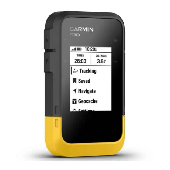
- Page 1 ETREX ® Owner’s Manual...
- Page 2 © 2023 Garmin Ltd. or its subsidiaries All rights reserved. Under the copyright laws, this manual may not be copied, in whole or in part, without the written consent of Garmin. Garmin reserves the right to change or improve its products and to make changes in the content of this manual without obligation to notify any person or organization of such changes or improvements. Go to www.garmin.com...
-
Page 3: Table Of Contents
Table of Contents Viewing Course Statistics....10 Deleting a Course......10 Activities..........10 Introduction........1 Viewing the Current Activity..... 10 Getting Started........1 Viewing Saved Activity Device Overview........1 Information........11 Installing AA Batteries......2 Collections..........12 Turning On the Device......3 Showing or Hiding Collections.. - Page 4 Device Information......19 Product Updates........19 Setting Up Garmin Express....19 Getting More Information..... 19 Viewing E-label Regulatory and Compliance Information....... 19 Device Care..........20 Cleaning the Device......20 Data Management........ 20 File Types........... 20 Connecting the Device to Your Computer...........
-
Page 5: Introduction
2 Turn on the device and select your language (Device Overview, page 1). 3 Pair your phone with the Garmin Explore (Pairing Your Phone, page 3). ™ The app allows you to receive notifications, view weather forecasts, search for live geocache data, and more. -
Page 6: Installing Aa Batteries
Hold to turn the device on. Hold to open the power menu. Press to turn the backlight on or off. Press to scroll through menus, options, and settings. Press to scroll through menus, options, and settings. Press to choose an option or open the menu for a page. Hold to save your current location as a waypoint. -
Page 7: Turning On The Device
Pairing Your Phone To use the connected features of your eTrex SE device, you should pair it with the Garmin Explore app. 1 Bring your compatible phone within 10 m (33 ft.) of your device. 2 From the main menu on your eTrex SE device, select Settings > Pair Phone. -
Page 8: Glances
Glances Your device comes preloaded with glances that provide quick information. Some glances require a Bluetooth connection to a compatible phone (Pairing Your Phone, page 3). Hold to view the glance loop. Compass: Displays an electronic compass. Sunrise/Sunset: Displays sunrise and sunset times, based on your GPS position. Weather: Displays the current temperature and weather forecast from your paired phone. -
Page 9: Changing The Map Orientation
Changing the Map Orientation 1 From the main menu, select Tracking, and press to scroll to the map page. 2 Press OK to open the options menu. 3 Select Map Settings > Orientation. 4 Select an option: • Select North Up to show north at the top of the page. •... -
Page 10: Setting The North Reference
Before you can calibrate the electronic compass, you must be outdoors, away from objects that influence magnetic fields, such as cars, buildings, or overhead power lines. The eTrex SE device has a 3-axis electronic compass. You should calibrate the compass after moving long distances, experiencing temperature changes, or changing the batteries. -
Page 11: Trip Computer Settings
Courses: A course is a sequence of waypoints or locations that leads you to your final destination. Activities: Your device records your path as an activity. Collections: You can use the Garmin Explore app to group related waypoints, courses, or activities into collections. You can show or hide the data in each collection on the device. -
Page 12: Viewing A Waypoint On The Map
Viewing a Waypoint on the Map 1 From the main menu, press to scroll through the apps on the navigator. 2 Select Saved > Waypoints. 3 Select a waypoint. 4 Press OK to open the options menu. 5 Select View on Map. Projecting a Waypoint You can create a new location by projecting the distance and bearing from a marked location to a new location. -
Page 13: Deleting A Waypoint
Deleting a Waypoint 1 From the main menu, press to scroll through the apps on the navigator. 2 Select Saved > Waypoints. 3 Select a waypoint. 4 Press OK to open the options menu. 5 Select Delete. Courses Creating a Course 1 From the main menu, press to scroll through the apps on the navigator. -
Page 14: Editing The Name Of A Course
Editing the Name of a Course You can customize the name of a course to make it distinct. 1 From the main menu, press to scroll through the apps on the navigator. 2 Select Saved > Courses. 3 Select a course. 4 Press OK to open the options menu. -
Page 15: Viewing Saved Activity Information
Stopping the Current Activity 1 From the main menu, press to scroll through the apps on the navigator. 2 Select Saved > Activities > Current Activity. 3 Select an option: • To pause recording, select Pause. • To save the activity, select Save > Done. TIP: You can edit the name or type before saving the activity. -
Page 16: Collections
Collections Showing or Hiding Collections You can create collections in the Garmin Explore app. To display data from your collections on your navigator, pair it with the app (Pairing Your Phone, page 3). 1 From the main menu, press to scroll through the apps on the navigator. -
Page 17: Navigating With Sight 'N Go
Navigating with Sight 'N Go You can point the device at an object in the distance, lock in the direction, and navigate to the object. 1 From the main menu, press to scroll through the apps on the navigator. 2 Select Navigate > Sight 'N Go. 3 Point the device at an object. -
Page 18: Calculating The Size Of An Area
You can register your device at www.geocaching.com to search for a list of nearby geocaches, or to search live information for millions of geocaches. 1 Connect to the Garmin Explore app (Pairing Your Phone, page 3). 2 From the main menu, press to scroll through the apps on the navigator. -
Page 19: Navigating To A Geocache
Navigating to a Geocache 1 From the main menu, press to scroll through the apps on the navigator. 2 Select Geocaching. 3 Select a geocache. 4 Press OK to open the options menu. 5 Select Go. Using Hints and Clues to find a Geocache You can use hints or clues, such as a description or coordinates, to help you find a geocache. -
Page 20: Customizing The Device
Customizing the Device Customizing the Main Menu You can move, add, and delete items in the main menu. 1 From the main menu, press to scroll through the apps on the navigator. 2 Select Edit. 3 Select an option: • Select a menu item, and press to change the placement of the item in the list. -
Page 21: Map Settings
Map Settings From the main menu, press to scroll through the apps on the navigator. Select Settings > Map. Orientation: Adjusts how the map is shown on the page. The North Up option shows north at the top of the page. -
Page 22: Time Settings
Course Trns. Dist.: Sets how far between course points when the navigator transitions to next point in the course, when Distance is selected for the Course Trans. settings. USB Mode: Sets the device to use MTP (media transfer protocol) or Garmin ®... -
Page 23: Resetting Data And Settings
• Go to support.garmin.com for additional manuals, articles, and software updates. • Go to buy.garmin.com, or contact your Garmin dealer for information about optional accessories and replacement parts. Viewing E-label Regulatory and Compliance Information The label for this device is provided electronically. The e-label may provide regulatory information, such as identification numbers provided by the FCC or regional compliance markings, as well as applicable product and licensing information. -
Page 24: Device Care
® ® ® File Types The handheld device supports these file types: • Files from Garmin Explore. • GPX route, track, and waypoint files. • GPX geocache files (Downloading Geocaches Using a Computer, page 14). • FIT courses, activities, and locations (waypoints). -
Page 25: Deleting Files
Operating temperature range From -20° to 60°C (from -4° to 140°F) Wireless frequency 2.4 GHz @ 6.16 dBm maximum The device withstands incidental exposure to water of up to 1 m for up to 30 min. For more information, go to www.garmin.com/waterrating. Device Information... -
Page 26: Appendix
Optional accessories, such as mounts, maps, fitness accessories, and replacement parts, are available at http:/ /buy.garmin.com or from your Garmin dealer. Attaching a Lanyard 1 Insert the loop of the lanyard through the slot in the device. 2 Thread the other end of the lanyard through the loop, and pull it tight. -
Page 27: Data Fields
Data Fields Some data fields require you to be navigating to display data. ACTIVITY DIST.: The distance traveled for the current track or activity. ALT LOCATION: The position of your alternate location. You must be navigating for this data to appear. AVERAGE LAP: The average lap time for the current activity. - Page 28 OVERALL AVG: The average speed while moving and stopped since the last reset. POINTER: An arrow points in the direction of the next waypoint or turn. You must be navigating for this data to appear. SPEED: The current rate of travel. STOPPED TIME: The total time stopped for the current activity.
- Page 30 March 2023 GUID-76DD39C5-047F-4599-892F-60C9207A6637 v1...
Need help?
Do you have a question about the ETREX SE and is the answer not in the manual?
Questions and answers