Table of Contents
Advertisement
Quick Links
Advertisement
Table of Contents

Subscribe to Our Youtube Channel
Related Manuals for GeoSIG GMS-GPS


Summary of Contents for GeoSIG GMS-GPS
- Page 1 GMS-GPS User Manual...
- Page 2 Copyright Notice No part of this document may be reproduced without the prior written consent of GeoSIG Ltd. Software described in this document is furnished under a license and may only be used or copied in accordance with the terms of such a license.
-
Page 3: Table Of Contents
GMS-GPS User Manual 02.09.2022 / V3 3 / 19 Table of Contents Warnings and Safety ......................4 Symbols and Abbreviations ....................4 1. Introduction ........................5 2. GPS Cable ........................5 2.1. GPS RS-232 cable ..........................5 2.2. GPS RS-485 cable ..........................5 3. -
Page 4: Warnings And Safety
The GPS system is operated by the government of the United States of America, which is solely responsible for its accuracy and maintenance. GPS provides only UTC time at 0° Greenwich meridian without daylight savings time adjustment. Symbols and Abbreviations Instrument GeoSIG Recorder, Digitiser or Data Acquisition system Global Positioning System Universal Time Clock... -
Page 5: Introduction
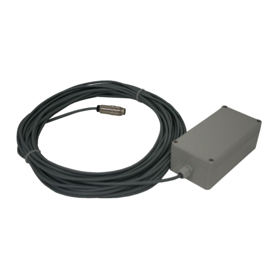
This document describes the principle of operation and installation instructions of the GPS. The GPS device is used with GeoSIG Instruments to provide the global coordinates of the GPS antenna and accurate date and time to the Instruments. It’s very useful for precise synchronisation of one or several interconnected Instruments. -
Page 6: Mounting The Gps Box
GMS-GPS User Manual 6 / 19 02.09.2022 / V3 3. Mounting the GPS Box It is recommended to perform a check of the GPS function before mounting the box to its final location, as described in section 5. The GPS device box can be fixed to various locations. The position of the box should be defined according to a position where GPS antenna can easily get the satellite signals. -
Page 7: Electrical Connection
GMS-GPS User Manual 02.09.2022 / V3 7 / 19 4. Electrical Connection 4.1. GPS Main Connector Pin Assignment 4.1.1. With RS-232 connection The GPS device is provided with an 8-pin main connector inside the box, supplied already connected. Table 1. Electrical connections of the RS-232 GPS device connector... -
Page 8: Mating Connector At The Instrument Side
GMS-GPS User Manual 8 / 19 02.09.2022 / V3 4.2. Mating Connector at the Instrument Side A mating connector must be used for connecting the GPS device to an Instrument. This connector is already assembled when the GPS is ordered together with the Instrument. -
Page 9: Gms Devices
GMS-GPS User Manual 02.09.2022 / V3 9 / 19 4.2.2. GMS Devices This includes the instruments GMS-XX and GMSplus. 4.2.2.1. Mating Connector at the Instrument Side for RS-232 connection Table 5. Electrical connections of an Instrument’s GPS device input connector... -
Page 10: Scai Or Nair Device
GMS-GPS User Manual 10 / 19 02.09.2022 / V3 4.2.3. SCAI or NAIR Device 4.2.3.1. Mating Connector at the Instrument Side for RS-232 connection Table 6. Electrical connections of an Instrument’s GPS device input connector Signal Standard Cable Colours Comment... -
Page 11: Device
GMS-GPS User Manual 02.09.2022 / V3 11 / 19 4.2.4. CR-5 Device 4.2.4.1. Mating Connector at the Instrument Side for RS-232 connection Table 8. Electrical connections of an Instrument’s GPS device input connector Signal Standard Cable Colours Comment GPS_1PPS+ Green... -
Page 12: Cr-6Plus Device
GMS-GPS User Manual 12 / 19 02.09.2022 / V3 4.2.5. CR-6 / CR-6plus Device 4.2.5.1. Mating Connector at the Instrument Side for RS-232 connection Table 9. Electrical connections of an Instrument’s GPS device input connector Signal Standard Cable Colours Comment... -
Page 13: Fora Device
GMS-GPS User Manual 02.09.2022 / V3 13 / 19 4.2.6. CR-7 / fora Device 4.2.6.1. Mating Connector at the Instrument Side for RS-232 connection Table 11. Electrical connections of an Instrument’s GPS device input connector Signal Standard Cable Colours Comment... -
Page 14: Configuration And Checking
5. Configuration and Checking 5.1. With a GXR-XX In order to synchronise a GeoSIG GSR-xx with the GPS, appropriate configuration should be made in the Instrument. Once power supply, computer and GPS are connected to the Instrument, such configuration and checks can be performed by logging into the Instrument using GeoDAS. -
Page 15: With A Gms-Xx Or A Gmsplus Or A Scai Or A Nair
5.2. With a GMS-XX or a GMSplus or a SCAI or a NAIR 5.2.1. Configuration of GPS In order to synchronise a GeoSIG GMS-xx or GMSplus with the GPS, appropriate configuration should be made in the Instrument. Once power supply, computer and GPS are connected to the Instrument, such configuration and checks can be performed by logging into the Instrument using GeoDAS. -
Page 16: Check Gps Data
02.09.2022 / V3 5.2.2. Check GPS data In order to verify the GPS in a GeoSIG GMS-xx or GMSplus, appropriate configuration should be made in the Instrument. Once power supply, computer and GPS are connected to the Instrument, such checks can be performed by logging into the Instrument using GeoDAS. -
Page 17: With A Cr-5P
17 / 19 5.3. With a CR-5P In order to synchronise a GeoSIG CR-5P with the GPS, appropriate configuration should be made in the Instrument. Once power supply, computer and GPS are connected to the Instrument, such configuration and checks can be performed by logging into the Instrument using GeoDAS. -
Page 18: With A Cr-6/Cr-6Plus Or A Cr-7 / Fora
5.4. With a CR-6/CR-6plus or a CR-7 / fora 5.4.1. Configuration of GPS In order to synchronise a GeoSIG GMS-xx or GMSplus with the GPS, appropriate configuration should be made in the Instrument. Once power supply, computer and GPS are connected to the Instrument, such configuration and checks can be performed by logging into the Instrument using GeoDAS. -
Page 19: Check Gps Data
19 / 19 5.4.2. Check GPS data In order to verify the GPS in a GeoSIG GMS-xx or GMSplus, appropriate configuration should be made in the Instrument. Once power supply, computer and GPS are connected to the Instrument, such checks can be performed by logging into the Instrument using GeoDAS.
Need help?
Do you have a question about the GMS-GPS and is the answer not in the manual?
Questions and answers