Advertisement
Advertisement
Table of Contents

Related Manuals for BW SENSING GI610 Series


Summary of Contents for BW SENSING GI610 Series
- Page 1 Serials GI610 High Precision FOG Integrated Navigation System Technical Manual...
- Page 2 GI610 High Precision FOG Integrated Navigation System Introduction BW-GI610 is a high-performance high-precision fiber micro-inertial navigation system developed by Bewis for aviation mapping, unmanned aerial vehicles, sea-based and roadbed fields. Built-in three-axis gyroscope (single-axis fiber, dual-axis MEMS) The three-axis accelerometer includes a BD/GPS/GLONAS three-mode receiver that measures the speed, position, and attitude of the carrier.
-
Page 3: Specifications
GI610 High Precision FOG Integrated Navigation System Specifications Performance Specifications (2m baseline) 0.1 deg 0.01deg /5min;0.06 deg /1h Satellite signal loss Attitude accuracy Rolling attitude accuracy ≤0.1 deg Pitch attitude accuracy ≤0.1 deg Speed accuracy 0.1m/s Combined external Single point positioning accuracy DGPS accuracy 0.5m /RTK accuracy 2cm Directional accuracy... -
Page 4: Product Size
GI610 High Precision FOG Integrated Navigation System Product Size Product Size:L153 ×W142 × H115(mm) Note: Unfilled dimensional tolerances are performed in accordance with GB/T1804-2000 Class C. BEWIS SENSING TECHNOLOGY LLC www.bwsensing.com Tel: +86 510 8573 7158... -
Page 5: Product Installation
GI610 High Precision FOG Integrated Navigation System Product installation The correct installation method can avoid measurement error. The inertial measurement unit produces an absolutely smooth surface by grinding on the underside and measuring surface for installation .The following points should be made when installing the sensor: First of all, to ensure that the sensor mounting surface and the measured surface completely close, the measured surface should be as horizontal as possible, so that we can reduce installation error. -
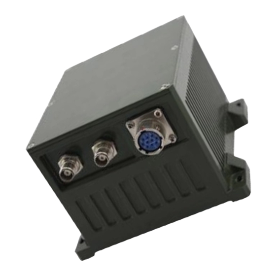
Page 6: Electrical Connections
GI610 High Precision FOG Integrated Navigation System Electrical connections Data cable RS422 interface definition, DB9 female: Interface definition DB9 connector pin Remarks Receive + Receive - Transmit + Transmit - Debugging software Software usage steps: Ensure that the inertial navigation is absolutely static,correctly connect the serial port hardware of ①... - Page 7 GI610 High Precision FOG Integrated Navigation System Protocol After the system is powered on, the normal operating time is 20Hz frequency, RS422 communication 115200bps, n, 8, 1 broadcast broadcast navigation data, 48 bytes per frame data as shown in the following table: Naviga on data Byte number Content...
- Page 8 GI610 High Precision FOG Integrated Navigation System Executive standard Enterprise Quality System Standard: ISO9001:2008 Standard(Certificate No.:10114Q16846ROS) ● CE certification (certificate number: 3854210814) ● ROHS (certificate number: SO81426003) ● GJB 2426A-2004 Fiber Optic Gyro Test Method ● GBT 18459-2001 sensor main static performance index calculation method ●...
- Page 9 GI610 High Precision FOG Integrated Navigation System Wuxi Bewis Sensing Technology LLC Address: Building 30, No. 58 Xiuxi Road, Binhu District, Wuxi City Hotline: 400-618-0510 Tel: +86 510 85737178-801 Email: sales@bwsensing.com Website: www.bwsensing.com...
Need help?
Do you have a question about the GI610 Series and is the answer not in the manual?
Questions and answers