Table of Contents
Advertisement
Quick Links
Advertisement
Table of Contents

Related Manuals for Leica DSX


Summary of Contents for Leica DSX
- Page 1 Leica DSX User Manual Version 1.0 English...
- Page 2 Leica USB stick • https://myworld.leica-geosystems.com • Leica Geosystems On the last page of this manual, you can find the address of Leica Geosystems address book headquarters. For a list of regional contacts, please visit http://leica-geosystems.com/contact-us/sales_support. myWorld@Leica Geosystems (https://myworld.leica-geosystems.com) offers a wide range of services, information and training material.
- Page 3 Description myProducts Add all products that you and your company own and explore your world of Leica Geosystems: View detailed information on your products and update your products with the latest software and keep up- to-date with the latest documentation.
-
Page 4: Table Of Contents
System Components Delivery Contents DSX Components Accessories General Battery Handling Requirements for Using a GNSS Antenna with the DSX Setup Unfolding and Adjusting the Handle Attaching and Connecting the Laptop or Tablet Inserting the Battery Mounting the Pole Support (Surveyor Kit Only) -
Page 5: Safety Directions
Safety Directions General Description The following directions enable the person responsible for the product, and the person who actually uses the equipment, to anticipate and avoid opera- tional hazards. The person responsible for the product must ensure that all users understand these directions and adhere to them. -
Page 6: Definition Of Use
Suitable for use in dry environments only and not under adverse conditions. Responsibilities Manufacturer of the Leica Geosystems AG, CH-9435 Heerbrugg, hereinafter referred to as Leica product Geosystems, is responsible for supplying the product, including the User Man- ual and original accessories, in a safe condition. -
Page 7: Hazards Of Use
To be familiar with local regulations relating to safety and accident pre- • vention. To inform Leica Geosystems immediately if the product and the applica- • tion becomes unsafe. To ensure that the national laws, regulations and conditions for the oper- •... - Page 8 DANGER Risk of electrocution Because of the risk of electrocution, it is dangerous to use poles, levelling staffs and extensions in the vicinity of electrical installations such as power cables or electrical railways. Precautions: ▶ Keep at a safe distance from electrical installations. If it is essential to work in this environment, first contact the safety authorities responsible for the electrical installations and follow their instructions.
- Page 9 Precautions: ▶ Do not open the product! ▶ Only Leica Geosystems authorised service centres are entitled to repair these products. For the AC/DC power supply and the battery charger: WARNING Electric shock due to use under wet and severe conditions If unit becomes wet it may cause you to receive an electric shock.
- Page 10 • Precautions: ▶ Do not open the product! ▶ Only Leica Geosystems authorised service centres are entitled to repair these products. WARNING Inappropriate mechanical influences to batteries During the transport, shipping or disposal of batteries it is possible for inap- propriate mechanical influences to constitute a fire hazard.
- Page 11 Risk of injuries to users and equipment destruction due to lack of repair knowledge. Precautions: ▶ Only authorised Leica Geosystems Service Centres are entitled to repair these products. CAUTION Before any cleaning procedure, ensure that the instrument is switched off and the battery has been removed.
-
Page 12: Electromagnetic Compatibility (Emc)
Although the product meets the strict regulations and standards which are in force in this respect, Leica Geosystems cannot completely exclude the possi- bility that function of the product may be disturbed in such an electromag- netic environment. -
Page 13: Fcc Statement, Applicable In U
Precautions: ▶ Although the product meets the strict regulations and standards which are in force in this respect, Leica Geosystems cannot completely exclude the possibility that other equipment can be disturbed or that humans or animals can be affected. ▶... - Page 14 CFR47 Section 2.405(a)-(e), is followed by the UWB equipment user. CAUTION Changes or modifications not expressly approved by Leica Geosystems for compliance could void the user's authority to operate the equipment. Safety Directions...
-
Page 15: Requirements Of Rss-220 For Ground Antennas (En/Fr), Applicable In Canada
CANADIAN REPRESENTATIVE Company Name : Leica Geosystems Ltd CN Number : 3177B Contact Name : Sudha Sachdeva City : SCARBOROUGH, Ontario M1W3S2 Telephone No : +1 416 497 2463 Email : sudha.sachdeva@leicaus.com... -
Page 16: Description Of The System
Description of the System General Area of application The DSX system is designed to detect and locate both metallic and non-metal- lic underground utilities. It provides georeferenced utility maps in survey-grade accuracy when a supported positioning system is used. System Components... -
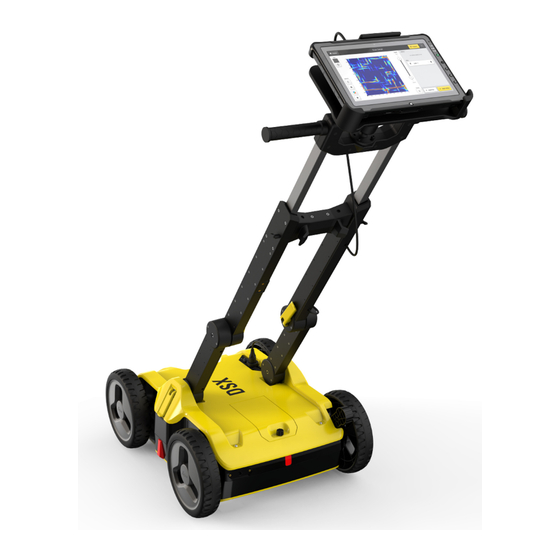
Page 17: Dsx Components
Handle The handle of the DSX can be adjusted both in height and inclination. For easy transport of the DSX, the handle can be folded up. The LAN cable for connecting to the tablet is by the... -
Page 18: Accessories
The DSX battery is removable from the battery compartment and is ☞ chargeable. You cannot turn on the DSX while the battery compartment is empty. ☞ Place the battery in the charger and use the appropriate plug head before charging. -
Page 19: Requirements For Using A Gnss Antenna With The Dsx
Requirements for Using a GNSS Antenna with the DSX Requirements The DSX can be used with a GNSS antenna to position the radar-scanning data in an absolute coordinates system and to receive real-time positional correc- tions while the DSX cart is moving and collecting data. -
Page 20: Setup
Setup Procedure for setting The setup procedure of the DSX consists of the following steps: up the DSX Unfolding and adjusting the handle (refer to "3.1 Unfolding and Adjusting • the Handle") Inserting the battery (refer to "3.3 Inserting the Battery") •... -
Page 21: Inserting The Battery
• Use the double socket arm to hold the two RAM balls: Adjust the tablet cradle until optimal inclination and then tighten the screw on the double socket arm. Plug in the DSX LAN cable to the tablet. 0019637_001 xxxxxx_001... -
Page 22: Mounting The Pole Support (Surveyor Kit Only)
Place the lower clamp in the housing bracket, and then fit the upper clamp in the handle bracket. Tighten the screw of the handle bracket. Switching the DSX ON/OFF Switch the DSX device ON/OFF 0019637_001 xxxxxx_001 xxxxxx_001 Press the ON/OFF key on the DSX. Setup... -
Page 23: Calibrating The Encoders
Ensure that the tablet is connected to the control unit. ☞ Turn on the control unit of the DSX. Turn on the tablet and start the DXplore software. Start the calibration procedure with the DXplore software. (Refer to (→... -
Page 24: Software
Software Software Installation Requirements for When purchasing a DSX package that includes a tablet, the DXplore software installing the DXplore is already installed on the tablet. software However, you can also operate the DSX with any laptop/tablet. When installing the DXplore software on another laptop/tablet, respect the following require- ments. -
Page 25: Planning A Survey
Planning a Survey Jobsite Investigation To carry out a survey with the DSX in the most efficient way, gather all availa- ble information: Make yourself familiar with the jobsite features. • Obtain technical maps about existing utilities on the jobsite. -
Page 26: Procedures For Working With The Dsx
Before departing to the jobsite, ensure that the laptop/tablet and ☞ the DSX battery are fully charged. At the jobsite, set up the DSX and mount the accessories, if availa- ble. Refer to "3 Setup". Depending on the purpose of the survey and the available accesso-... -
Page 27: Mapping Utilities Without Using Gps
Position the DSX at the starting point of the next line to be scanned. Repeat the steps 6 to 10 until the jobsite is covered. Mapping Utilities without Using GPS Procedure for map- If a GPS antenna is not available, follow these steps to map the detected util- ping utilities without ities based on a measurement grid. -
Page 28: Mapping Utilities Using Gps
If available, mount the spray support. ☞ Mount the GPS support on the DSX and attach the pole with the GPS antenna. Ensure that the laptop/tablet is connected to the control unit and to the antenna. - Page 29 Position the DSX at the starting point of the next line to be scanned. Repeat the steps 8 to 12 until the jobsite is covered. Before returning to the main menu, save a report of the survey with the Survey Report dialogue. (Refer to (→...
-
Page 30: Care And Transport
Transport Shipping When transporting the product by rail, air or sea, always use the complete original Leica Geosystems packaging, container and cardboard box, or its equivalent, to protect against shock and vibration. Shipping, transport of When transporting or shipping batteries, the person responsible for the prod-... - Page 31 Connectors with dust Wet connectors must be dry before attaching the dust cap. caps Care and Transport...
-
Page 32: Technical Data
Number of Hardware Channels Antenna Central Fre- 600 MHz quencies Antenna Orientation Broadside antenna array in the direction which is perpendicular to the DSX moving direction Sampling Frequency 400 kHz Battery for DSX Type Li-Ion Voltage 14.8 V Capacity GEB242 5.8 Ah... -
Page 33: Conformity To European Regulations
Scan Rate per Channel 381 scans per second – for 512 Samples per Scan Scan Interval 42 scans per metre Positioning Two integrated encoders on the rear wheels • GNSS antenna or Total Positioning System • (TPS – surveyor kit only) Environmental speci- Temperature fications... -
Page 34: Software Licence Agreement
Rights, Limitation of Liability, Exclusion of other Assurances, Governing Law and Place of Jurisdiction. Please make sure, that at any time you fully comply with the terms and conditions of the Leica Geosystems Software Licence Agreement. Such agreement is provided together with all products and can also be refer- red to and downloaded at the Leica Geosystems home page at http://leica-geosystems.com/about-us/compliance-standards/legal-documents... - Page 36 900644-1.0.0en Original text (900644en-1.0.0) Published in Switzerland © 2019 Leica Geosystems AG, Heerbrugg, Switzerland Leica Geosystems AG Heinrich-Wild-Strasse CH-9435 Heerbrugg Switzerland Phone +41 71 727 31 31 www.leica-geosystems.com...
Need help?
Do you have a question about the DSX and is the answer not in the manual?
Questions and answers