
Related Manuals for Brunton ECLIPSE 8096


Summary of Contents for Brunton ECLIPSE 8096
- Page 1 Copyright 2000, The Brunton Company A subsidiary of Silva Production, AB Printed in U.S.A. form 62-8096 rev 0005...
-
Page 2: Table Of Contents
1 -- Orientation: Eclipse 8096 GPS Compass ... 1 2 -- Magnetic Declination ... 2 3 -- Field Bearing ... 3 4 -- Direction Of Travel ... 4 5 -- Back Bearing ... 5 6 -- Topographic Map ... 5 7 -- Map Bearing ... -
Page 3: Orientation: Eclipse 8096 Gps Compass
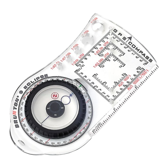
1 -- Orientation: Eclipse 8096 GPS Compass The Eclipse 8096 GPS Compass compliments any GPS receiver, by combining the features of a compass and positioning for GPS receiver use. The Orientation section provides a description of important Eclipse 8096 parts. Detailed description of Eclipse 8096 operation is provided throughout the instruction manual. -
Page 4: Magnetic Declination
1.10 Reversible Ruler System (Fig 2) The Eclipse 8096 provides a reversible ruler for measurements in inches or centimeters. 2 -- Magnetic Declination Magnetic declination is the difference between true geographic north (north pole) and magnetic north (in northern Canada), with respect to your position. -
Page 5: Field Bearing
2.1 Magnetic Declination Adjustment 1. Determine magnetic declination at your position. 2. Locate magnetic declination scale on the back side of azimuth ring. (Fig 5, p 4) 3. Grasp azimuth ring in one hand and the vial in the other. (Fig 5, p 4) 4. -
Page 6: Direction Of Travel
Figure 5 Figure 6 Figure 7 4. Read bearing -- 170 . (Fig 7) 4 -- Direction Of Travel When field bearing to destination is already known, adjust compass to known field bearing, sight a bearing to an object and travel to object. The bearing you travel is known as the direction of travel. Figure 8 1. -
Page 7: Back Bearing
7 -- Map Bearing Some GPS receivers calculate a waypoint by entering a bearing and distance from a known position. The Eclipse 8096 allows for both bearing and distance determination. First, find the bearing. 7.1 Map Alignment Align a topo-map to true north, then find a map bearing. It is possible to compare the actual terrain to the map, using this method. -
Page 8: Distance Measurement
Now that you have established a bearing, find distance using the ruler. If needed, slide the ruler completely off the Eclipse 8096, flip over, and slide ruler back on the compass. (Fig 17) 6 Inches 1. Measure distance from the “point” to the “X” on the map - 6 inches. -
Page 9: Positioning
Actual distance is: 12,000 feet or approximately 2.25 miles. 9 -- Positioning GPS receivers require an understanding of coordinate positioning in order to use waypoints. This section explains Universal Transverse Mercator (UTM) grid, latitude-longitude and triangulation to find a position. Use the method best suited for your application. 9.1 UTM Coordinate System Universal Transverse Mercator (UTM) is a square grid coordinate system measured in meters from the Equator (0... - Page 10 5. Place the small hole of the UTM roamer scale over the “X”. (Fig 22) - Make sure the scale is parallel to the drawn easting and northing grid lines. 6. Count from the “X” to the nearest left easting line - 100, 200, ... 500 & 600 m. 7.
- Page 11 3. Place UTM roamer scale 4. Mark the GPS position Figure 24 Since the Department of Defence intentionally degrades the accuracy of most GPS receivers, you have plotted an approximate position. Accuracy of a civilian GPS position randomly varies between 15 and 100 meters (49.2 and 328 feet), 95% of the time.
- Page 12 3. Place scale vertically, until bound by both latitude lines, and next to the “X”. (Fig 30) Figure 29 - Add values similar to time on a clock. 02’ 30” 00’ 50” 02’ 80” = 43 03’ 20” N. Latitude 5.
-
Page 13: Additional Information
add to reach the GPS position (43 - Add: 2’ 2. Position the 1:24k latitude-longitude scale, on the template, until bound by both latitude lines. - Place scale anywhere within the rectangle, as long as it is bound by the latitude lines. (Fig 32) 3. -
Page 14: Gps Compass & Template Specifications
Before heading into the field, practice using the Eclipse 8096 GPS Compass with a GPS receiver and a map in a familiar area. Become expert with a map, compass and GPS receiver, and educate yourself on survival techniques. 11 -- GPS Compass & Template Specifications... -
Page 15: Eclipse 8096 Eclipse 8096 Eclipse 8096 Eclipse 8096 Eclipse
8 — Mesurer la distance ... 17 9 — Positionnement ... 18 10 — Information supplémentaires ... 22 11 — Spécifications de la boussole GPS et du pochoir ... 22 ECLIPSE 8096 ECLIPSE 8096 ECLIPSE 8096 ECLIPSE 8096 ECLIPSE 8096... -
Page 16: Orientation: La Boussole Gps
1 — Orientation: la boussole GPS La boussole GPS Eclipse 8096 complète tout récepteur GPS, car elle peut être utilisée comme boussole et pour la mise en position du récepteur GPS. La section Orientation contient la description des pièces importantes de Eclipse 8096. Le manuel d’instructions donne la description détaillée du fonctionnement de Eclipse 8096. -
Page 17: Déclinaison Magnétique
1.10 Système à règle réversible (Fig. 2) La boussole Eclipse 8096 a une règle réversible pour les mesures en pouces ou en centimètres. 2 — Déclinaison magnétique La déclinaison magnétique est la différence entre le nord géographique (le Pôle Nord) et le nord magnétique (au nord du Canada) par rapport à... -
Page 18: Relèvement
7 — Relèvement sur carte Certains récepteurs GPS calculent un point de cheminement en entrant un relèvement et la distance jusqu’à une position connue. La boussole 8096 permet la détermination du relèvement ainsi que de la distance. Tout d’abord, trouvez le relèvement. -
Page 19: Mesurer La Distance
3. Marquez la position de départ avec un «point», la destination avec un «X», et tirez une ligne entre les deux. 4. Posez la boussole 8096 près de la ligne de relèvement, tel qu’indiqué dans la Figure 16. 5. Faites tourner le cadran azimutal jusqu’à ce que le cercle d’orientation bleu indique une direction vers le nord, et les lignes rouges sur le cercle gradué... -
Page 20: Positionnement
2. Trouvez la distance réelle, en comparant la distance mesurée à l’échelle de la carte. (Fig. 19) La distance réelle est: 12 000 pieds ou environ 2,25 milles. Figure 19 - p. 7 9 — Positionnement Les utilisateurs de récepteurs GPS doivent connaître le positionnement par coordonnées pour pouvoir utiliser les points de cheminement. - Page 21 6. Comptez à partir du «X» jusqu’à l’abscisse gauche la plus proche - 100, 200, ... 500 et 600 m. 7. Ajoutez 600 m. à l’abscisse gauche la plus proche. - 600 m E + 599000 m E = 599600 m E 8.
- Page 22 2. Tracez 3/4 de cercle. (Fig. 26) 3. Terminez le cercle soit à main levée, soit en faisant d’abord tourner le cercle de certitude autour de la position. Figure 26 - p. 9 Maintenant, vous êtes certain à 95 % que votre position réelle est à l’intérieur du cercle de 100 mètres.
- Page 23 5. Maintenant, incliner l’échelle jusqu’à ce qu’elle soit à côté du «X», délimitée par les deux lignes de longitude. (Fig. 31) Figure 31 - p. 10 Lignes de longitude 6. Au point «X», ajoutez la valeur de l’échelle (1’15") à la valeur de longitude la plus basse (108 22' 30") 23' 45"...
-
Page 24: Information Supplémentaires
GPS arrête de fonctionner. Avant de partir en randonnée, exercez-vous à l’emploi de la Boussole Eclipse 8096 GPS avec un récepteur GPS et une carte dans une région connue. Spécialisez-vous dans la lecture de cartes, et dans l’utilisation d’une boussole et d’un récepteur GPS et apprenez les techniques de survie. -
Page 25: Optional Information
PRICE PAID $___________________ OPTIONAL INFORMATION TYPE OF STORE PURCHASED FROM: A. CATALOG D. SPORTING GOODS OTHER____________________________________________________ DO YOU OWN OTHER BRUNTON PRODUCTS? I DECIDED TO BUY THIS COMPASS BECAUSE OF... A. RECOMMENDATION D. SALESPERSON OTHER____________________________________________________ THIS COMPASS WILL BE USED PRIMARILY FOR...
Need help?
Do you have a question about the ECLIPSE 8096 and is the answer not in the manual?
Questions and answers